Bere Wood
Wood, Forest in Kent Dover
England
Bere Wood
Bere Wood is a picturesque woodland located in the county of Kent, England. Covering an area of approximately 80 hectares, the wood is situated near the village of Selling, just a few miles south of Faversham. This ancient woodland is a treasured natural gem within the region.
Bere Wood is predominantly composed of mixed broadleaf trees, including oak, ash, beech, and chestnut, creating a diverse and vibrant ecosystem. The wood is characterized by its dense canopy, which provides a cool and shaded environment during the summer months. In spring, the forest floor comes alive with a carpet of bluebells, adding a touch of color and beauty to the surroundings.
The wood is crisscrossed by several well-maintained footpaths, allowing visitors to explore its natural wonders. These paths offer stunning views of the woodland, meandering through the trees and providing glimpses of the local wildlife. The area is home to a variety of bird species, such as woodpeckers and nightingales, making it a popular spot for birdwatchers.
Bere Wood is also rich in historical and archaeological significance. The remains of an Iron Age settlement have been discovered within its boundaries, offering insights into the ancient past of the area. Additionally, the wood has a long history of traditional woodland management, with evidence of coppicing and charcoal production dating back centuries.
Overall, Bere Wood provides a tranquil and enchanting escape from the hustle and bustle of modern life. Its natural beauty, diverse flora and fauna, and rich history make it a cherished destination for nature enthusiasts and those seeking a peaceful retreat in the heart of Kent.
If you have any feedback on the listing, please let us know in the comments section below.
Bere Wood Images
Images are sourced within 2km of 51.146385/1.3461714 or Grid Reference TR3443. Thanks to Geograph Open Source API. All images are credited.


![St Margaret's at Cliffe buildings [1] Cliffe House, High Street, was built circa 1830. Constructed of painted brick with rendered quoins and a hipped slate roof. Now flats. Listed, grade II, with details at: <span class="nowrap"><a title="https://historicengland.org.uk/listing/the-list/list-entry/1101769" rel="nofollow ugc noopener" href="https://historicengland.org.uk/listing/the-list/list-entry/1101769">Link</a><img style="margin-left:2px;" alt="External link" title="External link - shift click to open in new window" src="https://s1.geograph.org.uk/img/external.png" width="10" height="10"/></span>
St Margaret’s at Cliffe is a coastal village some 3 miles northeast of Dover. The village is the place in Britain that is nearest to the coast of France, 18 miles distant. The area has been settled since Anglo-Saxon times, and the village became a high class resort in the nineteenth century. The area has always been at the front line of cross Channel conflicts.](https://s3.geograph.org.uk/geophotos/07/08/68/7086863_1b38ce43.jpg)
![St Margaret's at Cliffe buildings [2] This large building was originally a series of outbuildings to Cliffe House <a href="https://www.geograph.org.uk/photo/7086863">TR3544 : St Margaret's at Cliffe buildings [1]</a>. Constructed at various dates from the 18th century to the end of the 19th century. Constructed of brick, partly weatherboarded, partly rendered, partly painted, under a mix of slate and tile roofs. Until recently, a hotel, now holiday accommodation. Listed, for group value, grade II, with details at: <span class="nowrap"><a title="https://historicengland.org.uk/listing/the-list/list-entry/1363365" rel="nofollow ugc noopener" href="https://historicengland.org.uk/listing/the-list/list-entry/1363365">Link</a><img style="margin-left:2px;" alt="External link" title="External link - shift click to open in new window" src="https://s1.geograph.org.uk/img/external.png" width="10" height="10"/></span>
St Margaret’s at Cliffe is a coastal village some 3 miles northeast of Dover. The village is the place in Britain that is nearest to the coast of France, 18 miles distant. The area has been settled since Anglo-Saxon times, and the village became a high class resort in the nineteenth century. The area has always been at the front line of cross Channel conflicts.](https://s2.geograph.org.uk/geophotos/07/08/68/7086866_997eeb12.jpg)
![Parish church [1] The Anglican parish church of St Margaret was built circa 1150, replacing an earlier church of which a few fragments remain in the chancel. The tower was added in the late 12th century, and partly rebuilt in 1713. The church was restored in 1864. Constructed of flint and rubble stone under slate roofs, with a tile roof to the south aisle. Listed, grade I, with details at: <span class="nowrap"><a title="https://historicengland.org.uk/listing/the-list/list-entry/1101743" rel="nofollow ugc noopener" href="https://historicengland.org.uk/listing/the-list/list-entry/1101743">Link</a><img style="margin-left:2px;" alt="External link" title="External link - shift click to open in new window" src="https://s1.geograph.org.uk/img/external.png" width="10" height="10"/></span>
St Margaret’s at Cliffe is a coastal village some 3 miles northeast of Dover. The village is the place in Britain that is nearest to the coast of France, 18 miles distant. The area has been settled since Anglo-Saxon times, and the village became a high class resort in the nineteenth century. The area has always been at the front line of cross Channel conflicts.](https://s3.geograph.org.uk/geophotos/07/08/68/7086867_84ca5e88.jpg)
![Parish church [2] The west doorway.
The Anglican parish church of St Margaret was built circa 1150, replacing an earlier church of which a few fragments remain in the chancel. The tower was added in the late 12th century, and partly rebuilt in 1713. The church was restored in 1864. Constructed of flint and rubble stone under slate roofs, with a tile roof to the south aisle. Listed, grade I, with details at: <span class="nowrap"><a title="https://historicengland.org.uk/listing/the-list/list-entry/1101743" rel="nofollow ugc noopener" href="https://historicengland.org.uk/listing/the-list/list-entry/1101743">Link</a><img style="margin-left:2px;" alt="External link" title="External link - shift click to open in new window" src="https://s1.geograph.org.uk/img/external.png" width="10" height="10"/></span>
St Margaret’s at Cliffe is a coastal village some 3 miles northeast of Dover. The village is the place in Britain that is nearest to the coast of France, 18 miles distant. The area has been settled since Anglo-Saxon times, and the village became a high class resort in the nineteenth century. The area has always been at the front line of cross Channel conflicts.](https://s1.geograph.org.uk/geophotos/07/08/68/7086869_d03eaa7e.jpg)
![Parish church [3] A closer look at the west doorway.
The Anglican parish church of St Margaret was built circa 1150, replacing an earlier church of which a few fragments remain in the chancel. The tower was added in the late 12th century, and partly rebuilt in 1713. The church was restored in 1864. Constructed of flint and rubble stone under slate roofs, with a tile roof to the south aisle. Listed, grade I, with details at: <span class="nowrap"><a title="https://historicengland.org.uk/listing/the-list/list-entry/1101743" rel="nofollow ugc noopener" href="https://historicengland.org.uk/listing/the-list/list-entry/1101743">Link</a><img style="margin-left:2px;" alt="External link" title="External link - shift click to open in new window" src="https://s1.geograph.org.uk/img/external.png" width="10" height="10"/></span>
St Margaret’s at Cliffe is a coastal village some 3 miles northeast of Dover. The village is the place in Britain that is nearest to the coast of France, 18 miles distant. The area has been settled since Anglo-Saxon times, and the village became a high class resort in the nineteenth century. The area has always been at the front line of cross Channel conflicts.](https://s0.geograph.org.uk/geophotos/07/08/68/7086872_74a2f93b.jpg)
![Parish church [4] Part of the churchyard.
The Anglican parish church of St Margaret was built circa 1150, replacing an earlier church of which a few fragments remain in the chancel. The tower was added in the late 12th century, and partly rebuilt in 1713. The church was restored in 1864. Constructed of flint and rubble stone under slate roofs, with a tile roof to the south aisle. Listed, grade I, with details at: <span class="nowrap"><a title="https://historicengland.org.uk/listing/the-list/list-entry/1101743" rel="nofollow ugc noopener" href="https://historicengland.org.uk/listing/the-list/list-entry/1101743">Link</a><img style="margin-left:2px;" alt="External link" title="External link - shift click to open in new window" src="https://s1.geograph.org.uk/img/external.png" width="10" height="10"/></span>
St Margaret’s at Cliffe is a coastal village some 3 miles northeast of Dover. The village is the place in Britain that is nearest to the coast of France, 18 miles distant. The area has been settled since Anglo-Saxon times, and the village became a high class resort in the nineteenth century. The area has always been at the front line of cross Channel conflicts.](https://s2.geograph.org.uk/geophotos/07/08/68/7086874_37b12fbe.jpg)
![Parish church [5] Some elaborate tombs in the churchyard.
The Anglican parish church of St Margaret was built circa 1150, replacing an earlier church of which a few fragments remain in the chancel. The tower was added in the late 12th century, and partly rebuilt in 1713. The church was restored in 1864. Constructed of flint and rubble stone under slate roofs, with a tile roof to the south aisle. Listed, grade I, with details at: <span class="nowrap"><a title="https://historicengland.org.uk/listing/the-list/list-entry/1101743" rel="nofollow ugc noopener" href="https://historicengland.org.uk/listing/the-list/list-entry/1101743">Link</a><img style="margin-left:2px;" alt="External link" title="External link - shift click to open in new window" src="https://s1.geograph.org.uk/img/external.png" width="10" height="10"/></span>
St Margaret’s at Cliffe is a coastal village some 3 miles northeast of Dover. The village is the place in Britain that is nearest to the coast of France, 18 miles distant. The area has been settled since Anglo-Saxon times, and the village became a high class resort in the nineteenth century. The area has always been at the front line of cross Channel conflicts.](https://s0.geograph.org.uk/geophotos/07/08/68/7086876_c39546be.jpg)
![St Margaret's at Cliffe features [1] An information board about the village.
St Margaret’s at Cliffe is a coastal village some 3 miles northeast of Dover. The village is the place in Britain that is nearest to the coast of France, 18 miles distant. The area has been settled since Anglo-Saxon times, and the village became a high class resort in the nineteenth century. The area has always been at the front line of cross Channel conflicts.](https://s2.geograph.org.uk/geophotos/07/08/68/7086878_2a01f517.jpg)
![St Margaret's at Cliffe buildings [3] The former Red Lion public house which closed circa 2015. Constructed circa 1825 replacing an earlier building. Built of flint with red brick dressings and tile hung with a tile roof, extended with white brick under a slate roof. Listed, grade II, with details at: <span class="nowrap"><a title="https://historicengland.org.uk/listing/the-list/list-entry/1070068" rel="nofollow ugc noopener" href="https://historicengland.org.uk/listing/the-list/list-entry/1070068">Link</a><img style="margin-left:2px;" alt="External link" title="External link - shift click to open in new window" src="https://s1.geograph.org.uk/img/external.png" width="10" height="10"/></span>
St Margaret’s at Cliffe is a coastal village some 3 miles northeast of Dover. The village is the place in Britain that is nearest to the coast of France, 18 miles distant. The area has been settled since Anglo-Saxon times, and the village became a high class resort in the nineteenth century. The area has always been at the front line of cross Channel conflicts.](https://s3.geograph.org.uk/geophotos/07/08/68/7086879_837cf970.jpg)
![St Margaret's at Cliffe buildings [11] This former chapel is in Sea Street.
St Margaret’s at Cliffe is a coastal village some 3 miles northeast of Dover. The village is the place in Britain that is nearest to the coast of France, 18 miles distant. The area has been settled since Anglo-Saxon times, and the village became a high class resort in the nineteenth century. The area has always been at the front line of cross Channel conflicts.](https://s0.geograph.org.uk/geophotos/07/08/77/7087756_2dd803e4.jpg)
![Dover Castle [6] The view from the roof of the keep, looking northeast towards the transmission towers on Fox Hill Down.
With its strategically important position overlooking the Straits of Dover, Dover Castle is often described as the ‘key to England’. The site was fortified by earthworks in the Iron Age and holds a Roman lighthouse, claimed to be the oldest standing building in England. The lighthouse was adapted as a belfry for the adjacent Saxon church built circa 1000. A castle was founded in 1066 and added to later, but the recognizable castle dates from the 1180s. There were various additions and repairs but the castle played no part in the English Civil War. There was much new building in the 1750s when at war with France, and the castle was much modified in the 1790s. The castle played its part in both world wars and in the Cold War, and an army presence remained until 2015. The castle is listed, grade I, with details at: <span class="nowrap"><a title="https://historicengland.org.uk/listing/the-list/list-entry/1070326" rel="nofollow ugc noopener" href="https://historicengland.org.uk/listing/the-list/list-entry/1070326">Link</a><img style="margin-left:2px;" alt="External link" title="External link - shift click to open in new window" src="https://s1.geograph.org.uk/img/external.png" width="10" height="10"/></span> There are a number of other listed building within the castle site which is a Scheduled Ancient Monument and there is much detail at: <span class="nowrap"><a title="https://historicengland.org.uk/listing/the-list/list-entry/1019075" rel="nofollow ugc noopener" href="https://historicengland.org.uk/listing/the-list/list-entry/1019075">Link</a><img style="margin-left:2px;" alt="External link" title="External link - shift click to open in new window" src="https://s1.geograph.org.uk/img/external.png" width="10" height="10"/></span>](https://s0.geograph.org.uk/geophotos/07/09/82/7098212_5150218f.jpg)
![Dover Castle [46] The view looking east northeast from the roof of the Fire Command Post and Port War Signal Station.
With its strategically important position overlooking the Straits of Dover, Dover Castle is often described as the ‘key to England’. The site was fortified by earthworks in the Iron Age and holds a Roman lighthouse, claimed to be the oldest standing building in England. The lighthouse was adapted as a belfry for the adjacent Saxon church built circa 1000. A castle was founded in 1066 and added to later, but the recognizable castle dates from the 1180s. There were various additions and repairs but the castle played no part in the English Civil War. There was much new building in the 1750s when at war with France, and the castle was much modified in the 1790s. The castle played its part in both world wars and in the Cold War, and an army presence remained until 2015. The castle is listed, grade I, with details at: <span class="nowrap"><a title="https://historicengland.org.uk/listing/the-list/list-entry/1070326" rel="nofollow ugc noopener" href="https://historicengland.org.uk/listing/the-list/list-entry/1070326">Link</a><img style="margin-left:2px;" alt="External link" title="External link - shift click to open in new window" src="https://s1.geograph.org.uk/img/external.png" width="10" height="10"/></span> There are a number of other listed building within the castle site which is a Scheduled Ancient Monument and there is much detail at: <span class="nowrap"><a title="https://historicengland.org.uk/listing/the-list/list-entry/1019075" rel="nofollow ugc noopener" href="https://historicengland.org.uk/listing/the-list/list-entry/1019075">Link</a><img style="margin-left:2px;" alt="External link" title="External link - shift click to open in new window" src="https://s1.geograph.org.uk/img/external.png" width="10" height="10"/></span>](https://s2.geograph.org.uk/geophotos/07/09/88/7098882_e25e97be.jpg)
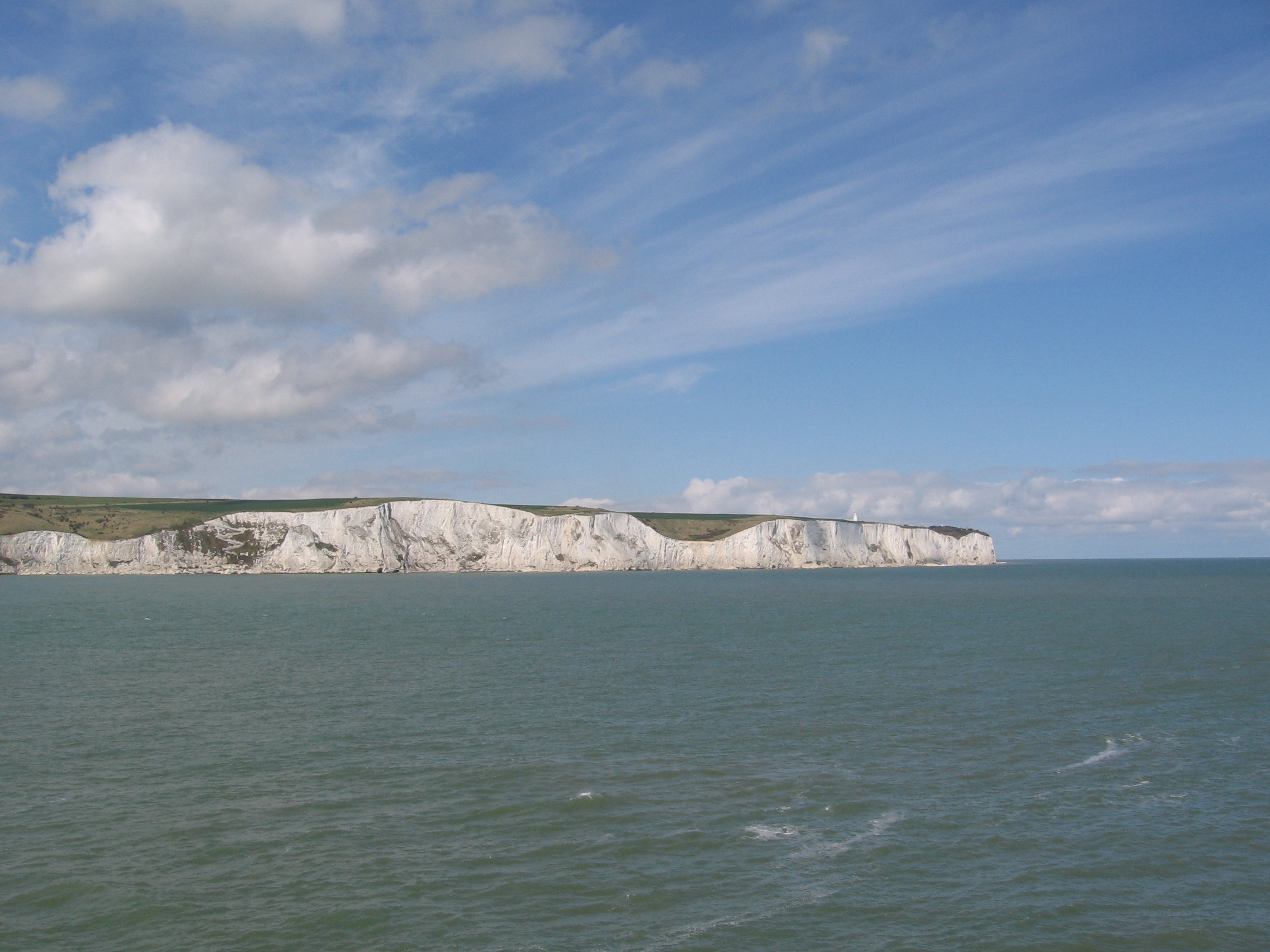
![The White Cliffs of Dover [1] The National Trust have a visitor centre with a shop and 300 car parking spaces on the top of the famous cliffs. The site offers fine views of the coast and Dover harbour.](https://s3.geograph.org.uk/geophotos/07/09/91/7099103_5a10e968.jpg)
Bere Wood is located at Grid Ref: TR3443 (Lat: 51.146385, Lng: 1.3461714)
Administrative County: Kent
District: Dover
Police Authority: Kent
What 3 Words
///pixel.wedge.signified. Near Dover, Kent
Nearby Locations
Related Wikis

RAF Swingate Down
Royal Air Force Swingate Down or more simply RAF Swingate Down is a former Royal Air Force Chain Home Low radar station operational during the Second World...
Swingate Mill, Guston
Swingate Mill is a Grade II listed tower mill in Guston, Kent, England that was built in 1849. == History == Swingate Mill was built for John Mummery in...

West Cliffe
West Cliffe or Westcliffe is a village and former civil parish, now in the parish of St. Margaret's At Cliffe, in the Dover district, in east Kent, England...

Swingate transmitting station
The Swingate transmitting station is a facility for FM-transmission in the village of Swingate, near Dover, Kent (grid reference TR334429). For many years...
Swingate, Kent
Swingate is a village near Dover in Kent, England. The population of the village is included in the civil parish of Sutton. == See also == Swingate transmitting...
Langdon Bay (Kent)
Langdon Bay is a bay in east Kent, England. It is two miles east of the town of Dover, and is named after the nearby villages of Langdon, East Langdon...

Fan Bay Deep Shelter
Fan Bay Deep Shelter is a series of tunnels constructed during World War II as accommodation for Fan Bay Battery artillery battery, 23 metres down in the...
Duke of York's Royal Military School
The Duke of York's Royal Military School, more commonly known as the Duke of York's, is a co-educational academy (for students aged 11 to 18) with military...
Nearby Amenities
Located within 500m of 51.146385,1.3461714Have you been to Bere Wood?
Leave your review of Bere Wood below (or comments, questions and feedback).