Bulmer Coppice

Wood, Forest in Norfolk Broadland

England

Bulmer Coppice

Atlantic Avenue Part of an expansion of Norwich to the northeast.
Atlantic Avenue Credit: Hugh Venables

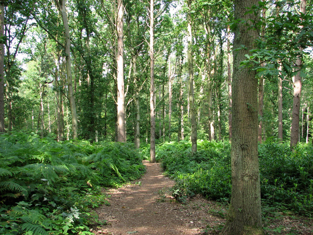
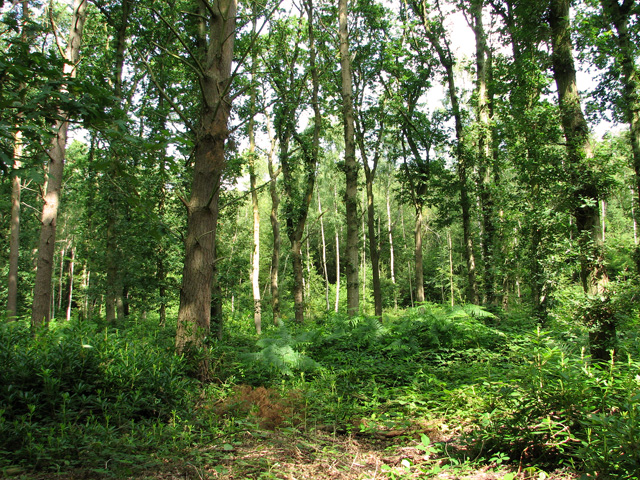
Bulmer Coppice is a picturesque woodland located in the county of Norfolk, England. Situated near the village of Bulmer, this ancient forest covers an area of approximately 100 acres and is part of the wider Norfolk Broads National Park.

The coppice is predominantly composed of native broadleaf trees, including oak, ash, birch, and beech, which create a diverse and vibrant ecosystem. The forest floor is rich in biodiversity, with a variety of wildflowers, ferns, and mosses thriving beneath the dense canopy.

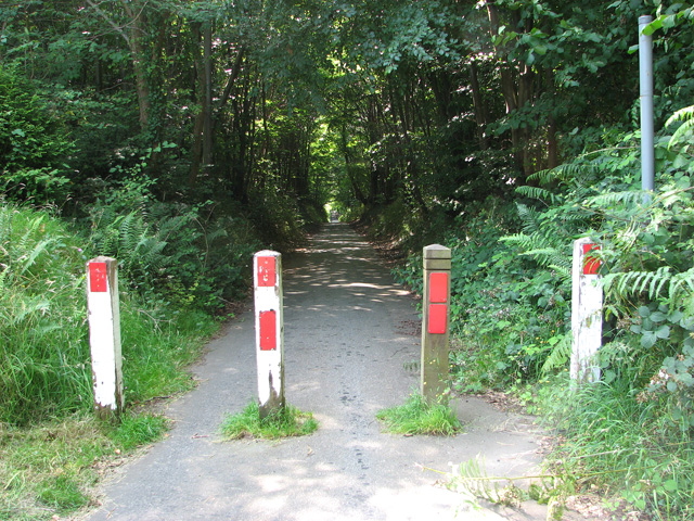
The woodland is crisscrossed by a network of well-maintained footpaths, allowing visitors to explore its natural beauty while immersing themselves in the tranquil surroundings. These paths lead to a small pond nestled within the forest, providing a peaceful spot for wildlife observation or a moment of reflection.

Bulmer Coppice is a haven for wildlife, offering a sanctuary for a range of species. Birdwatchers can spot woodpeckers, owls, and various songbirds flitting through the trees, while small mammals like squirrels and rabbits scurry about on the forest floor.

The woodland is open to the public throughout the year, and its serene atmosphere makes it an ideal destination for nature lovers, walkers, and those seeking a break from the hustle and bustle of everyday life. Whether it's a leisurely stroll through the trees, a picnic by the pond, or simply enjoying the sights and sounds of nature, Bulmer Coppice offers a truly idyllic experience for visitors of all ages.

If you have any feedback on the listing, please let us know in the comments section below.

Bulmer Coppice Images

Images are sourced within 2km of 52.657045/1.3602366 or Grid Reference TG2711. Thanks to Geograph Open Source API. All images are credited.

Atlantic Avenue Part of an expansion of Norwich to the northeast.
Atlantic Avenue
Part of an expansion of Norwich to the northeast.
Cycle path closed by Broadland Northway The cyclepath doesn't follow the length of the new road, just stretches where roads have been cut off.
Cycle path closed by Broadland Northway
The cyclepath doesn't follow the length of the new road, just stretches where roads have been cut off.
New part of New Rackheath Large housing development between the existing village and new dual carriageway.
New part of New Rackheath
Large housing development between the existing village and new dual carriageway.
Pound Lane past Belmore Plantation, Thorpe St Andrew Belmore Plantation is one of three woodlands (Racecourse, Belmore and Brown’s Plantations) in Thorpe St Andrew, just outside Norwich. Their total area is 205 acres (82 hectares), and together they form the largest area of woodland within several miles of Norwich. The woodlands are owned by the Thorpe & Felthorpe Trust, the Trustees of which are five members of the Gurney family. Local residents are opposing a developer's plan to build 631 housing 'units' here.
Pound Lane past Belmore Plantation, Thorpe St Andrew
Belmore Plantation is one of three woodlands (Racecourse, Belmore and Brown’s Plantations) in Thorpe St Andrew, just outside Norwich. Their total area is 205 acres (82 hectares), and together they form the largest area of woodland within several miles of Norwich. The woodlands are owned by the Thorpe & Felthorpe Trust, the Trustees of which are five members of the Gurney family. Local residents are opposing a developer's plan to build 631 housing 'units' here.
Belmore Plantation as seen from Pound Lane, Thorpe St Andrew Belmore Plantation is one of three woodlands (Racecourse, Belmore and Brown’s Plantations) in Thorpe St Andrew, just outside Norwich. Their total area is 205 acres (82 hectares), and together they form the largest area of woodland within several miles of Norwich. The woodlands are owned by the Thorpe & Felthorpe Trust, the Trustees of which are five members of the Gurney family. Local residents are opposing a developer's plan to build 631 housing 'units' here.
Belmore Plantation as seen from Pound Lane, Thorpe St Andrew
Belmore Plantation is one of three woodlands (Racecourse, Belmore and Brown’s Plantations) in Thorpe St Andrew, just outside Norwich. Their total area is 205 acres (82 hectares), and together they form the largest area of woodland within several miles of Norwich. The woodlands are owned by the Thorpe & Felthorpe Trust, the Trustees of which are five members of the Gurney family. Local residents are opposing a developer's plan to build 631 housing 'units' here.
Cottages in Pound Lane, Thorpe St Andrew
Cottages on the edge of Belmore Plantation, Thorpe St Andrew The tree in the foreground (right) is a large redwood tree. The term 'redwood' generally refers to one of several species of tree with red or reddish coloured wood; the bark of mature trees is commonly orange to red-brown in colour and of a stringy texture. Redwoods are conifers of the Cupressaceae or cypress family that has a worldwide distribution ranging from arctic Norway to southern Chile.

Belmore Plantation is one of three woodlands (Racecourse, Belmore and Brown’s Plantations) in Thorpe St Andrew, just outside Norwich. Their total area is 205 acres (82 hectares), and together they form the largest area of woodland within several miles of Norwich. The woodlands are owned by the Thorpe & Felthorpe Trust, the Trustees of which are five members of the Gurney family. Local residents are opposing a developer's plan to build 631 housing 'units' here.
Cottages on the edge of Belmore Plantation, Thorpe St Andrew
The tree in the foreground (right) is a large redwood tree. The term 'redwood' generally refers to one of several species of tree with red or reddish coloured wood; the bark of mature trees is commonly orange to red-brown in colour and of a stringy texture. Redwoods are conifers of the Cupressaceae or cypress family that has a worldwide distribution ranging from arctic Norway to southern Chile. Belmore Plantation is one of three woodlands (Racecourse, Belmore and Brown’s Plantations) in Thorpe St Andrew, just outside Norwich. Their total area is 205 acres (82 hectares), and together they form the largest area of woodland within several miles of Norwich. The woodlands are owned by the Thorpe & Felthorpe Trust, the Trustees of which are five members of the Gurney family. Local residents are opposing a developer's plan to build 631 housing 'units' here.
Redwood tree on the edge of Belmore Plantation, Thorpe St Andrew In a class of its own and standing out from the surrounding broadleaf trees this large redwood tree is growing on the edge of Belmore Plantation. The term 'redwood' generally refers to one of several species of tree with red or reddish coloured wood; the bark of mature trees is commonly orange to red-brown in colour and of a stringy texture. Redwoods are conifers of the Cupressaceae or cypress family that has a worldwide distribution ranging from arctic Norway to southern Chile.

Belmore Plantation is one of three woodlands (Racecourse, Belmore and Brown’s Plantations) in Thorpe St Andrew, just outside Norwich. Their total area is 205 acres (82 hectares), and together they form the largest area of woodland within several miles of Norwich. The woodlands are owned by the Thorpe & Felthorpe Trust, the Trustees of which are five members of the Gurney family. Local residents are opposing a developer's plan to build 631 housing 'units' here.
Redwood tree on the edge of Belmore Plantation, Thorpe St Andrew
In a class of its own and standing out from the surrounding broadleaf trees this large redwood tree is growing on the edge of Belmore Plantation. The term 'redwood' generally refers to one of several species of tree with red or reddish coloured wood; the bark of mature trees is commonly orange to red-brown in colour and of a stringy texture. Redwoods are conifers of the Cupressaceae or cypress family that has a worldwide distribution ranging from arctic Norway to southern Chile. Belmore Plantation is one of three woodlands (Racecourse, Belmore and Brown’s Plantations) in Thorpe St Andrew, just outside Norwich. Their total area is 205 acres (82 hectares), and together they form the largest area of woodland within several miles of Norwich. The woodlands are owned by the Thorpe & Felthorpe Trust, the Trustees of which are five members of the Gurney family. Local residents are opposing a developer's plan to build 631 housing 'units' here.
Dry pond in Belmore Plantation, Thorpe St Andrew Belmore Plantation is one of three woodlands (Racecourse, Belmore and Brown’s Plantations) in Thorpe St Andrew, just outside Norwich. Their total area is 205 acres (82 hectares), and together they form the largest area of woodland within several miles of Norwich. The woodlands are owned by the Thorpe & Felthorpe Trust, the Trustees of which are five members of the Gurney family. Local residents are opposing a developer's plan to build 631 housing 'units' here.
Dry pond in Belmore Plantation, Thorpe St Andrew
Belmore Plantation is one of three woodlands (Racecourse, Belmore and Brown’s Plantations) in Thorpe St Andrew, just outside Norwich. Their total area is 205 acres (82 hectares), and together they form the largest area of woodland within several miles of Norwich. The woodlands are owned by the Thorpe & Felthorpe Trust, the Trustees of which are five members of the Gurney family. Local residents are opposing a developer's plan to build 631 housing 'units' here.
Path past ponds in Belmore Plantation, Thorpe St Andrew Belmore Plantation is one of three woodlands (Racecourse, Belmore and Brown’s Plantations) in Thorpe St Andrew, just outside Norwich. Their total area is 205 acres (82 hectares), and together they form the largest area of woodland within several miles of Norwich. The woodlands are owned by the Thorpe & Felthorpe Trust, the Trustees of which are five members of the Gurney family. Local residents are opposing a developer's plan to build 631 housing 'units' here.
Path past ponds in Belmore Plantation, Thorpe St Andrew
Belmore Plantation is one of three woodlands (Racecourse, Belmore and Brown’s Plantations) in Thorpe St Andrew, just outside Norwich. Their total area is 205 acres (82 hectares), and together they form the largest area of woodland within several miles of Norwich. The woodlands are owned by the Thorpe & Felthorpe Trust, the Trustees of which are five members of the Gurney family. Local residents are opposing a developer's plan to build 631 housing 'units' here.
Path in Belmore Plantation, Thorpe St Andrew Belmore Plantation is one of three woodlands (Racecourse, Belmore and Brown’s Plantations) in Thorpe St Andrew, just outside Norwich. Their total area is 205 acres (82 hectares), and together they form the largest area of woodland within several miles of Norwich. The woodlands are owned by the Thorpe & Felthorpe Trust, the Trustees of which are five members of the Gurney family. Local residents are opposing a developer's plan to build 631 housing 'units' here.
Path in Belmore Plantation, Thorpe St Andrew
Belmore Plantation is one of three woodlands (Racecourse, Belmore and Brown’s Plantations) in Thorpe St Andrew, just outside Norwich. Their total area is 205 acres (82 hectares), and together they form the largest area of woodland within several miles of Norwich. The woodlands are owned by the Thorpe & Felthorpe Trust, the Trustees of which are five members of the Gurney family. Local residents are opposing a developer's plan to build 631 housing 'units' here.
Pound Lane past Brown's Plantation, Thorpe St Andrew The woodland to the right (west) of the lane is Belmore Plantation. Belmore Plantation is one of three woodlands (Racecourse, Belmore and Brown’s Plantations) in Thorpe St Andrew, just outside Norwich. Their total area is 205 acres (82 hectares), and together they form the largest area of woodland within several miles of Norwich. The woodlands are owned by the Thorpe & Felthorpe Trust, the Trustees of which are five members of the Gurney family. Local residents are opposing a developer's plan to build 631 housing 'units' here.
Pound Lane past Brown's Plantation, Thorpe St Andrew
The woodland to the right (west) of the lane is Belmore Plantation. Belmore Plantation is one of three woodlands (Racecourse, Belmore and Brown’s Plantations) in Thorpe St Andrew, just outside Norwich. Their total area is 205 acres (82 hectares), and together they form the largest area of woodland within several miles of Norwich. The woodlands are owned by the Thorpe & Felthorpe Trust, the Trustees of which are five members of the Gurney family. Local residents are opposing a developer's plan to build 631 housing 'units' here.
The northern end of Pound Lane, Thorpe St Andrew
Bungalows by the southern edge of Belmore Plantation, Thorpe St Andrew
Path through bracken in Belmore Plantation, Thorpe St Andrew Belmore Plantation is one of three woodlands (Racecourse, Belmore and Brown’s Plantations) in Thorpe St Andrew, just outside Norwich. Their total area is 205 acres (82 hectares), and together they form the largest area of woodland within several miles of Norwich. The woodlands are owned by the Thorpe & Felthorpe Trust, the Trustees of which are five members of the Gurney family. Local residents are opposing a developer's plan to build 631 housing 'units' here.
Path through bracken in Belmore Plantation, Thorpe St Andrew
Belmore Plantation is one of three woodlands (Racecourse, Belmore and Brown’s Plantations) in Thorpe St Andrew, just outside Norwich. Their total area is 205 acres (82 hectares), and together they form the largest area of woodland within several miles of Norwich. The woodlands are owned by the Thorpe & Felthorpe Trust, the Trustees of which are five members of the Gurney family. Local residents are opposing a developer's plan to build 631 housing 'units' here.
Belmore Plantation, Thorpe St Andrew Belmore Plantation is one of three woodlands (Racecourse, Belmore and Brown’s Plantations) in Thorpe St Andrew, just outside Norwich. Their total area is 205 acres (82 hectares), and together they form the largest area of woodland within several miles of Norwich. The woodlands are owned by the Thorpe & Felthorpe Trust, the Trustees of which are five members of the Gurney family. Local residents are opposing a developer's plan to build 631 housing 'units' here.
Belmore Plantation, Thorpe St Andrew
Belmore Plantation is one of three woodlands (Racecourse, Belmore and Brown’s Plantations) in Thorpe St Andrew, just outside Norwich. Their total area is 205 acres (82 hectares), and together they form the largest area of woodland within several miles of Norwich. The woodlands are owned by the Thorpe & Felthorpe Trust, the Trustees of which are five members of the Gurney family. Local residents are opposing a developer's plan to build 631 housing 'units' here.
Cottages in South Hill Road, Thorpe St Andrew
Show me another place!

Bulmer Coppice is located at Grid Ref: TG2711 (Lat: 52.657045, Lng: 1.3602366)

Administrative County: Norfolk

District: Broadland

Police Authority: Norfolk

What 3 Words

///newly.reap.ropes. Near Rackheath, Norfolk

Nearby Locations

Bulmer Coppice

Related Wikis

Norwich Northern Distributor Road

The Norwich Northern Distributor Road, now officially named the Broadland Northway (but also known as the NDR) is a 12.4 mi (20.0 km) dual-carriageway...
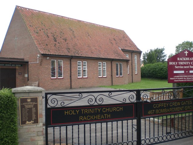
Rackheath

Rackheath is a village and civil parish in the English county of Norfolk, and is roughly 6 miles (9.7 km) north-east of Norwich city centre. It covers...

RAF Rackheath

Royal Air Force Rackheath, more commonly known as RAF Rackheath, is a former Royal Air Force station located near the village of Rackheath, approximately...

RAF Mousehold Heath

The area of Norwich between the Salhouse and Plumstead roads (outside of the outer ring road) was originally the Cavalry Training Ground and then became...

Nearby Amenities

Located within 500m of 52.657045,1.3602366
Bus Stop
South Lodges, adj
Naptan AtcoCode: 2900S3861
Naptan Bearing: NE
Naptan BusStopType: CUS
Naptan CommonName: South Lodges
Naptan Indicator: adj
Naptan Landmark: South Lodges
Naptan Locality: New Rackheath
Naptan NaptanCode: nfogpdpt
Naptan PlusbusZoneRef: NRCH
Naptan Street: Salhouse Road
Naptan Verified: no
Shelter: no
Source: naptan_import
Lat/Long: 52.6574906/1.3667128
Bus Stop
South Lodges, opp
Bench: no
Check Date Shelter: 2021-05-03
Naptan AtcoCode: 2900S3862
Naptan Bearing: SW
Naptan BusStopType: CUS
Naptan CommonName: South Lodges
Naptan Indicator: opp
Naptan Landmark: South Lodges
Naptan Locality: New Rackheath
Naptan NaptanCode: nfogpdpw
Naptan PlusbusZoneRef: NRCH
Naptan Street: Salhouse Road
Naptan Verified: no
Shelter: no
Source: naptan_import
Tactile Paving: no
Lat/Long: 52.6573428/1.3668493
Source: OS_OpenData_VectorMapLocal
Lat/Long: 52.6529429/1.3631709
Source: OS_OpenData_VectorMapLocal
Lat/Long: 52.6529954/1.3631256
Source: OS_OpenData_VectorMapLocal
Lat/Long: 52.6529587/1.3630106
Source: OS_OpenData_VectorMapLocal
Lat/Long: 52.6529063/1.3630558
The data included in this document is from www.openstreetmap.org. The data is made available under ODbL.

Have you been to Bulmer Coppice?

Leave your review of Bulmer Coppice below (or comments, questions and feedback).