Harrison's Plantation

Wood, Forest in Norfolk Broadland

England

Harrison's Plantation

Gurney Road through Mousehold Heath
Gurney Road through Mousehold Heath Credit: Hugh Venables

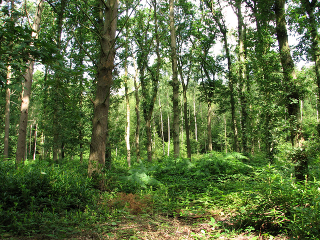
Harrison's Plantation, located in Norfolk, is a sprawling woodland area known for its abundant vegetation and serene atmosphere. This picturesque plantation covers a vast expanse of land and is a popular destination for nature enthusiasts and those seeking tranquility amidst the bustling city.

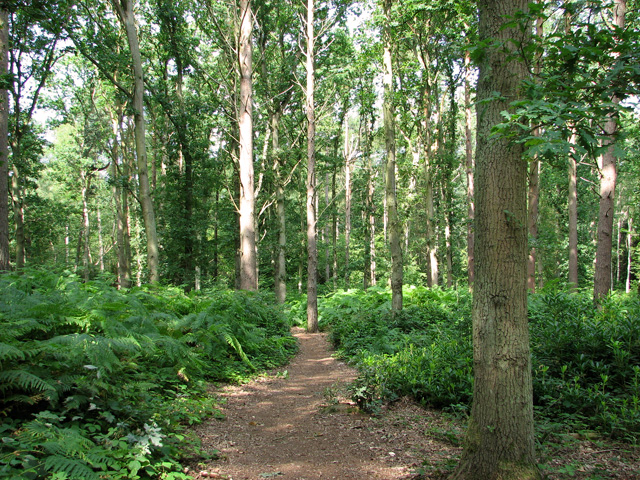
The plantation is dominated by a variety of tree species, including oak, pine, and maple, which create a dense and vibrant forest canopy. The diverse range of flora found within Harrison's Plantation supports a thriving ecosystem, attracting a wide array of wildlife. Visitors often spot deer, rabbits, and various bird species during their exploration of the area.

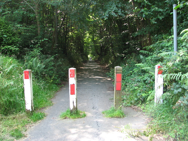
Trails wind through the plantation, allowing visitors to immerse themselves in the natural beauty that surrounds them. The pathways are well-maintained, providing hikers with ease of access and a chance to admire the stunning scenery. Along the trails, there are designated picnic areas where visitors can relax and enjoy a meal amidst the tranquil surroundings.

Harrison's Plantation also features a small lake, nestled within the forest, offering visitors an opportunity for fishing and boating. The lake is teeming with fish, making it a popular spot for anglers of all skill levels.

The plantation is a haven for nature photographers, offering countless opportunities to capture breathtaking shots of the flora and fauna. The changing seasons bring unique colors and textures to the landscape, making it an ever-changing canvas for creativity.

Overall, Harrison's Plantation is a hidden gem within Norfolk, providing a sanctuary for those seeking solace in nature. Its rich biodiversity, well-maintained trails, and peaceful ambiance make it a must-visit destination for anyone looking to reconnect with the great outdoors.

If you have any feedback on the listing, please let us know in the comments section below.

Harrison's Plantation Images

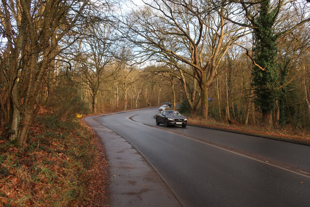
Images are sourced within 2km of 52.652395/1.342444 or Grid Reference TG2611. Thanks to Geograph Open Source API. All images are credited.

Gurney Road through Mousehold Heath
Atlantic Avenue Part of an expansion of Norwich to the northeast.
Atlantic Avenue
Part of an expansion of Norwich to the northeast.
Works at Sprowston Retail Park
Offices, Sprowston Hidden away on an industrial estate is a novel-looking office block built for British Gas "utilizing the German Burolandschaft concept, whereby the first floor is open-plan while the ground floor has areas divided by low partitions." Built in 1970-71 to the designs of the Design Group for Industry.
Now known as Sapphire House. It's not clear to what extent the internal layout has survived.
Offices, Sprowston
Hidden away on an industrial estate is a novel-looking office block built for British Gas "utilizing the German Burolandschaft concept, whereby the first floor is open-plan while the ground floor has areas divided by low partitions." Built in 1970-71 to the designs of the Design Group for Industry. Now known as Sapphire House. It's not clear to what extent the internal layout has survived.
Police station, Sprowston On Wroxham Road. A period piece, 1950s neo-Georgian.
This may no longer be operational as police forces increasingly centralise facilities in order to keep costs down.
Police station, Sprowston
On Wroxham Road. A period piece, 1950s neo-Georgian. This may no longer be operational as police forces increasingly centralise facilities in order to keep costs down.
Pound Lane past Belmore Plantation, Thorpe St Andrew Belmore Plantation is one of three woodlands (Racecourse, Belmore and Brown’s Plantations) in Thorpe St Andrew, just outside Norwich. Their total area is 205 acres (82 hectares), and together they form the largest area of woodland within several miles of Norwich. The woodlands are owned by the Thorpe & Felthorpe Trust, the Trustees of which are five members of the Gurney family. Local residents are opposing a developer's plan to build 631 housing 'units' here.
Pound Lane past Belmore Plantation, Thorpe St Andrew
Belmore Plantation is one of three woodlands (Racecourse, Belmore and Brown’s Plantations) in Thorpe St Andrew, just outside Norwich. Their total area is 205 acres (82 hectares), and together they form the largest area of woodland within several miles of Norwich. The woodlands are owned by the Thorpe & Felthorpe Trust, the Trustees of which are five members of the Gurney family. Local residents are opposing a developer's plan to build 631 housing 'units' here.
Belmore Plantation as seen from Pound Lane, Thorpe St Andrew Belmore Plantation is one of three woodlands (Racecourse, Belmore and Brown’s Plantations) in Thorpe St Andrew, just outside Norwich. Their total area is 205 acres (82 hectares), and together they form the largest area of woodland within several miles of Norwich. The woodlands are owned by the Thorpe & Felthorpe Trust, the Trustees of which are five members of the Gurney family. Local residents are opposing a developer's plan to build 631 housing 'units' here.
Belmore Plantation as seen from Pound Lane, Thorpe St Andrew
Belmore Plantation is one of three woodlands (Racecourse, Belmore and Brown’s Plantations) in Thorpe St Andrew, just outside Norwich. Their total area is 205 acres (82 hectares), and together they form the largest area of woodland within several miles of Norwich. The woodlands are owned by the Thorpe & Felthorpe Trust, the Trustees of which are five members of the Gurney family. Local residents are opposing a developer's plan to build 631 housing 'units' here.
Cottages in Pound Lane, Thorpe St Andrew
Cottages on the edge of Belmore Plantation, Thorpe St Andrew The tree in the foreground (right) is a large redwood tree. The term 'redwood' generally refers to one of several species of tree with red or reddish coloured wood; the bark of mature trees is commonly orange to red-brown in colour and of a stringy texture. Redwoods are conifers of the Cupressaceae or cypress family that has a worldwide distribution ranging from arctic Norway to southern Chile.

Belmore Plantation is one of three woodlands (Racecourse, Belmore and Brown’s Plantations) in Thorpe St Andrew, just outside Norwich. Their total area is 205 acres (82 hectares), and together they form the largest area of woodland within several miles of Norwich. The woodlands are owned by the Thorpe & Felthorpe Trust, the Trustees of which are five members of the Gurney family. Local residents are opposing a developer's plan to build 631 housing 'units' here.
Cottages on the edge of Belmore Plantation, Thorpe St Andrew
The tree in the foreground (right) is a large redwood tree. The term 'redwood' generally refers to one of several species of tree with red or reddish coloured wood; the bark of mature trees is commonly orange to red-brown in colour and of a stringy texture. Redwoods are conifers of the Cupressaceae or cypress family that has a worldwide distribution ranging from arctic Norway to southern Chile. Belmore Plantation is one of three woodlands (Racecourse, Belmore and Brown’s Plantations) in Thorpe St Andrew, just outside Norwich. Their total area is 205 acres (82 hectares), and together they form the largest area of woodland within several miles of Norwich. The woodlands are owned by the Thorpe & Felthorpe Trust, the Trustees of which are five members of the Gurney family. Local residents are opposing a developer's plan to build 631 housing 'units' here.
Redwood tree on the edge of Belmore Plantation, Thorpe St Andrew In a class of its own and standing out from the surrounding broadleaf trees this large redwood tree is growing on the edge of Belmore Plantation. The term 'redwood' generally refers to one of several species of tree with red or reddish coloured wood; the bark of mature trees is commonly orange to red-brown in colour and of a stringy texture. Redwoods are conifers of the Cupressaceae or cypress family that has a worldwide distribution ranging from arctic Norway to southern Chile.

Belmore Plantation is one of three woodlands (Racecourse, Belmore and Brown’s Plantations) in Thorpe St Andrew, just outside Norwich. Their total area is 205 acres (82 hectares), and together they form the largest area of woodland within several miles of Norwich. The woodlands are owned by the Thorpe & Felthorpe Trust, the Trustees of which are five members of the Gurney family. Local residents are opposing a developer's plan to build 631 housing 'units' here.
Redwood tree on the edge of Belmore Plantation, Thorpe St Andrew
In a class of its own and standing out from the surrounding broadleaf trees this large redwood tree is growing on the edge of Belmore Plantation. The term 'redwood' generally refers to one of several species of tree with red or reddish coloured wood; the bark of mature trees is commonly orange to red-brown in colour and of a stringy texture. Redwoods are conifers of the Cupressaceae or cypress family that has a worldwide distribution ranging from arctic Norway to southern Chile. Belmore Plantation is one of three woodlands (Racecourse, Belmore and Brown’s Plantations) in Thorpe St Andrew, just outside Norwich. Their total area is 205 acres (82 hectares), and together they form the largest area of woodland within several miles of Norwich. The woodlands are owned by the Thorpe & Felthorpe Trust, the Trustees of which are five members of the Gurney family. Local residents are opposing a developer's plan to build 631 housing 'units' here.
Dry pond in Belmore Plantation, Thorpe St Andrew Belmore Plantation is one of three woodlands (Racecourse, Belmore and Brown’s Plantations) in Thorpe St Andrew, just outside Norwich. Their total area is 205 acres (82 hectares), and together they form the largest area of woodland within several miles of Norwich. The woodlands are owned by the Thorpe & Felthorpe Trust, the Trustees of which are five members of the Gurney family. Local residents are opposing a developer's plan to build 631 housing 'units' here.
Dry pond in Belmore Plantation, Thorpe St Andrew
Belmore Plantation is one of three woodlands (Racecourse, Belmore and Brown’s Plantations) in Thorpe St Andrew, just outside Norwich. Their total area is 205 acres (82 hectares), and together they form the largest area of woodland within several miles of Norwich. The woodlands are owned by the Thorpe & Felthorpe Trust, the Trustees of which are five members of the Gurney family. Local residents are opposing a developer's plan to build 631 housing 'units' here.
Path past ponds in Belmore Plantation, Thorpe St Andrew Belmore Plantation is one of three woodlands (Racecourse, Belmore and Brown’s Plantations) in Thorpe St Andrew, just outside Norwich. Their total area is 205 acres (82 hectares), and together they form the largest area of woodland within several miles of Norwich. The woodlands are owned by the Thorpe & Felthorpe Trust, the Trustees of which are five members of the Gurney family. Local residents are opposing a developer's plan to build 631 housing 'units' here.
Path past ponds in Belmore Plantation, Thorpe St Andrew
Belmore Plantation is one of three woodlands (Racecourse, Belmore and Brown’s Plantations) in Thorpe St Andrew, just outside Norwich. Their total area is 205 acres (82 hectares), and together they form the largest area of woodland within several miles of Norwich. The woodlands are owned by the Thorpe & Felthorpe Trust, the Trustees of which are five members of the Gurney family. Local residents are opposing a developer's plan to build 631 housing 'units' here.
Path in Belmore Plantation, Thorpe St Andrew Belmore Plantation is one of three woodlands (Racecourse, Belmore and Brown’s Plantations) in Thorpe St Andrew, just outside Norwich. Their total area is 205 acres (82 hectares), and together they form the largest area of woodland within several miles of Norwich. The woodlands are owned by the Thorpe & Felthorpe Trust, the Trustees of which are five members of the Gurney family. Local residents are opposing a developer's plan to build 631 housing 'units' here.
Path in Belmore Plantation, Thorpe St Andrew
Belmore Plantation is one of three woodlands (Racecourse, Belmore and Brown’s Plantations) in Thorpe St Andrew, just outside Norwich. Their total area is 205 acres (82 hectares), and together they form the largest area of woodland within several miles of Norwich. The woodlands are owned by the Thorpe & Felthorpe Trust, the Trustees of which are five members of the Gurney family. Local residents are opposing a developer's plan to build 631 housing 'units' here.
Pound Lane past Brown's Plantation, Thorpe St Andrew The woodland to the right (west) of the lane is Belmore Plantation. Belmore Plantation is one of three woodlands (Racecourse, Belmore and Brown’s Plantations) in Thorpe St Andrew, just outside Norwich. Their total area is 205 acres (82 hectares), and together they form the largest area of woodland within several miles of Norwich. The woodlands are owned by the Thorpe & Felthorpe Trust, the Trustees of which are five members of the Gurney family. Local residents are opposing a developer's plan to build 631 housing 'units' here.
Pound Lane past Brown's Plantation, Thorpe St Andrew
The woodland to the right (west) of the lane is Belmore Plantation. Belmore Plantation is one of three woodlands (Racecourse, Belmore and Brown’s Plantations) in Thorpe St Andrew, just outside Norwich. Their total area is 205 acres (82 hectares), and together they form the largest area of woodland within several miles of Norwich. The woodlands are owned by the Thorpe & Felthorpe Trust, the Trustees of which are five members of the Gurney family. Local residents are opposing a developer's plan to build 631 housing 'units' here.
The northern end of Pound Lane, Thorpe St Andrew
Bungalows by the southern edge of Belmore Plantation, Thorpe St Andrew
Path through bracken in Belmore Plantation, Thorpe St Andrew Belmore Plantation is one of three woodlands (Racecourse, Belmore and Brown’s Plantations) in Thorpe St Andrew, just outside Norwich. Their total area is 205 acres (82 hectares), and together they form the largest area of woodland within several miles of Norwich. The woodlands are owned by the Thorpe & Felthorpe Trust, the Trustees of which are five members of the Gurney family. Local residents are opposing a developer's plan to build 631 housing 'units' here.
Path through bracken in Belmore Plantation, Thorpe St Andrew
Belmore Plantation is one of three woodlands (Racecourse, Belmore and Brown’s Plantations) in Thorpe St Andrew, just outside Norwich. Their total area is 205 acres (82 hectares), and together they form the largest area of woodland within several miles of Norwich. The woodlands are owned by the Thorpe & Felthorpe Trust, the Trustees of which are five members of the Gurney family. Local residents are opposing a developer's plan to build 631 housing 'units' here.
Belmore Plantation, Thorpe St Andrew Belmore Plantation is one of three woodlands (Racecourse, Belmore and Brown’s Plantations) in Thorpe St Andrew, just outside Norwich. Their total area is 205 acres (82 hectares), and together they form the largest area of woodland within several miles of Norwich. The woodlands are owned by the Thorpe & Felthorpe Trust, the Trustees of which are five members of the Gurney family. Local residents are opposing a developer's plan to build 631 housing 'units' here.
Belmore Plantation, Thorpe St Andrew
Belmore Plantation is one of three woodlands (Racecourse, Belmore and Brown’s Plantations) in Thorpe St Andrew, just outside Norwich. Their total area is 205 acres (82 hectares), and together they form the largest area of woodland within several miles of Norwich. The woodlands are owned by the Thorpe & Felthorpe Trust, the Trustees of which are five members of the Gurney family. Local residents are opposing a developer's plan to build 631 housing 'units' here.
Show me another place!

Harrison's Plantation is located at Grid Ref: TG2611 (Lat: 52.652395, Lng: 1.342444)

Administrative County: Norfolk

District: Broadland

Police Authority: Norfolk

What 3 Words

///ended.firm.guilty. Near Rackheath, Norfolk

Related Wikis

RAF Mousehold Heath

The area of Norwich between the Salhouse and Plumstead roads (outside of the outer ring road) was originally the Cavalry Training Ground and then became...

Heartsease Estate, Norwich

The Heartsease is a housing estate located in Norwich, Norfolk and takes its name from the heartsease, a common European wild flower. == Location == The...

Sprowston Community Academy

Sprowston Community Academy is a coeducational secondary school located in Sprowston, Norwich, Norfolk, England. == Description == Ofsted visiting the...

Open Academy

Open Academy (formerly Heartsease High School) is a secondary school with academy status located in the Heartsease area of Norwich, in the English county...

Nearby Amenities

Located within 500m of 52.652395,1.342444
Traffic Signals
Lat/Long: 52.6496923/1.34061
Post Box
Collection Times: Mo-Fr 18:00; Sa 11:45
Operator: Royal Mail
Post Box Type: wall
Ref: NR7 732
Royal Cypher: EIIR
Royal Cypher Wikidata: Q33102113
Source: survey
Lat/Long: 52.6494115/1.340737
Turning Circle
Lat/Long: 52.6536171/1.3366514
Bus Stop
Sale Road, adj
Naptan AtcoCode: 2900N1215
Naptan Bearing: NW
Naptan CommonName: Sale Road
Naptan Indicator: adj
Naptan Landmark: Sale Road
Naptan Locality: Heartsease
Naptan NaptanCode: nfodjaga
Naptan PlusbusZoneRef: NRCH
Naptan ShortCommonName: Sale Road
Naptan Street: Sale Road
Naptan Verified: no
Source: naptan_import
Lat/Long: 52.648532/1.3397461
Pinetrees Road, opp
Naptan AtcoCode: 2900N12646
Naptan Bearing: SW
Naptan BusStopType: CUS
Naptan CommonName: Pinetrees Road
Naptan Indicator: opp
Naptan Landmark: Pinetrees Road
Naptan Locality: Heartsease
Naptan NaptanCode: nfodmjdj
Naptan PlusbusZoneRef: NRCH
Naptan Street: Salhouse Road
Naptan Verified: no
Source: naptan_import
Lat/Long: 52.6492687/1.3391368
Bus Stop
Greenborough Road, opp
Naptan AtcoCode: 2900S3820
Naptan Bearing: SW
Naptan CommonName: Greenborough Road
Naptan Indicator: opp
Naptan Landmark: Hammond Way
Naptan Locality: Heartsease
Naptan NaptanCode: nfodtpaw
Naptan PlusbusZoneRef: NRCH
Naptan ShortCommonName: Greenborough Road
Naptan Street: Greenborough Road
Naptan Verified: no
Source: naptan_import
Lat/Long: 52.6483302/1.3449803
BP Garage, opp
Naptan AtcoCode: 2900S3847
Naptan Bearing: SW
Naptan BusStopType: CUS
Naptan CommonName: BP Garage
Naptan Indicator: opp
Naptan Landmark: BP Garage
Naptan Locality: Heartsease
Naptan NaptanCode: nfodtpmt
Naptan PlusbusZoneRef: NRCH
Naptan Street: Salhouse Road
Naptan Verified: no
Source: naptan_import
Lat/Long: 52.6499016/1.341566
Hammond Way, adj
Naptan AtcoCode: 2900S3848
Naptan Bearing: NW
Naptan BusStopType: CUS
Naptan CommonName: Hammond Way
Naptan Indicator: adj
Naptan Landmark: No. 10
Naptan Locality: Heartsease
Naptan NaptanCode: nfodtpmw
Naptan PlusbusZoneRef: NRCH
Naptan ShortCommonName: Hammond Way
Naptan Street: Hammond Way
Naptan Verified: no
Source: naptan_import
Lat/Long: 52.6493162/1.3451
Breck Road, adj
Naptan AtcoCode: 2900S3850
Naptan Bearing: E
Naptan BusStopType: CUS
Naptan CommonName: Breck Road
Naptan Indicator: adj
Naptan Locality: Heartsease
Naptan NaptanCode: nfodtptd
Naptan PlusbusZoneRef: NRCH
Naptan ShortCommonName: Greenborough Road
Naptan Street: Greenborough Road
Naptan Verified: no
Source: naptan_import
Lat/Long: 52.6479788/1.3418185
BP Garage, adj
Naptan AtcoCode: 2900S3856
Naptan Bearing: NE
Naptan BusStopType: CUS
Naptan CommonName: BP Garage
Naptan Indicator: adj
Naptan Landmark: BP Garage
Naptan Locality: Heartsease
Naptan NaptanCode: nfodtpwa
Naptan PlusbusZoneRef: NRCH
Naptan Street: Salhouse Road
Naptan Verified: no
Source: naptan_import
Lat/Long: 52.6500484/1.3417842
Harrisons Drive, adj
Naptan AtcoCode: 2900S3857
Naptan Bearing: SW
Naptan BusStopType: CUS
Naptan CommonName: Harrisons Drive
Naptan Indicator: adj
Naptan Locality: Heartsease
Naptan NaptanCode: nfodtpwd
Naptan PlusbusZoneRef: NRCH
Naptan Street: Salhouse Road
Naptan Verified: no
Source: naptan_import
Lat/Long: 52.6512461/1.3466883
Harrisons Drive, opp
Naptan AtcoCode: 2900S3858
Naptan Bearing: NE
Naptan BusStopType: CUS
Naptan CommonName: Harrisons Drive
Naptan Indicator: opp
Naptan Locality: Heartsease
Naptan NaptanCode: nfodtpwg
Naptan PlusbusZoneRef: NRCH
Naptan Street: Salhouse Road
Naptan Verified: no
Source: naptan_import
Lat/Long: 52.6513542/1.3467703
Crossing
Crossing: traffic_signals
Crossing Ref: pelican
Tactile Paving: yes
Lat/Long: 52.6496125/1.3403093
Crossing
Crossing: traffic_signals
Crossing Ref: pelican
Tactile Paving: yes
Lat/Long: 52.6494731/1.3406511
Crossing
Crossing: unmarked
Crossing Island: yes
Tactile Paving: yes
Lat/Long: 52.6498891/1.3405746
Crossing
Crossing: island
Lat/Long: 52.6497599/1.3408549
Give Way
Lat/Long: 52.6498018/1.3449201
Turning Circle
Lat/Long: 52.650217/1.347825
Crossing
Crossing: uncontrolled
Lat/Long: 52.6527585/1.3352996
Turning Circle
Lat/Long: 52.65389/1.335889
Turning Circle
Lat/Long: 52.654251/1.335748
Recycling
Location: overground
Recycling Type: container
Lat/Long: 52.6556918/1.3396008
Crossing
Crossing: uncontrolled
Crossing Island: no
Crossing Ref: toucan
Tactile Paving: yes
Lat/Long: 52.6510162/1.3457532
Give Way
Lat/Long: 52.6497838/1.3448398
C J Ball
Addr Postcode: NR7 9AB
Addr Street: Salhouse Road
Shop: motorcycle
Website: https://www.cjball.co.uk/
Lat/Long: 52.6499968/1.3410487
Board Type: nature
Information: board
Tourism: information
Lat/Long: 52.6521342/1.340383
Board Type: nature
Information: board
Tourism: information
Lat/Long: 52.6519523/1.3399878
Addr Postcode: NR7 8SA
Building: yes
Lat/Long: 52.6556553/1.3422788
CrossFit Spitfire
Addr City: Norwich
Addr Housename: CrossFit Spitfire
Addr Housenumber: Unit 8, Caston Industrial Estate, 175
Addr Postcode: NR7 9AQ
Addr Street: Salhouse Road
Image: https://www.crossfitspitfire.com/wp-content/uploads/2020/08/ECEF0C33-28EF-4086-B231-E074287974BA-300x174.jpeg
Url: https://www.crossfitspitfire.com/
Lat/Long: 52.6494102/1.3376997
Defibrillator
Defibrillator Location: Mounted in box outside CrossFit Spitfire.
Emergency: defibrillator
Indoor: no
Ref GB The Circuit: AF5CDC8F-5D8C-4DD7-8E48-ADB1007FDD3B
Lat/Long: 52.6494499/1.3376943
Barrier: cycle_barrier
Lat/Long: 52.6546595/1.3371345
Waste Basket
Lat/Long: 52.6483741/1.3392192
Waste Basket
Colour: green
Material: plastic
Lat/Long: 52.6484811/1.3397919
The data included in this document is from www.openstreetmap.org. The data is made available under ODbL.

Have you been to Harrison's Plantation?

Leave your review of Harrison's Plantation below (or comments, questions and feedback).