Coronation Belt

Wood, Forest in Norfolk South Norfolk

England

Coronation Belt

Field headland A polished neolithic flint axe was found in this field in 1977 <a href="https://www.geograph.org.uk/photo/6946221">TG2605 : Neolithic polished flint axe</a>
Field headland Credit: Adrian S Pye

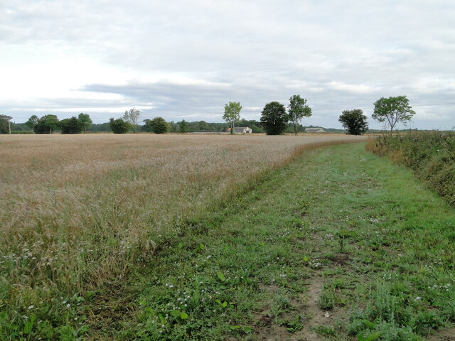
Coronation Belt, Norfolk is a picturesque area located in the eastern part of England. Nestled in the heart of the Norfolk countryside, this enchanting woodland boasts a rich history and diverse ecosystem. The belt is primarily made up of woodlands and forests, covering an expansive area of approximately 200 acres.

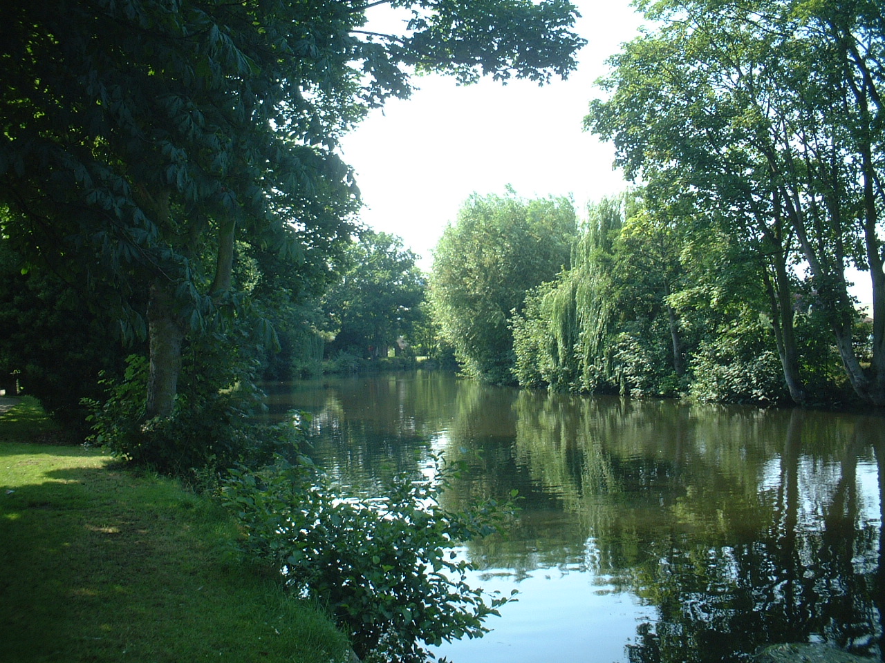
The dense canopy of trees in Coronation Belt offers a sanctuary for a wide variety of flora and fauna. Ancient oak, birch, and beech trees dominate the landscape, their majestic presence adding to the area's natural beauty. The forest floor is covered in a thick layer of moss, ferns, and wildflowers, creating a vibrant tapestry of colors throughout the seasons.

The woodlands of Coronation Belt have been carefully managed to preserve its unique biodiversity. The area is home to a range of wildlife, including deer, foxes, badgers, and numerous species of birds. Nature enthusiasts and birdwatchers flock to the area to catch a glimpse of rare and migratory species that inhabit the woodlands.

The tranquility and beauty of Coronation Belt make it a popular destination for outdoor activities such as hiking, walking, and photography. Numerous trails wind through the forest, allowing visitors to explore its hidden gems and discover its hidden charms. The area is also equipped with picnic spots and rest areas, providing a perfect setting for a peaceful day out in nature.

Whether it's the vibrant display of autumn colors, the soothing sounds of birdsong, or the peacefulness of a woodland walk, Coronation Belt offers a truly immersive natural experience for all who visit.

If you have any feedback on the listing, please let us know in the comments section below.

Coronation Belt Images

Images are sourced within 2km of 52.616775/1.3263402 or Grid Reference TG2507. Thanks to Geograph Open Source API. All images are credited.

Field headland A polished neolithic flint axe was found in this field in 1977 <a href="https://www.geograph.org.uk/photo/6946221">TG2605 : Neolithic polished flint axe</a>
Field headland
A polished neolithic flint axe was found in this field in 1977 TG2605 : Neolithic polished flint axe
William Kett Close, Gas Hill William Kett was a Norfolk farmer who in 1549 led a popular uprising in protest against the enclosure of commons by landowners.
The history is on <span class="nowrap"><a title="https://www.norfolk-norwich.com/news/ketts-rebellion.php" rel="nofollow ugc noopener" href="https://www.norfolk-norwich.com/news/ketts-rebellion.php">Link</a><img style="margin-left:2px;" alt="External link" title="External link - shift click to open in new window" src="https://s1.geograph.org.uk/img/external.png" width="10" height="10"/></span>
William Kett Close, Gas Hill
William Kett was a Norfolk farmer who in 1549 led a popular uprising in protest against the enclosure of commons by landowners. The history is on LinkExternal link
River Wensum with Boat and Pub A river cruiser moored outside a pub. A frequent sight on the waterways.
River Wensum with Boat and Pub
A river cruiser moored outside a pub. A frequent sight on the waterways.
Kings on the Corner Kings & Co, estate agents, occupy the ground floor of one of the new buildings which have replaced old industrial premises along here.
Kings on the Corner
Kings & Co, estate agents, occupy the ground floor of one of the new buildings which have replaced old industrial premises along here.
Old and New by the River The River Wensum heads out of Norwich through a former industrial area. On this side, an extensive redevelopment zone is full of new building, but on the other side is the old Colmans Mustard factory where mustard was made for 160 years before production stopped in 2020. 
Colmans Mustard is now made outside the city in a new mill.
Old and New by the River
The River Wensum heads out of Norwich through a former industrial area. On this side, an extensive redevelopment zone is full of new building, but on the other side is the old Colmans Mustard factory where mustard was made for 160 years before production stopped in 2020. Colmans Mustard is now made outside the city in a new mill.
Stadium Car Park Outside Norwich City's Carrow Road Football Ground.
Stadium Car Park
Outside Norwich City's Carrow Road Football Ground.
New Buildings, Geoffrey Watling Way A large area of old industrial buildings is being redeveloped.
Geoffrey Watling was a Norwich businessman and philanthropist, and also former president and chairman of Norwich City football club, whose stadium is a short way behind me.
New Buildings, Geoffrey Watling Way
A large area of old industrial buildings is being redeveloped. Geoffrey Watling was a Norwich businessman and philanthropist, and also former president and chairman of Norwich City football club, whose stadium is a short way behind me.
Building Site, Geoffrey Watling Way Redevelopment of former industrial land near the river.
Building Site, Geoffrey Watling Way
Redevelopment of former industrial land near the river.
Old Factory by the River Industrial buildings by the River Wensum.
Colman's Mustard was made here for 160 years up to 2020 when production moved to a new out of town site.
Old Factory by the River
Industrial buildings by the River Wensum. Colman's Mustard was made here for 160 years up to 2020 when production moved to a new out of town site.
River Wensum from the Novi Sad Bridge Some of the new riverside housing which has been built in a former run down industrial area.
River Wensum from the Novi Sad Bridge
Some of the new riverside housing which has been built in a former run down industrial area.
GoGoDiscover #18 Where's Rexy? Artist Ryan Newell. A landscape full of stylised dinosaurs from various time periods. Wherry Road.
GoGoDiscover #18 Where's Rexy?
Artist Ryan Newell. A landscape full of stylised dinosaurs from various time periods. Wherry Road.
Norwich Station An imposing building in the town centre. Some passengers were posing for photographs. Norwich is the terminus for intercity traffic using London Liverpool Street Station.
Norwich Station
An imposing building in the town centre. Some passengers were posing for photographs. Norwich is the terminus for intercity traffic using London Liverpool Street Station.
Pull’s Ferry Named after the ferryman, John Pull, who operated the service across the River Wensum for 45 years up to 1841.
Pull’s Ferry
Named after the ferryman, John Pull, who operated the service across the River Wensum for 45 years up to 1841.
Carrow Bridge The 98-year-old Carrow Bridge can be lifted to let boats pass on the Wensum. Securing it in a closed position was proposed due to the high cost of maintenance but that would prevent the use of the river. A resolution is still to be agreed. For information about the round tower on the riverbank, see <a href="https://www.geograph.org.uk/photo/177643">TG2307 : Boom Towers, Norwich</a>
Carrow Bridge
The 98-year-old Carrow Bridge can be lifted to let boats pass on the Wensum. Securing it in a closed position was proposed due to the high cost of maintenance but that would prevent the use of the river. A resolution is still to be agreed. For information about the round tower on the riverbank, see TG2307 : Boom Towers, Norwich
Carrow Road Football Ground Norwich City Football Club, the home of The Canaries, viewed looking toward the South Stand.
Carrow Road Football Ground
Norwich City Football Club, the home of The Canaries, viewed looking toward the South Stand.
New homes in central Norwich New blocks of flats on Geoffrey Watling Way using former industrial land. More building work is already under way.
New homes in central Norwich
New blocks of flats on Geoffrey Watling Way using former industrial land. More building work is already under way.
Norwich Mail Centre The Royal Mail building on Thorpe Road, the A1242.
Norwich Mail Centre
The Royal Mail building on Thorpe Road, the A1242.
Platform view Looking between the ironwork colonnades on platforms 3 and 4.
Platform view
Looking between the ironwork colonnades on platforms 3 and 4.
Show me another place!

Coronation Belt is located at Grid Ref: TG2507 (Lat: 52.616775, Lng: 1.3263402)

Administrative County: Norfolk

District: South Norfolk

Police Authority: Norfolk

What 3 Words

///pint.edge.chip. Near Thorpe Hamlet, Norfolk

Related Wikis

Norwich Rowing Club

Norwich Rowing Club is a rowing club on the River Yare based at Whitlingham Boathouses, Whitlingham Lane, Trowse, Norwich and is affiliated to British...

River Wensum

The River Wensum is a chalk river in Norfolk, England and a tributary of the River Yare, despite being the larger of the two rivers. The river is a biological...

Trowse

Trowse (pronounced by those from Norwich and by elderly residents of the village), also called Trowse with Newton, is a village in South Norfolk which...

Norwich power stations

The Norwich power stations were a sequence of electricity generating stations that provided electric power to the City of Norwich and the wider area between...

Nearby Amenities

Located within 500m of 52.616775,1.3263402
Power: pole
Lat/Long: 52.6189088/1.320047
Power: pole
Lat/Long: 52.6190359/1.3200482
Power: pole
Lat/Long: 52.6191904/1.3207011
Power: pole
Lat/Long: 52.619338/1.320726
Power: pole
Lat/Long: 52.6198502/1.321931
Power: pole
Lat/Long: 52.6197598/1.3219979
Power: pole
Lat/Long: 52.6203803/1.3231052
Power: pole
Lat/Long: 52.6202868/1.3231696
Crossing
Crossing: uncontrolled
Lat/Long: 52.6206466/1.3285827
Bench
Backrest: no
Colour: brown
Material: wood
Seats: 4
Lat/Long: 52.6159638/1.3202315
Barrier: stile
Foot: yes
Lat/Long: 52.6205719/1.3286316
Traffic Calming: hump
Lat/Long: 52.6198127/1.3265113
Traffic Calming: hump
Lat/Long: 52.6207529/1.3289626
HP Gas
Pipeline: marker
Type: gas
Lat/Long: 52.6178475/1.3301404
Pipeline: marker
Lat/Long: 52.6206193/1.3286783
Leisure: slipway
Lat/Long: 52.620448/1.3225018
Restaurant
Opening Hours: Mo-Th 18:00-23:00; Fr 17:00-23:00; Sa 09:00-19:00; Su 09:30-21:00
Lat/Long: 52.6147926/1.3206983
Norwich Canoe Club
Addr City: Norwich
Addr Housename: Whitlingham Boat House
Addr Postcode: NR14 8TR
Addr Street: Whitlingham Lane
Attraction: river_rafting
Website: https://www.norwichcanoeclub.co.uk/
Wheelchair: yes
Lat/Long: 52.6205125/1.3232003
Waste Basket
Waste: dog_excrement
Lat/Long: 52.6145809/1.3289491
Barrier: bollard
Bicycle: yes
Foot: yes
Horse: yes
Material: metal
Lat/Long: 52.6194265/1.3239464
The data included in this document is from www.openstreetmap.org. The data is made available under ODbL.

Have you been to Coronation Belt?

Leave your review of Coronation Belt below (or comments, questions and feedback).