Fring

Settlement in Norfolk King's Lynn and West Norfolk

England

Fring

Farm track near Fring
Farm track near Fring Credit: Jonathan Thacker

Fring is a small village located in the county of Norfolk, England. Situated just five miles north of King's Lynn, it is a picturesque and rural community surrounded by beautiful countryside. The village covers an area of approximately 4 square kilometers and has a population of around 200 residents.

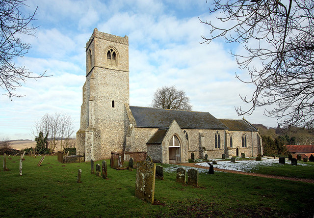
Fring is known for its charming and idyllic setting, with rolling hills, vast fields, and quaint cottages dotting the landscape. The village is predominantly residential, with a few local businesses and amenities catering to the needs of the community. The village church, St. Mary's, stands as a historic landmark and a focal point for local religious activities.

Although small in size, Fring offers a close-knit community atmosphere where residents are known for their friendliness and hospitality. The village has a strong sense of community spirit, with regular social events and gatherings organized throughout the year.

Fring benefits from its proximity to the Norfolk coast, which is just a short drive away. This allows residents and visitors to easily access the beautiful beaches and enjoy various seaside activities. Additionally, the village is surrounded by nature reserves, providing opportunities for outdoor enthusiasts to explore and enjoy the local flora and fauna.

Overall, Fring is a tranquil and scenic village in Norfolk, offering residents and visitors a peaceful retreat from the hustle and bustle of city life.

If you have any feedback on the listing, please let us know in the comments section below.
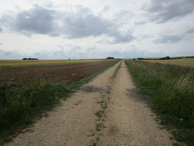
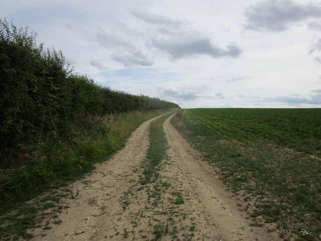
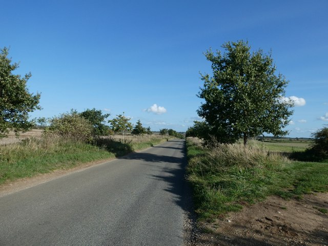
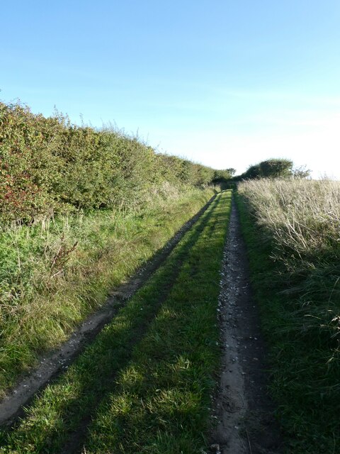
Fring Images

Images are sourced within 2km of 52.882716/0.580074 or Grid Reference TF7334. Thanks to Geograph Open Source API. All images are credited.

Farm track near Fring
Development at Church Farm, Fring Old barns in process of being put to other uses.
Development at Church Farm, Fring
Old barns in process of being put to other uses.
Barley field alongside Osier Carr near Fring
Farm track near Fring
Field of oats near Fring
All Saints, Fring: late September 2023 A delightful church snapped early on an autumn morning
All Saints, Fring: late September 2023
A delightful church snapped early on an autumn morning
Road and path junction near Bircham The Peddars Way meets a road. One way in a vehicle would take you past Bircham Plantation; the other towards the historic windmill <span class="nowrap"><a title="https://www.birchamwindmill.co.uk/" rel="nofollow ugc noopener" href="https://www.birchamwindmill.co.uk/">Link</a><img style="margin-left:2px;" alt="External link" title="External link - shift click to open in new window" src="https://s1.geograph.org.uk/img/external.png" width="10" height="10"/></span>
Road and path junction near Bircham
The Peddars Way meets a road. One way in a vehicle would take you past Bircham Plantation; the other towards the historic windmill LinkExternal link
Looking across a field towards Red Barn Farm Taken from the Peddars Way
Looking across a field towards Red Barn Farm
Taken from the Peddars Way
The Peddars Way meets the Fring Road For a little more about Fring see <span class="nowrap"><a title="https://en.wikipedia.org/wiki/Fring,_Norfolk" rel="nofollow ugc noopener" href="https://en.wikipedia.org/wiki/Fring,_Norfolk">Link</a><img style="margin-left:2px;" alt="External link" title="External link - shift click to open in new window" src="https://s1.geograph.org.uk/img/external.png" width="10" height="10"/></span>
The Peddars Way meets the Fring Road
For a little more about Fring see LinkExternal link
Heading through Hill Plantation Approaching the end of our first day's walking on the Peddars Way
Heading through Hill Plantation
Approaching the end of our first day's walking on the Peddars Way
First one seen today Seen on the Peddars Way right at the end of our first day's walking. I dedicate this photo to my walking friend Skippa who is six months older than me and needs it more!
First one seen today
Seen on the Peddars Way right at the end of our first day's walking. I dedicate this photo to my walking friend Skippa who is six months older than me and needs it more!
The road to Red Barn Farm seen from the Peddars Way The Peddars Way is a long distance footpath in Norfolk. It is 46 miles long and follows the route of a Roman road. It has been suggested by more than one writer that it was not created by the Romans but was an ancient trackway, a branch or extension of the Icknield Way, used and remodelled by the Romans. The name is said to be derived from the Latin pedester – on foot.  It starts at Knettishall Heath in Suffolk (near the Norfolk-Suffolk border, about 4 miles east of Thetford), and it links with the Norfolk Coast Path at Holme-next-the-Sea.
Combined with the Norfolk Coast Path, it forms the Peddars Way & Norfolk Coast Path National Trail, one of 15 National Trails in England and Wales, and the two paths together run for 97 miles.
Wikipedia: <span class="nowrap"><a title="http://en.wikipedia.org/wiki/Peddars_Way" rel="nofollow ugc noopener" href="http://en.wikipedia.org/wiki/Peddars_Way">Link</a><img style="margin-left:2px;" alt="External link" title="External link - shift click to open in new window" src="https://s1.geograph.org.uk/img/external.png" width="10" height="10"/></span>
The road to Red Barn Farm seen from the Peddars Way
The Peddars Way is a long distance footpath in Norfolk. It is 46 miles long and follows the route of a Roman road. It has been suggested by more than one writer that it was not created by the Romans but was an ancient trackway, a branch or extension of the Icknield Way, used and remodelled by the Romans. The name is said to be derived from the Latin pedester – on foot. It starts at Knettishall Heath in Suffolk (near the Norfolk-Suffolk border, about 4 miles east of Thetford), and it links with the Norfolk Coast Path at Holme-next-the-Sea. Combined with the Norfolk Coast Path, it forms the Peddars Way & Norfolk Coast Path National Trail, one of 15 National Trails in England and Wales, and the two paths together run for 97 miles. Wikipedia: LinkExternal link
The road to Great Bircham seen from the Peddars Way The Peddars Way is a long distance footpath in Norfolk. It is 46 miles long and follows the route of a Roman road. It has been suggested by more than one writer that it was not created by the Romans but was an ancient trackway, a branch or extension of the Icknield Way, used and remodelled by the Romans. The name is said to be derived from the Latin pedester – on foot.  It starts at Knettishall Heath in Suffolk (near the Norfolk-Suffolk border, about 4 miles east of Thetford), and it links with the Norfolk Coast Path at Holme-next-the-Sea.
Combined with the Norfolk Coast Path, it forms the Peddars Way & Norfolk Coast Path National Trail, one of 15 National Trails in England and Wales, and the two paths together run for 97 miles.
Wikipedia: <span class="nowrap"><a title="http://en.wikipedia.org/wiki/Peddars_Way" rel="nofollow ugc noopener" href="http://en.wikipedia.org/wiki/Peddars_Way">Link</a><img style="margin-left:2px;" alt="External link" title="External link - shift click to open in new window" src="https://s1.geograph.org.uk/img/external.png" width="10" height="10"/></span>
The road to Great Bircham seen from the Peddars Way
The Peddars Way is a long distance footpath in Norfolk. It is 46 miles long and follows the route of a Roman road. It has been suggested by more than one writer that it was not created by the Romans but was an ancient trackway, a branch or extension of the Icknield Way, used and remodelled by the Romans. The name is said to be derived from the Latin pedester – on foot. It starts at Knettishall Heath in Suffolk (near the Norfolk-Suffolk border, about 4 miles east of Thetford), and it links with the Norfolk Coast Path at Holme-next-the-Sea. Combined with the Norfolk Coast Path, it forms the Peddars Way & Norfolk Coast Path National Trail, one of 15 National Trails in England and Wales, and the two paths together run for 97 miles. Wikipedia: LinkExternal link
Looking towards High Plantation from the Peddars Way The Peddars Way is a long distance footpath in Norfolk. It is 46 miles long and follows the route of a Roman road. It has been suggested by more than one writer that it was not created by the Romans but was an ancient trackway, a branch or extension of the Icknield Way, used and remodelled by the Romans. The name is said to be derived from the Latin pedester – on foot.  It starts at Knettishall Heath in Suffolk (near the Norfolk-Suffolk border, about 4 miles east of Thetford), and it links with the Norfolk Coast Path at Holme-next-the-Sea.
Combined with the Norfolk Coast Path, it forms the Peddars Way & Norfolk Coast Path National Trail, one of 15 National Trails in England and Wales, and the two paths together run for 97 miles.
Wikipedia: <span class="nowrap"><a title="http://en.wikipedia.org/wiki/Peddars_Way" rel="nofollow ugc noopener" href="http://en.wikipedia.org/wiki/Peddars_Way">Link</a><img style="margin-left:2px;" alt="External link" title="External link - shift click to open in new window" src="https://s1.geograph.org.uk/img/external.png" width="10" height="10"/></span>
Looking towards High Plantation from the Peddars Way
The Peddars Way is a long distance footpath in Norfolk. It is 46 miles long and follows the route of a Roman road. It has been suggested by more than one writer that it was not created by the Romans but was an ancient trackway, a branch or extension of the Icknield Way, used and remodelled by the Romans. The name is said to be derived from the Latin pedester – on foot. It starts at Knettishall Heath in Suffolk (near the Norfolk-Suffolk border, about 4 miles east of Thetford), and it links with the Norfolk Coast Path at Holme-next-the-Sea. Combined with the Norfolk Coast Path, it forms the Peddars Way & Norfolk Coast Path National Trail, one of 15 National Trails in England and Wales, and the two paths together run for 97 miles. Wikipedia: LinkExternal link
Looking towards Top Plantation from the Peddars Way The Peddars Way is a long distance footpath in Norfolk. It is 46 miles long and follows the route of a Roman road. It has been suggested by more than one writer that it was not created by the Romans but was an ancient trackway, a branch or extension of the Icknield Way, used and remodelled by the Romans. The name is said to be derived from the Latin pedester – on foot.  It starts at Knettishall Heath in Suffolk (near the Norfolk-Suffolk border, about 4 miles east of Thetford), and it links with the Norfolk Coast Path at Holme-next-the-Sea.
Combined with the Norfolk Coast Path, it forms the Peddars Way & Norfolk Coast Path National Trail, one of 15 National Trails in England and Wales, and the two paths together run for 97 miles.
Wikipedia: <span class="nowrap"><a title="http://en.wikipedia.org/wiki/Peddars_Way" rel="nofollow ugc noopener" href="http://en.wikipedia.org/wiki/Peddars_Way">Link</a><img style="margin-left:2px;" alt="External link" title="External link - shift click to open in new window" src="https://s1.geograph.org.uk/img/external.png" width="10" height="10"/></span>
Looking towards Top Plantation from the Peddars Way
The Peddars Way is a long distance footpath in Norfolk. It is 46 miles long and follows the route of a Roman road. It has been suggested by more than one writer that it was not created by the Romans but was an ancient trackway, a branch or extension of the Icknield Way, used and remodelled by the Romans. The name is said to be derived from the Latin pedester – on foot. It starts at Knettishall Heath in Suffolk (near the Norfolk-Suffolk border, about 4 miles east of Thetford), and it links with the Norfolk Coast Path at Holme-next-the-Sea. Combined with the Norfolk Coast Path, it forms the Peddars Way & Norfolk Coast Path National Trail, one of 15 National Trails in England and Wales, and the two paths together run for 97 miles. Wikipedia: LinkExternal link
Looking towards the White House from the Peddars Way
Looking back to the Fring Road from the Peddars Way The Peddars Way is a long distance footpath in Norfolk. It is 46 miles long and follows the route of a Roman road. It has been suggested by more than one writer that it was not created by the Romans but was an ancient trackway, a branch or extension of the Icknield Way, used and remodelled by the Romans. The name is said to be derived from the Latin pedester – on foot.  It starts at Knettishall Heath in Suffolk (near the Norfolk-Suffolk border, about 4 miles east of Thetford), and it links with the Norfolk Coast Path at Holme-next-the-Sea.
Combined with the Norfolk Coast Path, it forms the Peddars Way & Norfolk Coast Path National Trail, one of 15 National Trails in England and Wales, and the two paths together run for 97 miles.
Wikipedia: <span class="nowrap"><a title="http://en.wikipedia.org/wiki/Peddars_Way" rel="nofollow ugc noopener" href="http://en.wikipedia.org/wiki/Peddars_Way">Link</a><img style="margin-left:2px;" alt="External link" title="External link - shift click to open in new window" src="https://s1.geograph.org.uk/img/external.png" width="10" height="10"/></span>
Looking back to the Fring Road from the Peddars Way
The Peddars Way is a long distance footpath in Norfolk. It is 46 miles long and follows the route of a Roman road. It has been suggested by more than one writer that it was not created by the Romans but was an ancient trackway, a branch or extension of the Icknield Way, used and remodelled by the Romans. The name is said to be derived from the Latin pedester – on foot. It starts at Knettishall Heath in Suffolk (near the Norfolk-Suffolk border, about 4 miles east of Thetford), and it links with the Norfolk Coast Path at Holme-next-the-Sea. Combined with the Norfolk Coast Path, it forms the Peddars Way & Norfolk Coast Path National Trail, one of 15 National Trails in England and Wales, and the two paths together run for 97 miles. Wikipedia: LinkExternal link
The Peddars Way: between the Snettisham and Fring Roads The Peddars Way is a long distance footpath in Norfolk. It is 46 miles long and follows the route of a Roman road. It has been suggested by more than one writer that it was not created by the Romans but was an ancient trackway, a branch or extension of the Icknield Way, used and remodelled by the Romans. The name is said to be derived from the Latin pedester – on foot.  It starts at Knettishall Heath in Suffolk (near the Norfolk-Suffolk border, about 4 miles east of Thetford), and it links with the Norfolk Coast Path at Holme-next-the-Sea.
Combined with the Norfolk Coast Path, it forms the Peddars Way & Norfolk Coast Path National Trail, one of 15 National Trails in England and Wales, and the two paths together run for 97 miles.
Wikipedia: <span class="nowrap"><a title="http://en.wikipedia.org/wiki/Peddars_Way" rel="nofollow ugc noopener" href="http://en.wikipedia.org/wiki/Peddars_Way">Link</a><img style="margin-left:2px;" alt="External link" title="External link - shift click to open in new window" src="https://s1.geograph.org.uk/img/external.png" width="10" height="10"/></span>
The Peddars Way: between the Snettisham and Fring Roads
The Peddars Way is a long distance footpath in Norfolk. It is 46 miles long and follows the route of a Roman road. It has been suggested by more than one writer that it was not created by the Romans but was an ancient trackway, a branch or extension of the Icknield Way, used and remodelled by the Romans. The name is said to be derived from the Latin pedester – on foot. It starts at Knettishall Heath in Suffolk (near the Norfolk-Suffolk border, about 4 miles east of Thetford), and it links with the Norfolk Coast Path at Holme-next-the-Sea. Combined with the Norfolk Coast Path, it forms the Peddars Way & Norfolk Coast Path National Trail, one of 15 National Trails in England and Wales, and the two paths together run for 97 miles. Wikipedia: LinkExternal link
Show me another place!

Fring is located at Grid Ref: TF7334 (Lat: 52.882716, Lng: 0.580074)

Administrative County: Norfolk

District: King's Lynn and West Norfolk

Police Authority: Norfolk

What 3 Words

///mobile.steepest.doctor. Near Snettisham, Norfolk

Related Wikis

Fring, Norfolk

Fring is a civil parish in the English county of Norfolk. It covers an area of 6.93 km2 (2.68 sq mi) and had a population of 94 in 41 households at the...

Sedgeford

Sedgeford is a village and civil parish in the English county of Norfolk, about 5 miles south of the North Sea and 3 miles (4.8 km) east of the Wash. It...

Great Bircham Windmill

Great Bircham Windmill is a Grade II listed tower mill in Great Bircham, Norfolk, England. == History == The earliest record of a windmill in Great Bircham...

Bircham Newton

Bircham Newton is the smallest of the three villages that make up the civil parish of Bircham, in the west of the English county of Norfolk. The village...

Nearby Amenities

Located within 500m of 52.882716,0.580074
Fring
Place: village
Lat/Long: 52.8820508/0.5794691
Church Farm
Place: farm
Lat/Long: 52.884105/0.5784756
Fring Hall
Place: isolated_dwelling
Lat/Long: 52.8866494/0.5826145
Water End
Place: locality
Lat/Long: 52.8810178/0.5806113
Entrance: yes
Lat/Long: 52.883327/0.5779198
Entrance: main
Lat/Long: 52.883229/0.5776799
Give Way
Lat/Long: 52.8823459/0.5796871
Give Way
Lat/Long: 52.8821813/0.579732
Give Way
Lat/Long: 52.882184/0.5794859
Give Way
Lat/Long: 52.88201/0.5784733
Give Way
Lat/Long: 52.8819396/0.5784694
Give Way
Lat/Long: 52.8819968/0.5786962
Give Way
Lat/Long: 52.8812268/0.5775735
Telephone
Booth: K6
Covered: booth
Listed Status: Grade II
Operator: BT
Lat/Long: 52.8826178/0.5799861
Board Type: notice
Information: board
Tourism: information
Lat/Long: 52.8826332/0.5800076
Fring
Inscription: The Place of Frea’s People
Man Made: village_sign
Material: wood
Lat/Long: 52.8826575/0.5801618
The data included in this document is from www.openstreetmap.org. The data is made available under ODbL.

Have you been to Fring?

Leave your review of Fring below (or comments, questions and feedback).