Pond Hall Carr

Wood, Forest in Suffolk Ipswich

England

Pond Hall Carr

Freston Tower A brick built towner probably dating from the 16th Century: <span class="nowrap"><a title="https://en.wikipedia.org/wiki/Freston_Tower" rel="nofollow ugc noopener" href="https://en.wikipedia.org/wiki/Freston_Tower">Link</a><img style="margin-left:2px;" alt="External link" title="External link - shift click to open in new window" src="https://s1.geograph.org.uk/img/external.png" width="10" height="10"/></span>. It now belongs to the Landmark Trust and can be rented as a holdiay home: <span class="nowrap"><a title="https://www.landmarktrust.org.uk/search-and-book/properties/freston-tower-7680/#Overview" rel="nofollow ugc noopener" href="https://www.landmarktrust.org.uk/search-and-book/properties/freston-tower-7680/#Overview">Link</a><img style="margin-left:2px;" alt="External link" title="External link - shift click to open in new window" src="https://s1.geograph.org.uk/img/external.png" width="10" height="10"/></span>
Freston Tower Credit: Chris Holifield

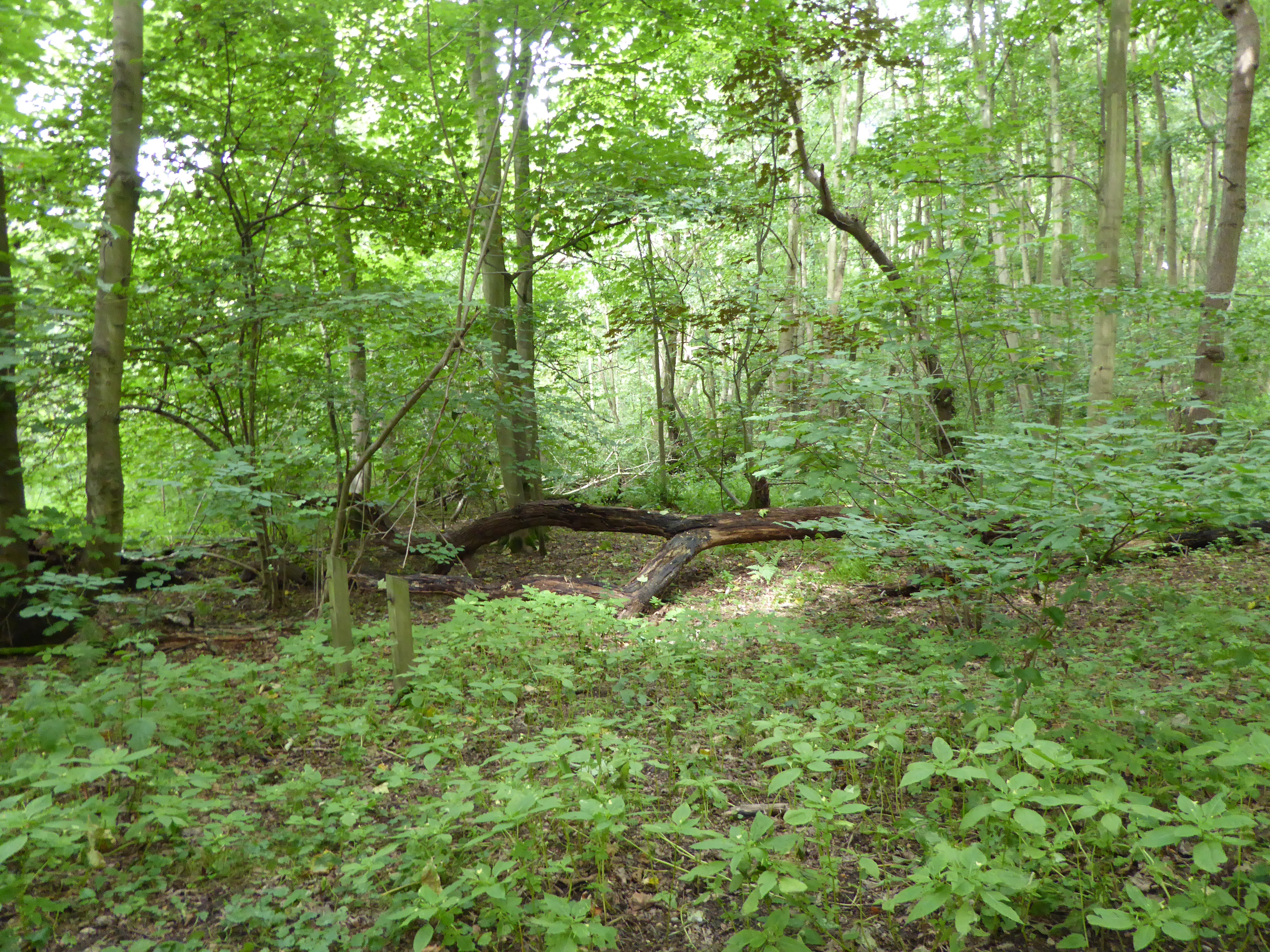
Pond Hall Carr is a picturesque woodland located in Suffolk, England. Situated near the village of Woodbridge, it covers an area of approximately 200 acres and is known for its natural beauty and diverse ecosystem.

The woodland features a variety of tree species, including oak, beech, and birch, which create a dense and enchanting canopy. The forest floor is adorned with a vibrant carpet of bluebells in the spring, adding to the area's charm and attracting visitors from far and wide.

Pond Hall Carr is home to an array of wildlife, making it a popular spot for nature enthusiasts and birdwatchers. Among the creatures that can be spotted here are deer, badgers, foxes, and a variety of bird species, including woodpeckers, owls, and buzzards. The tranquil environment provides a perfect habitat for these animals to thrive.

Visitors can enjoy a peaceful stroll along the numerous trails that wind through the woodland, immersing themselves in the natural serenity that Pond Hall Carr offers. The paths are well-maintained, allowing visitors to explore the forest at their own pace.

The woodland also features a small pond, from which it takes its name. The pond is a haven for wildlife, attracting ducks, frogs, and dragonflies. It provides a perfect spot for picnics or simply to sit and enjoy the tranquil surroundings.

Pond Hall Carr is a hidden gem in Suffolk, offering a tranquil escape from the hustle and bustle of everyday life. Its natural beauty and diverse wildlife make it a must-visit destination for nature lovers and those seeking a peaceful retreat.

If you have any feedback on the listing, please let us know in the comments section below.

Pond Hall Carr Images

Images are sourced within 2km of 52.028171/1.1768535 or Grid Reference TM1841. Thanks to Geograph Open Source API. All images are credited.

Freston Tower A brick built towner probably dating from the 16th Century: <span class="nowrap"><a title="https://en.wikipedia.org/wiki/Freston_Tower" rel="nofollow ugc noopener" href="https://en.wikipedia.org/wiki/Freston_Tower">Link</a><img style="margin-left:2px;" alt="External link" title="External link - shift click to open in new window" src="https://s1.geograph.org.uk/img/external.png" width="10" height="10"/></span>. It now belongs to the Landmark Trust and can be rented as a holdiay home: <span class="nowrap"><a title="https://www.landmarktrust.org.uk/search-and-book/properties/freston-tower-7680/#Overview" rel="nofollow ugc noopener" href="https://www.landmarktrust.org.uk/search-and-book/properties/freston-tower-7680/#Overview">Link</a><img style="margin-left:2px;" alt="External link" title="External link - shift click to open in new window" src="https://s1.geograph.org.uk/img/external.png" width="10" height="10"/></span>
Freston Tower
A brick built towner probably dating from the 16th Century: LinkExternal link. It now belongs to the Landmark Trust and can be rented as a holdiay home: LinkExternal link
Freston Tower Freston Tower, owned by The Landmark Trust. We stayed there in October 2005!
Freston Tower
Freston Tower, owned by The Landmark Trust. We stayed there in October 2005!
'The Boot' inn at Freston, Suffolk This inn stands on Freston Hill on the B.1456
'The Boot' inn at Freston, Suffolk
This inn stands on Freston Hill on the B.1456
River Orwell saltmarsh An area of saltmarsh at Freston, on the west bank of the River Orwell. The areas of saltmarsh - or 'saltings' - in the river have eroded considerably in recent decades. This may be partly due to the effect of wash from larger vessels using the port of Ipswich.
River Orwell saltmarsh
An area of saltmarsh at Freston, on the west bank of the River Orwell. The areas of saltmarsh - or 'saltings' - in the river have eroded considerably in recent decades. This may be partly due to the effect of wash from larger vessels using the port of Ipswich.
River Orwell foreshore On the Freston foreshore the saltings have eroded, leaving only remnants of slightly harder soil. These apparent 'rocks' are in fact lumps of hardened mud, which will probably disappear in time.
River Orwell foreshore
On the Freston foreshore the saltings have eroded, leaving only remnants of slightly harder soil. These apparent 'rocks' are in fact lumps of hardened mud, which will probably disappear in time.
River Orwell tributary This unnamed stream enters the River Orwell from Freston Park.
River Orwell tributary
This unnamed stream enters the River Orwell from Freston Park.
Freston Park The parkland extends to the river bank, by the line of gorse bushes. The River Orwell and the Orwell Bridge can be seen in the distance.
Freston Park
The parkland extends to the river bank, by the line of gorse bushes. The River Orwell and the Orwell Bridge can be seen in the distance.
Freston Park and Tower The parkland surrounds the tower and neighbouring farmhouse. The folly is owned by the Landmark Trust, and is rented out as one of their more unusual properties.
Freston Park and Tower
The parkland surrounds the tower and neighbouring farmhouse. The folly is owned by the Landmark Trust, and is rented out as one of their more unusual properties.
Riverbank tree This dead tree is on the bank of the River Orwell, below Freston Tower, which can be seen behind the gorse bushes.
Riverbank tree
This dead tree is on the bank of the River Orwell, below Freston Tower, which can be seen behind the gorse bushes.
River Orwell transit beacon The beacon used to be much larger, and higher, and acted as a transit against Freston Tower on the hillside behind. It was used before the Orwell was dredged and straightened and enabled sailing vessels to steer the right course on the then tortuous journey upstream to Ipswich.
River Orwell transit beacon
The beacon used to be much larger, and higher, and acted as a transit against Freston Tower on the hillside behind. It was used before the Orwell was dredged and straightened and enabled sailing vessels to steer the right course on the then tortuous journey upstream to Ipswich.
Freston Park Looking over to the River Orwell from below Freston Tower.
Freston Park
Looking over to the River Orwell from below Freston Tower.
Eroding saltmarsh Lumps of solidified mud remain, remnants of the former extensive saltmarsh on the bank of the River Orwell. On top of the lumps, edible sea purslane (Halimione portulacoides) is growing. In the background is the Orwell Bridge.
Eroding saltmarsh
Lumps of solidified mud remain, remnants of the former extensive saltmarsh on the bank of the River Orwell. On top of the lumps, edible sea purslane (Halimione portulacoides) is growing. In the background is the Orwell Bridge.
Edge of the saltmarsh It can be seen how easily this saltmarsh on the west bank of the River Orwell is being eroded by high tides and waves. The edge is very fragile, despite being covered in places with sea purslane.
Edge of the saltmarsh
It can be seen how easily this saltmarsh on the west bank of the River Orwell is being eroded by high tides and waves. The edge is very fragile, despite being covered in places with sea purslane.
Freston Tower This Landmark Trust-owned tower was built in the mid 16th century and is reputed to be England's oldest folly. But is it a folly? Rumour has it that it was built by William Latymer for Lord de Freston as a remote place of study for the Lord's daughter Ellen.  Apparently she had the use of each of the six floors of the tower for a specific purpose, hence the much quoted instruction:

    The Lower Room to charity from 7 to 8 o'clock
    The Second to working tapestry from 9 to 10
    The Third to music from 10 to noon
    The Fourth to painting from 12 to 1
    The Fifth to literature from 1 to 2
    The Sixth to astronomy at even

Other legends say it was a lookout, or signalling tower, dominating as it does the River Orwell.  Or it may have simply been a folly...

Following the Landmark Trust's acquisition of the tower in 1999, it was renovated and opened as a holiday home in May 2004.
Freston Tower
This Landmark Trust-owned tower was built in the mid 16th century and is reputed to be England's oldest folly. But is it a folly? Rumour has it that it was built by William Latymer for Lord de Freston as a remote place of study for the Lord's daughter Ellen. Apparently she had the use of each of the six floors of the tower for a specific purpose, hence the much quoted instruction: The Lower Room to charity from 7 to 8 o'clock The Second to working tapestry from 9 to 10 The Third to music from 10 to noon The Fourth to painting from 12 to 1 The Fifth to literature from 1 to 2 The Sixth to astronomy at even Other legends say it was a lookout, or signalling tower, dominating as it does the River Orwell. Or it may have simply been a folly... Following the Landmark Trust's acquisition of the tower in 1999, it was renovated and opened as a holiday home in May 2004.
Freston Park Parkland viewed from the bank of the River Orwell.
Freston Park
Parkland viewed from the bank of the River Orwell.
Cargo ship in the River Orwell The MV Velox is departing the port of Ipswich, heading downstream towards Harwich Harbour.
Cargo ship in the River Orwell
The MV Velox is departing the port of Ipswich, heading downstream towards Harwich Harbour.
Freston Tower The Landmark Trust, which owns this tower, had an Open Day today, which meant that access to the top was available.
Freston Tower
The Landmark Trust, which owns this tower, had an Open Day today, which meant that access to the top was available.
River Orwell from Freston Tower Looking across parkland below the tower to the river and, in the distance, the Orwell Bridge.
River Orwell from Freston Tower
Looking across parkland below the tower to the river and, in the distance, the Orwell Bridge.
Show me another place!

Pond Hall Carr is located at Grid Ref: TM1841 (Lat: 52.028171, Lng: 1.1768535)

Administrative County: Suffolk

District: Ipswich

Police Authority: Suffolk

What 3 Words

///recorder.loom.newsreel. Near Ipswich, Suffolk

Related Wikis

Pipers Vale

Pipers Vale is a 19.7 hectare Local Nature Reserve on the southern outskirts of Ipswich in Suffolk. It is owned and managed by Ipswich Borough Council...

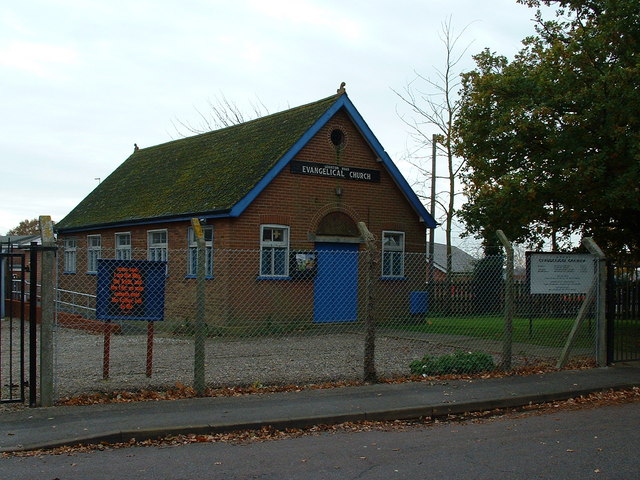
Leighton Road Evangelical Church, Ipswich

Leighton Road Evangelical Church is a nonconformist independent evangelical church located on the Gainsborough estate, Ipswich in the English county of...

Gainsborough, Ipswich

Gainsborough is an area of Ipswich, in the Ipswich district, in the county of Suffolk, England. It was named after the artist Thomas Gainsborough of Sudbury...
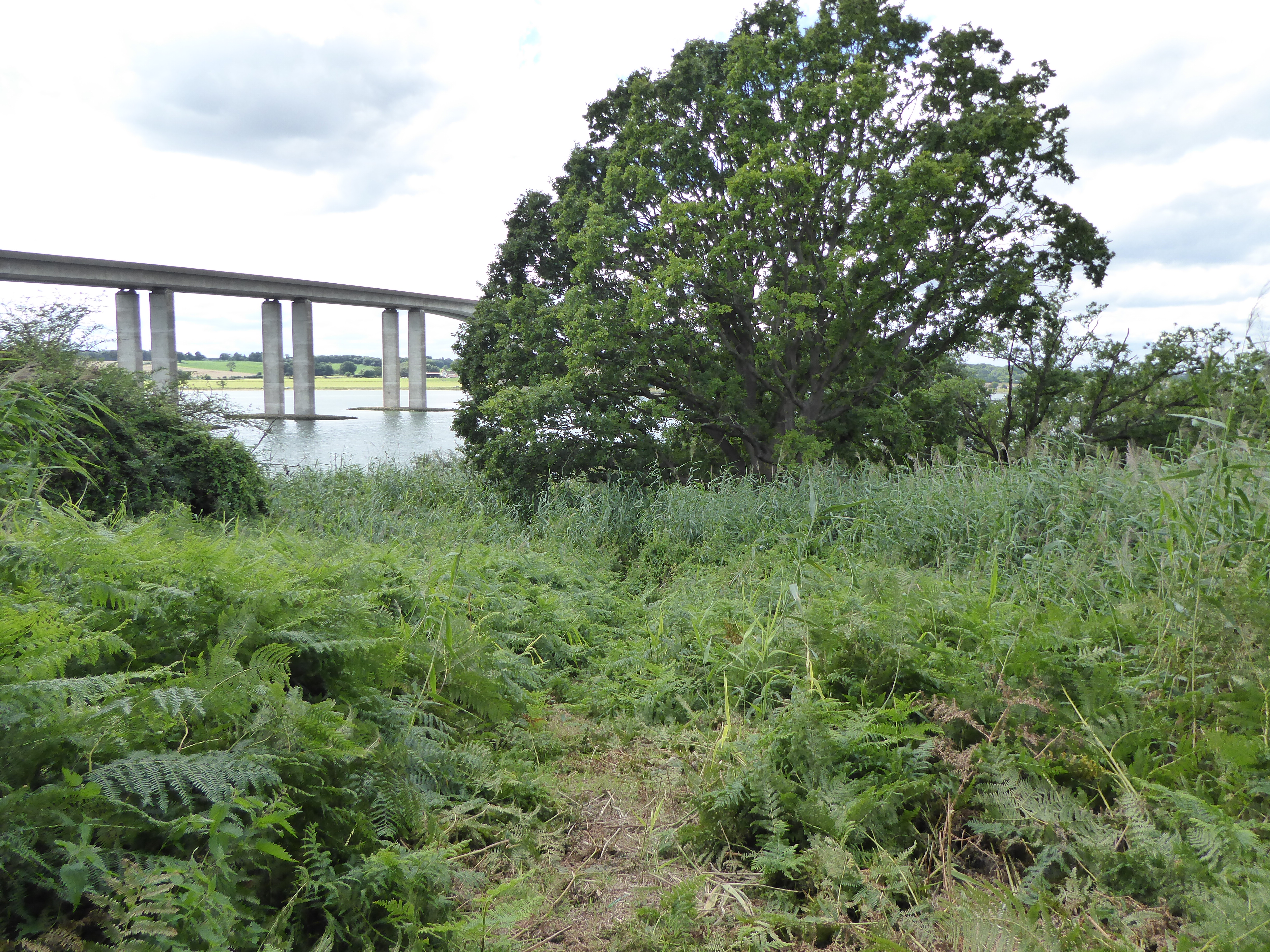
Orwell Bridge

The Orwell Bridge is a concrete box girder bridge just south of Ipswich in Suffolk, England. Opened to road traffic in 1982, the bridge carries the A14...

Ipswich Gymnastics Centre

Ipswich Gymnastics Centre in Ipswich is one of only three fully London Organising Committee for the Olympic Games (LOCOG) accredited gymnastics facilities...

Greenwich, Ipswich

Greenwich is a suburban area of Ipswich, in the Ipswich district, in the county of Suffolk, England. For many years it was a hamlet included in the parish...

Bridge Wood

Bridge Wood is a 31 hectare Local Nature Reserve on the southern outskirts of Ipswich in Suffolk, England. It is owned and managed by Ipswich Borough Council...

South East Area, Ipswich

The South East Area, Ipswich is one of five administrative areas in Ipswich, through which Ipswich Borough Council divides its spending and enables feedback...

Nearby Amenities

Located within 500m of 52.028171,1.1768535
Created By: almien_coastlines
Source: PGS
Lat/Long: 52.0294428/1.1702959
Created By: almien_coastlines
Source: PGS
Lat/Long: 52.029039/1.1706233
Created By: almien_coastlines
Source: PGS
Lat/Long: 52.0281388/1.1711229
Created By: almien_coastlines
Source: PGS
Lat/Long: 52.027275/1.171607
Source: PGS
Lat/Long: 52.0271038/1.1719009
Source: PGS
Lat/Long: 52.0265229/1.1722014
Source: PGS
Lat/Long: 52.026107/1.1725339
Source: PGS
Lat/Long: 52.0252224/1.1731562
Source: PGS
Lat/Long: 52.0248329/1.1735639
Source: PGS
Lat/Long: 52.0240001/1.1743209
Barrier: kissing_gate
Lat/Long: 52.0272365/1.1754239
Turning Circle
Lat/Long: 52.0302307/1.1802504
Barrier: kissing_gate
Lat/Long: 52.0266238/1.1726134
Barrier: stile
Foot: yes
Lat/Long: 52.0242085/1.1771493
Lely Road
Local Ref: opp
Naptan AtcoCode: 390010782
Naptan Bearing: SW
Naptan BusStopType: CUS
Naptan CommonName: Lely Road
Naptan Landmark: Lely Road
Naptan NaptanCode: sufjmwdt
Naptan PlusbusZoneRef: IPSWICH
Naptan Street: Fletcher Road
Naptan Verified: no
Source: naptan_import
Lat/Long: 52.0311372/1.1769326
Lely Road
Local Ref: adj
Naptan AtcoCode: 390010783
Naptan Bearing: NE
Naptan BusStopType: CUS
Naptan CommonName: Lely Road
Naptan Landmark: Lely Road
Naptan NaptanCode: sufjmwdw
Naptan PlusbusZoneRef: IPSWICH
Naptan Street: Fletcher Road
Naptan Verified: no
Source: naptan_import
Lat/Long: 52.0310349/1.1767212
Bench
Lat/Long: 52.0254776/1.1826333
Natural: spring
Lat/Long: 52.0274126/1.1775241
Barrier: stile
Stile: squeezer
Lat/Long: 52.0271396/1.1736435
Bench
Lat/Long: 52.0292425/1.1732865
Bench
Lat/Long: 52.0279117/1.1733294
Barrier: stile
Lat/Long: 52.027884/1.1743704
Natural: spring
Lat/Long: 52.0266804/1.1835259
Material: wood
Power: pole
Lat/Long: 52.0246681/1.1807673
Phone
Emergency: phone
Lat/Long: 52.0270133/1.1751104
Speed Camera
Lat/Long: 52.0268371/1.17437
Speed Camera
Maxspeed: 60 mph
Maxspeed Variable: yes
Lat/Long: 52.0259688/1.1796794
Speed Camera
Maxspeed: 60 mph
Maxspeed Variable: yes
Lat/Long: 52.0260576/1.180455
Material: wood
Max Age: 11
Min Age: 5
Playground: multi_play
Lat/Long: 52.0292742/1.1807649
Phone
Emergency: phone
Operator: Samaritans
Lat/Long: 52.0270925/1.1742396
Phone
Emergency: phone
Operator: Samaritans
Lat/Long: 52.0268248/1.1742596
Waste Basket
Waste: dog_excrement
Lat/Long: 52.0271275/1.1735938
Give Way
Direction: forward
Lat/Long: 52.0318447/1.178859
Give Way
Direction: backward
Lat/Long: 52.0312873/1.1795892
Give Way
Direction: forward
Lat/Long: 52.0312164/1.1796827
The data included in this document is from www.openstreetmap.org. The data is made available under ODbL.

Have you been to Pond Hall Carr?

Leave your review of Pond Hall Carr below (or comments, questions and feedback).