Nut Grove

Wood, Forest in Norfolk South Norfolk

England

Nut Grove

Wymondham Road, Wreningham
Wymondham Road, Wreningham Credit: Evelyn Simak

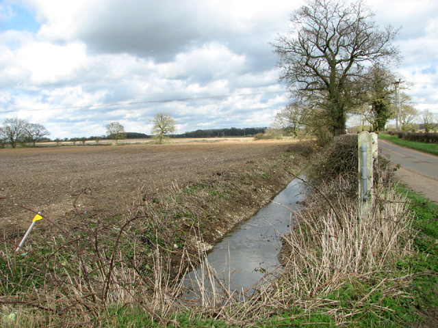
Nut Grove is a picturesque woodland area located in Norfolk, England. Situated in the rural countryside, this wood is renowned for its natural beauty and tranquility, making it a popular destination for nature enthusiasts and hikers alike.

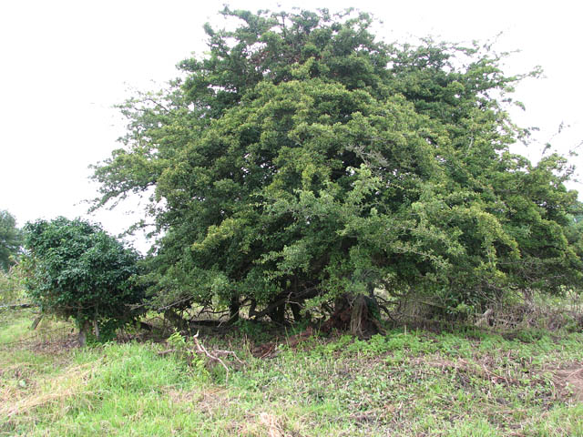
Covering an area of approximately 100 acres, Nut Grove is predominantly composed of a variety of broadleaf trees, including oak, beech, and birch. The dense foliage provides a rich habitat for a diverse range of wildlife, including squirrels, rabbits, and numerous bird species.

The woodland is crisscrossed by a network of well-maintained footpaths, allowing visitors to explore and appreciate the natural surroundings. These paths wind through the ancient trees, offering stunning views of the seasonal changes in foliage and providing a peaceful atmosphere for relaxation and contemplation.

Nut Grove also boasts a small pond, which is home to various aquatic plants and insects. Additionally, a brook meanders through the wood, adding to its scenic charm and providing a refreshing spot for visitors to cool off on hot summer days.

The wood is managed by the local council, which ensures its preservation and upkeep. It is open to the public year-round, free of charge, and is a popular spot for families, dog walkers, and photography enthusiasts.

Overall, Nut Grove is a hidden gem in Norfolk, offering visitors a chance to escape the hustle and bustle of city life and immerse themselves in the beauty of nature.

If you have any feedback on the listing, please let us know in the comments section below.

Nut Grove Images

Images are sourced within 2km of 52.562674/1.1665311 or Grid Reference TG1400. Thanks to Geograph Open Source API. All images are credited.

Wymondham Road, Wreningham
Entrance to High House Farm, Wreningham Apparently no longer a working farm.
Entrance to High House Farm, Wreningham
Apparently no longer a working farm.
High House Farm, Wreningham Apparently no longer a working farm.
High House Farm, Wreningham
Apparently no longer a working farm.
Disused railway bridge, Wreningham Disused bridge over dismantled railway trackbed. The track formed part of the cut-off railway line which ran between Forncett and Wymondham. The originally single-track line was used for main line diversion trains during the floods of 1912 and it was doubled for military purposes during WWI. Station buildings remain at nearby Ashwellthorpe > <a title="https://www.geograph.org.uk/photo/1412303" href="https://www.geograph.org.uk/photo/1412303">Link</a>. 

This section of the dismantled line is accessible via steps or from the bridge over Wymondham Road > <a title="https://www.geograph.org.uk/photo/1612486" href="https://www.geograph.org.uk/photo/1612486">Link</a> up until near High House Farm > <a title="https://www.geograph.org.uk/photo/2397875" href="https://www.geograph.org.uk/photo/2397875">Link</a> a short distance further to the north-west from here.
Disused railway bridge, Wreningham
Disused bridge over dismantled railway trackbed. The track formed part of the cut-off railway line which ran between Forncett and Wymondham. The originally single-track line was used for main line diversion trains during the floods of 1912 and it was doubled for military purposes during WWI. Station buildings remain at nearby Ashwellthorpe > Link. This section of the dismantled line is accessible via steps or from the bridge over Wymondham Road > Link up until near High House Farm > Link a short distance further to the north-west from here.
Nettles growing on disused railway bridge, Wreningham Disused bridge over dismantled railway trackbed. The track formed part of the cut-off railway line which ran between Forncett and Wymondham. The originally single-track line was used for main line diversion trains during the floods of 1912 and it was doubled for military purposes during WWI. Station buildings remain at nearby Ashwellthorpe > <a title="https://www.geograph.org.uk/photo/1412303" href="https://www.geograph.org.uk/photo/1412303">Link</a>. 

This section of the dismantled line is accessible via steps or from the bridge over Wymondham Road > <a title="https://www.geograph.org.uk/photo/1612486" href="https://www.geograph.org.uk/photo/1612486">Link</a> up until near High House Farm > <a title="https://www.geograph.org.uk/photo/2397875" href="https://www.geograph.org.uk/photo/2397875">Link</a> a short distance further to the north-west from here.
Nettles growing on disused railway bridge, Wreningham
Disused bridge over dismantled railway trackbed. The track formed part of the cut-off railway line which ran between Forncett and Wymondham. The originally single-track line was used for main line diversion trains during the floods of 1912 and it was doubled for military purposes during WWI. Station buildings remain at nearby Ashwellthorpe > Link. This section of the dismantled line is accessible via steps or from the bridge over Wymondham Road > Link up until near High House Farm > Link a short distance further to the north-west from here.
Disused railway bridge, Wreningham Disused bridge over dismantled railway trackbed. The track formed part of the cut-off railway line which ran between Forncett and Wymondham. The originally single-track line was used for main line diversion trains during the floods of 1912 and it was doubled for military purposes during WWI. Station buildings remain at nearby Ashwellthorpe > <a title="https://www.geograph.org.uk/photo/1412303" href="https://www.geograph.org.uk/photo/1412303">Link</a>. 

This section of the dismantled line is accessible via steps or from the bridge over Wymondham Road > <a title="https://www.geograph.org.uk/photo/1612486" href="https://www.geograph.org.uk/photo/1612486">Link</a> up until near High House Farm > <a title="https://www.geograph.org.uk/photo/2397875" href="https://www.geograph.org.uk/photo/2397875">Link</a> a short distance further to the north-west from here.
Disused railway bridge, Wreningham
Disused bridge over dismantled railway trackbed. The track formed part of the cut-off railway line which ran between Forncett and Wymondham. The originally single-track line was used for main line diversion trains during the floods of 1912 and it was doubled for military purposes during WWI. Station buildings remain at nearby Ashwellthorpe > Link. This section of the dismantled line is accessible via steps or from the bridge over Wymondham Road > Link up until near High House Farm > Link a short distance further to the north-west from here.
Entrance to Long's Wood Long's Wood was founded in 1994 by Dennis Long, whose family have farmed here for over a century.  He wishes to secure this resource as an amenity for the future, to share with the community and to provide a varied wildlife habitat.  The planting of the 70 acre community woodland situated to the south-west of Wymondham began in 1994 when local schoolchildren planted an area marked as Debro's on the information board's display > <a title="https://www.geograph.org.uk/photo/2397908" href="https://www.geograph.org.uk/photo/2397908">Link</a>.  The land was then in arable cultivation, and the sections of the woodland derive their names from existing field names, family history and local characters.
Entrance to Long's Wood
Long's Wood was founded in 1994 by Dennis Long, whose family have farmed here for over a century. He wishes to secure this resource as an amenity for the future, to share with the community and to provide a varied wildlife habitat. The planting of the 70 acre community woodland situated to the south-west of Wymondham began in 1994 when local schoolchildren planted an area marked as Debro's on the information board's display > Link. The land was then in arable cultivation, and the sections of the woodland derive their names from existing field names, family history and local characters.
Entrance to Long's Wood - information board (map) For a wider view of this location see > <a title="https://www.geograph.org.uk/photo/2397902" href="https://www.geograph.org.uk/photo/2397902">Link</a>.
Entrance to Long's Wood - information board (map)
For a wider view of this location see > Link.
Entrance to Corporation Farm
Ditch beside Wymondham Road
Fields west of Bridge Road
Fields by Hall Farm
Fields by Hall Farm
View along Bridge Road The bridge can be seen in mid-distance.
View along Bridge Road
The bridge can be seen in mid-distance.
Ditch beside Bridge Road
Culvert under Bridge Road
Track into fields west of Bridge Road
Fields by Common Farm
Show me another place!

Nut Grove is located at Grid Ref: TG1400 (Lat: 52.562674, Lng: 1.1665311)

Administrative County: Norfolk

District: South Norfolk

Police Authority: Norfolk

What 3 Words

///headers.workouts.weekend. Near Hethel, Norfolk

Nearby Locations

Nut Grove

Related Wikis

RAF Hethel

Royal Air Force Hethel or more simply RAF Hethel is a former Royal Air Force station (ICAO: EGSK) which was used by both the United States Army Air Forces...

Murders at Stanfield Hall

The Murders at Stanfield Hall were a notorious Victorian era double murder on 28 November 1848 that was commemorated in print, pottery, wax, as well as...

Forehoe and Henstead Rural District

Forehoe and Henstead Rural Districts were adjacent rural districts in Norfolk, England from 1894 to 1935.They were formed under the Local Government Act...

Spinks Lane railway station

Spink's Lane was a railway station on Spink's Lane on the eastern outskirts of Wymondham, Norfolk. It was opened very briefly in 1845 to trains on the...

Hethel Old Thorn

Hethel Old Thorn is a 0.025-hectare (0.062-acre) nature reserve south-west of Norwich in Norfolk. It is managed by the Norfolk Wildlife Trust.This is...

Ketteringham

Ketteringham is a village and civil parish in the English county of Norfolk. The parish covers an area of 6.50 km2 (2.51 sq mi) and had a population of...

Hethel

Hethel is a small village in Norfolk, England, approximately five miles (8.0 km) southeast of the market town of Wymondham, and approximately ten miles...

Wreningham

Wreningham is a village and civil parish in the English county of Norfolk. It is situated some 3 miles (4.8 km) south east of Wymondham and 9 miles (14...

Have you been to Nut Grove?

Leave your review of Nut Grove below (or comments, questions and feedback).