Carleton Plantations
Wood, Forest in Norfolk South Norfolk
England
Carleton Plantations

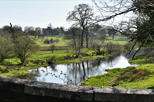
Carleton Plantations, Norfolk, also known as Wood or Forest Carleton, is a historic woodland located in the county of Norfolk, England. Covering a vast area of approximately 2,000 acres, this ancient woodland is renowned for its natural beauty and rich biodiversity.
The plantation is predominantly composed of native tree species such as oak, beech, and birch, which have thrived in the area for centuries. These trees create a dense canopy that provides shelter to numerous wildlife species, including deer, foxes, and various bird species.
Carleton Plantations is known for its well-preserved ancient woodland features, including ancient trees, moss-covered logs, and a diverse range of fungi. It also boasts a diverse understory, with a carpet of wildflowers and ferns adding to the enchanting ambiance of the forest.
The woodland has a long history, with evidence of human activity dating back to the Iron Age. In medieval times, Carleton Plantations were managed intensively for timber, providing a valuable resource for the local community. Today, the woodland is managed sustainably, with selective logging and conservation efforts to maintain its ecological balance.
The plantation is a popular destination for nature enthusiasts, hikers, and photographers, offering an escape from the hustle and bustle of urban life. It is crisscrossed by a network of well-maintained footpaths, providing visitors with opportunities to explore its scenic beauty and observe the diverse flora and fauna.
Carleton Plantations, Norfolk, stands as a testament to the enduring natural beauty and ecological importance of ancient woodlands in the United Kingdom, offering a tranquil retreat for all who visit.
If you have any feedback on the listing, please let us know in the comments section below.
Carleton Plantations Images
Images are sourced within 2km of 52.608138/1.0960812 or Grid Reference TG0905. Thanks to Geograph Open Source API. All images are credited.


Carleton Plantations is located at Grid Ref: TG0905 (Lat: 52.608138, Lng: 1.0960812)
Administrative County: Norfolk
District: South Norfolk
Police Authority: Norfolk
What 3 Words
///tape.messaging.weaved. Near Hethersett, Norfolk
Nearby Locations
Related Wikis

Carleton Forehoe
Carleton Forehoe is a village and former civil parish 9 miles (14 km) west of Norwich, now in the parish of Kimberley, in the South Norfolk district, in...

Wramplingham
Wramplingham is a village and civil parish in the English county of Norfolk. It is situated on the River Tiffey some 4 miles (6.4 km) north of Wymondham...

Barnham Broom
Barnham Broom is a village and civil parish in the English county of Norfolk. The village is situated on the River Yare, 9 miles (15 km) West of Norwich...

Barford, Norfolk
Barford is a village and civil parish in the English county of Norfolk, situated some 4 miles (6 km) north of Wymondham and 8 miles (13 km) west of Norwich...

Wicklewood Roman Temple
Wicklewood Roman Temple is the site of a Romano-Celtic temple near Wicklewood and about 1.5 miles (2.4 km) north-west of Wymondham, in Norfolk, England...
Kimberley, Norfolk
Kimberley is a village and civil parish in the South Norfolk district, in the county of Norfolk, England, situated about 3 miles (4.8 km) north-west of...
Brandon Parva
Brandon Parva is a village and former civil parish, now in the parish of Brandon Parva, Coston, Runhall and Welborne, in the South Norfolk district, in...

River Tiffey
The River Tiffey is a small river in Norfolk, England and a tributary of the River Yare. It rises near Hethel and passes through Wymondham before flowing...
Nearby Amenities
Located within 500m of 52.608138,1.0960812Have you been to Carleton Plantations?
Leave your review of Carleton Plantations below (or comments, questions and feedback).