South Bishops Den

Wood, Forest in Kent Swale

England

South Bishops Den

Horselees Road, by Meadow Wood Looking towards Boughton-under-Blean
Horselees Road, by Meadow Wood Credit: pam fray

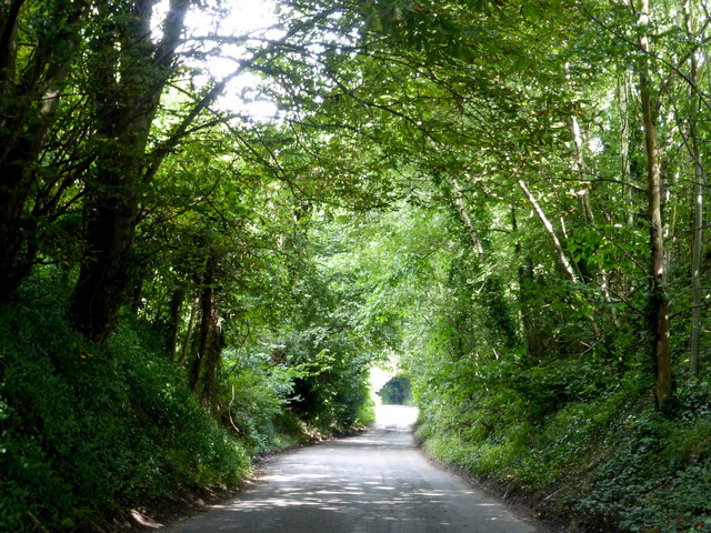
South Bishops Den is a picturesque woodland located in Kent, England. Situated in the heart of the county, this area is known for its dense forest and abundance of wildlife. Covering an expansive area of approximately 200 acres, South Bishops Den is a popular destination for nature enthusiasts and outdoor enthusiasts alike.

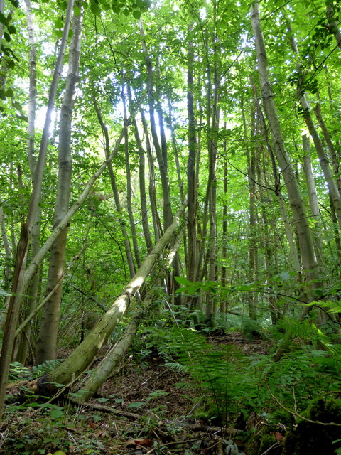
The woodland is characterized by its diverse ecosystem, which includes a variety of tree species such as oak, beech, and birch. These towering trees create a dense canopy that provides shelter for a wide range of fauna. Visitors to the area can expect to encounter various bird species, including woodpeckers, owls, and songbirds, making it a haven for birdwatchers.

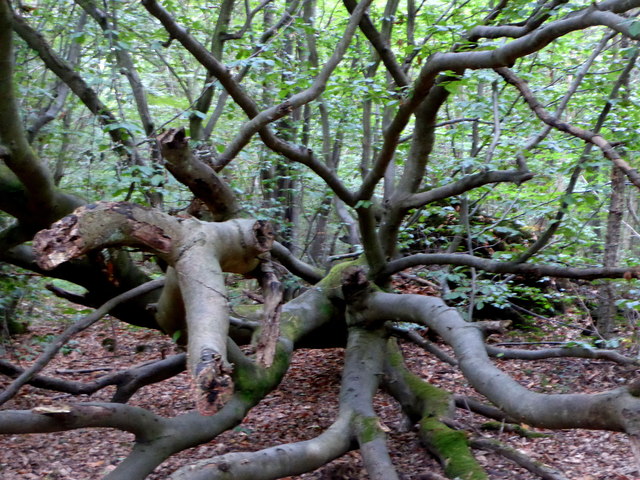
The forest floor is adorned with an array of wildflowers and ferns, creating a colorful and vibrant display during the summer months. Additionally, the woodland is home to several species of mammals, including deer, foxes, and squirrels, offering a chance for wildlife enthusiasts to observe these creatures in their natural habitat.

South Bishops Den is crisscrossed with walking trails, allowing visitors to explore the woodland at their own pace. These paths lead through the enchanting forest, offering glimpses of tranquil ponds and meandering streams along the way. The area is well-maintained, with picnic areas and benches scattered throughout, providing a perfect spot for visitors to relax and enjoy the serene surroundings.

Overall, South Bishops Den in Kent is a captivating woodland that offers a haven of tranquility and natural beauty. Whether it's a leisurely stroll, birdwatching, or simply enjoying a peaceful picnic, this woodland serves as an idyllic escape from the hustle and bustle of everyday life.

If you have any feedback on the listing, please let us know in the comments section below.

South Bishops Den Images

Images are sourced within 2km of 51.281705/0.98463308 or Grid Reference TR0857. Thanks to Geograph Open Source API. All images are credited.

Horselees Road, by Meadow Wood Looking towards Boughton-under-Blean
Horselees Road, by Meadow Wood
Looking towards Boughton-under-Blean
Meadow Wood, near Boughton-under-Blean Viewed from Horselees Road.
Meadow Wood, near Boughton-under-Blean
Viewed from Horselees Road.
Ordnance Survey Flush Bracket S6173 This can be found on the roadside wall of the former primary school in Dunkirk.
For more detail see : <span class="nowrap"><a title="http://www.bench-marks.org.uk/bm19720" rel="nofollow ugc noopener" href="http://www.bench-marks.org.uk/bm19720">Link</a><img style="margin-left:2px;" alt="External link" title="External link - shift click to open in new window" src="https://s1.geograph.org.uk/img/external.png" width="10" height="10"/></span>
Ordnance Survey Flush Bracket S6173
This can be found on the roadside wall of the former primary school in Dunkirk. For more detail see : LinkExternal link
Track in Bossenden Wood, Dunkirk It was in this wood in 1835 that what is thought to be the last battle on English soil took place. During a period of unrest a group of rural labourers led by John Tom, who called himself Sir William Courtenay, entered into battle with soldiers after Courtenay had murdered a local constable. A total of 11 men were killed including 8 of Courtenay's followers.
Track in Bossenden Wood, Dunkirk
It was in this wood in 1835 that what is thought to be the last battle on English soil took place. During a period of unrest a group of rural labourers led by John Tom, who called himself Sir William Courtenay, entered into battle with soldiers after Courtenay had murdered a local constable. A total of 11 men were killed including 8 of Courtenay's followers.
Cleared woodland in Bossenden Wood, Dunkirk
Dead tree by a path in Bossenden Wood, Dunkirk It was in this wood in 1835 that what is thought to be the last battle on English soil took place. During a period of unrest a group of rural labourers led by John Tom, who called himself Sir William Courtenay, entered into battle with soldiers after Courtenay had murdered a local constable. A total of 11 men were killed including 8 of Courtenay's followers.
Dead tree by a path in Bossenden Wood, Dunkirk
It was in this wood in 1835 that what is thought to be the last battle on English soil took place. During a period of unrest a group of rural labourers led by John Tom, who called himself Sir William Courtenay, entered into battle with soldiers after Courtenay had murdered a local constable. A total of 11 men were killed including 8 of Courtenay's followers.
Fungi on a tree stump, Bossenden Wood, Dunkirk It was in this wood in 1835 that what is thought to be the last battle on English soil took place. During a period of unrest a group of rural labourers led by John Tom, who called himself Sir William Courtenay, entered into battle with soldiers after Courtenay had murdered a local constable. A total of 11 men were killed including 8 of Courtenay's followers.
Fungi on a tree stump, Bossenden Wood, Dunkirk
It was in this wood in 1835 that what is thought to be the last battle on English soil took place. During a period of unrest a group of rural labourers led by John Tom, who called himself Sir William Courtenay, entered into battle with soldiers after Courtenay had murdered a local constable. A total of 11 men were killed including 8 of Courtenay's followers.
A2 The A2 runs 72 miles from Borough <a href="https://www.geograph.org.uk/photo/5739288">TQ3279 : Great Dover St</a> in London to Dover, through Kent, formerly known as the Dover Road or Great Dover Road. It follows roughly the course of the Roman Watling Street and historically it has always been an important road because it connects London with Canterbury and the port of Dover. In the 18th and 19th century it was turnpiked and given its present designation in the 1920s.
A2
The A2 runs 72 miles from Borough TQ3279 : Great Dover St in London to Dover, through Kent, formerly known as the Dover Road or Great Dover Road. It follows roughly the course of the Roman Watling Street and historically it has always been an important road because it connects London with Canterbury and the port of Dover. In the 18th and 19th century it was turnpiked and given its present designation in the 1920s.
Dunkirk turning, A2 The A2 runs 72 miles from Borough <a href="https://www.geograph.org.uk/photo/5739288">TQ3279 : Great Dover St</a> in London to Dover, through Kent, formerly known as the Dover Road or Great Dover Road. It follows roughly the course of the Roman Watling Street and historically it has always been an important road because it connects London with Canterbury and the port of Dover. In the 18th and 19th century it was turnpiked and given its present designation in the 1920s.
Dunkirk turning, A2
The A2 runs 72 miles from Borough TQ3279 : Great Dover St in London to Dover, through Kent, formerly known as the Dover Road or Great Dover Road. It follows roughly the course of the Roman Watling Street and historically it has always been an important road because it connects London with Canterbury and the port of Dover. In the 18th and 19th century it was turnpiked and given its present designation in the 1920s.
Bridge over the A2 The A2 runs 72 miles from Borough <a href="https://www.geograph.org.uk/photo/5739288">TQ3279 : Great Dover St</a> in London to Dover, through Kent, formerly known as the Dover Road or Great Dover Road. It follows roughly the course of the Roman Watling Street and historically it has always been an important road because it connects London with Canterbury and the port of Dover. In the 18th and 19th century it was turnpiked and given its present designation in the 1920s.
Bridge over the A2
The A2 runs 72 miles from Borough TQ3279 : Great Dover St in London to Dover, through Kent, formerly known as the Dover Road or Great Dover Road. It follows roughly the course of the Roman Watling Street and historically it has always been an important road because it connects London with Canterbury and the port of Dover. In the 18th and 19th century it was turnpiked and given its present designation in the 1920s.
The A2 The A2 runs 72 miles from Borough <a href="https://www.geograph.org.uk/photo/5739288">TQ3279 : Great Dover St</a> in London to Dover, through Kent, formerly known as the Dover Road or Great Dover Road. It follows roughly the course of the Roman Watling Street and historically it has always been an important road because it connects London with Canterbury and the port of Dover. In the 18th and 19th century it was turnpiked and given its present designation in the 1920s.
The A2
The A2 runs 72 miles from Borough TQ3279 : Great Dover St in London to Dover, through Kent, formerly known as the Dover Road or Great Dover Road. It follows roughly the course of the Roman Watling Street and historically it has always been an important road because it connects London with Canterbury and the port of Dover. In the 18th and 19th century it was turnpiked and given its present designation in the 1920s.
Former Dunkirk Primary School The scaffolding seems to indicate that refurbishment of the building is underway.
Former Dunkirk Primary School
The scaffolding seems to indicate that refurbishment of the building is underway.
Westbound A2
Westbound A2
Esso petrol station, Gate services, Upper Harbledown, Canterbury Esso services on A2
Esso petrol station, Gate services, Upper Harbledown, Canterbury
Esso services on A2
Old Milestone by London Road, Dunkirk Stone post (plates lost) by the UC road (was A2), in parish of DUNKIRK (SWALE District), London Road, West of link road to A2, East of Prospect House, in hedge behind path, on North side of road. Dover Road facet, erected by the Chatham & Canterbury turnpike trust in the 19th century. 

Inscription once read:-
: (Canterbury / 4) : : (London / 51) :

Kent HER.
HER Number: TR 05 NE 161 <span class="nowrap"><a title="https://www.heritagegateway.org.uk/Gateway/Results_Single.aspx?uid=MKE77992&resourceID=1005" rel="nofollow ugc noopener" href="https://www.heritagegateway.org.uk/Gateway/Results_Single.aspx?uid=MKE77992&resourceID=1005">Link</a><img style="margin-left:2px;" alt="External link" title="External link - shift click to open in new window" src="https://s1.geograph.org.uk/img/external.png" width="10" height="10"/></span>

Milestone Society National ID: KE_LD51.
Old Milestone by London Road, Dunkirk
Stone post (plates lost) by the UC road (was A2), in parish of DUNKIRK (SWALE District), London Road, West of link road to A2, East of Prospect House, in hedge behind path, on North side of road. Dover Road facet, erected by the Chatham & Canterbury turnpike trust in the 19th century. Inscription once read:- : (Canterbury / 4) : : (London / 51) : Kent HER. HER Number: TR 05 NE 161 LinkExternal link Milestone Society National ID: KE_LD51.
Old Milestone by the A2, London Road, Dunkirk parish Stone post (plate lost) by the A2, in parish of Dunkirk (Swale District), London Road, opposite Denstead Lane, West of Service area, at West end of crash barrier, on North side of road. Dover Road facet, erected by the Chatham & Canterbury turnpike trust in the 19th century. 

Inscription reads:-
(London 53 / Canterbury 3)

Kent HER.
HER Number: TR 05 NE 162 <span class="nowrap"><a title="https://www.heritagegateway.org.uk/Gateway/Results_Single.aspx?uid=MKE77994&resourceID=1005" rel="nofollow ugc noopener" href="https://www.heritagegateway.org.uk/Gateway/Results_Single.aspx?uid=MKE77994&resourceID=1005">Link</a><img style="margin-left:2px;" alt="External link" title="External link - shift click to open in new window" src="https://s1.geograph.org.uk/img/external.png" width="10" height="10"/></span>

Milestone Society National ID: KE_LD52
Old Milestone by the A2, London Road, Dunkirk parish
Stone post (plate lost) by the A2, in parish of Dunkirk (Swale District), London Road, opposite Denstead Lane, West of Service area, at West end of crash barrier, on North side of road. Dover Road facet, erected by the Chatham & Canterbury turnpike trust in the 19th century. Inscription reads:- (London 53 / Canterbury 3) Kent HER. HER Number: TR 05 NE 162 LinkExternal link Milestone Society National ID: KE_LD52
Denstead Lane at the Boughton Bypass junction
Show me another place!

South Bishops Den is located at Grid Ref: TR0857 (Lat: 51.281705, Lng: 0.98463308)

Administrative County: Kent

District: Swale

Police Authority: Kent

What 3 Words

///shed.once.lilac. Near Chartham, Kent

Related Wikis

Dunkirk, Kent

Dunkirk is a village and civil parish between Faversham and Canterbury in southeast England. It lies on the Canterbury Road between Boughton under Blean...

South Blean

South Blean is a 329-hectare (810-acre) nature reserve near Chartham Hatch, west of Canterbury in Kent. It is owned and managed by the Kent Wildlife Trust...

Boughton under Blean

Boughton under Blean is a village and civil parish between Faversham and Canterbury in south-east England. "Boughton under Blean" technically refers only...

Battle of Bossenden Wood

The Battle of Bossenden Wood took place on 31 May 1838 near Hernhill in Kent; it has been called the last battle on English soil. The battle was fought...

No Man's Orchard

No Man's Orchard is a 4.1-hectare (10-acre) Local Nature Reserve west of Canterbury in Kent. It is owned by Chartham and Harbledown Parish Councils and...

Oversland

Oversland is a settlement in the Swale district of Kent, England. It is located about 1 mile (1.6 km) to the west of Selling and is situated near Selling...

Mount Ephraim Gardens

Mount Ephraim Gardens is an Edwardian terraced gardens located at Hernhill, near Faversham, in the English county of Kent. == History == The gardens are...

Church Woods, Blean

Church Woods, Blean is a 526.7-hectare (1,302-acre) biological Site of Special Scientific Interest north-west of Canterbury in Kent. It is a Nature Conservation...

Related Videos

The great railway journey part 3

After breakfast at the Cave hotel...

Wow what a colourful display at Christmas #Christmas#lightshow#amazinglight

If you are interested in supporting the charity featured in the video, you can find all the information on how to make a donation on ...

Have you been to South Bishops Den?

Leave your review of South Bishops Den below (or comments, questions and feedback).