Auchencrow

Settlement in Berwickshire

Scotland

Auchencrow

Auchencrow The Craw Inn in the village of Auchencrow, Berwickshire.
Auchencrow Credit: Dougie Johnston

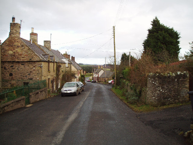
Auchencrow is a small village located in the Scottish Borders region of Berwickshire. It has a population of around 200 residents and is situated near the border with England. The village is surrounded by picturesque countryside, with rolling hills and farmland dominating the landscape.

Auchencrow is a quiet and peaceful village, with a strong sense of community among its residents. There are a few amenities in the village, including a pub, a village hall, and a small primary school. The village is located near the A1 road, providing easy access to nearby towns and cities.

The village has a rich history, with several historic buildings and landmarks scattered throughout the area. Auchencrow is a popular destination for hikers and nature enthusiasts, with many scenic walking trails and outdoor activities available in the surrounding countryside.

Overall, Auchencrow is a charming and idyllic village that offers a tranquil escape from the hustle and bustle of city life. Its natural beauty and friendly community make it a desirable place to live or visit.

If you have any feedback on the listing, please let us know in the comments section below.

Auchencrow Images

Images are sourced within 2km of 55.838964/-2.2356334 or Grid Reference NT8560. Thanks to Geograph Open Source API. All images are credited.

Auchencrow The Craw Inn in the village of Auchencrow, Berwickshire.
Auchencrow
The Craw Inn in the village of Auchencrow, Berwickshire.
Auchencrow View East along the main street in this small village.
Auchencrow
View East along the main street in this small village.
The Craw Inn, Auchencrow 18th century listed building
The Craw Inn, Auchencrow
18th century listed building
Greenburn Cottage, Auchencrow Interesting set of stairs on outside of building, now going nowhere.
Greenburn Cottage, Auchencrow
Interesting set of stairs on outside of building, now going nowhere.
Cottages at Greenburn, Auchencrow
Berwickshire Railway Heading out to the hinterland, the former railway linking Tweeddale with the East Coast main line at Reston. Closed to passenger traffic in 1951, and finally closed and dismantled in 1966.
Berwickshire Railway
Heading out to the hinterland, the former railway linking Tweeddale with the East Coast main line at Reston. Closed to passenger traffic in 1951, and finally closed and dismantled in 1966.
Newmains Arable land near Newmains Farm.
Newmains
Arable land near Newmains Farm.
Fairlaw Farm and road junction just outside Auchencrow.
Fairlaw
Farm and road junction just outside Auchencrow.
Field and small wood, Sunnyside Arable land with small wood above Auchencrow, Berwickshire.
Field and small wood, Sunnyside
Arable land with small wood above Auchencrow, Berwickshire.
Swansfield Former farm with overgrown sheep pens at 170m asl overlooking the A1.
Swansfield
Former farm with overgrown sheep pens at 170m asl overlooking the A1.
Sheep, Swansfield Pastureland above the Eye Water.
Sheep, Swansfield
Pastureland above the Eye Water.
Eye Water Downstream from Howden Bridge.
Eye Water
Downstream from Howden Bridge.
Stoneshiel Hill top field growing a winter sown crop.
Stoneshiel
Hill top field growing a winter sown crop.
Drinking trough, Stoneshiel The ploughed field has recently been grazed by cattle. The galvanised water troughs are a familiar sight, but most are ageing now. They are operated by a ballcock held in the box at the top. Quite an advance in their day, watering cattle can be a problem, given the amount they drink.
Drinking trough, Stoneshiel
The ploughed field has recently been grazed by cattle. The galvanised water troughs are a familiar sight, but most are ageing now. They are operated by a ballcock held in the box at the top. Quite an advance in their day, watering cattle can be a problem, given the amount they drink.
Stoneshiel Hill top field, recently ploughed revealing a rich red soil.
Stoneshiel
Hill top field, recently ploughed revealing a rich red soil.
Cushy Wood Edge of a small wood.
Cushy Wood
Edge of a small wood.
The Craw Inn The 2007 exterior of this rather fine pub.
The Craw Inn
The 2007 exterior of this rather fine pub.
Auchencrow The phone box, at the higher end of the village street.
Auchencrow
The phone box, at the higher end of the village street.
Show me another place!

Auchencrow is located at Grid Ref: NT8560 (Lat: 55.838964, Lng: -2.2356334)

Unitary Authority: The Scottish Borders

Police Authority: The Lothians and Scottish Borders

What 3 Words

///stirs.grew.fled. Near Chirnside, Scottish Borders

Related Wikis

Auchencrow

Auchencrow (Scottish Gaelic: Allt na Crà) is a small village in the Scottish Borders area of Scotland, by the Lammermuir range of hills, and near Reston...

Billie Castle

Billie Castle is a ruined 15th century quadrangular castle, 3 miles (4.8 km) north west of Chirnside, Scottish Borders, Scotland, north of Billiemains...

Reston railway station

Reston is a railway station in the small village of Reston that serves the wider rural parish of Coldingham and nearby small town of Eyemouth in the eastern...

Reston, Scottish Borders

Reston is a village located in the southeast of Scotland, in Berwickshire, Scottish Borders region. The village lies on the western bank of the Eye Water...

Nearby Amenities

Located within 500m of 55.838964,-2.2356334
Auchencrow
Is In Country Code: GB
Is In County: Scottish Borders
Is In Historic County: Berwickshire
Place: village
Wikidata: Q4819394
Wikipedia: en:Auchencrow
Lat/Long: 55.839465/-2.2390633
Bus Stop
Craw Inn
Local Ref: AT
Naptan AtcoCode: 69001174
Naptan Bearing: E
Naptan BusStopType: CUS
Naptan CommonName: Craw Inn
Naptan Indicator: At
Naptan Landmark: Craw Inn
Naptan NaptanCode: 72726725
Naptan Street: Main Street
Naptan Verified: no
Source: naptan_import
Lat/Long: 55.8390949/-2.2369468
Bus Stop
Craw Inn
Bus: yes
Naptan AtcoCode: 69001175
Naptan Bearing: W
Naptan BusStopType: CUS
Naptan CommonName: Craw Inn
Naptan Indicator: Opp
Naptan Landmark: Craw Inn
Naptan NaptanCode: 72726724
Naptan Street: Main Street
Naptan Verified: no
Public Transport: platform
Source: naptan_import
Lat/Long: 55.8390846/-2.2372449
Post Box
Post Box Design: waggon_top
Post Box Type: lamp
Ref: TD14 21
Royal Cypher: GVIR
Royal Cypher Wikidata: Q33102169
Lat/Long: 55.8389372/-2.2360348
Pub
The Craw Inn
Addr Postcode: TD14 5LS
Brewery: yes
Fhrs Id: 1042639
Opening Hours Covid19: restricted
Smoking: outside
Website: https://www.thecrawinn.co.uk/
Lat/Long: 55.8391752/-2.2370808
Defibrillator
Access: yes
Booth: K6
Covered: booth
Defibrillator Location: inside old red phone box in Auchencrow
Disused Amenity: telephone
Emergency: defibrillator
Indoor: yes
Man Made: telephone_box
Opening Hours: 24/7
Ref GB The Circuit: B29992C8-5AA3-470E-9F1B-19C2386F7E10
Lat/Long: 55.8397092/-2.2398469
Bench
Lat/Long: 55.8388273/-2.2347753
Noexit: yes
Lat/Long: 55.8395951/-2.2401473
Noexit: yes
Lat/Long: 55.84005/-2.2408259
Noexit: yes
Lat/Long: 55.8398346/-2.2412488
Give Way
Direction: backward
Lat/Long: 55.842978/-2.2372034
Grit Bin
Access: yes
Material: plastic
Lat/Long: 55.8391384/-2.2373701
Bicycle Repair Station
Fee: no
Opening Hours: 24/7
Lat/Long: 55.8391132/-2.2372849
Advertising: board
Lit: yes
Support: pole
Visibility: area
Lat/Long: 55.8391204/-2.2372983
Power: pole
Lat/Long: 55.8412338/-2.2377911
Power: pole
Lat/Long: 55.841041/-2.2366297
Power: pole
Lat/Long: 55.8408377/-2.2354227
Power: pole
Lat/Long: 55.8406194/-2.2341326
Power: pole
Lat/Long: 55.8403859/-2.232872
Power: pole
Lat/Long: 55.8401465/-2.2313377
Power: pole
Lat/Long: 55.8398513/-2.2297177
Power: pole
Lat/Long: 55.8399401/-2.228508
Power: pole
Lat/Long: 55.8414558/-2.2389259
Power: pole
Lat/Long: 55.8416441/-2.2400051
Power: pole
Lat/Long: 55.8418794/-2.2414068
Power: pole
Lat/Long: 55.8405842/-2.2331021
Power: pole
Lat/Long: 55.8412337/-2.2333171
Power: pole
Lat/Long: 55.8418565/-2.2335213
Power: pole
Lat/Long: 55.8425023/-2.2337363
Power: pole
Lat/Long: 55.839534/-2.2387281
Power: pole
Lat/Long: 55.8398286/-2.2382358
Power: pole
Lat/Long: 55.8402873/-2.2374662
The data included in this document is from www.openstreetmap.org. The data is made available under ODbL.

Have you been to Auchencrow?

Leave your review of Auchencrow below (or comments, questions and feedback).