Bildeston Grove
Wood, Forest in Suffolk Babergh
England
Bildeston Grove

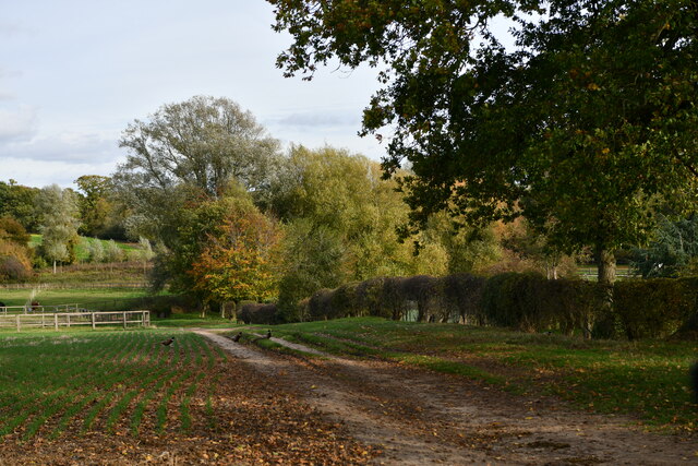
Bildeston Grove is a picturesque wood located in the county of Suffolk, England. Nestled in the heart of the countryside, this enchanting forest spans approximately 100 acres and is a haven for nature enthusiasts and outdoor adventurers alike.
The grove boasts a diverse range of tree species, including oak, beech, birch, and pine. These towering giants create a dense canopy that provides shade and shelter to a myriad of flora and fauna. Walking along the well-maintained trails, visitors will be greeted by a breathtaking display of wildflowers, ferns, and mosses that carpet the forest floor.
The tranquil atmosphere of Bildeston Grove offers a respite from the hustle and bustle of everyday life. Birdsong fills the air, as numerous avian species call this woodland their home. Keen-eyed visitors may catch a glimpse of woodpeckers, owls, or even the elusive red squirrel, which is known to inhabit the area.
The grove is a popular destination for outdoor activities such as hiking, cycling, and picnicking. With its extensive network of trails, visitors can explore the wood at their own pace, discovering hidden gems along the way. The peaceful setting also makes Bildeston Grove an ideal spot for mindfulness and meditation, allowing individuals to connect with nature and find inner tranquility.
Bildeston Grove is not only a place of natural beauty but also of historical significance. The wood has been carefully managed for centuries, with evidence of human activity dating back to medieval times. Remnants of old boundary walls and ditches can still be seen, adding an extra layer of intrigue to this already captivating destination.
In summary, Bildeston Grove in Suffolk is a captivating wood that offers a sanctuary of tranquility and natural beauty. With its diverse range of flora and fauna, well-maintained trails, and historical significance, it is a must-visit destination for nature lovers and history enthusiasts alike.
If you have any feedback on the listing, please let us know in the comments section below.
Bildeston Grove Images
Images are sourced within 2km of 52.103289/0.89883138 or Grid Reference TL9848. Thanks to Geograph Open Source API. All images are credited.


Bildeston Grove is located at Grid Ref: TL9848 (Lat: 52.103289, Lng: 0.89883138)
Administrative County: Suffolk
District: Babergh
Police Authority: Suffolk
What 3 Words
///positives.good.wool. Near Bildeston, Suffolk
Nearby Locations
Related Wikis

Cosford Hundred
Cosford was a hundred of Suffolk, consisting of 30,712 acres (124.29 km2).The hundred consisted of Hadleigh, the only town of any size, and seventeen other...

Bildeston
Bildeston is a village and civil parish in the Babergh district of Suffolk, England. Located around 5 miles (8 km) north of Hadleigh, in 2005 it had a...

Chelsworth
Chelsworth is a village and civil parish in Suffolk, England. It lies on the B1115 road, 10 miles in either direction from Sudbury and Stowmarket. It is...

Hitcham, Suffolk
Hitcham is a village and civil parish in Suffolk, England. Located on the B1115 road, between Hadleigh and Stowmarket, it is part of Babergh district....

Kettlebaston
Kettlebaston is a village and a civil parish with just over 30 inhabitants in the Babergh district of Suffolk, England, located around 3 miles (5 km) east...

Nedging
Nedging is a village and former civil parish on the B1115 road, now in the parish of Nedging-with-Naughton, in the Babergh district, in the county of Suffolk...
Semer, Suffolk
Semer is a small village and civil parish in Suffolk, England. Located adjacent to a bridge over the River Brett on the B1115 between Hadleigh and Stowmarket...
Monks Eleigh
Monks Eleigh is a village and a civil parish in Babergh, Suffolk, United Kingdom, situated on the tributary to the River Brett in a rural area. The parish...
Nearby Amenities
Located within 500m of 52.103289,0.89883138Have you been to Bildeston Grove?
Leave your review of Bildeston Grove below (or comments, questions and feedback).