Fornham All Saints

Settlement in Suffolk West Suffolk

England

Fornham All Saints

The A134 at Fornham St Martin
The A134 at Fornham St Martin Credit: Robert Edwards

Fornham All Saints is a picturesque village located in the county of Suffolk, England. Situated just three miles northwest of Bury St Edmunds, it is a small and close-knit community with a population of around 500 residents.

The village is known for its rich history, with evidence of human settlement dating back to the Roman times. The name "Fornham" is derived from the Old English words "forn" meaning old and "ham" meaning homestead, indicating the village's ancient roots.

One of the most prominent features of Fornham All Saints is its beautiful church, St. Genevieve's. This Grade I listed building dates back to the 14th century and showcases stunning architecture and intricate stained glass windows.

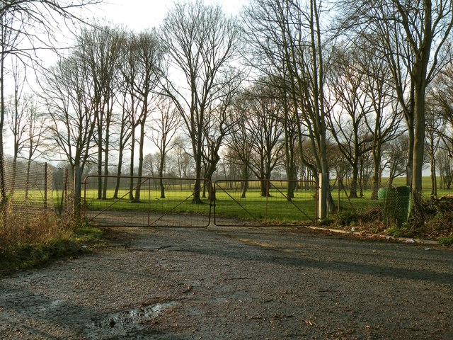
The village is surrounded by picturesque countryside, offering breathtaking views and ample opportunities for outdoor activities such as walking, cycling, and horse riding. The River Lark also runs through the village, providing a tranquil setting for fishing and boating enthusiasts.

Fornham All Saints is well-served by local amenities, including a village hall, primary school, and a pub, The Woolpack Inn, which is a popular gathering place for locals and visitors alike.

The village hosts various community events throughout the year, including an annual summer fete and a Christmas market, which brings the community together and provides opportunities for socializing and fundraising.

Overall, Fornham All Saints offers a charming and idyllic rural setting, with a strong sense of community and a rich historical heritage, making it an attractive place to live or visit for those seeking a peaceful and picturesque retreat in Suffolk.

If you have any feedback on the listing, please let us know in the comments section below.

Fornham All Saints Images

Images are sourced within 2km of 52.273532/0.68995949 or Grid Reference TL8367. Thanks to Geograph Open Source API. All images are credited.

The A134 at Fornham St Martin
Blackthorn Walk, Bury St Edmunds
River Lark north of Tollgate Bridge The view in the opposite direction to <a href="https://www.geograph.org.uk/photo/2564287">TL8566 : River Lark passes under Tollgate bridge</a>.
River Lark north of Tollgate Bridge
The view in the opposite direction to TL8566 : River Lark passes under Tollgate bridge.
St.Olaves Shopping Precint Local shops on St.Olaves Road Bury St.Edmunds, Suffolk.
St.Olaves Shopping Precint
Local shops on St.Olaves Road Bury St.Edmunds, Suffolk.
Golfer Golfer at the Bury St.Edmunds Golf Club Bury St.Edmunds, Suffolk.
Golfer
Golfer at the Bury St.Edmunds Golf Club Bury St.Edmunds, Suffolk.
Westley Road Looking south west along Westley Road that runs between the village of Fornham All Saints and the A.14 near to Bury St.Edmunds, Suffolk.
Westley Road
Looking south west along Westley Road that runs between the village of Fornham All Saints and the A.14 near to Bury St.Edmunds, Suffolk.
Westley Road Looking south west along Westley Road near to Bury St.Edmunds, Suffolk.
Westley Road
Looking south west along Westley Road near to Bury St.Edmunds, Suffolk.
Farmers Gated Track Farmers gated track near to Bury St.Edmunds, Suffolk.
Farmers Gated Track
Farmers gated track near to Bury St.Edmunds, Suffolk.
Crossroads Crossroads near to Culford, Suffolk.
Crossroads
Crossroads near to Culford, Suffolk.
Mill Lane Mill Lane near to Hengrave, Suffolk.
Mill Lane
Mill Lane near to Hengrave, Suffolk.
Thetford Road near Fornham St. Martin This is part of the B1106.
Thetford Road near Fornham St. Martin
This is part of the B1106.
Part of Fornham Park The entrance leads to a sewage works.
Part of Fornham Park
The entrance leads to a sewage works.
Part of the B1106 just south of Culford
Mill Lane near Hengrave
Road Junction Minor road onto the B1106 near to Culford, Suffolk.
Road Junction
Minor road onto the B1106 near to Culford, Suffolk.
Farmland near Risby with Partridge and Pheasant
Hyde Road, towards Hyde Wood
Ploughed Farmland, outside Fornham All Saints
Show me another place!

Fornham All Saints is located at Grid Ref: TL8367 (Lat: 52.273532, Lng: 0.68995949)

Administrative County: Suffolk

District: West Suffolk

Police Authority: Suffolk

What 3 Words

///donation.handover.views. Near Bury St Edmunds, Suffolk

Nearby Locations

Fornham All Saints

Related Wikis

Fornham All Saints

Fornham All Saints is a village and civil parish in Suffolk, England in the West Suffolk district. It is north-northwest of the town of Bury St Edmunds...
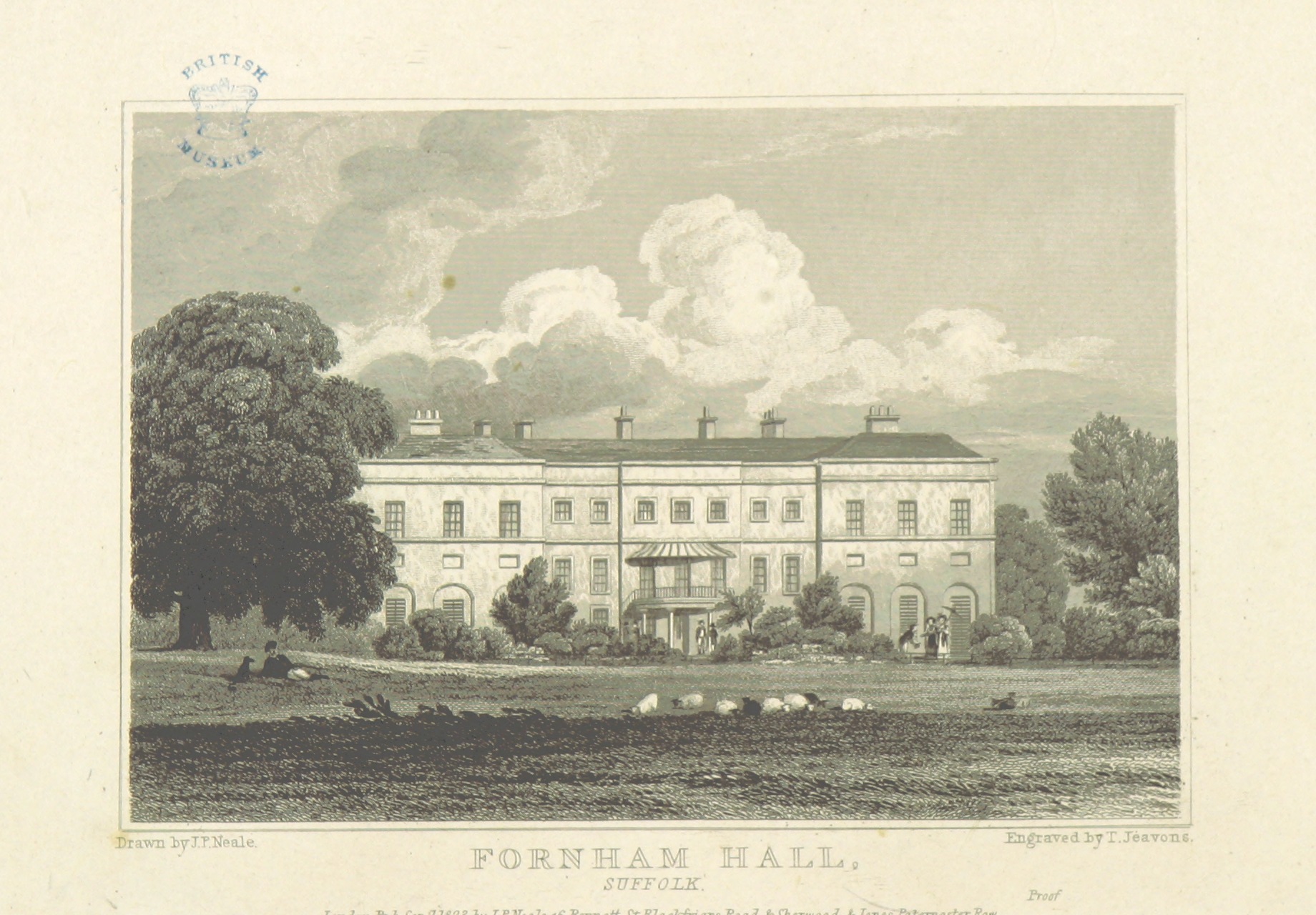
Fornham Hall

Fornham Hall was a large 18th-century country house near Bury St Edmunds. It was demolished in 1957. The Estate included manorial land is part of the parish...

Fornham St Genevieve

Fornham St Genevieve is a village and civil parish in the West Suffolk district of Suffolk in eastern England. It is one of a trio of contiguous villages...
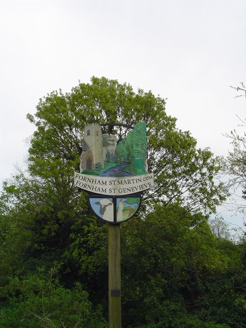
Fornham St Martin

Fornham St Martin is a village and civil parish in the West Suffolk district of Suffolk in eastern England. Located on the northern outskirts of Bury St...
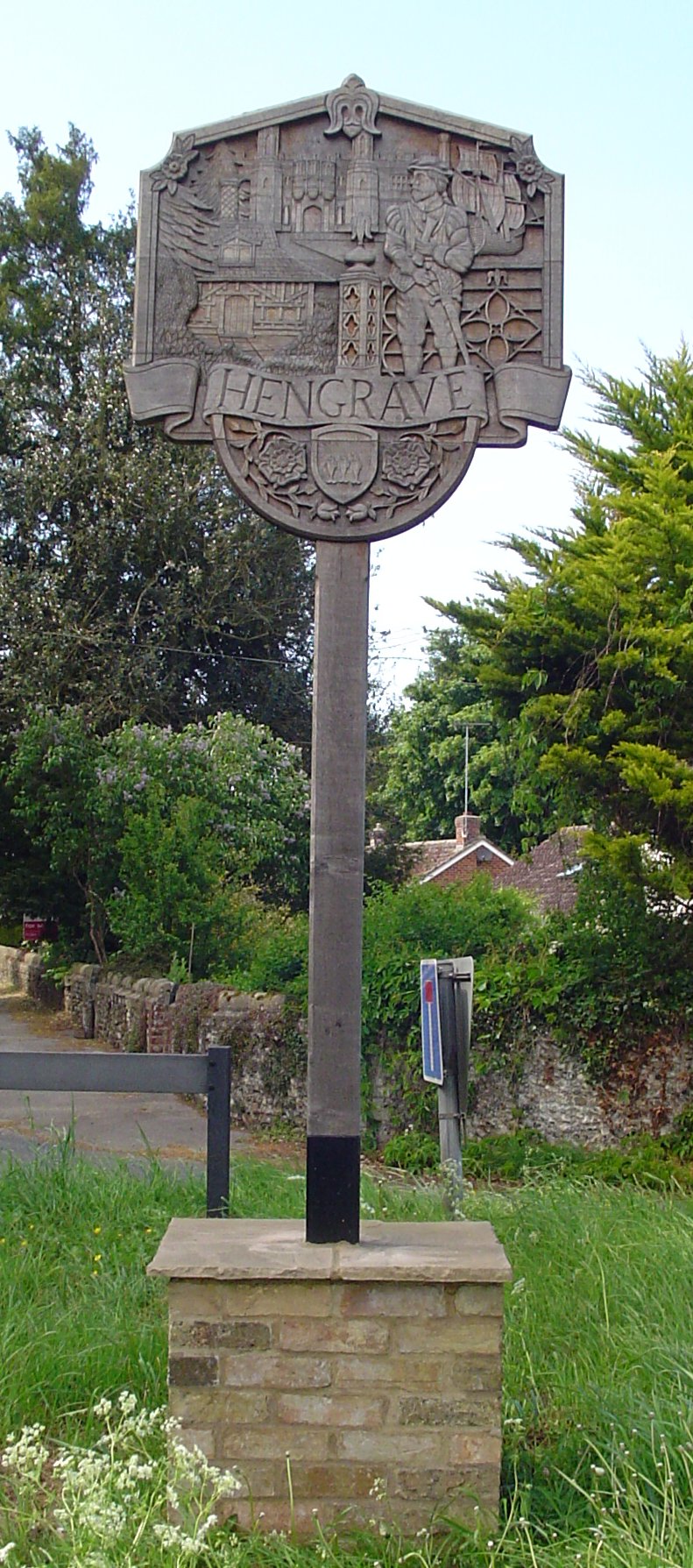
Hengrave

Hengrave is a small village and civil parish in the West Suffolk district, in the county of Suffolk, England. It is to the North the town of Bury St Edmunds...

Church of St John Lateran, Hengrave

The Church of St John Lateran, Hengrave is the former parish church of Hengrave, Suffolk. In 1589 this parish was consolidated with that of adjacent Flempton...
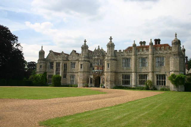
Hengrave Hall

Hengrave Hall is a Grade I listed Tudor manor house in Hengrave near Bury St. Edmunds in Suffolk, England and was the seat of the Kitson and Gage families...

St Benedict's Catholic School

St Benedict's Catholic School is a coeducational Roman Catholic secondary school and sixth form in Bury St Edmunds, Suffolk, England. Opened in 1967, the...

Nearby Amenities

Located within 500m of 52.273532,0.68995949
Mini Roundabout
Direction: clockwise
Lat/Long: 52.2735885/0.689992
Fornham All Saints
Place: village
Source: survey
Wikidata: Q612797
Lat/Long: 52.2735585/0.6906814
Mini Roundabout
Direction: clockwise
Lat/Long: 52.2733341/0.6900304
Bus Stop
Three Kings Roundabout
Naptan AtcoCode: 390050636
Naptan Bearing: SE
Naptan CommonName: Three Kings Roundabout
Naptan Indicator: E-bound
Naptan Landmark: Chapel
Naptan NaptanCode: sufgjgat
Naptan Street: A1101
Naptan Verified: no
Source: naptan_import
Lat/Long: 52.27328/0.6903351
Three Kings Roundabout
Naptan AtcoCode: 390050637
Naptan Bearing: NW
Naptan BusStopType: CUS
Naptan CommonName: Three Kings Roundabout
Naptan Indicator: W-bound
Naptan Landmark: Chapel
Naptan NaptanCode: sufgjgaw
Naptan Street: A1101
Naptan Verified: no
Source: naptan_import
Lat/Long: 52.2731432/0.6903085
Three Kings Roundabout
Naptan AtcoCode: 390050638
Naptan Bearing: S
Naptan BusStopType: CUS
Naptan CommonName: Three Kings Roundabout
Naptan Indicator: S-bound
Naptan Landmark: Sunnyside
Naptan NaptanCode: sufgjgda
Naptan Street: Tut Hill
Naptan Verified: no
Source: naptan_import
Lat/Long: 52.2731608/0.6898514
Three Kings Roundabout
Naptan AtcoCode: 390050639
Naptan Bearing: N
Naptan BusStopType: CUS
Naptan CommonName: Three Kings Roundabout
Naptan Indicator: N-bound
Naptan Landmark: Sunnyside
Naptan NaptanCode: sufgjgdg
Naptan Street: Tut Hill
Naptan Verified: no
Source: naptan_import
Lat/Long: 52.2732047/0.689741
Three Kings Roundabout
Naptan AtcoCode: 390050640
Naptan Bearing: W
Naptan BusStopType: CUS
Naptan CommonName: Three Kings Roundabout
Naptan Indicator: adj
Naptan Landmark: Three Kings Roundabout
Naptan NaptanCode: sufgjgdj
Naptan Street: Hengrave Road
Naptan Verified: no
Source: naptan_import
Lat/Long: 52.2736091/0.6897022
Three Kings Roundabout
Naptan AtcoCode: 390050641
Naptan Bearing: E
Naptan BusStopType: CUS
Naptan CommonName: Three Kings Roundabout
Naptan Indicator: Opp
Naptan Landmark: Three Kings Roundabout
Naptan NaptanCode: sufgjgdm
Naptan Street: Hengrave Road
Naptan Verified: no
Source: naptan_import
Lat/Long: 52.2737092/0.6896496
Bus Stop
Post Office
Local Ref: NR
Naptan AtcoCode: 390050644
Naptan Bearing: E
Naptan CommonName: Post Office
Naptan Indicator: nr
Naptan Landmark: Post Office
Naptan NaptanCode: sufgjgdw
Naptan Street: B1106
Shelter: yes
Source: naptan_import;survey
Lat/Long: 52.2767588/0.6950369
Bus Stop
The Green
Naptan AtcoCode: 390050646
Naptan Bearing: N
Naptan CommonName: The Green
Naptan Indicator: adj
Naptan Landmark: The Green
Naptan NaptanCode: sufgjgjd
Naptan Street: B1106
Public Transport: platform
Source: naptan_import
Lat/Long: 52.2749417/0.6914005
Bus Stop
The Green
Naptan AtcoCode: 390050647
Naptan Bearing: S
Naptan CommonName: The Green
Naptan Indicator: opp
Naptan Landmark: The Green
Naptan NaptanCode: sufgjgjg
Naptan Street: B1106
Shelter: yes
Source: naptan_import;survey
Lat/Long: 52.2749502/0.6912804
Pipeline: marker
Pipeline Type: oil
Ref: MP 3982
Lat/Long: 52.2717844/0.6929345
Post Box
Collection Times: Mo-Fr 16:45; Sa 11:30
Post Box Mounting: pier
Post Box Type: lamp
Ref: IP28 8164
Royal Cypher: EIIR
Royal Cypher Wikidata: Q33102113
Lat/Long: 52.2735793/0.6896197
Historic: memorial
Lat/Long: 52.2739044/0.6902792
Post Box
Collection Times: Mo-Fr 09:00; Sa 07:00
Post Box Design: type_a
Post Box Type: pillar
Ref: IP28 8261D
Royal Cypher: EIIR
Royal Cypher Wikidata: Q33102113
Lat/Long: 52.2767206/0.6939032
Fornham All Saints
Man Made: village_sign
Lat/Long: 52.2757209/0.691934
E Salon
Facebook: https://www.facebook.com/ESalon17/
Shop: hairdresser
Lat/Long: 52.2761393/0.6933366
Defibrillator
Addr Postcode: IP28 6JX
Booth: K6
Colour: red
Covered: booth
Defibrillator Location: Inside old red telephone box outside Fornham All Saints Village Hall.
Disused Amenity: telephone
Emergency: defibrillator
Listed Status: Grade II
Man Made: telephone_box
Ref: CHT-9855
Lat/Long: 52.2750954/0.6911806
Waste Basket
Lat/Long: 52.2751479/0.6912195
Entrance: main
Lat/Long: 52.2751914/0.691249
Pipeline: marker
Pipeline Type: oil
Lat/Long: 52.2713074/0.6903524
Pipeline: marker
Pipeline Type: oil
Lat/Long: 52.2717459/0.6927514
Bury Rd Fornham All Saints
Grid Reference: TL 83722 67236
Operator: UK Power Networks
Power: substation
Lat/Long: 52.2726701/0.6912988
Recycling
Recycling Glass Bottles: yes
Recycling Type: container
Lat/Long: 52.272832/0.6907706
Entrance: main
Lat/Long: 52.2728952/0.6905536
Pipeline: marker
Substance: oil
Support: ground
Lat/Long: 52.2708095/0.687511
Pipeline: marker
Substance: oil
Support: ground
Lat/Long: 52.2707843/0.6873592
Waste Basket
Waste: dog_excrement
Lat/Long: 52.2749731/0.691215
Bench
Lat/Long: 52.2745117/0.6906755
Waste Basket
Waste: dog_excrement
Lat/Long: 52.2741678/0.6904771
Bench
Lat/Long: 52.2740924/0.6903684
The Fleur
Shop: florist
Lat/Long: 52.2760913/0.6927327
Addr City: Bury St Edmunds
Addr Housename: West End Cottage
Addr Street: Tut Hill
Addr Village: Fornham All Saints
Fixme: Check location
Lat/Long: 52.2721869/0.6886545
Bench
Lat/Long: 52.2761456/0.6922664
The data included in this document is from www.openstreetmap.org. The data is made available under ODbL.

Have you been to Fornham All Saints?

Leave your review of Fornham All Saints below (or comments, questions and feedback).