Park Spinney

Wood, Forest in Kent Ashford

England

Park Spinney

The Greensand Way The Greensand Way is a long distance walk of 108 miles (174 km) in Southeast England, from Haslemere in Surrey to Hamstreet in Kent. It follows the Greensand Ridge along the Surrey Hills and Chart Hills. The route is mostly rural, passing through woods and alongside fruit orchards and hop farms in Kent. and links with the Stour Valley Walk near Pluckley in Kent.

See <span class="nowrap"><a title="http://www.kent.gov.uk/leisure_and_culture/countryside_and_coast/walking/greensand_way.aspx" rel="nofollow ugc noopener" href="http://www.kent.gov.uk/leisure_and_culture/countryside_and_coast/walking/greensand_way.aspx">Link</a><img style="margin-left:2px;" alt="External link" title="External link - shift click to open in new window" src="https://s1.geograph.org.uk/img/external.png" width="10" height="10"/></span> for more details. See also <span class="nowrap"><a title="http://www.walkingpages.co.uk/trails_paths/LDP_greensandway.htm" rel="nofollow ugc noopener" href="http://www.walkingpages.co.uk/trails_paths/LDP_greensandway.htm">Link</a><img style="margin-left:2px;" alt="External link" title="External link - shift click to open in new window" src="https://s1.geograph.org.uk/img/external.png" width="10" height="10"/></span> for more mapping details.
The Greensand Way Credit: N Chadwick

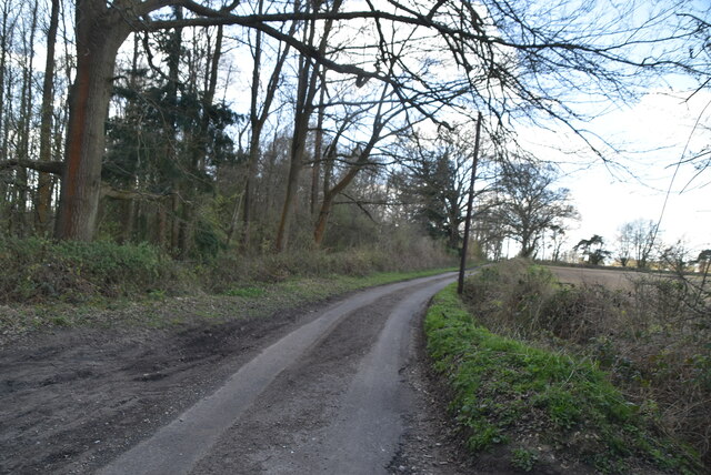
Park Spinney is a picturesque woodland located in Kent, England. Covering an area of approximately 50 acres, it is a popular destination for nature enthusiasts and outdoor lovers. The spinney is nestled within the larger Blean Woods, which is known for its diverse flora and fauna.

This woodland is characterized by its dense canopy of trees, predominantly consisting of oak, beech, and ash. The forest floor is adorned with a carpet of wildflowers, creating a vibrant and colorful atmosphere during the spring and summer months. The area is also home to a variety of wildlife, including deer, rabbits, and a multitude of bird species.

The park offers several walking trails that meander through the woodland, allowing visitors to explore its natural beauty. These trails are well-maintained and suitable for all ages and abilities. There are also designated picnic areas and benches scattered throughout the spinney, providing a perfect spot for a leisurely lunch amidst the tranquil surroundings.

Park Spinney is a haven for nature photography, with its stunning landscapes and abundant wildlife offering endless opportunities for capturing the beauty of the area. It is also a popular spot for birdwatching, as it attracts a wide range of species throughout the year.

Managed by local conservation organizations, Park Spinney is dedicated to preserving and enhancing the natural environment. Regular maintenance and conservation efforts ensure that the woodland remains a thriving ecosystem and a cherished recreational space for visitors to enjoy.

If you have any feedback on the listing, please let us know in the comments section below.

Park Spinney Images

Images are sourced within 2km of 51.162575/0.81148469 or Grid Reference TQ9644. Thanks to Geograph Open Source API. All images are credited.

The Greensand Way The Greensand Way is a long distance walk of 108 miles (174 km) in Southeast England, from Haslemere in Surrey to Hamstreet in Kent. It follows the Greensand Ridge along the Surrey Hills and Chart Hills. The route is mostly rural, passing through woods and alongside fruit orchards and hop farms in Kent. and links with the Stour Valley Walk near Pluckley in Kent.

See <span class="nowrap"><a title="http://www.kent.gov.uk/leisure_and_culture/countryside_and_coast/walking/greensand_way.aspx" rel="nofollow ugc noopener" href="http://www.kent.gov.uk/leisure_and_culture/countryside_and_coast/walking/greensand_way.aspx">Link</a><img style="margin-left:2px;" alt="External link" title="External link - shift click to open in new window" src="https://s1.geograph.org.uk/img/external.png" width="10" height="10"/></span> for more details. See also <span class="nowrap"><a title="http://www.walkingpages.co.uk/trails_paths/LDP_greensandway.htm" rel="nofollow ugc noopener" href="http://www.walkingpages.co.uk/trails_paths/LDP_greensandway.htm">Link</a><img style="margin-left:2px;" alt="External link" title="External link - shift click to open in new window" src="https://s1.geograph.org.uk/img/external.png" width="10" height="10"/></span> for more mapping details.
The Greensand Way
The Greensand Way is a long distance walk of 108 miles (174 km) in Southeast England, from Haslemere in Surrey to Hamstreet in Kent. It follows the Greensand Ridge along the Surrey Hills and Chart Hills. The route is mostly rural, passing through woods and alongside fruit orchards and hop farms in Kent. and links with the Stour Valley Walk near Pluckley in Kent. See LinkExternal link for more details. See also LinkExternal link for more mapping details.
Ram Lane
Ram Lane
Ram Lane
Ram Lane
Coldham Wood
Coldham Wood
Footpath
Footpath
Coppicing Coppicing is a management technique of cutting trees and shrubs to ground level allowing vigorous regrowth and a sustainable supply of timber for future generations. 
Trees and shrubs that are cut down in this way can produce shoots that grow over 30cm in a week.
The benefits of coppicing are varied, including promoting ground vegetation (by letting light in), raw materials for thatching, fencing, kindling and charcoal making. Also coppiced trees live longer than non coppiced trees. All trees can be coppiced, but hazel, ash, lime and beech are common.
Coppicing
Coppicing is a management technique of cutting trees and shrubs to ground level allowing vigorous regrowth and a sustainable supply of timber for future generations. Trees and shrubs that are cut down in this way can produce shoots that grow over 30cm in a week. The benefits of coppicing are varied, including promoting ground vegetation (by letting light in), raw materials for thatching, fencing, kindling and charcoal making. Also coppiced trees live longer than non coppiced trees. All trees can be coppiced, but hazel, ash, lime and beech are common.
Footbridge over Great Stour The Greensand Way is a long distance walk of 108 miles (174 km) in Southeast England, from Haslemere in Surrey to Hamstreet in Kent. It follows the Greensand Ridge along the Surrey Hills and Chart Hills. The route is mostly rural, passing through woods and alongside fruit orchards and hop farms in Kent. and links with the Stour Valley Walk near Pluckley in Kent.

See <span class="nowrap"><a title="http://www.kent.gov.uk/leisure_and_culture/countryside_and_coast/walking/greensand_way.aspx" rel="nofollow ugc noopener" href="http://www.kent.gov.uk/leisure_and_culture/countryside_and_coast/walking/greensand_way.aspx">Link</a><img style="margin-left:2px;" alt="External link" title="External link - shift click to open in new window" src="https://s1.geograph.org.uk/img/external.png" width="10" height="10"/></span> for more details. See also <span class="nowrap"><a title="http://www.walkingpages.co.uk/trails_paths/LDP_greensandway.htm" rel="nofollow ugc noopener" href="http://www.walkingpages.co.uk/trails_paths/LDP_greensandway.htm">Link</a><img style="margin-left:2px;" alt="External link" title="External link - shift click to open in new window" src="https://s1.geograph.org.uk/img/external.png" width="10" height="10"/></span> for more mapping details.
Footbridge over Great Stour
The Greensand Way is a long distance walk of 108 miles (174 km) in Southeast England, from Haslemere in Surrey to Hamstreet in Kent. It follows the Greensand Ridge along the Surrey Hills and Chart Hills. The route is mostly rural, passing through woods and alongside fruit orchards and hop farms in Kent. and links with the Stour Valley Walk near Pluckley in Kent. See LinkExternal link for more details. See also LinkExternal link for more mapping details.
Great Stour The river has four main tributaries, the Great Stour rises in Lenham and East Stour River from Sellindge, meeting at Ashford, when they turn into the Great Stour. 

The Great Stour continues through Canterbury to Plucks Gutter where it meets two further tributaries, the River Wantsum and Little Stour to become the River Stour. The river continues across Ash Level through Sandwich and out to Pegwell Bay where it meets the North Sea.

Wikipedia <span class="nowrap"><a title="http://en.wikipedia.org/wiki/River_Stour,_Kent" rel="nofollow ugc noopener" href="http://en.wikipedia.org/wiki/River_Stour,_Kent">Link</a><img style="margin-left:2px;" alt="External link" title="External link - shift click to open in new window" src="https://s1.geograph.org.uk/img/external.png" width="10" height="10"/></span>
Great Stour
The river has four main tributaries, the Great Stour rises in Lenham and East Stour River from Sellindge, meeting at Ashford, when they turn into the Great Stour. The Great Stour continues through Canterbury to Plucks Gutter where it meets two further tributaries, the River Wantsum and Little Stour to become the River Stour. The river continues across Ash Level through Sandwich and out to Pegwell Bay where it meets the North Sea. Wikipedia LinkExternal link
Stour Valley Walk The Stour Valley Walk is a 58 mile (93km) route through the Low Weald and North Downs, giving you access to some the most attractive parts of East Kent. Rolling grassland, woods, marshes, peat bog, orchards and picturesque villages make this a memorable journey which can be completed over a long weekend or in shorter sections. The symbol of the Stour Valley Walk is the heron.
See <span class="nowrap"><a title="http://www.kent.gov.uk/leisure-and-culture/explore-kent/walking/stour-valley-walk.htm" rel="nofollow ugc noopener" href="http://www.kent.gov.uk/leisure-and-culture/explore-kent/walking/stour-valley-walk.htm">Link</a><img style="margin-left:2px;" alt="External link" title="External link - shift click to open in new window" src="https://s1.geograph.org.uk/img/external.png" width="10" height="10"/></span> for more details.
Stour Valley Walk
The Stour Valley Walk is a 58 mile (93km) route through the Low Weald and North Downs, giving you access to some the most attractive parts of East Kent. Rolling grassland, woods, marshes, peat bog, orchards and picturesque villages make this a memorable journey which can be completed over a long weekend or in shorter sections. The symbol of the Stour Valley Walk is the heron. See LinkExternal link for more details.
Reservoir embankment
Ditch by Greensand Way
Waymarker, Greensand Way The Greensand Way is a long distance walk of 108 miles (174 km) in Southeast England, from Haslemere in Surrey to Hamstreet in Kent. It follows the Greensand Ridge along the Surrey Hills and Chart Hills. The route is mostly rural, passing through woods and alongside fruit orchards and hop farms in Kent. and links with the Stour Valley Walk near Pluckley in Kent.

See <span class="nowrap"><a title="http://www.kent.gov.uk/leisure_and_culture/countryside_and_coast/walking/greensand_way.aspx" rel="nofollow ugc noopener" href="http://www.kent.gov.uk/leisure_and_culture/countryside_and_coast/walking/greensand_way.aspx">Link</a><img style="margin-left:2px;" alt="External link" title="External link - shift click to open in new window" src="https://s1.geograph.org.uk/img/external.png" width="10" height="10"/></span> for more details. See also <span class="nowrap"><a title="http://www.walkingpages.co.uk/trails_paths/LDP_greensandway.htm" rel="nofollow ugc noopener" href="http://www.walkingpages.co.uk/trails_paths/LDP_greensandway.htm">Link</a><img style="margin-left:2px;" alt="External link" title="External link - shift click to open in new window" src="https://s1.geograph.org.uk/img/external.png" width="10" height="10"/></span> for more mapping details.
Waymarker, Greensand Way
The Greensand Way is a long distance walk of 108 miles (174 km) in Southeast England, from Haslemere in Surrey to Hamstreet in Kent. It follows the Greensand Ridge along the Surrey Hills and Chart Hills. The route is mostly rural, passing through woods and alongside fruit orchards and hop farms in Kent. and links with the Stour Valley Walk near Pluckley in Kent. See LinkExternal link for more details. See also LinkExternal link for more mapping details.
Rough grassland near Hothfield Common
Pond, Hothfield Common 83 hectares of heathland and lowland valley bogs with river side, meadows and secondary woodland.  
Jointly owned by Ashford Borough Council and Kent Wildlife Trust, Hothfield Heathlands contains Kent’s last four valley bogs and one of its few remaining fragments of open heath with patches of acid grassland.
Pond, Hothfield Common
83 hectares of heathland and lowland valley bogs with river side, meadows and secondary woodland. Jointly owned by Ashford Borough Council and Kent Wildlife Trust, Hothfield Heathlands contains Kent’s last four valley bogs and one of its few remaining fragments of open heath with patches of acid grassland.
Woodland, Hothfield Common Hothfield is a village just off the A20, west of Ashford. On the edge of the village is Hothfield Heathlands and Hothfield Bogs, a SSSI and nature reserve. The village services include a church, village hall, school and Post Office.
Woodland, Hothfield Common
Hothfield is a village just off the A20, west of Ashford. On the edge of the village is Hothfield Heathlands and Hothfield Bogs, a SSSI and nature reserve. The village services include a church, village hall, school and Post Office.
Greensand Way, Hothfield Common The Greensand Way is a long distance walk of 108 miles (174 km) in Southeast England, from Haslemere in Surrey to Hamstreet in Kent. It follows the Greensand Ridge along the Surrey Hills and Chart Hills. The route is mostly rural, passing through woods and alongside fruit orchards and hop farms in Kent. and links with the Stour Valley Walk near Pluckley in Kent.

See <span class="nowrap"><a title="http://www.kent.gov.uk/leisure_and_culture/countryside_and_coast/walking/greensand_way.aspx" rel="nofollow ugc noopener" href="http://www.kent.gov.uk/leisure_and_culture/countryside_and_coast/walking/greensand_way.aspx">Link</a><img style="margin-left:2px;" alt="External link" title="External link - shift click to open in new window" src="https://s1.geograph.org.uk/img/external.png" width="10" height="10"/></span> for more details. See also <span class="nowrap"><a title="http://www.walkingpages.co.uk/trails_paths/LDP_greensandway.htm" rel="nofollow ugc noopener" href="http://www.walkingpages.co.uk/trails_paths/LDP_greensandway.htm">Link</a><img style="margin-left:2px;" alt="External link" title="External link - shift click to open in new window" src="https://s1.geograph.org.uk/img/external.png" width="10" height="10"/></span> for more mapping details.
Greensand Way, Hothfield Common
The Greensand Way is a long distance walk of 108 miles (174 km) in Southeast England, from Haslemere in Surrey to Hamstreet in Kent. It follows the Greensand Ridge along the Surrey Hills and Chart Hills. The route is mostly rural, passing through woods and alongside fruit orchards and hop farms in Kent. and links with the Stour Valley Walk near Pluckley in Kent. See LinkExternal link for more details. See also LinkExternal link for more mapping details.
Show me another place!

Park Spinney is located at Grid Ref: TQ9644 (Lat: 51.162575, Lng: 0.81148469)

Administrative County: Kent

District: Ashford

Police Authority: Kent

What 3 Words

///summaries.conjured.overpaid. Near Ashford, Kent

Related Wikis

Hothfield

Hothfield is a village and civil parish in the Ashford Borough of Kent, England and is 3 miles north-west of Ashford on the A20. It is completely split...

Godinton House

Godinton House (also known as Godinton House and Gardens or Godinton Park) is a stately home in the parish of Great Chart, owned by a non-profit-making...

Hothfield Common

Hothfield Common is a 56.5-hectare (140-acre) biological Site of Special Scientific Interest north-east of Ashford in Kent. It is also a Local Nature...

Hoad's Wood

Hoad's Wood is an 80.5-hectare (199-acre) biological Site of Special Scientific Interest west of Ashford in Kent.Natural England described the woodland...

Hothfield railway station

Hothfield railway station (later Hothfield Halt) was a railway station on the Maidstone Line at Hothfield, Kent. It was situated between Ashford and Charing...

Godinton

Godinton (sometimes known as Godinton Park) is a suburb of Ashford, Kent in England, with its stately home Godinton House within its outskirts. Godinton...

Little Chart

Little Chart is a village and civil parish, situated 4 miles (6.4 km) north-west of Ashford in Kent, South East England. The parish lies south of the M20...

Great Chart

Great Chart is a village and former civil parish, now in the parish of Great Chart with Singleton, in the Ashford borough of Kent, England. The parish...

Nearby Amenities

Located within 500m of 51.162575,0.81148469
Power: pole
Lat/Long: 51.1610722/0.8051187
Power: pole
Lat/Long: 51.1607055/0.8066127
Power: pole
Lat/Long: 51.1603405/0.8080396
Power: pole
Lat/Long: 51.1601538/0.8092412
Power: pole
Lat/Long: 51.1599318/0.8104455
Power: pole
Lat/Long: 51.1597181/0.8117732
Power: pole
Lat/Long: 51.1594994/0.8131331
Power: pole
Lat/Long: 51.1589662/0.8143803
Noexit: yes
Lat/Long: 51.1632609/0.8077543
Noexit: yes
Lat/Long: 51.1632578/0.8076914
The data included in this document is from www.openstreetmap.org. The data is made available under ODbL.

Have you been to Park Spinney?

Leave your review of Park Spinney below (or comments, questions and feedback).