Lancefield Wood

Wood, Forest in Kent Ashford

England

Lancefield Wood

Bluebells at Great Piper Wood Still going strong, a woodland awash with bluebells by footpath between Ingleden and Brissenden.

<a href="https://www.geograph.org.uk/photo/2393230">TQ9034 : Bluebells at Great Piper Wood</a>
Bluebells at Great Piper Wood Credit: Oast House Archive

Lancefield Wood is a picturesque forest located in the county of Kent, England. Spanning an area of approximately 100 acres, it is a popular destination for nature lovers and outdoor enthusiasts. The wood is known for its diverse range of flora and fauna, providing a haven for various wildlife species.

The forest boasts a mixture of deciduous and evergreen trees, including oak, beech, and pine, which create a stunning landscape throughout the year. During the spring and summer months, the wood is adorned with a vibrant display of wildflowers such as bluebells and primroses, adding a splash of color to the surroundings.

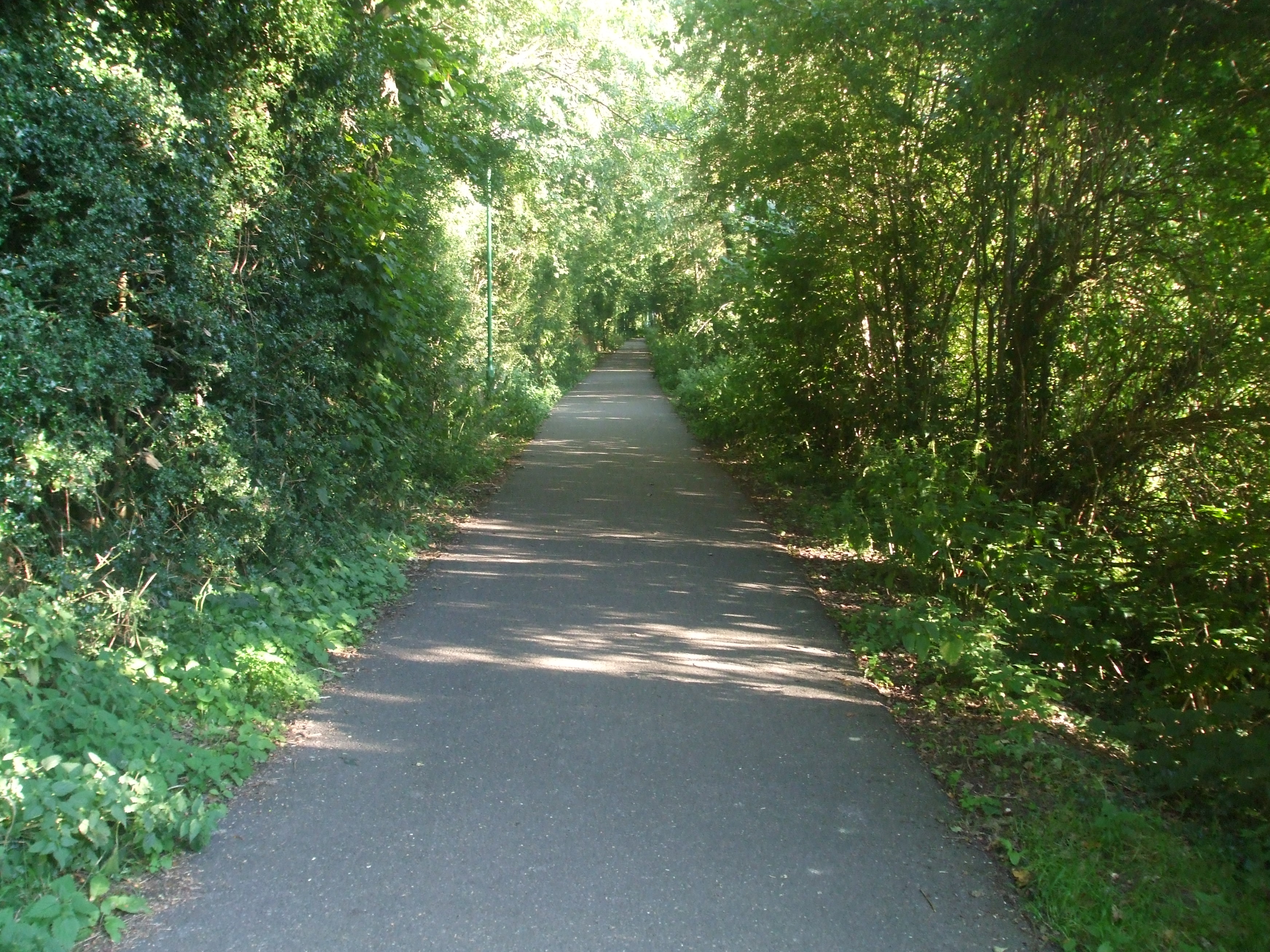
Lancefield Wood offers a range of walking trails and paths, allowing visitors to explore its natural beauty at their own pace. The trails wind their way through the forest, offering glimpses of ancient trees, babbling brooks, and tranquil ponds. The wood is also home to a variety of wildlife, including deer, foxes, squirrels, and a plethora of bird species, making it a paradise for nature enthusiasts and birdwatchers.

In addition to its natural beauty, Lancefield Wood provides recreational facilities such as picnic areas and seating areas, making it an ideal spot for families and groups to enjoy a day out in nature. The peaceful atmosphere and stunning scenery make it a perfect retreat from the hustle and bustle of everyday life.

Overall, Lancefield Wood in Kent is a charming and captivating forest that offers visitors a chance to connect with nature and experience the tranquility of the British countryside.

If you have any feedback on the listing, please let us know in the comments section below.

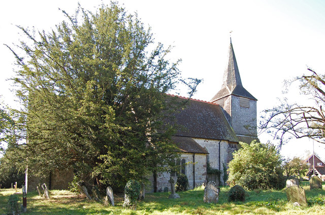
Lancefield Wood Images

Images are sourced within 2km of 51.091052/0.71372283 or Grid Reference TQ9035. Thanks to Geograph Open Source API. All images are credited.

Bluebells at Great Piper Wood Still going strong, a woodland awash with bluebells by footpath between Ingleden and Brissenden.

<a href="https://www.geograph.org.uk/photo/2393230">TQ9034 : Bluebells at Great Piper Wood</a>
Bluebells at Great Piper Wood
Still going strong, a woodland awash with bluebells by footpath between Ingleden and Brissenden. TQ9034 : Bluebells at Great Piper Wood
Bluebells at Great Piper Wood Still going strong, a woodland awash with bluebells by footpath between Ingleden and Brissenden.
Bluebells at Great Piper Wood
Still going strong, a woodland awash with bluebells by footpath between Ingleden and Brissenden.
Bluebells at Great Piper Wood Still going strong, a woodland awash with bluebells by footpath between Ingleden and Brissenden.
Bluebells at Great Piper Wood
Still going strong, a woodland awash with bluebells by footpath between Ingleden and Brissenden.
Brissenden Farmhouse A C15 grade II  listed Wealden Hall House. The western end has been replaced in c18, and a modern extension is seen here to the rear of the house.
Brissenden Farmhouse
A C15 grade II listed Wealden Hall House. The western end has been replaced in c18, and a modern extension is seen here to the rear of the house.
Oast House at Huntbourne Farm, Swain Road, St Michaels -
Oast House at Huntbourne Farm, Swain Road, St Michaels
-
Pond at Brissenden From footbridge over a stream from the pond. On footpath between Brissenden, Ingleden and the B2067.
Pond at Brissenden
From footbridge over a stream from the pond. On footpath between Brissenden, Ingleden and the B2067.
Dead woodland Dead trees in Stonehouse Wood, on footpath from Swain Road, past Ingleden.
Dead woodland
Dead trees in Stonehouse Wood, on footpath from Swain Road, past Ingleden.
Style near Ingleden On footpath from Tenterden to Swain Road.
Style near Ingleden
On footpath from Tenterden to Swain Road.
Footpath junction near Ingleden The crossing of footpaths AB11 between St Michaels and Brissenden. and AB13 between Knockwood Road and Swain Road.
Footpath junction near Ingleden
The crossing of footpaths AB11 between St Michaels and Brissenden. and AB13 between Knockwood Road and Swain Road.
House and garage at Brissenden The house to the right lies in the grounds of <a href="https://www.geograph.org.uk/photo/2393266">TQ9034 : Brissenden Farmhouse</a> and stands on the site of a former round kiln oast house.
House and garage at Brissenden
The house to the right lies in the grounds of TQ9034 : Brissenden Farmhouse and stands on the site of a former round kiln oast house.
Tenterden, Woodchurch Road Tenterden, Woodchurch Road (B2067).
Tenterden, Woodchurch Road
Tenterden, Woodchurch Road (B2067).
Oilseed Rape fields near High Halden Rapeseed (Brassica napus), also known as rape, oilseed rape and canola, is a bright yellow flowering member of the family Brassicaceae (mustard or cabbage family).
Rapeseed is grown for the production of animal feed, vegetable oil for human consumption, and increasingly biodiesel; leading producers include the European Union, Canada, the United States, Australia, China and India.
Oilseed Rape fields near High Halden
Rapeseed (Brassica napus), also known as rape, oilseed rape and canola, is a bright yellow flowering member of the family Brassicaceae (mustard or cabbage family). Rapeseed is grown for the production of animal feed, vegetable oil for human consumption, and increasingly biodiesel; leading producers include the European Union, Canada, the United States, Australia, China and India.
The Chequers Inn, High Halden, Kent
Harbourne Lane
Harbourne Lane
St Mary the Virgin church, High Halden Grade I listed.
The church consists of nave, chancel, south aisle and South chapel from the 15th century, and north chapel which now houses the organ. There is a wooden western tower, circa 1300, with scissor trusses, shingled outside with a shingle spire above. The ground floor of the tower is octagon shaped with entrance lobby, vestry to the north and tower stairs to the south. The nave is Norman and the chancel is 14th century as is the south porch and crown post roof to nave and aisle.
The font is early 13th century with the square bowl of Kentish rag.
The chancel arch was rebuilt early in the 14th century when the old one was collapsing. There is a squint from the north chapel and also one from south chapel.
The south aisle has a three bay arcade of perpendicular style with Bethersden marble bases used as seats originally. They are of a high standard and similar to some in Canterbury Cathedral.
In the 1990s the chancel floor showed signs of subsidence this was caused by vaults beneath the chancel floor, the faults were filled in but further subsidence has occurred since then. The church is awaiting funding for repairs.
There are six bells, the oldest from the early 17th century. There are several windows dating from the 13th to the 15th century.
The churchyard contains oven tombs similar to those at St Margaret's Church Bethersden. see <a href="https://www.geograph.org.uk/photo/2943869">TQ9240 : Oven Vaults, St Margaret's church, Bethersden</a>
St Mary the Virgin church, High Halden
Grade I listed. The church consists of nave, chancel, south aisle and South chapel from the 15th century, and north chapel which now houses the organ. There is a wooden western tower, circa 1300, with scissor trusses, shingled outside with a shingle spire above. The ground floor of the tower is octagon shaped with entrance lobby, vestry to the north and tower stairs to the south. The nave is Norman and the chancel is 14th century as is the south porch and crown post roof to nave and aisle. The font is early 13th century with the square bowl of Kentish rag. The chancel arch was rebuilt early in the 14th century when the old one was collapsing. There is a squint from the north chapel and also one from south chapel. The south aisle has a three bay arcade of perpendicular style with Bethersden marble bases used as seats originally. They are of a high standard and similar to some in Canterbury Cathedral. In the 1990s the chancel floor showed signs of subsidence this was caused by vaults beneath the chancel floor, the faults were filled in but further subsidence has occurred since then. The church is awaiting funding for repairs. There are six bells, the oldest from the early 17th century. There are several windows dating from the 13th to the 15th century. The churchyard contains oven tombs similar to those at St Margaret's Church Bethersden. see TQ9240 : Oven Vaults, St Margaret's church, Bethersden
St Mary the Virgin church, High Halden View from North West
St Mary the Virgin church, High Halden
View from North West
Oven Tomb, St Mary's church, High Halden Grade I listed.
The church consists of nave, chancel, south aisle and South chapel from the 15th century, and north chapel which now houses the organ. There is a wooden western tower, circa 1300, with scissor trusses, shingled outside with a shingle spire above. The ground floor of the tower is octagon shaped with entrance lobby, vestry to the north and tower stairs to the south. The nave is Norman and the chancel is 14th century as is the south porch and crown post roof to nave and aisle.
The font is early 13th century with the square bowl of Kentish rag.
The chancel arch was rebuilt early in the 14th century when the old one was collapsing. There is a squint from the north chapel and also one from south chapel.
The south aisle has a three bay arcade of perpendicular style with Bethersden marble bases used as seats originally. They are of a high standard and similar to some in Canterbury Cathedral.
In the 1990s the chancel floor showed signs of subsidence this was caused by vaults beneath the chancel floor, the faults were filled in but further subsidence has occurred since then. The church is awaiting funding for repairs.
There are six bells, the oldest from the early 17th century. There are several windows dating from the 13th to the 15th century.
The churchyard contains oven tombs similar to those at St Margaret's Church Bethersden. see <a href="https://www.geograph.org.uk/photo/2943869">TQ9240 : Oven Vaults, St Margaret's church, Bethersden</a>
Oven Tomb, St Mary's church, High Halden
Grade I listed. The church consists of nave, chancel, south aisle and South chapel from the 15th century, and north chapel which now houses the organ. There is a wooden western tower, circa 1300, with scissor trusses, shingled outside with a shingle spire above. The ground floor of the tower is octagon shaped with entrance lobby, vestry to the north and tower stairs to the south. The nave is Norman and the chancel is 14th century as is the south porch and crown post roof to nave and aisle. The font is early 13th century with the square bowl of Kentish rag. The chancel arch was rebuilt early in the 14th century when the old one was collapsing. There is a squint from the north chapel and also one from south chapel. The south aisle has a three bay arcade of perpendicular style with Bethersden marble bases used as seats originally. They are of a high standard and similar to some in Canterbury Cathedral. In the 1990s the chancel floor showed signs of subsidence this was caused by vaults beneath the chancel floor, the faults were filled in but further subsidence has occurred since then. The church is awaiting funding for repairs. There are six bells, the oldest from the early 17th century. There are several windows dating from the 13th to the 15th century. The churchyard contains oven tombs similar to those at St Margaret's Church Bethersden. see TQ9240 : Oven Vaults, St Margaret's church, Bethersden
Tower, St Mary's church, High Halden Grade I listed.
The church consists of nave, chancel, south aisle and South chapel from the 15th century, and north chapel which now houses the organ. There is a wooden western tower, circa 1300, with scissor trusses, shingled outside with a shingle spire above. The ground floor of the tower is octagon shaped with entrance lobby, vestry to the north and tower stairs to the south. The nave is Norman and the chancel is 14th century as is the south porch and crown post roof to nave and aisle.
The font is early 13th century with the square bowl of Kentish rag.
The chancel arch was rebuilt early in the 14th century when the old one was collapsing. There is a squint from the north chapel and also one from south chapel.
The south aisle has a three bay arcade of perpendicular style with Bethersden marble bases used as seats originally. They are of a high standard and similar to some in Canterbury Cathedral.
In the 1990s the chancel floor showed signs of subsidence this was caused by vaults beneath the chancel floor, the faults were filled in but further subsidence has occurred since then. The church is awaiting funding for repairs.
There are six bells, the oldest from the early 17th century. There are several windows dating from the 13th to the 15th century.
The churchyard contains oven tombs similar to those at St Margaret's Church Bethersden. see <a href="https://www.geograph.org.uk/photo/2943869">TQ9240 : Oven Vaults, St Margaret's church, Bethersden</a>
Tower, St Mary's church, High Halden
Grade I listed. The church consists of nave, chancel, south aisle and South chapel from the 15th century, and north chapel which now houses the organ. There is a wooden western tower, circa 1300, with scissor trusses, shingled outside with a shingle spire above. The ground floor of the tower is octagon shaped with entrance lobby, vestry to the north and tower stairs to the south. The nave is Norman and the chancel is 14th century as is the south porch and crown post roof to nave and aisle. The font is early 13th century with the square bowl of Kentish rag. The chancel arch was rebuilt early in the 14th century when the old one was collapsing. There is a squint from the north chapel and also one from south chapel. The south aisle has a three bay arcade of perpendicular style with Bethersden marble bases used as seats originally. They are of a high standard and similar to some in Canterbury Cathedral. In the 1990s the chancel floor showed signs of subsidence this was caused by vaults beneath the chancel floor, the faults were filled in but further subsidence has occurred since then. The church is awaiting funding for repairs. There are six bells, the oldest from the early 17th century. There are several windows dating from the 13th to the 15th century. The churchyard contains oven tombs similar to those at St Margaret's Church Bethersden. see TQ9240 : Oven Vaults, St Margaret's church, Bethersden
Show me another place!

Lancefield Wood is located at Grid Ref: TQ9035 (Lat: 51.091052, Lng: 0.71372283)

Administrative County: Kent

District: Ashford

Police Authority: Kent

What 3 Words

///knowledge.choice.samples. Near High Halden, Kent

Related Wikis

High Halden

High Halden is a village and civil parish in the Ashford District of Kent, England. The village is on the A28 road between Ashford and Tenterden, 3 miles...

St Michaels, Kent

St Michaels is a village in the civil parish of Tenterden, in the Ashford district, in the county of Kent, England. Before 1863 it was known as Boar's...

Tenterden St Michael's railway station

Tenterden St. Michael's was a railway station on the Kent and East Sussex Railway which served the Tenterden suburb of St Michaels in Kent, England. The...

Homewood School

Homewood School and Sixth Form Centre is an academy school in Tenterden, Kent, England. Homewood is a non-selective school, but is situated within the...

Nearby Amenities

Located within 500m of 51.091052,0.71372283
The data included in this document is from www.openstreetmap.org. The data is made available under ODbL.

Have you been to Lancefield Wood?

Leave your review of Lancefield Wood below (or comments, questions and feedback).