Long Shaw

Wood, Forest in Sussex Hastings

England

Long Shaw

Cliffs at Ecclesbourne Glen A view from the Saxon Shore Way
Cliffs at Ecclesbourne Glen Credit: Des Blenkinsopp

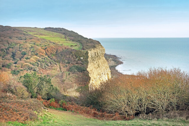
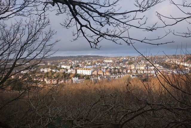
Long Shaw is a picturesque woodland located in Sussex, England. Situated in the heart of the countryside, it offers visitors a serene and tranquil escape from the hustle and bustle of everyday life. The forest is part of the wider Ashdown Forest, which is known for its natural beauty and diverse ecosystem.

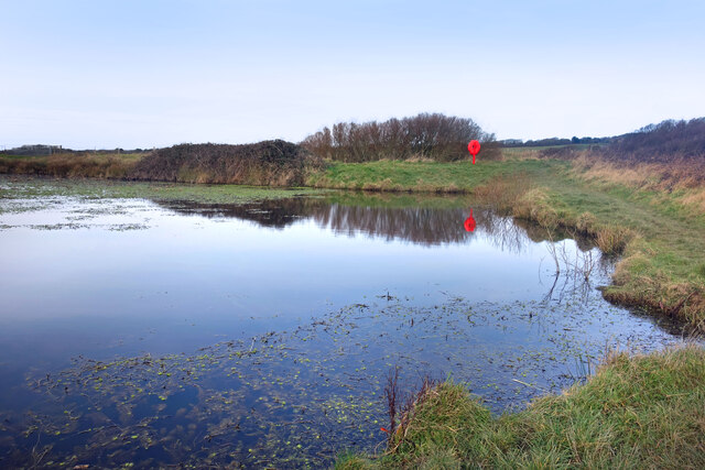
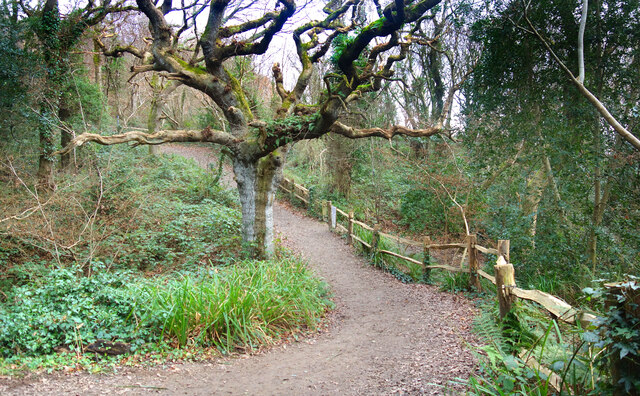
Covering an area of approximately 300 hectares, Long Shaw is characterized by its dense canopy of towering oak, beech, and holly trees. The forest floor is adorned with a rich carpet of ferns, bluebells, and other wildflowers, creating a stunning display of colors throughout the seasons.

The woodland is home to a variety of wildlife, including deer, badgers, and a plethora of bird species. Nature enthusiasts and birdwatchers will find plenty to admire, as the forest provides a sanctuary for many rare and endangered birds.

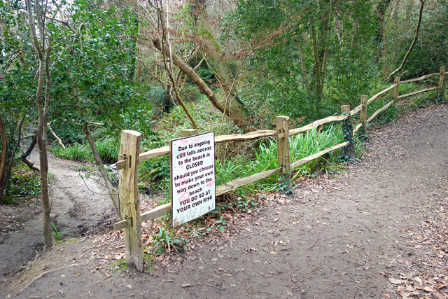
Long Shaw offers an extensive network of walking trails, allowing visitors to explore the forest at their own pace. These paths wind their way through the ancient woodland, revealing hidden glades, babbling brooks, and breathtaking views of the surrounding countryside.

For those seeking a more immersive experience, camping facilities are available within designated areas of the forest. This provides an opportunity to truly connect with nature and experience the magic of the woodland after sunset.

Long Shaw is a true gem for nature lovers, offering a peaceful retreat where visitors can reconnect with the natural world. Whether it's a leisurely stroll, a birdwatching adventure, or a camping trip, this woodland has something to offer for everyone.

If you have any feedback on the listing, please let us know in the comments section below.

Long Shaw Images

Images are sourced within 2km of 50.866769/0.62726133 or Grid Reference TQ8410. Thanks to Geograph Open Source API. All images are credited.

Cliffs at Ecclesbourne Glen A view from the Saxon Shore Way
Cliffs at Ecclesbourne Glen
A view from the Saxon Shore Way
Coastal view at Hastings Country Park Nature Reserve Hastings Country Park Nature Reserve consists of 853 acres of ancient woodland, heathland, grassland and farmland together with three miles of sandstone cliffs and coastline.

This view from near the Visitor Centre looks along the coast at Pett Level towards Winchelsea Beach and Romney Marsh. The coastline curves away towards Dungeness on the right.
Coastal view at Hastings Country Park Nature Reserve
Hastings Country Park Nature Reserve consists of 853 acres of ancient woodland, heathland, grassland and farmland together with three miles of sandstone cliffs and coastline. This view from near the Visitor Centre looks along the coast at Pett Level towards Winchelsea Beach and Romney Marsh. The coastline curves away towards Dungeness on the right.
Hastings Country Park A view looking south east over the eastern section of the 345 hectares of coast, cliffs, woodland, valleys and grassland which has been a country park since 1974.
<span class="nowrap"><a title="https://www.hastings.gov.uk/countryside-nature/naturereserves/naturereserves-hastings/hcp/" rel="nofollow ugc noopener" href="https://www.hastings.gov.uk/countryside-nature/naturereserves/naturereserves-hastings/hcp/">Link</a><img style="margin-left:2px;" alt="External link" title="External link - shift click to open in new window" src="https://s1.geograph.org.uk/img/external.png" width="10" height="10"/></span>
Hastings Country Park
A view looking south east over the eastern section of the 345 hectares of coast, cliffs, woodland, valleys and grassland which has been a country park since 1974. LinkExternal link
Sandstone in an Old Quarry A disused sand quarry in Hastings Country Park.
In production until the 1960s, the quarry produced a fine grained white sand which was used in high quality glass making.
Several sandstone outcrops are still to be seen among the largely overgrown former workings.
Sandstone in an Old Quarry
A disused sand quarry in Hastings Country Park. In production until the 1960s, the quarry produced a fine grained white sand which was used in high quality glass making. Several sandstone outcrops are still to be seen among the largely overgrown former workings.
In an Old Quarry A former sand quarry which ceased production in the 1960s has now been mostly reclaimed by tees and gorse. A few outcrops of sandstone can still be seen in places.
Now part of Hastings Country Park.
In an Old Quarry
A former sand quarry which ceased production in the 1960s has now been mostly reclaimed by tees and gorse. A few outcrops of sandstone can still be seen in places. Now part of Hastings Country Park.
Signpost in the Country Park Hastings Country Park was set up in 1974. <span class="nowrap"><a title="https://www.hastings.gov.uk/parks_gardens_allotments/parks/hastings-country/" rel="nofollow ugc noopener" href="https://www.hastings.gov.uk/parks_gardens_allotments/parks/hastings-country/">Link</a><img style="margin-left:2px;" alt="External link" title="External link - shift click to open in new window" src="https://s1.geograph.org.uk/img/external.png" width="10" height="10"/></span>
A series of mostly easy going trails with a few steep bits have been laid out through the park's 345 hectares.
Signpost in the Country Park
Hastings Country Park was set up in 1974. LinkExternal link A series of mostly easy going trails with a few steep bits have been laid out through the park's 345 hectares.
The Dripping Well Not exactly a well, more of a rather atmospheric sort of mossy grotto where water drips over an outcrop of sandstone.
The Dripping Well
Not exactly a well, more of a rather atmospheric sort of mossy grotto where water drips over an outcrop of sandstone.
Footpath Closed, Fairlight Glen Rock falls along the cliffs have led to the path down to the coast being officially closed, although it looks like a lot of people ignore this notice and carry on anyway.
Footpath Closed, Fairlight Glen
Rock falls along the cliffs have led to the path down to the coast being officially closed, although it looks like a lot of people ignore this notice and carry on anyway.
Barn Pond A small pond in the fields. This is a winter picture showing mostly open water.
Other images here show it can be dried up or full of weeds.
Barn Pond
A small pond in the fields. This is a winter picture showing mostly open water. Other images here show it can be dried up or full of weeds.
The Bale House A new visitor centre and cafe in Hastings Country Park.
Straw bales have been used in its construction. <span class="nowrap"><a title="https://www.hastings.gov.uk/parks_gardens_allotments/parks/visitorcentre/about/" rel="nofollow ugc noopener" href="https://www.hastings.gov.uk/parks_gardens_allotments/parks/visitorcentre/about/">Link</a><img style="margin-left:2px;" alt="External link" title="External link - shift click to open in new window" src="https://s1.geograph.org.uk/img/external.png" width="10" height="10"/></span>
The Bale House
A new visitor centre and cafe in Hastings Country Park. Straw bales have been used in its construction. LinkExternal link
Cycle Route 2 along Barley Lane A nice easy section of National Cycle Route 2 which starts in Dover and heads westwards along the south coast. One of the trademark decorative metal signposts is on the verge.
Cycle Route 2 along Barley Lane
A nice easy section of National Cycle Route 2 which starts in Dover and heads westwards along the south coast. One of the trademark decorative metal signposts is on the verge.
A Corner on the Route The 1066 Country Route and National Cycle Route 2 head off to the left, while an ordinary footpath carries on ahead to the Hastings Country Park visitor centre.
A Corner on the Route
The 1066 Country Route and National Cycle Route 2 head off to the left, while an ordinary footpath carries on ahead to the Hastings Country Park visitor centre.
Woodland Trail, Fairlight Glen The path follows the valley of the small stream which runs down to the sea from The Dripping Well.
Woodland Trail, Fairlight Glen
The path follows the valley of the small stream which runs down to the sea from The Dripping Well.
Almost the Saxon Shore Way On open common like this there are tracks all over the place.
This one isn't the waymarked Saxon Shore Way, but it's going in the same direction and only a short distance away. 
Taken on a dismal wet afternoon when the world looks better in black & white.
Almost the Saxon Shore Way
On open common like this there are tracks all over the place. This one isn't the waymarked Saxon Shore Way, but it's going in the same direction and only a short distance away. Taken on a dismal wet afternoon when the world looks better in black & white.
View from Rocklands Lane Unsettled weather moving in over the town. 
Rocklands Lane is a small road coming down from the open land on top of East Hill. It's part of the 1066 Country Walk.
View from Rocklands Lane
Unsettled weather moving in over the town. Rocklands Lane is a small road coming down from the open land on top of East Hill. It's part of the 1066 Country Walk.
Country Walk in the Country Park A lovely afternoon is taking a turn for the worse as grey clouds move in over Hastings Country Park. The track is part of the 1066 Country Walk.
Country Walk in the Country Park
A lovely afternoon is taking a turn for the worse as grey clouds move in over Hastings Country Park. The track is part of the 1066 Country Walk.
Show me another place!

Long Shaw is located at Grid Ref: TQ8410 (Lat: 50.866769, Lng: 0.62726133)

Administrative County: East Sussex

District: Hastings

Police Authority: Sussex

What 3 Words

///half.zoos.offshore. Near Fairlight, East Sussex

Related Wikis

Hastings Country Park

Hastings Country Park was formed in 1974 and covers 345 hectares (850 acres) east of Hastings in England. Sandstone cliffs, glens covered with gorse and...

Fairlight Glen

Fairlight Glen lies about 2 miles (3.2 km) east of the fishing port of Hastings and 1.5 miles (2.4 km) west of the small village of Fairlight Cove on the...

All Souls Church, Hastings

All Souls Church is a former Anglican church that served the Clive Vale suburb of Hastings, a seaside resort town and borough in the English county of...

Ore, East Sussex

Ore is a large suburb of the urban area of Hastings, in the Hastings district, in the county of East Sussex, England. Formerly a village, it is still known...

Nearby Amenities

Located within 500m of 50.866769,0.62726133
Source: PGS
Lat/Long: 50.8625664/0.6285072
Source: PGS
Lat/Long: 50.8632788/0.6298257
Source: PGS
Lat/Long: 50.8638009/0.6303364
Source: PGS
Lat/Long: 50.8645817/0.630963
Source: PGS
Lat/Long: 50.8651302/0.6314351
Dripping Well
Natural: spring
Lat/Long: 50.8696203/0.6284522
Information: map
Tourism: information
Lat/Long: 50.8690116/0.6275405
13
Information: guidepost
Operator: Hastings Country Park
Tourism: information
Lat/Long: 50.8689627/0.6251078
10
Information: guidepost
Operator: Hastings Country Park
Tourism: information
Lat/Long: 50.8654465/0.6233207
9
Information: guidepost
Operator: Hastings Country Park
Tourism: information
Lat/Long: 50.8667725/0.6202698
12
Information: guidepost
Operator: Hastings Country Park
Tourism: information
Lat/Long: 50.8645505/0.6251326
14
Information: guidepost
Operator: Hastings Country Park
Tourism: information
Lat/Long: 50.8650431/0.6281924
15
Information: guidepost
Operator: Hastings Country Park
Tourism: information
Lat/Long: 50.8690424/0.6275242
16
Information: guidepost
Operator: Hastings Country Park
Tourism: information
Lat/Long: 50.8660126/0.6299081
17
Information: guidepost
Operator: Hastings Country Park
Tourism: information
Lat/Long: 50.868298/0.6316234
Fairlight Glen
Place: locality
Lat/Long: 50.8660933/0.6291157
Bench
Backrest: yes
Lat/Long: 50.864602/0.6259761
Bench
Backrest: no
Lat/Long: 50.8646391/0.625049
Fairlight Glen Naturist Beach
Natural: beach
Nudism: yes
Surface: pebblestone
Lat/Long: 50.8652127/0.631661
The data included in this document is from www.openstreetmap.org. The data is made available under ODbL.

Have you been to Long Shaw?

Leave your review of Long Shaw below (or comments, questions and feedback).