Blounts Wood

Wood, Forest in Essex Rochford

England

Blounts Wood

Arable field off Lower Road, Hullbridge
Arable field off Lower Road, Hullbridge Credit: Roger Jones

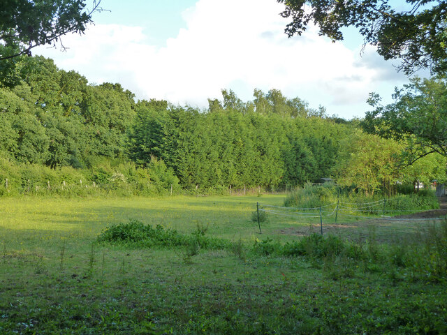
Blounts Wood is a picturesque woodland area located in the county of Essex, England. Situated near the village of Blounts End, it covers an area of approximately 100 acres and is known for its natural beauty and diverse ecosystem.

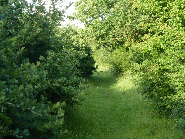
The wood is predominantly composed of broadleaf trees, including oak, beech, and ash, which create a dense and lush canopy overhead. Beneath the towering trees, the forest floor is carpeted with a variety of flora, such as bluebells, wild garlic, and wood sorrel, adding bursts of color and fragrance to the woodland.

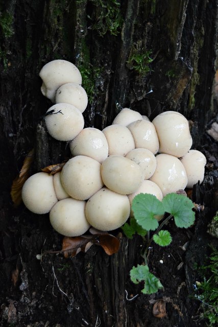
Blounts Wood is home to a wide range of wildlife, making it a popular destination for nature enthusiasts. Visitors may spot red squirrels, badgers, and numerous bird species, including woodpeckers, tits, and thrushes. The tranquil setting also attracts a variety of insects, such as butterflies and dragonflies, which thrive in the wood's diverse habitat.

The wood is crisscrossed by a network of well-maintained footpaths, allowing visitors to explore its beauty at their own pace. These trails wind through the ancient woodland, offering picturesque views of the surrounding countryside and providing opportunities for peaceful walks, picnics, and birdwatching.

Blounts Wood is managed by a local conservation organization, which ensures the preservation of its natural habitat and biodiversity. The wood also serves as an educational resource, with guided tours and nature programs organized for schools and other groups.

Overall, Blounts Wood offers a tranquil escape from the hustle and bustle of everyday life, providing a haven for both wildlife and visitors seeking to immerse themselves in the beauty of nature.

If you have any feedback on the listing, please let us know in the comments section below.

Blounts Wood Images

Images are sourced within 2km of 51.604581/0.62460074 or Grid Reference TQ8192. Thanks to Geograph Open Source API. All images are credited.

Arable field off Lower Road, Hullbridge
Open land near Victoria Road, Rayleigh <span class="nowrap"><a title="https://en.wikipedia.org/wiki/Rayleigh,_Essex" rel="nofollow ugc noopener" href="https://en.wikipedia.org/wiki/Rayleigh,_Essex">Link</a><img style="margin-left:2px;" alt="External link" title="External link - shift click to open in new window" src="https://s1.geograph.org.uk/img/external.png" width="10" height="10"/></span>
Open land near Victoria Road, Rayleigh
Sweyne Park Open Space, Rayleigh Sweyne Park Open Space is managed by Rochford District Council: <span class="nowrap"><a title="https://www.rochford.gov.uk/leisure-and-tourism/woodlands-parks-and-open-spaces/sweyne-park-open-space" rel="nofollow ugc noopener" href="https://www.rochford.gov.uk/leisure-and-tourism/woodlands-parks-and-open-spaces/sweyne-park-open-space">Link</a><img style="margin-left:2px;" alt="External link" title="External link - shift click to open in new window" src="https://s1.geograph.org.uk/img/external.png" width="10" height="10"/></span>
They say:
"The area currently known as Sweyne Park Open Space was originally war time agricultural land, after which it continued in agricultural tenancy until transferred from the Ministry of Agriculture to Rochford District Council in the late 1980's...

The park is approximately 57 acres in size, with 2 kilometres of pathways and 4 Kilometres of hedging"
Sweyne Park Open Space, Rayleigh
Sweyne Park Open Space is managed by Rochford District Council: LinkExternal link They say: "The area currently known as Sweyne Park Open Space was originally war time agricultural land, after which it continued in agricultural tenancy until transferred from the Ministry of Agriculture to Rochford District Council in the late 1980's... The park is approximately 57 acres in size, with 2 kilometres of pathways and 4 Kilometres of hedging"
Paddocks near Goldsmith Drive, Rayleigh The light fencing here suggests use for horses in this semi-rural bit of land seen from a bridleway.
Paddocks near Goldsmith Drive, Rayleigh
The light fencing here suggests use for horses in this semi-rural bit of land seen from a bridleway.
Fence and hedge New "wildlife strip" bordering Bull Wood along the public footpath
Fence and hedge
New "wildlife strip" bordering Bull Wood along the public footpath
Hullbridge Road, Rayleigh A residential service road parallel with the main Hullbridge Road on the left, looking here, for the visible part, like the original course of the through route.
Hullbridge Road, Rayleigh
A residential service road parallel with the main Hullbridge Road on the left, looking here, for the visible part, like the original course of the through route.
Entrance to Ferndale Open Space With a child care establishment.
Entrance to Ferndale Open Space
With a child care establishment.
Back of houses on Ferndale Road Viewed from  Ferndale Open Space.
Back of houses on Ferndale Road
Viewed from Ferndale Open Space.
Child care premises, Ferndale Open Space
Bunker, Lords Golf and Country Club
Path towards golf course Not a public route.
Path towards golf course
Not a public route.
Field behind house on Ferndale Road A sort of extended back garden, apparently grazing for something.
Field behind house on Ferndale Road
A sort of extended back garden, apparently grazing for something.
Track to Ferndale Open Space
Trompettes de la Morte Craterellus cornucopioides (aka Horn of Plenty, Black Chanterelle)  I came upon a large patch of these fungi freshly sprung from the forest floor in Hockley Woods. And very tasty they were too, despite the French name, Trumpet of Death!
Trompettes de la Morte
Craterellus cornucopioides (aka Horn of Plenty, Black Chanterelle) I came upon a large patch of these fungi freshly sprung from the forest floor in Hockley Woods. And very tasty they were too, despite the French name, Trumpet of Death!
Stump Puffballs Lycoperdon pyriforme (aka Pear-shaped Puffball). Young specimens on oak stump, Hockley Woods
Stump Puffballs
Lycoperdon pyriforme (aka Pear-shaped Puffball). Young specimens on oak stump, Hockley Woods
Lubards Farm Industrial Estate Off Hullbridge Road
<span class="nowrap"><a title="http://www.petsinpartnership.co.uk/" rel="nofollow ugc noopener" href="http://www.petsinpartnership.co.uk/">Link</a><img style="margin-left:2px;" alt="External link" title="External link - shift click to open in new window" src="https://s1.geograph.org.uk/img/external.png" width="10" height="10"/></span>
Lubards Farm Industrial Estate
Off Hullbridge Road LinkExternal link
Pets in Partnership sign Off Hullbridge Road at the entrance to Lubards Farm Industrial Estate
<span class="nowrap"><a title="http://www.petsinpartnership.co.uk/" rel="nofollow ugc noopener" href="http://www.petsinpartnership.co.uk/">Link</a><img style="margin-left:2px;" alt="External link" title="External link - shift click to open in new window" src="https://s1.geograph.org.uk/img/external.png" width="10" height="10"/></span>
Pets in Partnership sign
Off Hullbridge Road at the entrance to Lubards Farm Industrial Estate LinkExternal link
Show me another place!

Blounts Wood is located at Grid Ref: TQ8192 (Lat: 51.604581, Lng: 0.62460074)

Administrative County: Essex

District: Rochford

Police Authority: Essex

What 3 Words

///gone.abode.shady. Near Rayleigh, Essex

Nearby Locations

Blounts Wood

Related Wikis

Hockley

Hockley is a large village and civil parish in Essex in the East of England located between Chelmsford and Southend-on-Sea, or, more specifically, between...

Hullbridge Sports F.C.

Hullbridge Sports Football Club is a football club based in Hullbridge, Essex, England. They are currently members of the Essex Senior League and play...

HM Prison Bullwood Hall

HM Prison Bullwood Hall is a former Category C women's prison and Young Offenders Institution, located in Hockley, Essex, England. The prison was operated...

Hockley Woods

Hockley Woods is a large woodland in south-east Essex. It is a Local Nature Reserve, and parts are a Site of Special Scientific Interest. It is owned and...

Brandy Hole

Brandy Hole is the name of a large area of saltmarsh and saltings on the River Crouch in Rochford District in the County of Essex, England. It is located...

Hullbridge

Hullbridge is a village and civil parish in the Rochford district of Essex in England. Bordered to the north by the River Crouch, as well a distance from...

FitzWimarc School

FitzWimarc School is a secondary school in Rayleigh, United Kingdom, named after the Norman land-holder Robert FitzWimarc. == History == 1927 Opened as...

The Sweyne Park School

The Sweyne Park School is a coeducational secondary school situated in Rayleigh, Essex, England, with specialised provision for hearing-impaired pupils...

Nearby Amenities

Located within 500m of 51.604581,0.62460074
Crossing
Railway: crossing
Lat/Long: 51.6057179/0.6296533
Crossing
Railway: crossing
Lat/Long: 51.6057362/0.6296417
Railway: crossing
Lat/Long: 51.603784/0.6233936
The data included in this document is from www.openstreetmap.org. The data is made available under ODbL.

Have you been to Blounts Wood?

Leave your review of Blounts Wood below (or comments, questions and feedback).