Foxburrow Wood

Wood, Forest in Kent

England

Foxburrow Wood

Spade Lane, near Hartlip
Spade Lane, near Hartlip Credit: Chris Whippet

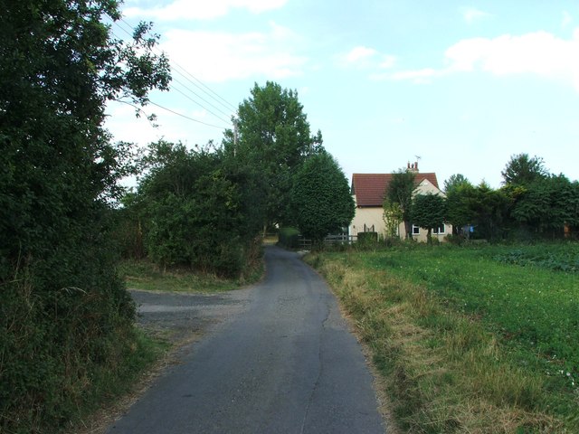
Foxburrow Wood is a picturesque woodland located in the county of Kent, England. Spanning over 100 acres, it is a natural haven for wildlife and a popular destination for nature enthusiasts. The wood is situated near the village of Foxburrow, and its tranquil atmosphere offers a peaceful retreat from the hustle and bustle of daily life.

The woodland is predominantly made up of broadleaf trees, with oak, beech, and ash being the most common species. The trees form a dense canopy, providing shade and shelter to a diverse range of flora and fauna. Bluebells carpet the forest floor in spring, creating a stunning display of color, while ferns and mosses add to the enchanting ambiance.

Foxburrow Wood is not only visually captivating, but it also serves as an important habitat for numerous wildlife species. Visitors may spot deer, badgers, and an array of bird species, including woodpeckers, owls, and warblers. The wood is also home to various insects, such as butterflies and dragonflies.

The woodland offers several walking trails that wind through its enchanting pathways, allowing visitors to immerse themselves in the natural beauty of the area. Additionally, there are picnic areas and benches where visitors can relax and soak in the peaceful ambiance.

Managed by a local conservation organization, Foxburrow Wood is dedicated to preserving its ecological integrity and promoting environmental education. Regular events and workshops are organized to engage the local community and raise awareness about the importance of conservation.

Overall, Foxburrow Wood is a treasured natural gem in Kent, offering a serene escape into the heart of nature and providing a valuable habitat for wildlife.

If you have any feedback on the listing, please let us know in the comments section below.

Foxburrow Wood Images

Images are sourced within 2km of 51.349937/0.59956256 or Grid Reference TQ8164. Thanks to Geograph Open Source API. All images are credited.

Spade Lane, near Hartlip
Meresborough Lane, near Rainham
South Bush Lane, near Rainham
Meresborough Road, Meresborough
Parker Close, Park Wood
Barlow Close, Park Wood
Goldsmith Road, Park Wood
Sinclair Close, Park Wood
Cragie Walk, Park Wood
Style Close, Park Wood
Lyall Way, Park Wood
Collet Walk, Park Wood
Conrad Close, Park Wood
Culpepper Road, Park Wood
Crispe Close, Park Wood
Collings Walk, Park Wood
Howbury Walk, Park Wood
Hardinge Close, Park Wood
Show me another place!

Foxburrow Wood is located at Grid Ref: TQ8164 (Lat: 51.349937, Lng: 0.59956256)

Unitary Authority: Medway

Police Authority: Kent

What 3 Words

///sharper.reworked.positive. Near Rainham, Kent

Nearby Locations

Foxburrow Wood

Related Wikis

Foxburrow Wood

Foxburrow Wood is a 6.1-hectare (15-acre) Local Nature Reserve in Rainham in Kent. It is owned and managed by Medway Council.This is a remnant of a much...

Park Wood, Medway

Park Wood or Parkwood is a housing estate and district in Gillingham at the south-eastern corner of the Medway conurbation in Kent, England. It was built...

Wigmore, Kent

Wigmore is a village in the southeast of Medway in Kent, England. It lies opposite Hempstead to the east and Rainham to the north east. == History == The...

Levan Strice

Levan Strice is a 2.8-hectare (6.9-acre) Local Nature Reserve in Wigmore in Kent. It consists mostly of woodland with public access trails. It is owned...

Medway services

Medway is a service area on the M2 motorway south of Medway, near Junction 4 in Kent, southeast England. It is managed by Moto and was previously named...

Rainham, Kent

Rainham ( RAY-nəm) is a town in the unitary authority of Medway, in Kent, South East England. The town forms a conurbation with neighbouring towns Chatham...

The Howard School, Kent

The Howard School is a boys' secondary school in Rainham, Kent, England, with approximately 1,500 pupils. It offers a partially selective system and is...

Rainham School for Girls

Rainham School for Girls is an 11–18 girls, secondary school and sixth form with academy status in Rainham, Gillingham, Kent, England. It is next to the...

Nearby Amenities

Located within 500m of 51.349937,0.59956256
Crossing
Crossing: uncontrolled
Crossing Ref: zebra
Lat/Long: 51.3488715/0.5944838
Toilets
Lat/Long: 51.3484557/0.5956921
Leisure: playground
Lat/Long: 51.3471794/0.5955063
Leisure: playground
Lat/Long: 51.3473803/0.5962772
Clinic
Parkwood Health Centre
Lat/Long: 51.3482785/0.5954993
Old Phone: +44 1634 261193
Postal Code: ME8 9SR
Removed Amenity: telephone
Lat/Long: 51.3483767/0.5952864
Bench
Lat/Long: 51.3482875/0.5953092
Pharmacy
Dispensing: yes
Level: 0
Operator: Fenns Chemists
Wheelchair: yes
Lat/Long: 51.348476/0.595109
Co-op Food
Addr Housenumber: 22
Addr Postcode: ME8 9PN
Addr Street: Parkwood Green Shopping Centre
Brand: Co-op Food
Brand Wikidata: Q3277439
Fhrs Authority: Medway
Fhrs Id: 802085
Fhrs Inspectiondate: 2015-08-27
Fhrs Rating: 5
Operator: The Co-operative Group
Operator Wikidata: Q117202
Shop: convenience
Website: https://www.coop.co.uk/store-finder/ME8-9PN/22-parkwood-green
Lat/Long: 51.3482319/0.5945282
Post Box
Postal Code: ME8
Ref: ME8 385
Lat/Long: 51.3485536/0.5944986
Bicycle Parking
Capacity: 4
Lat/Long: 51.3485105/0.594571
Traffic Calming: cushion
Lat/Long: 51.3489273/0.5936877
Parkwood
Place: suburb
Lat/Long: 51.3468466/0.5972271
Mierscourt Farm
Landuse: farm
Note Retag: CS #48756035
Shop: farm
Lat/Long: 51.3508866/0.6035894
Bus Stop
Dolphin Drive
Bus: yes
Naptan AtcoCode: 249000000443
Naptan Bearing: E
Naptan CommonName: Dolphin Drive
Naptan Indicator: E-bound
Naptan Landmark: Deanwood Drive
Naptan NaptanCode: chagjaj
Naptan PlusbusZoneRef: MEDWAY
Naptan Street: Dolphin Drive
Naptan Verified: yes
Public Transport: platform
Source: naptan_import
Lat/Long: 51.3468192/0.599758
Post Box
Ref: ME8 418
Lat/Long: 51.352369/0.6008595
Turning Circle
Lat/Long: 51.3533389/0.6006482
Post Box
Ref: ME8 367
Lat/Long: 51.3521468/0.5967755
Speed Camera
Source: audio
Lat/Long: 51.3506713/0.5967742
Speed Camera
Source: audio
Lat/Long: 51.3505116/0.596455
Recycling
Lat/Long: 51.3484098/0.5967585
Social Club
Parkwood Community Association
Addr City: Gillingham
Addr Country: GB
Addr County: Kent
Addr Housename: Parkwood Community Centre
Addr Postcode: ME8 9PN
Addr Street: Parkwood Green Shopping Centre
Building: yes
Fhrs Authority: Medway
Fhrs Id: 1066510
Lat/Long: 51.3480309/0.5966969
Parkwood Youth Centre
Building: yes
Lat/Long: 51.3480228/0.5963964
Park Wood Christian Fellowship
Building: yes
Religion: christian
Lat/Long: 51.3480669/0.5956953
Veterinary
Ralph Chambers & associates
Lat/Long: 51.348594/0.5944323
Bus Stop
Ploughmans Way East
Bus: yes
Naptan AtcoCode: 249000000441
Naptan Bearing: S
Naptan CommonName: Ploughmans Way East
Naptan Indicator: opp
Naptan Landmark: Ploughmans Way
Naptan NaptanCode: chagjad
Naptan PlusbusZoneRef: MEDWAY
Naptan ShortCommonName: Ploughmans Way
Naptan Street: Miers Court Road
Naptan Verified: no
Public Transport: platform
Source: naptan_import
Lat/Long: 51.3524165/0.6042064
Bus Stop
Ploughmans Way East
Bus: yes
Naptan AtcoCode: 249000000442
Naptan Bearing: N
Naptan CommonName: Ploughmans Way East
Naptan Indicator: adj
Naptan Landmark: Ploughmans Way
Naptan NaptanCode: chagjag
Naptan PlusbusZoneRef: MEDWAY
Naptan ShortCommonName: Ploughmans Way
Naptan Street: Miers Court Road
Naptan Verified: no
Public Transport: platform
Source: naptan_import
Lat/Long: 51.3516783/0.6032534
Bus Stop
Maryland Court
Bus: yes
Naptan AtcoCode: 249000000444
Naptan Bearing: S
Naptan CommonName: Maryland Court
Naptan Indicator: adj
Naptan Landmark: Maryland Court
Naptan NaptanCode: chagjam
Naptan PlusbusZoneRef: MEDWAY
Naptan Street: Miers Court Road
Naptan Verified: yes
Public Transport: platform
Source: naptan_import
Lat/Long: 51.3476243/0.6020549
Bus Stop
Maryland Court
Bus: yes
Naptan AtcoCode: 249000000445
Naptan Bearing: N
Naptan CommonName: Maryland Court
Naptan Indicator: opp
Naptan Landmark: Maryland Court
Naptan NaptanCode: chagjap
Naptan PlusbusZoneRef: MEDWAY
Naptan Street: Miers Court Road
Naptan Verified: yes
Public Transport: platform
Source: audio;naptan_import
Lat/Long: 51.3469696/0.6018659
Bus Stop
Findlay Close
Bus: yes
Naptan AtcoCode: 249000000470
Naptan Bearing: NW
Naptan CommonName: Findlay Close
Naptan Indicator: opp
Naptan Landmark: Findlay Close
Naptan NaptanCode: chagjpd
Naptan PlusbusZoneRef: MEDWAY
Naptan Street: Deanwood Drive
Naptan Verified: no
Public Transport: platform
Source: naptan_import
Lat/Long: 51.3507545/0.5963723
Bus Stop
Findlay Road
Bus: yes
Naptan AtcoCode: 249000000471
Naptan Bearing: SE
Naptan CommonName: Findlay Road
Naptan Indicator: adj
Naptan Landmark: Findlay Road
Naptan NaptanCode: chagjpg
Naptan PlusbusZoneRef: MEDWAY
Naptan Street: Deanwood Drive
Naptan Verified: no
Public Transport: platform
Source: naptan_import
Lat/Long: 51.3507959/0.5965326
Bus Stop
The Cherry Orchard
Bus: yes
Naptan AtcoCode: 249000000472
Naptan Bearing: NW
Naptan CommonName: The Cherry Orchard
Naptan Indicator: adj
Naptan Landmark: The Cherry Orchard PH
Naptan NaptanCode: chagjpj
Naptan PlusbusZoneRef: MEDWAY
Naptan Street: Deanwood Drive
Naptan Verified: no
Public Transport: platform
Source: naptan_import
Lat/Long: 51.3477337/0.5979392
Bus Stop
The Cherry Orchard
Bus: yes
Naptan AtcoCode: 249000000473
Naptan Bearing: SE
Naptan CommonName: The Cherry Orchard
Naptan Indicator: opp
Naptan Landmark: The Cherry Orchard PH
Naptan NaptanCode: chagjpm
Naptan PlusbusZoneRef: MEDWAY
Naptan Street: Deanwood Drive
Naptan Verified: no
Public Transport: platform
Source: naptan_import
Lat/Long: 51.347215/0.598502
Bus Stop
Tanker Hill
Bus: yes
Naptan AtcoCode: 249000000476
Naptan Bearing: SW
Naptan CommonName: Tanker Hill
Naptan Indicator: opp
Naptan Landmark: Tanker Hill
Naptan NaptanCode: chagjta
Naptan PlusbusZoneRef: MEDWAY
Naptan Street: Lonsdale Drive
Naptan Verified: no
Public Transport: platform
Source: naptan_import
Lat/Long: 51.3525701/0.5976384
Bus Stop
Tanker Hill
Bus: yes
Naptan AtcoCode: 249000000477
Naptan Bearing: NE
Naptan CommonName: Tanker Hill
Naptan Indicator: adj
Naptan Landmark: Tanker Hill
Naptan NaptanCode: chagjtd
Naptan PlusbusZoneRef: MEDWAY
Naptan Street: Lonsdale Drive
Naptan Verified: no
Public Transport: platform
Source: naptan_import
Lat/Long: 51.352942/0.5979036
Barrier: bollard
Lat/Long: 51.3465827/0.5968024
Barrier: bollard
Lat/Long: 51.3464553/0.5981376
Turning Circle
Lat/Long: 51.3517969/0.6001076
Turning Circle
Lat/Long: 51.3506011/0.6019653
Turning Circle
Lat/Long: 51.3492518/0.6010569
Source: OS_Open_StreetView
Lat/Long: 51.351951/0.5981364
Mierscourt Farm Shop
Addr City: Gillingham
Addr Country: GB
Addr County: Kent
Addr Postcode: ME8 8PJ
Addr Street: Mierscourt Road
Designation: Farm Shop And Pet Emporium
Fhrs Id: 727961
Shop: convenience
Source Addr: FHRS Open Data
Lat/Long: 51.3511142/0.6032817
Barrier: kissing_gate
Lat/Long: 51.3504773/0.6019373
Barrier: cycle_barrier
Lat/Long: 51.3517782/0.598925
Barrier: kissing_gate
Lat/Long: 51.3495846/0.597336
Barrier: cycle_barrier
Lat/Long: 51.3509393/0.6008516
Traffic Calming: cushion
Lat/Long: 51.3487539/0.5962219
Traffic Calming: cushion
Lat/Long: 51.3487631/0.5970663
Traffic Calming: cushion
Lat/Long: 51.3488204/0.5952505
Traffic Calming: cushion
Lat/Long: 51.3488504/0.5930581
Morrisons Daily
Addr Housenumber: 19-21
Addr Postcode: ME8 9PW
Addr Street: Parkwood Green Shopping Centre
Brand: Morrisons Daily
Brand Wikidata: Q99752411
Shop: convenience
Website: https://my.morrisons.com/storefinder/60274/morrisons-daily-rainham-parkwood-green
Lat/Long: 51.3484929/0.5945313
Post Office
Deanswood Post Office
Addr Postcode: ME8 9PW
Branch: Deanswood
Brand: Post Office
Brand Wikidata: Q1783168
Check Date: 2020-02-20
Contact Website: https://www.postoffice.co.uk/branch-finder/1009419/deanswood
Operator: McColls
Ref Pol Id: 1255
Lat/Long: 51.3484882/0.5945668
Fast Food
Eastern Choice
Addr Housenumber: 36
Addr Postcode: ME8 9PN
Addr Street: Parkwood Green Shopping Centre
Cuisine: chinese
Fhrs Authority: Medway
Fhrs Id: 569721
Fhrs Inspectiondate: 2015-05-15
Fhrs Rating: 5
Level: 0
Takeaway: only
Lat/Long: 51.3482156/0.5950798
John's Carpets
Craft: carpet_layer
Lat/Long: 51.3483836/0.5948035
Childcare
Parkwood Christian Fellowship Pre-School
Addr Postcode: ME8 9PN
Addr Street: Parkwood Green Shopping Centre
Age Group: 2-4
Fhrs Authority: Medway
Fhrs Id: 716254
Fhrs Inspectiondate: 2016-09-29
Fhrs Rating: 5
Kindergarten: yes
Level: 0
Operator Type: religious
Lat/Long: 51.3479522/0.5957086
X Barbers
Female: no
Level: 0
Male: yes
Shop: hairdresser
Unisex: no
Lat/Long: 51.3484827/0.5948334
V.E.White Solicitors
Level: 0
Office: lawyer
Lat/Long: 51.3484486/0.5944083
Edens Florists
Level: 0
Shop: florist
Lat/Long: 51.3485104/0.5944137
Betfred
Brand: Betfred
Brand Wikidata: Q4897425
Level: 0
Shop: bookmaker
Lat/Long: 51.3483894/0.5949475
Car Wash
Best hand car wash & valeting centre
Lat/Long: 51.3485497/0.59707
Sunkiss tanning salon
Leisure: tanning_salon
Lat/Long: 51.3480509/0.595038
Cafe
Parkwood Cafe
Addr Housenumber: 4
Addr Postcode: ME8 9PN
Addr Street: Parkwood Green Shopping Centre
Fhrs Authority: Medway
Fhrs Id: 508438
Fhrs Inspectiondate: 2015-08-13
Fhrs Rating: 5
Level: 0
Lat/Long: 51.3485337/0.5944268
Cafe
3 sixteen coffee shop
Addr Housenumber: 38
Addr Postcode: ME8 9PN
Addr Street: Parkwood Green Shopping Centre
Cuisine: coffee_shop
Fhrs Authority: Medway
Fhrs Id: 558386
Fhrs Inspectiondate: 2015-04-22
Fhrs Rating: 5
Level: 0
Outdoor Seating: yes
Lat/Long: 51.3481618/0.5950715
Parkwood Florists
Level: 0
Shop: florist
Wheelchair: limited
Lat/Long: 51.3483883/0.5947177
Fast Food
Parkwood Kebab & Pizza House
Addr City: Gillingham
Addr Country: GB
Addr County: Kent
Addr Housenumber: 25
Addr Postcode: ME8 9PW
Addr Street: Parkwood Green Shopping Centre
Cuisine: burger;kebab;pizza
Fhrs Authority: Medway
Fhrs Id: 1053453
Level: 0
Takeaway: only
Wheelchair: limited
Lat/Long: 51.3484844/0.5947506
John Weir
Shop: funeral_directors
Wheelchair: yes
Lat/Long: 51.3484749/0.5950174
Female: yes
Level: 0
Male: no
Shop: hairdresser
Unisex: no
Lat/Long: 51.3484797/0.5944054
Fast Food
Pattersons Fish & Chips
Addr Housenumber: 44
Addr Postcode: ME8 9PN
Addr Street: Parkwood Green Shopping Centre
Cuisine: fish_and_chips
Fhrs Authority: Medway
Fhrs Id: 656576
Fhrs Inspectiondate: 2015-08-27
Fhrs Rating: 4
Level: 0
Takeaway: only
Lat/Long: 51.3480061/0.5950214
Baker's Corner
Level: 0
Shop: bakery
Wheelchair: limited
Lat/Long: 51.3483693/0.5950987
Fast Food
Silver Sea
Addr Housenumber: 29
Addr Postcode: ME8 9PW
Addr Street: Parkwood Green Shopping Centre
Cuisine: chinese
Fhrs Authority: Medway
Fhrs Id: 1066416
Level: 0
Takeaway: yes
Lat/Long: 51.3484769/0.594915
Meat in Place
Addr Housenumber: 40
Addr Postcode: ME8 9PN
Addr Street: Parkwood Green Shopping Centre
Fhrs Authority: Medway
Fhrs Id: 508436
Fhrs Inspectiondate: 2017-01-10
Fhrs Rating: 4
Level: 0
Shop: butcher
Lat/Long: 51.3481104/0.5950536
Grit Bin
Access: yes
Ref: SB408
Source: survey
Lat/Long: 51.3521655/0.600611
Grit Bin
Access: yes
Ref: SB180
Source: survey
Lat/Long: 51.3517853/0.602046
Grit Bin
Access: yes
Ref: SB174
Source: survey
Lat/Long: 51.3478535/0.6016812
Grit Bin
Access: yes
Ref: SB175
Source: survey
Lat/Long: 51.3466188/0.5988085
Grit Bin
Access: yes
Ref: SB421
Source: survey
Lat/Long: 51.3458817/0.6000799
Grit Bin
Access: yes
Ref: SB177
Source: survey
Lat/Long: 51.3483771/0.5955349
Grit Bin
Access: yes
Ref: SB178
Source: survey
Lat/Long: 51.3486493/0.5944043
Grit Bin
Access: yes
Ref: SB176
Source: survey
Lat/Long: 51.3487724/0.5951822
Grit Bin
Access: yes
Ref: SB406
Source: survey
Lat/Long: 51.350229/0.5966842
Grit Bin
Access: yes
Ref: SB183
Source: survey
Lat/Long: 51.3512911/0.5933073
Grit Bin
Access: yes
Ref: SB184
Source: survey
Lat/Long: 51.3504719/0.5967781
Grit Bin
Access: yes
Ref: SB182
Source: survey
Lat/Long: 51.3518054/0.5988622
Grit Bin
Access: yes
Ref: SB276
Source: survey
Lat/Long: 51.3526915/0.5961075
Grit Bin
Access: yes
Ref: SB172
Source: survey
Lat/Long: 51.3532242/0.5990097
Grit Bin
Access: yes
Ref: SB407
Source: survey
Lat/Long: 51.3537569/0.5986235
Generator Method: photovoltaic
Generator Output Electricity: yes
Generator Source: solar
Generator Type: solar_photovoltaic_panel
Location: roof
Power: generator
Lat/Long: 51.3499375/0.5935568
Generator Method: photovoltaic
Generator Output Electricity: yes
Generator Source: solar
Generator Type: solar_photovoltaic_panel
Location: roof
Power: generator
Lat/Long: 51.349894/0.593546
Generator Method: photovoltaic
Generator Output Electricity: yes
Generator Source: solar
Generator Type: solar_photovoltaic_panel
Location: roof
Power: generator
Lat/Long: 51.3475537/0.601775
Generator Method: photovoltaic
Generator Output Electricity: yes
Generator Source: solar
Generator Type: solar_photovoltaic_panel
Location: roof
Power: generator
Lat/Long: 51.3475386/0.6017268
Generator Method: photovoltaic
Generator Output Electricity: yes
Generator Source: solar
Generator Type: solar_photovoltaic_panel
Location: roof
Power: generator
Lat/Long: 51.3531957/0.595327
Generator Method: photovoltaic
Generator Output Electricity: yes
Generator Source: solar
Generator Type: solar_photovoltaic_panel
Location: roof
Power: generator
Lat/Long: 51.3532367/0.5953552
Generator Method: photovoltaic
Generator Output Electricity: yes
Generator Source: solar
Generator Type: solar_photovoltaic_panel
Location: roof
Power: generator
Lat/Long: 51.3463441/0.6017134
Generator Method: photovoltaic
Generator Output Electricity: yes
Generator Source: solar
Generator Type: solar_photovoltaic_panel
Location: roof
Power: generator
Lat/Long: 51.3469723/0.6000397
Generator Method: photovoltaic
Generator Output Electricity: yes
Generator Source: solar
Generator Type: solar_photovoltaic_panel
Location: roof
Power: generator
Lat/Long: 51.3475151/0.5985698
Generator Method: photovoltaic
Generator Output Electricity: yes
Generator Source: solar
Generator Type: solar_photovoltaic_panel
Location: roof
Power: generator
Lat/Long: 51.3475068/0.5985242
Generator Method: photovoltaic
Generator Output Electricity: yes
Generator Source: solar
Generator Type: solar_photovoltaic_panel
Location: roof
Power: generator
Lat/Long: 51.3517183/0.5976149
Generator Method: photovoltaic
Generator Output Electricity: yes
Generator Source: solar
Generator Type: solar_photovoltaic_panel
Location: roof
Power: generator
Lat/Long: 51.3515005/0.5979341
Generator Method: photovoltaic
Generator Output Electricity: yes
Generator Source: solar
Generator Type: solar_photovoltaic_panel
Location: roof
Power: generator
Lat/Long: 51.3515122/0.5973548
Generator Method: photovoltaic
Generator Output Electricity: yes
Generator Source: solar
Generator Type: solar_photovoltaic_panel
Location: roof
Power: generator
Lat/Long: 51.3515273/0.5966708
Generator Method: photovoltaic
Generator Output Electricity: yes
Generator Source: solar
Generator Type: solar_photovoltaic_panel
Location: roof
Power: generator
Lat/Long: 51.3515407/0.5952868
Generator Method: photovoltaic
Generator Output Electricity: yes
Generator Source: solar
Generator Type: solar_photovoltaic_panel
Location: roof
Power: generator
Lat/Long: 51.3511219/0.5941549
Generator Method: photovoltaic
Generator Output Electricity: yes
Generator Source: solar
Generator Type: solar_photovoltaic_panel
Location: roof
Power: generator
Lat/Long: 51.3493311/0.5925456
Generator Method: photovoltaic
Generator Output Electricity: yes
Generator Source: solar
Generator Type: solar_photovoltaic_panel
Location: roof
Power: generator
Lat/Long: 51.349698/0.5942273
Generator Method: photovoltaic
Generator Output Electricity: yes
Generator Source: solar
Generator Type: solar_photovoltaic_panel
Location: roof
Power: generator
Lat/Long: 51.349708/0.5943239
Generator Method: photovoltaic
Generator Output Electricity: yes
Generator Source: solar
Generator Type: solar_photovoltaic_panel
Location: roof
Power: generator
Lat/Long: 51.3484717/0.5953753
Generator Method: photovoltaic
Generator Output Electricity: yes
Generator Source: solar
Generator Type: solar_photovoltaic_panel
Location: roof
Power: generator
Lat/Long: 51.3463642/0.5975747
Generator Method: photovoltaic
Generator Output Electricity: yes
Generator Source: solar
Generator Type: solar_photovoltaic_panel
Location: roof
Power: generator
Lat/Long: 51.346267/0.5975693
Generator Method: photovoltaic
Generator Output Electricity: yes
Generator Source: solar
Generator Type: solar_photovoltaic_panel
Location: roof
Power: generator
Lat/Long: 51.3457125/0.5980736
Generator Method: photovoltaic
Generator Output Electricity: yes
Generator Source: solar
Generator Type: solar_photovoltaic_panel
Location: roof
Power: generator
Lat/Long: 51.3537116/0.5957052
Generator Method: photovoltaic
Generator Output Electricity: yes
Generator Source: solar
Generator Type: solar_photovoltaic_panel
Location: roof
Power: generator
Lat/Long: 51.3543967/0.600096
Generator Method: photovoltaic
Generator Output Electricity: yes
Generator Source: solar
Generator Type: solar_photovoltaic_panel
Location: roof
Power: generator
Lat/Long: 51.3533624/0.602636
Generator Method: photovoltaic
Generator Output Electricity: yes
Generator Source: solar
Generator Type: solar_photovoltaic_panel
Location: roof
Power: generator
Lat/Long: 51.3533766/0.6010884
Generator Method: photovoltaic
Generator Output Electricity: yes
Generator Source: solar
Generator Type: solar_photovoltaic_panel
Location: roof
Power: generator
Lat/Long: 51.3537368/0.6013888
Generator Method: photovoltaic
Generator Output Electricity: yes
Generator Source: solar
Generator Type: solar_photovoltaic_panel
Location: roof
Power: generator
Lat/Long: 51.3537049/0.6014505
Generator Method: photovoltaic
Generator Output Electricity: yes
Generator Source: solar
Generator Type: solar_photovoltaic_panel
Location: roof
Power: generator
Lat/Long: 51.3529763/0.6025583
Generator Method: photovoltaic
Generator Output Electricity: yes
Generator Source: solar
Generator Type: solar_photovoltaic_panel
Location: roof
Power: generator
Lat/Long: 51.3529528/0.6026065
Generator Method: photovoltaic
Generator Output Electricity: yes
Generator Source: solar
Generator Type: solar_photovoltaic_panel
Location: roof
Power: generator
Lat/Long: 51.352591/0.6002703
Generator Method: photovoltaic
Generator Output Electricity: yes
Generator Source: solar
Generator Type: solar_photovoltaic_panel
Location: roof
Power: generator
Lat/Long: 51.352524/0.6011957
Generator Method: photovoltaic
Generator Output Electricity: yes
Generator Source: solar
Generator Type: solar_photovoltaic_panel
Location: roof
Power: generator
Lat/Long: 51.352524/0.601252
Generator Method: photovoltaic
Generator Output Electricity: yes
Generator Source: solar
Generator Type: solar_photovoltaic_panel
Location: roof
Power: generator
Lat/Long: 51.3516043/0.6016463
Waste Basket
Lat/Long: 51.3535914/0.5985604
The data included in this document is from www.openstreetmap.org. The data is made available under ODbL.

Have you been to Foxburrow Wood?

Leave your review of Foxburrow Wood below (or comments, questions and feedback).