Eleven Acre Plantation
Wood, Forest in Norfolk King's Lynn and West Norfolk
England
Eleven Acre Plantation

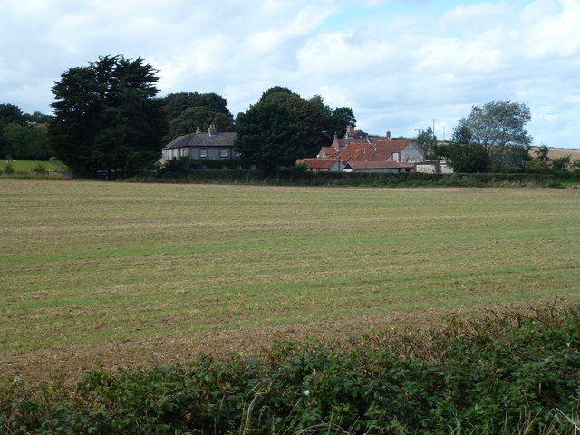
Eleven Acre Plantation, located in Norfolk, England, is a sprawling wood and forest area that spans over eleven acres of land. Situated in a picturesque countryside setting, the plantation is renowned for its natural beauty, diverse flora and fauna, and tranquil atmosphere.
The plantation features a variety of tree species, including oak, beech, and pine, creating a rich and vibrant woodland environment. The dense canopy formed by these trees provides shade and shelter for numerous wildlife species, making it an ideal habitat for birds, squirrels, rabbits, and deer, among others.
Visitors to Eleven Acre Plantation can enjoy a range of recreational activities, such as hiking, nature walks, and birdwatching. The well-maintained trails that wind through the plantation offer an opportunity to explore the enchanting forest, providing a sense of peace and serenity for nature enthusiasts.
The plantation also boasts a picnic area, allowing visitors to relax and enjoy the idyllic surroundings while having a meal or a snack. Additionally, there are several designated spots for camping, providing a unique opportunity for overnight stays amidst the natural splendor.
Eleven Acre Plantation is not only a haven for wildlife and nature lovers but also serves as an important conservation area. The preservation of this woodland ecosystem is of utmost importance, as it plays a vital role in maintaining biodiversity and providing a valuable green space for the local community.
Overall, Eleven Acre Plantation in Norfolk offers a remarkable experience for those seeking solace in nature. With its breathtaking scenery, diverse wildlife, and recreational opportunities, it is a must-visit destination for individuals looking to reconnect with the great outdoors.
If you have any feedback on the listing, please let us know in the comments section below.
Eleven Acre Plantation Images
Images are sourced within 2km of 52.946544/0.67774531 or Grid Reference TF8042. Thanks to Geograph Open Source API. All images are credited.


Eleven Acre Plantation is located at Grid Ref: TF8042 (Lat: 52.946544, Lng: 0.67774531)
Administrative County: Norfolk
District: King's Lynn and West Norfolk
Police Authority: Norfolk
What 3 Words
///printer.reputable.period. Near Wells-next-the-Sea, Norfolk
Nearby Locations
Related Wikis
Brancaster Staithe
Brancaster Staithe is a village on the north coast of the English county of Norfolk. Brancaster Staithe merges with Burnham Deepdale, forming one village...

St Mary's Church, Burnham Deepdale
St Mary's Church is a round-tower church in Burnham Deepdale, Norfolk, England. Its round tower and some other parts of the building date from the 11th...

Branodunum
Branodunum was an ancient Roman fort to the east of the modern English village of Brancaster in Norfolk. Its Roman name derives from the local Celtic language...

Burnham Westgate Hall
Burnham Westgate Hall is a Georgian country house near Burnham Market, Norfolk, about 2 mi (3.2 km) south of the north Norfolk coast. It was remodelled...

Brancaster
Brancaster is a village and civil parish on the north coast of the English county of Norfolk. The civil parish of Brancaster comprises Brancaster itself...

RAF Docking
Royal Air Force Docking or more simply RAF Docking is a former Royal Air Force satellite station a few miles from Bircham Newton in Norfolk, England....

Burnham Norton
Burnham Norton is a village and civil parish in the English county of Norfolk, one of the Burnhams, an adjacent group in the northernmost part of Norfolk...

Burnham Market
Burnham Market is an English village and civil parish near the north coast of Norfolk. It is one of the Burnhams, a group of three adjacent villages that...
Nearby Amenities
Located within 500m of 52.946544,0.67774531Have you been to Eleven Acre Plantation?
Leave your review of Eleven Acre Plantation below (or comments, questions and feedback).