Cresslands Plantation

Wood, Forest in Suffolk West Suffolk

England

Cresslands Plantation

St Mary's Church, Hawkedon
St Mary's Church, Hawkedon Credit: David Howard

Cresslands Plantation is a picturesque woodland located in Suffolk, England. Spanning across vast hectares of land, this plantation is a haven for nature enthusiasts and outdoor enthusiasts alike. The plantation is situated in a serene and tranquil setting, making it an ideal destination for those seeking solace and a break from the bustling city life.

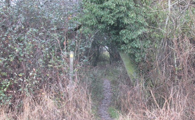
The woodland of Cresslands Plantation is primarily composed of a variety of trees, including oak, beech, and birch, which form a dense and lush forest canopy. These trees provide an ideal habitat for numerous species of flora and fauna, making it a biodiverse area.

Visitors to Cresslands Plantation can indulge in a plethora of activities. There are well-maintained walking trails that wind through the plantation, allowing visitors to explore the natural beauty at their own pace. The plantation is also a popular spot for birdwatching, as it attracts a wide range of bird species throughout the year.

Cresslands Plantation is not only a recreational area but also serves as an important ecological site. The woodland provides vital ecosystem services, including carbon sequestration and flood prevention. The careful management of the plantation ensures the preservation of its natural resources and the protection of its diverse wildlife.

Overall, Cresslands Plantation in Suffolk is a stunning woodland that offers a peaceful and immersive experience in nature. It showcases the beauty of Suffolk's natural landscapes and provides a sanctuary for both flora and fauna. Whether it's a leisurely walk or a chance to reconnect with nature, this plantation is a must-visit destination for nature enthusiasts and those seeking tranquility.

If you have any feedback on the listing, please let us know in the comments section below.

Cresslands Plantation Images

Images are sourced within 2km of 52.161932/0.62769905 or Grid Reference TL7954. Thanks to Geograph Open Source API. All images are credited.

St Mary's Church, Hawkedon
Broomagefield wood. Walking a footpath near Rede.
Broomagefield wood.
Walking a footpath near Rede.
Footpath through hedge near Rede hole. Taken on a walk to Suffolk's highest ground
Footpath through hedge near Rede hole.
Taken on a walk to Suffolk's highest ground
All Saints church, Rede. Colourful cottages beside the church.
All Saints church, Rede.
Colourful cottages beside the church.
Centenary seat and WW1 War Memorial at Hawkedon In Honour of those who served and in Memory of those who fell. 

NORFOLK - <a title="https://www.geograph.org.uk/article/War-Memorials-in-Norfolk" href="https://www.geograph.org.uk/article/War-Memorials-in-Norfolk">Link</a>
SUFFOLK - <a title="https://www.geograph.org.uk/article/War-Memorials-in-Suffolk" href="https://www.geograph.org.uk/article/War-Memorials-in-Suffolk">Link</a>
Centenary seat and WW1 War Memorial at Hawkedon
In Honour of those who served and in Memory of those who fell. NORFOLK - Link SUFFOLK - Link
The road across Hawkedon Green
Hawkedon First World War Memorial The memorial is an obolisk on an octagonal base.
It bears the names of nine men. There are no names recorded for WW2.
Hawkedon First World War Memorial
The memorial is an obolisk on an octagonal base. It bears the names of nine men. There are no names recorded for WW2.
Hawkedon church tower St. Mary's is a grade I listed building, 15th century.
Hawkedon church tower
St. Mary's is a grade I listed building, 15th century.
Grassed area in Hawkedon with houses beyond An extensive area of grass south-west of the church in Hawkedon.
Grassed area in Hawkedon with houses beyond
An extensive area of grass south-west of the church in Hawkedon.
Path beside ponds Two of the six ponds - artificially created of course - on the slope descending towards Cordell Hall.
Path beside ponds
Two of the six ponds - artificially created of course - on the slope descending towards Cordell Hall.
Road leading to mast The location at the camera position is reckoned to be the Suffolk county top.
Road leading to mast
The location at the camera position is reckoned to be the Suffolk county top.
Walkers along bridleway between fields The pair are heading south-west between fields close to Gatesbury's Farm.
Walkers along bridleway between fields
The pair are heading south-west between fields close to Gatesbury's Farm.
Bare earth south of Cresslands Farm There is actually an emerging crop coming through the gently sloping field. It's seen from a restricted byway which, some way to the north, past the farm, seems to lose that status, becoming simply a bridleway.
Bare earth south of Cresslands Farm
There is actually an emerging crop coming through the gently sloping field. It's seen from a restricted byway which, some way to the north, past the farm, seems to lose that status, becoming simply a bridleway.
Hawkedon House Hawkedon House is a large, brick-built, detached property close to the village of Hawkedon.
Hawkedon House
Hawkedon House is a large, brick-built, detached property close to the village of Hawkedon.
St. Mary's church, Hawkedon, Suffolk This is a 15th century church, which stands in the middle of a very large green with some interesting houses around it. One of the interesting features of the church is the fine south porch.
St. Mary's church, Hawkedon, Suffolk
This is a 15th century church, which stands in the middle of a very large green with some interesting houses around it. One of the interesting features of the church is the fine south porch.
'Queen's Head' public house, Hawkedon, Suffolk This is a very popular pub in this area and has a reputation for good food.
'Queen's Head' public house, Hawkedon, Suffolk
This is a very popular pub in this area and has a reputation for good food.
Suffolk's county top This mast, at Elms Farm, sits astride Suffolk's highest point, at 420 feet.
Suffolk's county top
This mast, at Elms Farm, sits astride Suffolk's highest point, at 420 feet.
Elms Farm, Depden This farm is situated some 200 metres from Suffolk's highest point.
Elms Farm, Depden
This farm is situated some 200 metres from Suffolk's highest point.
Show me another place!

Cresslands Plantation is located at Grid Ref: TL7954 (Lat: 52.161932, Lng: 0.62769905)

Administrative County: Suffolk

District: West Suffolk

Police Authority: Suffolk

What 3 Words

///megawatt.cone.trade. Near Glemsford, Suffolk

Related Wikis

Rede, Suffolk

Rede is a village and civil parish in the West Suffolk district of Suffolk in eastern England. Its location is situated South East of Chedburgh. In 1887...

Newmarket Ridge

The Newmarket Ridge or East Anglian Ridge is a ridge starting north-west of Hertford, Hertfordshire near the Chiltern Hills and ending near Sudbury, Suffolk...

Great Wood Hill

At 128 metres (420 ft), Great Wood Hill, near Chedburgh, is the highest point in the English county of Suffolk. It is the highest part of the Newmarket...

Hawkedon

Hawkedon is a village and civil parish in the West Suffolk district of Suffolk in eastern England. Located around 7 miles (11 km) south-south-west of Bury...

RAF Chedburgh

Royal Air Force Chedburgh or more simply RAF Chedburgh is a former Royal Air Force satellite station located near Bury St Edmunds, Suffolk, UK. The Bury...

Somerton, Suffolk

Somerton is a civil parish in the Babergh district of Suffolk in eastern England. Somerton is split into two smaller villages: Upper Somerton with a population...

Stansfield Windmill

Stansfield Mill is a Grade II listed tower mill at Stansfield, Suffolk, England which is derelict. == History == Stansfield Mill was built in 1840, replacing...

Depden

Depden is a village and civil parish in the West Suffolk district of Suffolk in eastern England. Located on the A143 around five miles south-west of Bury...

Have you been to Cresslands Plantation?

Leave your review of Cresslands Plantation below (or comments, questions and feedback).