Whites Wood

Wood, Forest in Kent

England

Whites Wood

Capstone Farm Country Park, near Gillingham Black headed gulls sitting on the footbridge over the lake.  Capstone Farm Country Park covers 114 hectares of former farmland set on the North Downs. There is a variety of habitats within the park, including ancient woodlands, old orchards, a freshwater lake, meadows and hedgerows.
Capstone Farm Country Park, near Gillingham Credit: pam fray

Whites Wood is a picturesque woodland located in the county of Kent, England. Covering an area of approximately 100 acres, it is nestled within the North Downs Area of Outstanding Natural Beauty. The wood is situated near the village of Stelling Minnis, just a short distance from the city of Canterbury.

Known for its diverse and ancient woodland, Whites Wood is home to a rich variety of flora and fauna. The woodland consists mainly of broadleaf species, including oak, beech, ash, and birch trees, which create a dense canopy overhead. The forest floor is adorned with bluebells, wild garlic, and other wildflowers in spring, making it a popular destination for nature enthusiasts and photographers.

Whites Wood offers a range of recreational activities for visitors to enjoy. There are several well-marked walking trails, providing opportunities for leisurely strolls and more challenging hikes. The wood is also a haven for birdwatchers, with numerous species such as woodpeckers, tits, and finches inhabiting the area.

In addition to its natural beauty, Whites Wood has a rich historical background. There are remnants of ancient earthworks within the wood, dating back to the Iron Age. These archaeological features add a fascinating element to the woodland, attracting history enthusiasts and researchers alike.

Overall, Whites Wood is a tranquil and idyllic woodland, offering a peaceful escape from the hustle and bustle of daily life. Its natural beauty, diverse wildlife, and historical significance make it a must-visit destination for anyone seeking a connection with nature and a glimpse into the past.

If you have any feedback on the listing, please let us know in the comments section below.

Whites Wood Images

Images are sourced within 2km of 51.355884/0.54501415 or Grid Reference TQ7764. Thanks to Geograph Open Source API. All images are credited.

Capstone Farm Country Park, near Gillingham Black headed gulls sitting on the footbridge over the lake.  Capstone Farm Country Park covers 114 hectares of former farmland set on the North Downs. There is a variety of habitats within the park, including ancient woodlands, old orchards, a freshwater lake, meadows and hedgerows.
Capstone Farm Country Park, near Gillingham
Black headed gulls sitting on the footbridge over the lake. Capstone Farm Country Park covers 114 hectares of former farmland set on the North Downs. There is a variety of habitats within the park, including ancient woodlands, old orchards, a freshwater lake, meadows and hedgerows.
Capstone Farm Country Park, near Gillingham Footpath to the east of the lake.  Capstone Farm Country Park covers 114 hectares of former farmland set on the North Downs. There is a variety of habitats within the park, including ancient woodlands, old orchards, a freshwater lake, meadows and hedgerows.
Capstone Farm Country Park, near Gillingham
Footpath to the east of the lake. Capstone Farm Country Park covers 114 hectares of former farmland set on the North Downs. There is a variety of habitats within the park, including ancient woodlands, old orchards, a freshwater lake, meadows and hedgerows.
Capstone Farm Country Park near Gillingham Capstone Farm Country Park covers 114 hectares of former farmland set on the North Downs. There is a variety of habitats within the park, including ancient woodlands, old orchards, a freshwater lake, meadows and hedgerows.
Capstone Farm Country Park near Gillingham
Capstone Farm Country Park covers 114 hectares of former farmland set on the North Downs. There is a variety of habitats within the park, including ancient woodlands, old orchards, a freshwater lake, meadows and hedgerows.
Capstone Farm Country  Park near Gillingham Capstone Farm Country Park covers 114 hectares of former farmland set on the North Downs. There is a variety of habitats within the park, including ancient woodlands, old orchards, a freshwater lake, meadows and hedgerows.
Capstone Farm Country Park near Gillingham
Capstone Farm Country Park covers 114 hectares of former farmland set on the North Downs. There is a variety of habitats within the park, including ancient woodlands, old orchards, a freshwater lake, meadows and hedgerows.
Capstone Farm Country Park near Gillingham View over the lake from the east side. Capstone Farm Country Park covers 114 hectares of former farmland set on the North Downs. There is a variety of habitats within the park, including ancient woodlands, old orchards, a freshwater lake, meadows and hedgerows.
Capstone Farm Country Park near Gillingham
View over the lake from the east side. Capstone Farm Country Park covers 114 hectares of former farmland set on the North Downs. There is a variety of habitats within the park, including ancient woodlands, old orchards, a freshwater lake, meadows and hedgerows.
Capstone Farm Country Park near Gillingham Capstone Farm Country Park covers 114 hectares of former farmland set on the North Downs. There is a variety of habitats within the park, including ancient woodlands, old orchards, a freshwater lake, meadows and hedgerows.
Capstone Farm Country Park near Gillingham
Capstone Farm Country Park covers 114 hectares of former farmland set on the North Downs. There is a variety of habitats within the park, including ancient woodlands, old orchards, a freshwater lake, meadows and hedgerows.
Capstone Farm Coountry Park near Gillingham Euonymus europaeus, or spindle tree.  Capstone Farm Country Park covers 114 hectares of former farmland set on the North Downs. There is a variety of habitats within the park, including ancient woodlands, old orchards, a freshwater lake, meadows and hedgerows.
Capstone Farm Coountry Park near Gillingham
Euonymus europaeus, or spindle tree. Capstone Farm Country Park covers 114 hectares of former farmland set on the North Downs. There is a variety of habitats within the park, including ancient woodlands, old orchards, a freshwater lake, meadows and hedgerows.
Capstone Farm Country  Park near Gillingham An acer in autumn colour. Capstone Farm Country Park covers 114 hectares of former farmland set on the North Downs. There is a variety of habitats within the park, including ancient woodlands, old orchards, a freshwater lake, meadows and hedgerows.
Capstone Farm Country Park near Gillingham
An acer in autumn colour. Capstone Farm Country Park covers 114 hectares of former farmland set on the North Downs. There is a variety of habitats within the park, including ancient woodlands, old orchards, a freshwater lake, meadows and hedgerows.
Capstone Farm Country Park near Gillingham One of the main paths with the trees showing autumn colour. Capstone Farm Country Park covers 114 hectares of former farmland set on the North Downs. There is a variety of habitats within the park, including ancient woodlands, old orchards, a freshwater lake, meadows and hedgerows.
Capstone Farm Country Park near Gillingham
One of the main paths with the trees showing autumn colour. Capstone Farm Country Park covers 114 hectares of former farmland set on the North Downs. There is a variety of habitats within the park, including ancient woodlands, old orchards, a freshwater lake, meadows and hedgerows.
The Old Ash Tree public house On Ash Tree Lane.
The Old Ash Tree public house
On Ash Tree Lane.
Sign for the Old Ash Tree public house
View across Ash Tree Lane This is at the junction with Capstone Road.
View across Ash Tree Lane
This is at the junction with Capstone Road.
Luton Recreation Ground This view is from near the car park looking towards Darland Banks.
Luton Recreation Ground
This view is from near the car park looking towards Darland Banks.
Darland Banks Darland Banks on the southern edge of Gillingham is a fine chalk grassland, interspersed with scrub and secondary woodland. The population of man orchids is one of the largest in the United Kingdom. The area has been accessible for more than a hundred years and the grassland slopes were historically used as common land for the grazing of cattle and sheep. The information board can be seen at <a title="https://www.geograph.org.uk/photo/7239164" href="https://www.geograph.org.uk/photo/7239164">Link</a>

This view is at the top of the climb up from Ash Tree Lane as Kingsway is reached.
Darland Banks
Darland Banks on the southern edge of Gillingham is a fine chalk grassland, interspersed with scrub and secondary woodland. The population of man orchids is one of the largest in the United Kingdom. The area has been accessible for more than a hundred years and the grassland slopes were historically used as common land for the grazing of cattle and sheep. The information board can be seen at Link This view is at the top of the climb up from Ash Tree Lane as Kingsway is reached.
Darland Banks Darland Banks on the southern edge of Gillingham is a fine chalk grassland, interspersed with scrub and secondary woodland. The population of man orchids is one of the largest in the United Kingdom. The area has been accessible for more than a hundred years and the grassland slopes were historically used as common land for the grazing of cattle and sheep. The information board can be seen at <a title="https://www.geograph.org.uk/photo/7239164" href="https://www.geograph.org.uk/photo/7239164">Link</a>

This view is at the top of the path down to Ash Tree Lane from Kingsway opposite Hunters Way.
Darland Banks
Darland Banks on the southern edge of Gillingham is a fine chalk grassland, interspersed with scrub and secondary woodland. The population of man orchids is one of the largest in the United Kingdom. The area has been accessible for more than a hundred years and the grassland slopes were historically used as common land for the grazing of cattle and sheep. The information board can be seen at Link This view is at the top of the path down to Ash Tree Lane from Kingsway opposite Hunters Way.
Information board for Darland Banks Darland Banks on the southern edge of Gillingham is a fine chalk grassland, interspersed with scrub and secondary woodland. The population of man orchids is one of the largest in the United Kingdom. The area has been accessible for more than a hundred years and the grassland slopes were historically used as common land for the grazing of cattle and sheep. 

This information board is at the top of the path down to Ash Tree Lane from Kingsway opposite Hunters Way. Its view can be seen at <a title="https://www.geograph.org.uk/photo/7239167" href="https://www.geograph.org.uk/photo/7239167">Link</a>
Information board for Darland Banks
Darland Banks on the southern edge of Gillingham is a fine chalk grassland, interspersed with scrub and secondary woodland. The population of man orchids is one of the largest in the United Kingdom. The area has been accessible for more than a hundred years and the grassland slopes were historically used as common land for the grazing of cattle and sheep. This information board is at the top of the path down to Ash Tree Lane from Kingsway opposite Hunters Way. Its view can be seen at Link
View over Darland Banks Darland Banks on the southern edge of Gillingham is a fine chalk grassland, interspersed with scrub and secondary woodland. The population of man orchids is one of the largest in the United Kingdom. The area has been accessible for more than a hundred years and the grassland slopes were historically used as common land for the grazing of cattle and sheep. 

This view is at the top of the path down to Ash Tree Lane from Kingsway opposite Hunters Way. A close up of the information board can be seen at <a title="https://www.geograph.org.uk/photo/7239164" href="https://www.geograph.org.uk/photo/7239164">Link</a>
View over Darland Banks
Darland Banks on the southern edge of Gillingham is a fine chalk grassland, interspersed with scrub and secondary woodland. The population of man orchids is one of the largest in the United Kingdom. The area has been accessible for more than a hundred years and the grassland slopes were historically used as common land for the grazing of cattle and sheep. This view is at the top of the path down to Ash Tree Lane from Kingsway opposite Hunters Way. A close up of the information board can be seen at Link
Show me another place!

Whites Wood is located at Grid Ref: TQ7764 (Lat: 51.355884, Lng: 0.54501415)

Unitary Authority: Medway

Police Authority: Kent

What 3 Words

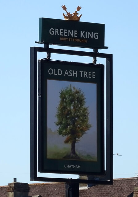
///rolled.modules.buckets. Near Chatham, Kent

Related Wikis

Capstone Farm Country Park

Capstone Farm Country Park is in Chatham, Kent, Medway, in Kent, England. A former farm converted into a landscaped park and open-space area. This park...

Walderslade Girls' School

Walderslade Girls' School is a secondary school and sixth form for girls located in Walderslade in the English county of Kent. == Governance == The school...

Chatham (UK Parliament constituency)

Chatham was a parliamentary constituency in Kent which returned one Member of Parliament (MP) to the House of Commons of the Parliament of the United Kingdom...

Greenacre Academy

Greenacre Academy (formerly Greenacre School and before that Walderslade Boys School), is a boys' secondary school with shared sixth form located in Walderslade...
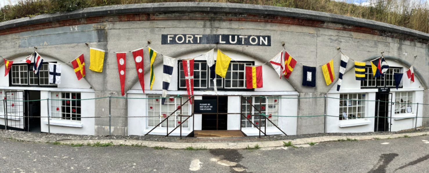
Fort Luton

Fort Luton was built between 1876 and 1892 south of Chatham, Medway, South East England. It is one of the five late Victorian land front forts built to...
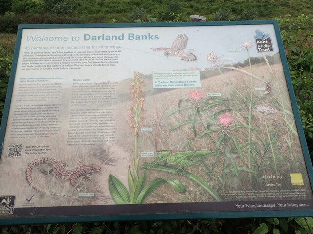
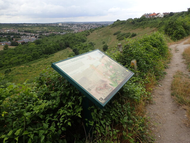
Darland Banks

Darland Banks is a 29.1-hectare (72-acre) Local Nature Reserve on the southern outskirts of Gillingham in Kent. It is owned by Medway Council and managed...

Lordswood F.C.

Lordswood Football Club is a football club based in the Lordswood suburb of Chatham, England. They are currently members of the Southern Counties East...

The Victory Academy

The Victory Academy (formerly Bishop of Rochester Academy and Medway Community College) is a mixed secondary school and sixth form located in Chatham in...

Nearby Amenities

Located within 500m of 51.355884,0.54501415
Turning Circle
Lat/Long: 51.3537493/0.5430674
Turning Circle
Lat/Long: 51.3531129/0.542726
Turning Circle
Lat/Long: 51.3536281/0.5418311
Turning Circle
Lat/Long: 51.3534164/0.5412748
Turning Circle
Lat/Long: 51.3529302/0.5408225
Turning Circle
Lat/Long: 51.3525184/0.5426981
Turning Circle
Lat/Long: 51.3560797/0.5410359
Turning Circle
Lat/Long: 51.3543528/0.5399343
Turning Circle
Lat/Long: 51.355492/0.5402682
Turning Circle
Lat/Long: 51.3547449/0.5390639
Turning Circle
Lat/Long: 51.3549693/0.5379763
Turning Circle
Lat/Long: 51.3561358/0.5397318
Turning Circle
Lat/Long: 51.3585283/0.5445056
Turning Circle
Lat/Long: 51.3579351/0.5435933
Turning Circle
Lat/Long: 51.3575058/0.544281
Turning Circle
Lat/Long: 51.3573024/0.54306
Turning Circle
Lat/Long: 51.3568872/0.5439489
Turning Circle
Lat/Long: 51.3568027/0.5425618
Turning Circle
Lat/Long: 51.3551775/0.5433018
Turning Circle
Lat/Long: 51.3555718/0.5425691
Turning Circle
Lat/Long: 51.355846/0.5435824
Turning Circle
Lat/Long: 51.3563529/0.5436292
Turning Circle
Lat/Long: 51.3578965/0.5422149
Turning Circle
Lat/Long: 51.3584516/0.5440366
Bus Stop
Swift Crescent
Bench: no
Bin: no
Bus: yes
Lit: no
Naptan AtcoCode: 249000000232
Naptan Bearing: SW
Naptan CommonName: Swift Crescent
Naptan Indicator: adj
Naptan Landmark: Swift Crescent
Naptan NaptanCode: chadtda
Naptan PlusbusZoneRef: MEDWAY
Naptan Street: Princes Avenue
Naptan Verified: no
Public Transport: platform
Shelter: no
Source: naptan_import
Tactile Paving: no
Lat/Long: 51.3567081/0.5406291
Bus Stop
Kingfisher Drive
Bus: yes
Naptan AtcoCode: 249000000537
Naptan Bearing: SW
Naptan CommonName: Kingfisher Drive
Naptan Indicator: SW-bound
Naptan Landmark: Kingfisher Drive
Naptan NaptanCode: chagmwp
Naptan PlusbusZoneRef: MEDWAY
Naptan Street: Princes Avenue
Naptan Verified: no
Public Transport: platform
Source: naptan_import
Lat/Long: 51.3583672/0.5433354
Bus Stop
Kingfisher Drive
Bench: yes
Bin: yes
Bus: yes
Naptan AtcoCode: 249000000538
Naptan Bearing: NE
Naptan CommonName: Kingfisher Drive
Naptan Indicator: NE-bound
Naptan Landmark: Kingfisher Drive
Naptan NaptanCode: chagmwt
Naptan PlusbusZoneRef: MEDWAY
Naptan Street: Princes Avenue
Naptan Verified: no
Public Transport: platform
Shelter: yes
Source: naptan_import
Lat/Long: 51.3578689/0.5426757
Bus Stop
Devon Close
Naptan AtcoCode: 249000000539
Naptan Bearing: N
Naptan CommonName: Devon Close
Naptan Indicator: opp
Naptan Landmark: Devon Close
Naptan NaptanCode: chagpad
Naptan PlusbusZoneRef: MEDWAY
Naptan Street: Heron Way
Naptan Verified: no
Source: naptan_import
Lat/Long: 51.3595926/0.5436475
Bus Stop
Heron Way Devon Close
Bus: yes
Naptan AtcoCode: 249000000540
Naptan Bearing: S
Naptan CommonName: Heron Way Devon Close
Naptan Indicator: adj
Naptan Landmark: Devon Close
Naptan NaptanCode: chagpag
Naptan PlusbusZoneRef: MEDWAY
Naptan Street: Heron Way
Naptan Verified: no
Public Transport: platform
Source: naptan_import
Lat/Long: 51.3599633/0.5439698
Bus Stop
Shawstead Road
Bus: yes
Naptan AtcoCode: 249000000867
Naptan Bearing: N
Naptan CommonName: Shawstead Road
Naptan Indicator: opp
Naptan Landmark: Princes Avenue
Naptan NaptanCode: chajmgm
Naptan PlusbusZoneRef: MEDWAY
Naptan Street: North Dane Way
Naptan Verified: no
Public Transport: platform
Source: naptan_import
Lat/Long: 51.3575372/0.5446972
Crossing
Crossing: unmarked
Crossing Island: yes
Kerb: lowered
Tactile Paving: yes
Lat/Long: 51.3569843/0.5415323
Turning Circle
Lat/Long: 51.3564539/0.5383029
Turning Circle
Lat/Long: 51.3568958/0.5395153
Crossing
Crossing: unmarked
Crossing Island: yes
Tactile Paving: yes
Lat/Long: 51.3571578/0.5418302
Crossing
Crossing: uncontrolled
Lat/Long: 51.3581355/0.5410697
Post Box
Collection Times: Mo-Fr 09:00; Sa 07:00
Operator: Royal Mail
Post Box Type: lamp
Ref: ME5 406D
Royal Cypher: EIIR
Royal Cypher Wikidata: Q33102113
Lat/Long: 51.3565792/0.5414985
Grit Bin
Access: yes
Operator: Medway Council
Ref: SB329
Source: survey
Lat/Long: 51.3532627/0.5422018
Grit Bin
Access: yes
Operator: Medway Council
Ref: SB164
Source: survey
Lat/Long: 51.3552393/0.5395988
Grit Bin
Access: yes
Operator: Medway Council
Ref: SB162
Source: survey
Lat/Long: 51.3549914/0.5412551
Grit Bin
Access: yes
Operator: Medway Council
Ref: SB385
Source: survey
Lat/Long: 51.3571219/0.5433485
Grit Bin
Access: yes
Operator: Medway Council
Ref: SB385
Source: survey
Lat/Long: 51.355916/0.5431446
Grit Bin
Access: yes
Operator: Medway Council
Ref: SB126
Source: survey
Lat/Long: 51.3566664/0.5431339
Grit Bin
Access: yes
Operator: Medway Council
Ref: SB163
Source: survey
Lat/Long: 51.3563381/0.5423722
Grit Bin
Access: yes
Operator: Medway Council
Ref: SB142
Source: survey
Lat/Long: 51.3575951/0.5418169
Grit Bin
Access: yes
Operator: Medway Council
Ref: SB141
Source: survey
Lat/Long: 51.3589597/0.5416015
Grit Bin
Access: yes
Ref: SB169
Source: survey
Lat/Long: 51.3597683/0.5428845
Power: pole
Lat/Long: 51.3538976/0.5469453
Power: pole
Lat/Long: 51.3548842/0.5464411
Power: pole
Lat/Long: 51.3553582/0.5461889
Design: guyed_h-frame
Line Management: transition
Location Transition: yes
Power: tower
Lat/Long: 51.3561856/0.5457598
Power: pole
Lat/Long: 51.3523556/0.5477862
Power: pole
Lat/Long: 51.3530207/0.5474476
Crossing
Crossing: unmarked
Crossing Island: yes
Tactile Paving: yes
Lat/Long: 51.3566471/0.5400266
Crossing
Crossing: unmarked
Crossing Island: yes
Tactile Paving: yes
Lat/Long: 51.3562124/0.5384065
Generator Method: photovoltaic
Generator Output Electricity: yes
Generator Source: solar
Generator Type: solar_photovoltaic_panel
Location: roof
Power: generator
Lat/Long: 51.355158/0.5420919
Generator Method: photovoltaic
Generator Output Electricity: yes
Generator Source: solar
Generator Type: solar_photovoltaic_panel
Location: roof
Power: generator
Lat/Long: 51.3539629/0.5406046
Generator Method: photovoltaic
Generator Output Electricity: yes
Generator Source: solar
Generator Type: solar_photovoltaic_panel
Location: roof
Power: generator
Lat/Long: 51.3524218/0.5406475
Generator Method: photovoltaic
Generator Output Electricity: yes
Generator Source: solar
Generator Type: solar_photovoltaic_panel
Location: roof
Power: generator
Lat/Long: 51.3532007/0.5428442
Generator Method: photovoltaic
Generator Output Electricity: yes
Generator Source: solar
Generator Type: solar_photovoltaic_panel
Location: roof
Power: generator
Lat/Long: 51.3533632/0.5431366
Generator Method: photovoltaic
Generator Output Electricity: yes
Generator Source: solar
Generator Type: solar_photovoltaic_panel
Location: roof
Power: generator
Lat/Long: 51.3550148/0.5419779
Generator Method: photovoltaic
Generator Output Electricity: yes
Generator Source: solar
Generator Type: solar_photovoltaic_panel
Location: roof
Power: generator
Lat/Long: 51.357477/0.543445
Generator Method: photovoltaic
Generator Output Electricity: yes
Generator Source: solar
Generator Type: solar_photovoltaic_panel
Location: roof
Power: generator
Lat/Long: 51.3581269/0.5443168
Generator Method: photovoltaic
Generator Output Electricity: yes
Generator Source: solar
Generator Type: solar_photovoltaic_panel
Location: roof
Power: generator
Lat/Long: 51.3584384/0.5448157
Give Way
Direction: forward
Lat/Long: 51.358601/0.5452139
The data included in this document is from www.openstreetmap.org. The data is made available under ODbL.

Have you been to Whites Wood?

Leave your review of Whites Wood below (or comments, questions and feedback).