Fintry

Settlement in Stirlingshire

Scotland

Fintry

Gate above Balglass Gateway on the Campsie Fells, below the wide open spaces of rough grazing that make up this square.
Gate above Balglass Credit: Richard Webb

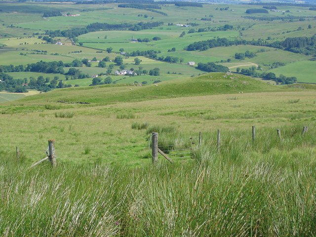
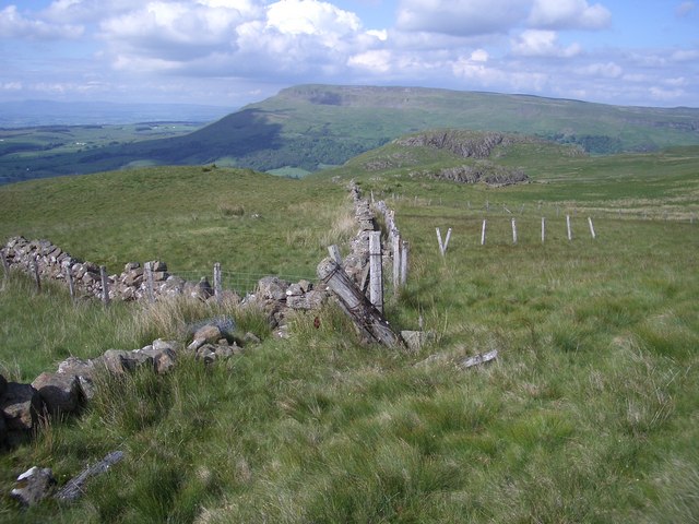
Fintry is a small village located in the Stirling council area of Scotland. Nestled in the picturesque Fintry Hills, it is situated about 15 miles north of the city of Stirling. With a population of around 1,000 residents, Fintry is known for its tranquil and rural setting, making it an ideal place for those seeking a quiet countryside retreat.

The village is rich in history, dating back to the 17th century when it was established as a rural settlement. Its name, derived from the Gaelic word "fionn traigh," means "fair strand" or "fair beach," possibly referencing a sandy area along the River Endrick that runs through the village.

Fintry boasts a range of amenities for its residents and visitors. The village has a primary school, a community center, and a local pub, providing a sense of community and social interaction. There are also several walking trails and nature reserves nearby, allowing outdoor enthusiasts to explore the surrounding natural beauty.

One of the prominent landmarks in Fintry is the 19th-century Fintry Estate, which includes a grand manor house and beautiful gardens. The estate is open to the public, offering guided tours and occasional events throughout the year. Additionally, the village hosts an annual Fintry Gala Day, which showcases local talent, crafts, and activities for all ages.

Overall, Fintry is a charming village that offers a peaceful and scenic environment, making it an appealing destination for nature lovers and those seeking a slower pace of life in the heart of the Scottish countryside.

If you have any feedback on the listing, please let us know in the comments section below.

Fintry Images

Images are sourced within 2km of 56.055617/-4.225717 or Grid Reference NS6186. Thanks to Geograph Open Source API. All images are credited.

Gate above Balglass Gateway on the Campsie Fells, below the wide open spaces of rough grazing that make up this square.
Gate above Balglass
Gateway on the Campsie Fells, below the wide open spaces of rough grazing that make up this square.
Walls and fences Crumbling dry stone walls have been replaced by fences which are now showing their age.
A view to Dunmore and Stronend.
Walls and fences
Crumbling dry stone walls have been replaced by fences which are now showing their age. A view to Dunmore and Stronend.
Fintry Youth Hostel by Endrick Water, Stirling North of the Campsie Fells, this was one of Scotland's earliest hostels, opening in 1935. It was popular with weekenders from Glasgow. The hostel closed in 1981 being by then structurally unsound, and was demolished. (Details from John Martin)

Scanned from an Agfa colour slide, circa mid 1970s in August. It may not be 1975.
Fintry Youth Hostel by Endrick Water, Stirling
North of the Campsie Fells, this was one of Scotland's earliest hostels, opening in 1935. It was popular with weekenders from Glasgow. The hostel closed in 1981 being by then structurally unsound, and was demolished. (Details from John Martin) Scanned from an Agfa colour slide, circa mid 1970s in August. It may not be 1975.
Driveway, Knockraich Knockraich is home to a very good cafe.
Driveway, Knockraich
Knockraich is home to a very good cafe.
Fintry Kirk Photo taken circa 1990 (Fuji Velvia 35mm film)
Fintry Kirk
Photo taken circa 1990 (Fuji Velvia 35mm film)
Scrub vegetation on slope east of B822 Rough grass and some scrub-like vegetation on the slope which rises ultimately to rock bands below Stronend via an intermediate location named as Skiddaw.
Scrub vegetation on slope east of B822
Rough grass and some scrub-like vegetation on the slope which rises ultimately to rock bands below Stronend via an intermediate location named as Skiddaw.
Farmland, Strathendrick Arable land with some infertile looking upland area in the background.
Farmland, Strathendrick
Arable land with some infertile looking upland area in the background.
Low Bridge, B818 Takes the Fintry to Denny Road  across Endrick Water.
Low Bridge, B818
Takes the Fintry to Denny Road across Endrick Water.
Endrick Water, Low Bridge For view in another season see <a href="https://www.geograph.org.uk/photo/1198189">NS6386 : Endrick Water</a>.
Endrick Water, Low Bridge
For view in another season see NS6386 : Endrick Water.
Strathendrick A gate, long out of use on the flat glen floor.
Strathendrick
A gate, long out of use on the flat glen floor.
Bogside under Skiddaw Flat land in Strathendrick contrasts with the trap hills  of the Fintry-Gargunnock hills.  Skiddaw is the profile of one of the horizontal lava beds.
Bogside under Skiddaw
Flat land in Strathendrick contrasts with the trap hills of the Fintry-Gargunnock hills. Skiddaw is the profile of one of the horizontal lava beds.
Fintry Westward along Main Street.  Unusually there was some evidence of jubilee celebrations here.
Fintry
Westward along Main Street. Unusually there was some evidence of jubilee celebrations here.
Farmland in Strathendrick Flat grassland west of Fintry.
Farmland in Strathendrick
Flat grassland west of Fintry.
Glenboig Wood Birch woods near Fintry. Birch woods without very old trees are often former farmland.
Glenboig Wood
Birch woods near Fintry. Birch woods without very old trees are often former farmland.
Fintry Road Junction Looking along the B822, the Crow Road from Lennoxtown towards the junction where the B822 continues to the right to Kippen and the B818 leads straight on to Killearn and Balfron.
Fintry Road Junction
Looking along the B822, the Crow Road from Lennoxtown towards the junction where the B822 continues to the right to Kippen and the B818 leads straight on to Killearn and Balfron.
Fintry Kirk About 1 kilometre outside Fintry on the B822.
Fintry Kirk
About 1 kilometre outside Fintry on the B822.
Site of Dunmore Hill Fort The craggy knolls on the right are marked on the map as the site of the fort.  Stronend, which lies on the opposite side of the Endrick valley, is the hill in shadow in the background
Site of Dunmore Hill Fort
The craggy knolls on the right are marked on the map as the site of the fort. Stronend, which lies on the opposite side of the Endrick valley, is the hill in shadow in the background
Kilewnan Burn The burn drops steeply off the Campsie Fells through this ravine.
Kilewnan Burn
The burn drops steeply off the Campsie Fells through this ravine.
Show me another place!

Fintry is located at Grid Ref: NS6186 (Lat: 56.055617, Lng: -4.225717)

Unitary Authority: Stirling

Police Authority: Forth Valley

What 3 Words

///shampoos.motels.like. Near Balfron, Stirling

Nearby Locations

Fintry Wood Fintry

Related Wikis

Fintry

Fintry is a small riverside village in Stirlingshire, central Scotland. It is located 16 miles (26 km) south-west of Stirling and around 19 miles (31 km...

Culcreuch Castle

Culcreuch Castle is a Scottish castle close to the village of Fintry, near Loch Lomond. It had been the home of the Barons of Culcreuch since 1699. In...
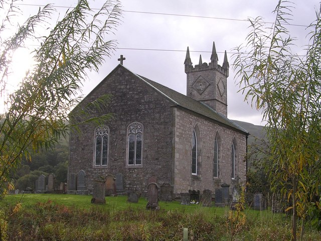
Fintry Kirk

Fintry Kirk is in the village of Fintry in Stirlingshire, Scotland. Fintry is a Church of Scotland Parish in the Presbytery of Stirling. The kirk is located...

Fintry Castle, Stirling

Fintry Castle, was a 15th-century castle near Fintry, Stirling, Scotland. The castle was built on the northern slopes of the valley of the Endrick Water...

Nearby Amenities

Located within 500m of 56.055617,-4.225717
Fintry
Is In: Stirlingshire, Scotland, UK
Name En: Fintry
Name Gd: Fionn-treabh
Place: village
Population: 690
Wikidata: Q1026796
Wikipedia: en:Fintry
Lat/Long: 56.053149/-4.2234194
Fountain
Coronation of Edward VII
Historic: memorial
Source: survey
Lat/Long: 56.0532613/-4.2238184
Post Box
Collection Times: Mo-Fr 15:45, Sa 12:00
Post Box Type: pillar
Ref: G63 565
Royal Cypher: scottish_crown
Source: survey
Lat/Long: 56.0527197/-4.2221555
Telephone
Red telephone box
Booth: K6
Covered: booth
Listed Status: Category B
Lat/Long: 56.0536382/-4.2251411
Pub
Fintry Inn
Note: After closing during the Covid-19 pandemic, Fintry Inn has re-opened under new management as of June 2022
Lat/Long: 56.0528295/-4.2230264
Ford: yes
Lat/Long: 56.0518537/-4.2271646
Power: pole
Lat/Long: 56.0535049/-4.2192479
Power: pole
Lat/Long: 56.053763/-4.2205364
Power: pole
Lat/Long: 56.0540235/-4.2218144
Power: pole
Lat/Long: 56.0542255/-4.2228519
Power: pole
Lat/Long: 56.0543529/-4.223971
Power: pole
Lat/Long: 56.0543797/-4.2241446
Power: pole
Lat/Long: 56.0530119/-4.2195742
Power: pole
Lat/Long: 56.0559332/-4.2281284
Power: pole
Lat/Long: 56.0563899/-4.2297411
Power: pole
Lat/Long: 56.0567017/-4.2306635
Power: pole
Lat/Long: 56.0570019/-4.231586
Power: pole
Lat/Long: 56.0573149/-4.232567
Power: pole
Lat/Long: 56.0576875/-4.2322846
Power: pole
Lat/Long: 56.0580776/-4.2319876
The data included in this document is from www.openstreetmap.org. The data is made available under ODbL.

Have you been to Fintry?

Leave your review of Fintry below (or comments, questions and feedback).