Damerood Belt

Wood, Forest in Norfolk King's Lynn and West Norfolk

England

Damerood Belt

Roundabout on A149 Added to access a new housing development on the southern edge of Hunstanton.
Roundabout on A149 Credit: Hugh Venables

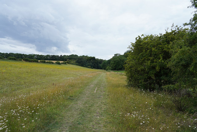
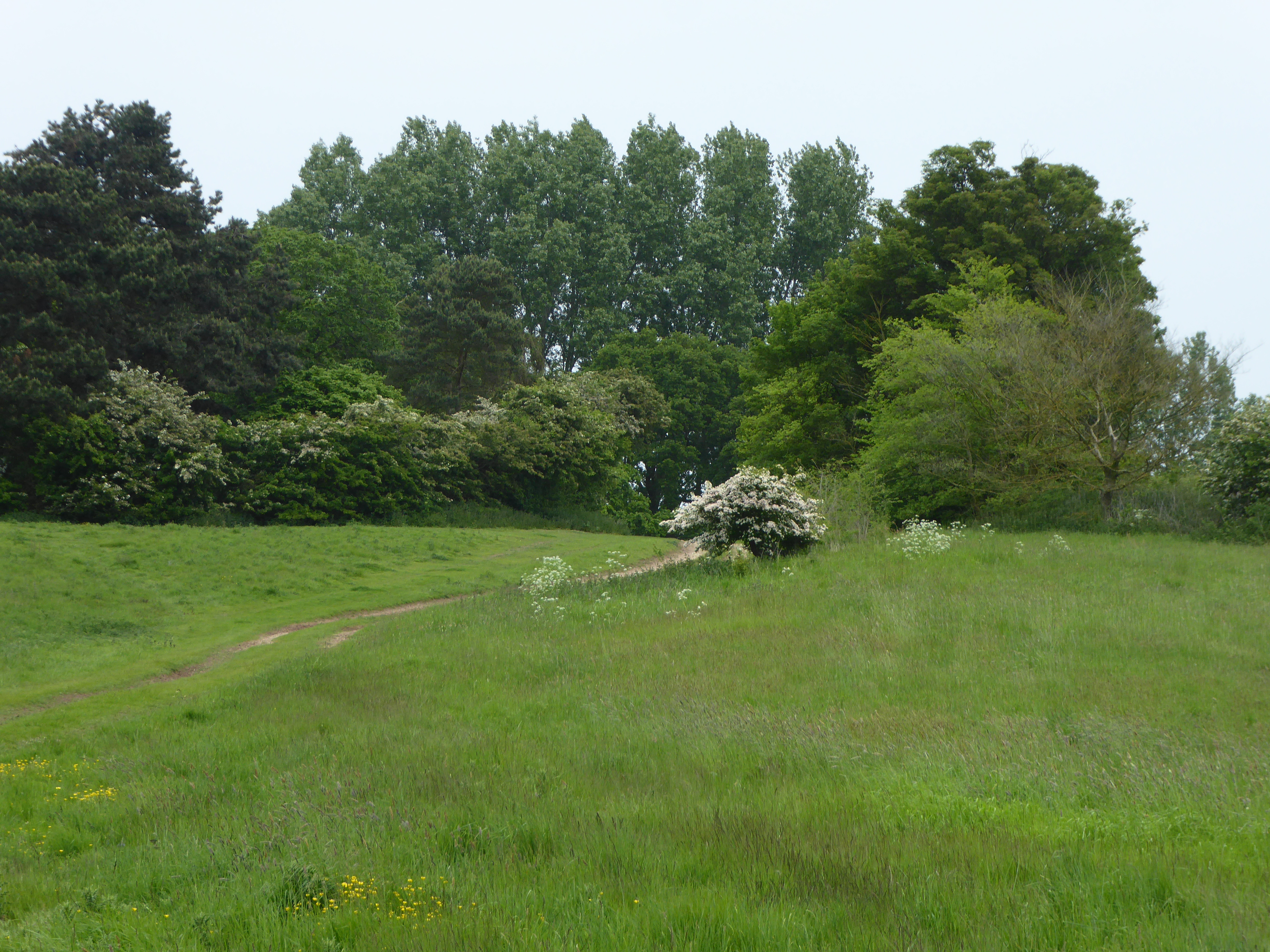
Damerood Belt, located in Norfolk, England, is a picturesque wood or forest area that attracts nature enthusiasts and adventurers alike. Covering an expansive area, this woodland is known for its diverse flora and fauna, offering visitors a unique and immersive experience in the heart of nature.

As one explores Damerood Belt, they will encounter a rich variety of tree species, including oak, beech, and birch, among others. The dense canopy created by these towering trees provides a haven for countless bird species, making it a popular spot for birdwatching enthusiasts. The woodland floor is also home to a vibrant array of wildflowers, adding a splash of color to the verdant surroundings.

The diverse ecosystem of Damerood Belt supports a wide range of wildlife, making it a haven for animal lovers. Visitors may catch a glimpse of deer gracefully roaming through the trees, or spot smaller mammals such as rabbits and squirrels scurrying about. The tranquil environment is also home to a variety of insects and butterflies, adding to the biodiversity of the area.

For those seeking outdoor activities, Damerood Belt offers numerous walking trails and paths that wind through the wood. These trails cater to all levels of fitness, from leisurely strolls to more challenging hikes. The enchanting atmosphere of the forest provides an ideal backdrop for a peaceful and rejuvenating walk.

In conclusion, Damerood Belt in Norfolk is a captivating woodland area, offering visitors a chance to immerse themselves in the beauty of nature. With its diverse plant and animal life, as well as its tranquil walking trails, this forest provides a serene escape from the hustle and bustle of everyday life.

If you have any feedback on the listing, please let us know in the comments section below.

Damerood Belt Images

Images are sourced within 2km of 52.92764/0.52178437 or Grid Reference TF6939. Thanks to Geograph Open Source API. All images are credited.

Roundabout on A149 Added to access a new housing development on the southern edge of Hunstanton.
Roundabout on A149
Added to access a new housing development on the southern edge of Hunstanton.
Butterfield Meadow, Hunstanton New housing development on the southern edge of the town.
Butterfield Meadow, Hunstanton
New housing development on the southern edge of the town.
Hunstanton Road Between Heacham and Hunstanton.
Hunstanton Road
Between Heacham and Hunstanton.
Chalk River Road, Hunstanton New housing development on the southern edge of the town.
Chalk River Road, Hunstanton
New housing development on the southern edge of the town.
Butterfield Meadow, Hunstanton New housing develop on the southern edge of the town.
Butterfield Meadow, Hunstanton
New housing develop on the southern edge of the town.
Chalk River Road into Hunstanton New housing develop on the southern edge of the town.
Chalk River Road into Hunstanton
New housing develop on the southern edge of the town.
Smithdon School, Hunstanton Built as Hunstanton Secondary Modern School in 1949-1954, this building was designed by Peter and Alison Smithson, leading lights in the post-war "Brutalist" movement in architecture (contrary to what one might imagine, it got its name from the French “béton brut”, untreated concrete, rather than from any comment on its sympathy or lack of it).  Further details of the Smithsons can be found at <span class="nowrap"><a title="http://en.wikipedia.org/wiki/Alison_and_Peter_Smithson" rel="nofollow ugc noopener" href="http://en.wikipedia.org/wiki/Alison_and_Peter_Smithson">Link</a><img style="margin-left:2px;" alt="External link" title="External link - shift click to open in new window" src="https://s1.geograph.org.uk/img/external.png" width="10" height="10"/></span>.
The northern aspect of the building can be seen at <a href="https://www.geograph.org.uk/photo/3436429">TF6740 : Smithdon High School</a>.
Smithdon School, Hunstanton
Built as Hunstanton Secondary Modern School in 1949-1954, this building was designed by Peter and Alison Smithson, leading lights in the post-war "Brutalist" movement in architecture (contrary to what one might imagine, it got its name from the French “béton brut”, untreated concrete, rather than from any comment on its sympathy or lack of it). Further details of the Smithsons can be found at LinkExternal link. The northern aspect of the building can be seen at TF6740 : Smithdon High School.
Old Milestone Old milestone on the A149 at Hunstanton, Norfolk. The top of the milestone features a rivet benchmark <span class="nowrap"><a title="http://www.bench-marks.org.uk/bm43107" rel="nofollow ugc noopener" href="http://www.bench-marks.org.uk/bm43107">Link</a><img style="margin-left:2px;" alt="External link" title="External link - shift click to open in new window" src="https://s1.geograph.org.uk/img/external.png" width="10" height="10"/></span>. For overall view see <a title="https://www.geograph.org.uk/photo/2667292" href="https://www.geograph.org.uk/photo/2667292">Link</a>
Old Milestone
Old milestone on the A149 at Hunstanton, Norfolk. The top of the milestone features a rivet benchmark LinkExternal link. For overall view see Link
Kings Lynn 15 Old milestone on the A149 near to Hunstanton, Norfolk.  For a closer view see <a title="https://www.geograph.org.uk/photo/2667290" href="https://www.geograph.org.uk/photo/2667290">Link</a>
Kings Lynn 15
Old milestone on the A149 near to Hunstanton, Norfolk. For a closer view see Link
Smithdon High School The school, in Downs Road, was completed in 1954 to a design by Alison and Peter Smithson and is believed to be the earliest example in western Europe of the Brutalist style of architecture.  It has aroused strong feelings of either love or loathing among the generations of pupils and teachers who have had to work within its confines.  The black panels beneath the windows were installed, along with wooden sub-frames, in the 1980s in an attempt to mitigate the huge temperature differences arising from the original full-height glazing which was attached directly to the steel frame of the building, causing the glass either to fall out or simply to shatter as the frame expanded or contracted with temperature changes.

For a view of the south front see <a href="https://www.geograph.org.uk/photo/2341065">TF6740 : Smithdon School, Hunstanton</a>.
Smithdon High School
The school, in Downs Road, was completed in 1954 to a design by Alison and Peter Smithson and is believed to be the earliest example in western Europe of the Brutalist style of architecture. It has aroused strong feelings of either love or loathing among the generations of pupils and teachers who have had to work within its confines. The black panels beneath the windows were installed, along with wooden sub-frames, in the 1980s in an attempt to mitigate the huge temperature differences arising from the original full-height glazing which was attached directly to the steel frame of the building, causing the glass either to fall out or simply to shatter as the frame expanded or contracted with temperature changes. For a view of the south front see TF6740 : Smithdon School, Hunstanton.
Lovers Lane - Hunstanton Looking Southeast
Lovers Lane - Hunstanton
Looking Southeast
Milestone, A149
Milestone, A149
Old Milestone by the A149, King's Lynn Road, Old Hunstanton Carved stone post by the A149, in parish of OLD HUNSTANTON (KINGS LYNN AND WEST NORFOLK District), entrance to Hunstanton Commercial Park, King's Lynn Road, on the verge, on East side of road. Lynn pillar, erected by an unknown authority in the 19th century. 

Inscription reads:- : 15 / TO / LYNN / Hunstanton : 
Carved bench mark and rivet on top.

Milestone Society National ID: NO_KLW15.
Old Milestone by the A149, King's Lynn Road, Old Hunstanton
Carved stone post by the A149, in parish of OLD HUNSTANTON (KINGS LYNN AND WEST NORFOLK District), entrance to Hunstanton Commercial Park, King's Lynn Road, on the verge, on East side of road. Lynn pillar, erected by an unknown authority in the 19th century. Inscription reads:- : 15 / TO / LYNN / Hunstanton : Carved bench mark and rivet on top. Milestone Society National ID: NO_KLW15.
Ringstead Downs Nature Reserve Looking back the way we have walked through the nature reserve.
Ringstead Downs Nature Reserve
Looking back the way we have walked through the nature reserve.
Looking down the valley Looking down the valley before the side become really steep.
Looking down the valley
Looking down the valley before the side become really steep.
Near the end of the reserve Just below this view are some farm buildings so we are approximately at the end of the nature reserve.
Near the end of the reserve
Just below this view are some farm buildings so we are approximately at the end of the nature reserve.
Redgate Hill Roundabout This roundabout and road to the coast from here is not shown on the old O/S map which accompanies this series
Redgate Hill Roundabout
This roundabout and road to the coast from here is not shown on the old O/S map which accompanies this series
Looking south along A149 from Redgate Hill Roundabout This south looking view shows A149 on a quiet winter afternoon. At the bottom of the hill is a road junction with a road off to the right to Heacham
Looking south along A149 from Redgate Hill Roundabout
This south looking view shows A149 on a quiet winter afternoon. At the bottom of the hill is a road junction with a road off to the right to Heacham
Show me another place!

Damerood Belt is located at Grid Ref: TF6939 (Lat: 52.92764, Lng: 0.52178437)

Administrative County: Norfolk

District: King's Lynn and West Norfolk

Police Authority: Norfolk

What 3 Words

///clockwork.chimp.iterative. Near Hunstanton, Norfolk

Related Wikis

Ringstead Downs

Ringstead Downs is a 6.9-hectare (17-acre) biological Site of Special Scientific Interest east of Hunstanton in Norfolk. It is in the Norfolk Coast Area...

Hunstanton Park Esker

Hunstanton Park Esker is a 17.3-hectare (43-acre) geological Site of Special Scientific Interest east of Hunstanton in Norfolk. The esker extends 1.5 km...

Ringstead, Norfolk

Ringstead is a village and civil parish in the north-west corner of the English county of Norfolk. It covers an area of 11.13 km2 (4.30 sq mi) and had...

Paul Nicholas School of Acting & Performing Arts

The Paul Nicholas School of Acting & Performing Arts was a franchise of stage and performance schools created by actor and singer Paul Nicholas for young...

Related Videos

Caravan Tour at Manor Park Holiday Park, Hunstanton | Two Person Accommodation (North Norfolk Coast)

This is a video tour of a Quail caravan at Manor Park Holiday Park, Hunstanton (on the Norfolk Coast). This caravan is a good ...

Searles Holiday Resort | Hunstanton | East Coast | 5 MINUTE REVIEW

Searles Holiday Resort. Hunstanton. East Coast. 5 MINUTE REVIEW Full video on our main channel: ...

Hunstanton caravan holiday

44, Sandringham Area - Manor Park Holiday Park, Norfolk Beautiful caravan with homely touches. On a brilliant holiday park and ...

Searles Leisure Resort in Hunstanton | Campsite Review | In our Roller Team T-Line 590 Motorhome

Searles Leisure Resort in Hunstanton. Campsite Review. In our Roller Team T-Line 590 Motorhome. In this video, the start of a ...

Nearby Amenities

Located within 500m of 52.92764,0.52178437
Damerood
Place: locality
Lat/Long: 52.9277658/0.5203569
Ringstead Downs
Place: locality
Lat/Long: 52.9306896/0.521621
Field Barn
Historic Place: farm
Lat/Long: 52.9315056/0.523644
The data included in this document is from www.openstreetmap.org. The data is made available under ODbL.

Have you been to Damerood Belt?

Leave your review of Damerood Belt below (or comments, questions and feedback).