Peartree Wood

Wood, Forest in Sussex Wealden

England

Peartree Wood

Stonegate Church Southern approach to Stonegate Village
Stonegate Church Credit: David Saunders

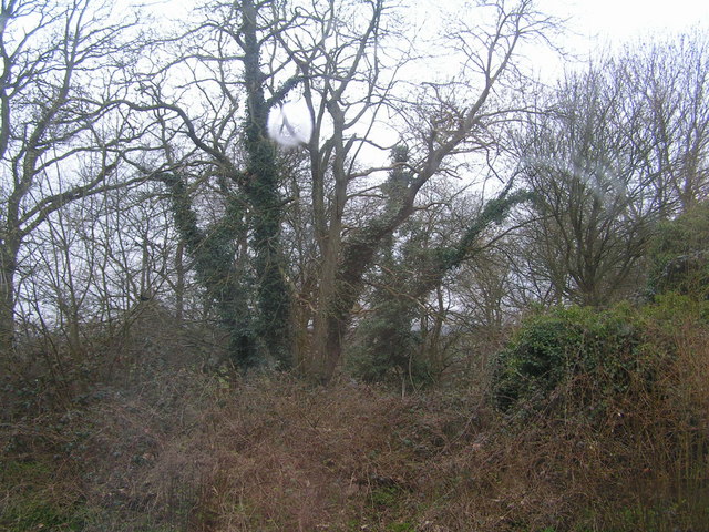
Peartree Wood is a picturesque woodland located in the county of Sussex, England. Nestled in the heart of the South Downs National Park, this enchanting forest covers an area of approximately 100 acres. It is renowned for its natural beauty, diverse wildlife, and tranquil atmosphere, making it a popular destination for nature lovers and outdoor enthusiasts.

The wood is primarily composed of a mixture of broadleaf and coniferous trees, including oak, beech, ash, and pine, which create a rich and varied landscape. The dense canopy formed by these trees provides shelter and habitat for a wide range of wildlife, including deer, foxes, badgers, and an abundance of bird species such as woodpeckers and owls.

Visitors to Peartree Wood can enjoy a network of well-maintained trails that meander through the forest, offering opportunities for leisurely walks, jogging, and cycling. The paths are surrounded by a carpet of wildflowers and ferns, adding a splash of color to the greenery. Along the way, there are several designated picnic areas where visitors can relax and take in the peaceful surroundings.

Peartree Wood also boasts a small pond, which serves as a watering hole for various species of amphibians and insects. The pond is a popular spot for nature enthusiasts to observe and learn about the diverse ecosystem that thrives within the wood.

Overall, Peartree Wood offers a tranquil escape from the hustle and bustle of everyday life, providing visitors with a chance to immerse themselves in the beauty of nature and explore the wonders of a quintessential Sussex woodland.

If you have any feedback on the listing, please let us know in the comments section below.

Peartree Wood Images

Images are sourced within 2km of 51.03497/0.35170856 or Grid Reference TQ6428. Thanks to Geograph Open Source API. All images are credited.

Stonegate Church Southern approach to Stonegate Village
Stonegate Church
Southern approach to Stonegate Village
Woods behind Stonegate station one of the many bits of woodland in the Weald
Woods behind Stonegate station
one of the many bits of woodland in the Weald
Newbridge Wood Oak "standards" over hornbeam and small-leaved lime coppice in this large ancient woodland.
Newbridge Wood
Oak "standards" over hornbeam and small-leaved lime coppice in this large ancient woodland.
Scrag Oak Oast, Snape Lane, Wadhurst
Stream Farmhouse, Brinker's Lane, Scrag Oak
Grey cat and bridleway The cat is speeding away down the tunnel of this track to Mabb's Hill Farm.
Grey cat and bridleway
The cat is speeding away down the tunnel of this track to Mabb's Hill Farm.
Footpath off Churchsettle Lane The path enters classic rolling, wooded Wealden countryside.
Footpath off Churchsettle Lane
The path enters classic rolling, wooded Wealden countryside.
Frozen pond off Churchsettle Lane Adjacent to the eponymous farm.
Frozen pond off Churchsettle Lane
Adjacent to the eponymous farm.
Sharp bend, Wealden cottage On Churchsettle Lane
Sharp bend, Wealden cottage
On Churchsettle Lane
View north of Pear Tree Hill Rough pasture in this corner of the Weald.
View north of Pear Tree Hill
Rough pasture in this corner of the Weald.
Stone Gate Church, Stonegate
Stonegate Station On the Hastings-Charing Cross line. Opened in 1846 as Witherenden after the nearby farm and mill the name was then changed to Ticehurst Road after the nearest reasonable sized village. It retained this name until 1946 when the station was renamed after the small settlement a mile up the road. Taken from the footbridge that links the two platforms.
Stonegate Station
On the Hastings-Charing Cross line. Opened in 1846 as Witherenden after the nearby farm and mill the name was then changed to Ticehurst Road after the nearest reasonable sized village. It retained this name until 1946 when the station was renamed after the small settlement a mile up the road. Taken from the footbridge that links the two platforms.
Station House, Stonegate The current ticket office is entered via the porch whilst the actual former station master's house is currently awaiting occupants.
Station House, Stonegate
The current ticket office is entered via the porch whilst the actual former station master's house is currently awaiting occupants.
Witherenden Farm Looking across the cornfield to the farmhouse. Taken from the footpath that links Station Road with Bardown Farm.
Witherenden Farm
Looking across the cornfield to the farmhouse. Taken from the footpath that links Station Road with Bardown Farm.
Going Underground A culvert taking a tributary under the Hastings-Tonbridge line, taken from the footpath that links Station Road with Bardown Farm.
Going Underground
A culvert taking a tributary under the Hastings-Tonbridge line, taken from the footpath that links Station Road with Bardown Farm.
Across the Tracks The footpath linking Station Road to Bardown Farm turns 90 degrees at this point to cross the Hastings-Tonbridge line.
Across the Tracks
The footpath linking Station Road to Bardown Farm turns 90 degrees at this point to cross the Hastings-Tonbridge line.
Small Ford, Hoadley Wood A small tributary of Tide Brook has its spring a little further up in the wood and crosses the footpath to Bardown Farm at this point before heading down to the right then turning south again.
Small Ford, Hoadley Wood
A small tributary of Tide Brook has its spring a little further up in the wood and crosses the footpath to Bardown Farm at this point before heading down to the right then turning south again.
Show me another place!

Peartree Wood is located at Grid Ref: TQ6428 (Lat: 51.03497, Lng: 0.35170856)

Administrative County: East Sussex

District: Wealden

Police Authority: Sussex

What 3 Words

///satin.baseline.stole. Near Wadhurst, East Sussex

Nearby Locations

Dens Wood Peartree Wood

Related Wikis

Shover's Green Baptist Chapel

Shover's Green Baptist Chapel is a former Strict Baptist place of worship in the hamlet of Shover's Green in East Sussex, England. Shover's Green is in...

Wadhurst Park

Wadhurst Park is a landed estate located in Wadhurst, East Sussex. It is owned by the Rausing family. The estate is 796 hectares and includes a deer park...

Stonegate railway station

Stonegate railway station (not to be confused with Stone Crossing) is on the Hastings line in the south of England. It is located between Witherenden Hill...

Uplands Academy

Uplands Academy (formerly Uplands Community College) is a coeducational secondary school and sixth form located in Wadhurst, East Sussex, England. ��2...

Nearby Amenities

Located within 500m of 51.03497,0.35170856
Maplesden
Is In: East Sussex, England, UK
Source: npe
Lat/Long: 51.0356326/0.3559329
The data included in this document is from www.openstreetmap.org. The data is made available under ODbL.

Have you been to Peartree Wood?

Leave your review of Peartree Wood below (or comments, questions and feedback).