Copstone Shaw

Wood, Forest in Sussex Wealden

England

Copstone Shaw

Foxhole Barn Oast, Foxhole Lane, Wadhurst, East Sussex Three round kiln oast house.
Foxhole Barn Oast, Foxhole Lane, Wadhurst, East Sussex Credit: Oast House Archive

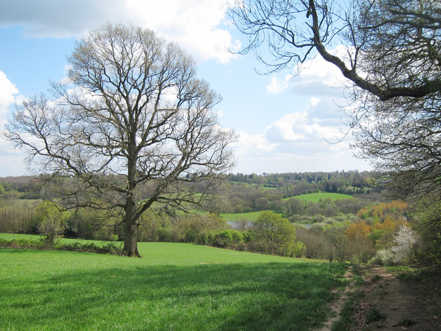
Copstone Shaw is a dense woodland located in Sussex, England. Covering an area of approximately 100 acres, it is known for its picturesque beauty and abundant wildlife. The woodland is predominantly made up of native broadleaf trees such as oak, beech, and ash, creating a rich and diverse ecosystem.

The forest floor is covered in lush vegetation, comprising of ferns, bluebells, and wild garlic, adding to the charm and natural beauty of the area. The dense canopy of the trees provides a perfect habitat for a wide range of bird species, including woodpeckers, tawny owls, and nuthatches. These birds can often be heard or spotted flitting between the branches.

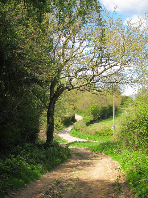
Several well-maintained footpaths crisscross the woodland, allowing visitors to explore the area at their own pace. These trails wind through the ancient woods, offering breathtaking views and opportunities for nature enthusiasts to spot various woodland creatures such as squirrels, foxes, and deer.

Copstone Shaw has a rich history, and there are remnants of an Iron Age hillfort within its boundaries. The area has also been used for timber production in the past, with evidence of old saw pits and charcoal burning platforms scattered throughout.

The woodland is managed by a local conservation trust, which ensures its preservation and protection for future generations. It serves as an important educational resource for schools and a popular destination for nature lovers and hikers looking to immerse themselves in the tranquility of the natural world.

If you have any feedback on the listing, please let us know in the comments section below.

Copstone Shaw Images

Images are sourced within 2km of 51.074173/0.34908473 or Grid Reference TQ6433. Thanks to Geograph Open Source API. All images are credited.

Foxhole Barn Oast, Foxhole Lane, Wadhurst, East Sussex Three round kiln oast house.
Foxhole Barn Oast, Foxhole Lane, Wadhurst, East Sussex
Three round kiln oast house.
Mill Oast, Washwell Lane, Wadhurst, East Sussex Single round kiln oast house, just off the centre of Wadhurst. Possibly not an original oast.
Mill Oast, Washwell Lane, Wadhurst, East Sussex
Single round kiln oast house, just off the centre of Wadhurst. Possibly not an original oast.
Mill Oast, Washwell Lane, Wadhurst, East Sussex Single round kiln oast house, just off the centre of Wadhurst. Possibly not an original oast.
Mill Oast, Washwell Lane, Wadhurst, East Sussex
Single round kiln oast house, just off the centre of Wadhurst. Possibly not an original oast.
Well kept garden Front garden of a semi detached house at number 2 Courthope Avenue, at junction with Washwell Lane.
Well kept garden
Front garden of a semi detached house at number 2 Courthope Avenue, at junction with Washwell Lane.
Washwell Lane Top of Washwell Lane heading into the centre of Wadhurst village. A new development is under construction to the left, on the site of demolished bungalow. Church of Peter and Paul seen in centre.
Washwell Lane
Top of Washwell Lane heading into the centre of Wadhurst village. A new development is under construction to the left, on the site of demolished bungalow. Church of Peter and Paul seen in centre.
New Development on Townsend Road Built on the site of a bungalow, demolished to make way for this terrace of houses.
New Development on Townsend Road
Built on the site of a bungalow, demolished to make way for this terrace of houses.
Sussex Border Path Sussex border path and public footpath between Bewl Water and approaching Cousley Wood Road, near to the Vine pub.
Sussex Border Path
Sussex border path and public footpath between Bewl Water and approaching Cousley Wood Road, near to the Vine pub.
Butts Lane Dead end lane to Little Butts Farm.
Butts Lane
Dead end lane to Little Butts Farm.
View to Bewl Water Reservoir Looking from the Sussex Border Path towards the reservoir. Little Butts Farm at the end of the field. The dam of the reservoir just seen to the left.
View to Bewl Water Reservoir
Looking from the Sussex Border Path towards the reservoir. Little Butts Farm at the end of the field. The dam of the reservoir just seen to the left.
Countryside around Bewl Water View from the Sussex Border Path, from Cousley Wood Road towards Bewl Water, which is just seen beyond the trees.
Countryside around Bewl Water
View from the Sussex Border Path, from Cousley Wood Road towards Bewl Water, which is just seen beyond the trees.
Sussex Border Path From Cousley Wood Road down to Bewl Water
Sussex Border Path
From Cousley Wood Road down to Bewl Water
Tree by the Sussex Border Path The Sussex Border Path is a footpath route nearly 150 miles long around the inland boundary of the county of Sussex. The county owes its origins to the kingdom of the South Saxons and can claim to have one of the longest inland county boundaries from Emsworth to Rye. The route was devised in 1983 and is well signed along most of the route. Website <span class="nowrap"><a title="http://www.sussexborderpath.co.uk/" rel="nofollow ugc noopener" href="http://www.sussexborderpath.co.uk/">Link</a><img style="margin-left:2px;" alt="External link" title="External link - shift click to open in new window" src="https://s1.geograph.org.uk/img/external.png" width="10" height="10"/></span> 
Map: <a title="https://www.geograph.org.uk/search.php?i=40140109&page=1&displayclass=map#i=40140109&page=1&displayclass=map&zoom=2&lat=51.03263&lon=-0.05427&layers=FTTB00000000000T" href="https://www.geograph.org.uk/search.php?i=40140109&page=1&displayclass=map#i=40140109&page=1&displayclass=map&zoom=2&lat=51.03263&lon=-0.05427&layers=FTTB00000000000T">Link</a>
Tree by the Sussex Border Path
The Sussex Border Path is a footpath route nearly 150 miles long around the inland boundary of the county of Sussex. The county owes its origins to the kingdom of the South Saxons and can claim to have one of the longest inland county boundaries from Emsworth to Rye. The route was devised in 1983 and is well signed along most of the route. Website LinkExternal link Map: Link
Yodel Van on Courthope Avenue Washwell Lane to left.
Yodel Van on Courthope Avenue
Washwell Lane to left.
Wadhurst high street
Mill Oast Single round kiln oast house, just off the centre of Wadhurst. Possibly not an original oast.
Mill Oast
Single round kiln oast house, just off the centre of Wadhurst. Possibly not an original oast.
St Peter and Saint Paul church, Wadhurst The church has a tall spire of 124 feet. This broach spire is slightly out of true, and dates from 14th C. There are over 5000 shingles. Tower is 12th C. Nave and aisles 13th and 14th C. The porch has a parvise over from 15th C. 
The church contains over 30 iron memorial slabs, mostly 17th C. as this area had a large Iron industry from the 16th to the 19th Century.
St Peter and Saint Paul church, Wadhurst
The church has a tall spire of 124 feet. This broach spire is slightly out of true, and dates from 14th C. There are over 5000 shingles. Tower is 12th C. Nave and aisles 13th and 14th C. The porch has a parvise over from 15th C. The church contains over 30 iron memorial slabs, mostly 17th C. as this area had a large Iron industry from the 16th to the 19th Century.
Land near Pell Bridge, near Wadhurst
Blacksmith's Lane near Wadhurst
Show me another place!

Copstone Shaw is located at Grid Ref: TQ6433 (Lat: 51.074173, Lng: 0.34908473)

Administrative County: East Sussex

District: Wealden

Police Authority: Sussex

What 3 Words

///wished.claw.reinstate. Near Wadhurst, East Sussex

Related Wikis

Rehoboth Chapel, Pell Green

Rehoboth Chapel is a former Strict Baptist place of worship in the hamlet of Pell Green in East Sussex, England. Pell Green is in the parish of Wadhurst...

Wadhurst

Wadhurst is a market town in East Sussex, England. It is the centre of the civil parish of Wadhurst, which also includes the hamlets of Cousley Wood and...

Uplands Academy

Uplands Academy (formerly Uplands Community College) is a coeducational secondary school and sixth form located in Wadhurst, East Sussex, England. ��2...
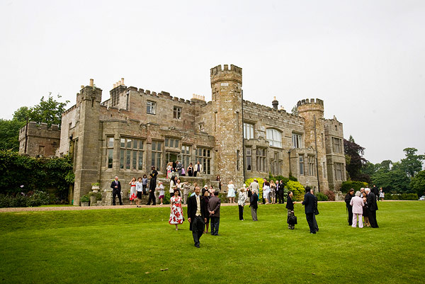
Wadhurst Castle

Wadhurst Castle is a 19th-century castellated mansion just to the west of the town of Wadhurst, East Sussex, England, in an elevated position overlooking...

Wadhurst railway station

Wadhurst railway station is on the Hastings line in the south of England and serves the town of Wadhurst, East Sussex. It is 39 miles 23 chains (63.2 km...

Bewl Bridge Rowing Club

Bewl Bridge Rowing Club is a rowing club on the Bewl Water, based at Bewlbridge Lane, Lamberhurst, Wadhurst, Tunbridge Wells. Rowers aged 12 and upwards...

Shover's Green Baptist Chapel

Shover's Green Baptist Chapel is a former Strict Baptist place of worship in the hamlet of Shover's Green in East Sussex, England. Shover's Green is in...
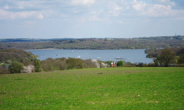
Bewl Water

Bewl Water is a reservoir in the valley of the River Bewl, straddling the boundary between Kent and East Sussex in England. It is about 2 miles (3.2 km...

Nearby Amenities

Located within 500m of 51.074173,0.34908473
Barrier: stile
Lat/Long: 51.0759888/0.34382
Barrier: stile
Lat/Long: 51.075771/0.3461117
Barrier: kissing_gate
Lat/Long: 51.074523/0.3490342
Pub
The Old Vine
Addr City: Wadhurst
Addr Postcode: TN5 6ER
Addr Street: Cousley Wood Road
Fhrs Id: 182499
Source Addr: FHRS Open Data
Wikidata: Q26636544
Lat/Long: 51.0759252/0.3554914
Cousley Wood
Place: hamlet
Lat/Long: 51.0762714/0.3544272
Post Box
Operator: Royal Mail
Operator Wikidata: Q638098
Post Box Type: lamp
Ref: TN5 139D
Royal Cypher: EIIR
Royal Cypher Wikidata: Q33102113
Lat/Long: 51.0736738/0.3472088
SDR Autos
Brand: Alfa Romeo
Brand Wikidata: Q26921
Shop: car
Lat/Long: 51.075817/0.3547677
Pell Green
Place: locality
Source: OS_OpenData_StreetView
Lat/Long: 51.0730144/0.3476143
The data included in this document is from www.openstreetmap.org. The data is made available under ODbL.

Have you been to Copstone Shaw?

Leave your review of Copstone Shaw below (or comments, questions and feedback).