Hogg Wood

Wood, Forest in Kent Tunbridge Wells

England

Hogg Wood

Foxhole Lane Leaving the junction with Romford Road and Bramble Reed Lane.
Foxhole Lane Credit: Robin Webster

Hogg Wood is a beautiful forest located in Kent, England. Covering an area of approximately 150 acres, this woodland is a haven for nature lovers and outdoor enthusiasts alike. Hogg Wood is situated near the village of Westerham, just a short drive from London, making it easily accessible for day trips or weekend getaways.

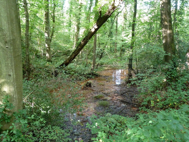
The forest is predominantly composed of broadleaf trees, such as oak, beech, and birch, which create a stunning canopy that provides shade and shelter to a diverse range of flora and fauna. The woodland floor is carpeted with bluebells during the springtime, creating a breathtaking scene of vibrant colors and fragrant aromas.

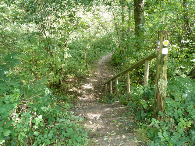
Hogg Wood offers a variety of walking trails and paths, allowing visitors to explore the forest at their own pace. These trails are well-maintained and clearly marked, making it easy for hikers of all levels to navigate through the woodland. Along the way, visitors may come across charming wooden bridges that cross over babbling brooks, adding to the picturesque ambiance of the forest.

The forest is also home to a wide range of wildlife, including deer, foxes, and various species of birds. Birdwatchers will delight in the opportunity to spot woodpeckers, owls, and other feathered creatures that call Hogg Wood their home.

For those seeking a tranquil escape from the hustle and bustle of city life, Hogg Wood provides the perfect setting. With its natural beauty and peaceful atmosphere, this forest is a true gem in the heart of Kent.

If you have any feedback on the listing, please let us know in the comments section below.

Hogg Wood Images

Images are sourced within 2km of 51.168439/0.347993 or Grid Reference TQ6443. Thanks to Geograph Open Source API. All images are credited.

Foxhole Lane Leaving the junction with Romford Road and Bramble Reed Lane.
Foxhole Lane
Leaving the junction with Romford Road and Bramble Reed Lane.
Romford Road Leaving the junction with Foxhole Lane and Bramble Reed Lane.
Romford Road
Leaving the junction with Foxhole Lane and Bramble Reed Lane.
Well in Snipe Wood At a guess, there is another installation nearby which is definitely a well.
Well in Snipe Wood
At a guess, there is another installation nearby which is definitely a well.
Bassetts Boreholes A South East Water  groundwater extraction site.
Bassetts Boreholes
A South East Water groundwater extraction site.
Footpath WT226, Pembury, in Snipe Wood Passing through chestnut coppice.
Footpath WT226, Pembury, in Snipe Wood
Passing through chestnut coppice.
Comma butterfly on Bracken In Snipe Wood.
Comma butterfly on Bracken
In Snipe Wood.
Path over former pond bay There was once a pond on the other side, which disappeared from maps in late Victorian times.  Presumably there was once a sluice on the other side, but no remains caught my eye.  The stream is a tributary of Tudeley Brook, the path is WT226 Pembury.
Path over former pond bay
There was once a pond on the other side, which disappeared from maps in late Victorian times. Presumably there was once a sluice on the other side, but no remains caught my eye. The stream is a tributary of Tudeley Brook, the path is WT226 Pembury.
Path, woodland west of Snipe Wood I think this was formerly an orchard. The path takes the place of footpath WT222 Pembury, which is mapped as a parallel route about 70 m north-east, and may be disused.
Path, woodland west of Snipe Wood
I think this was formerly an orchard. The path takes the place of footpath WT222 Pembury, which is mapped as a parallel route about 70 m north-east, and may be disused.
Path through abandoned orchard near Pembury The path takes the place of footpath WT222 Pembury, which is mapped as a parallel route about 70 m north-east, and may be disused.
Path through abandoned orchard near Pembury
The path takes the place of footpath WT222 Pembury, which is mapped as a parallel route about 70 m north-east, and may be disused.
Steps on footpath WT222, Pembury Descending to a stream crossing.
Steps on footpath WT222, Pembury
Descending to a stream crossing.
Narrow footbridge on footpath WT222, Pembury
Swamp below  footpath WT222, Pembury
Swamp below footpath WT222, Pembury
Footpath WT222, Pembury, in Snipe Wood
Tudeley Brook, Crittenden Road near Colt's Hill The upstream face of the road bridge.
Tudeley Brook, Crittenden Road near Colt's Hill
The upstream face of the road bridge.
Church Spire at Kent College
Pippin's fruit farm. This farm grows a variety of fruit (apples, pears, plums, cherries, strawberries, etc). PYO is popular and there is a farm shop. The farm has one orchard set aside to growing over 20 varieties of apples.
Pippin's fruit farm.
This farm grows a variety of fruit (apples, pears, plums, cherries, strawberries, etc). PYO is popular and there is a farm shop. The farm has one orchard set aside to growing over 20 varieties of apples.
Orchards, Pippins Farm, Pembury. This is an apple orchard.
Orchards, Pippins Farm, Pembury.
This is an apple orchard.
Downingbury Farm, Pembury. A PYO fruit farm on the edge of Pembury, growing a variety of fruit.
Downingbury Farm, Pembury.
A PYO fruit farm on the edge of Pembury, growing a variety of fruit.
Show me another place!

Hogg Wood is located at Grid Ref: TQ6443 (Lat: 51.168439, Lng: 0.347993)

Administrative County: Kent

District: Tunbridge Wells

Police Authority: Kent

What 3 Words

///harmless.flick.chin. Near Five Oak Green, Kent

Nearby Locations

Hogg Wood Lord's Wood

Related Wikis

Church of St Thomas à Becket, Capel

The Church of St Thomas à Becket is a redundant Anglican church in the village of Capel, Kent, England. It is recorded in the National Heritage List for...

Capel, Kent

Capel is a hamlet and civil parish in the borough of Tunbridge Wells in Kent, England. The parish is located on the north of the Weald, 3 miles (4.8 km...

Kent College, Pembury

Kent College is an independent day and boarding school from 3-18. Forest Explorers Nursery is for girls and boys from rising 3 years, boys can join Reception...

Brenchley Wood

Brenchley Wood is a 15-hectare (37-acre) nature reserve south of Paddock Wood in Kent. It is managed by the Kent Wildlife Trust, and it is part of the...

Nearby Amenities

Located within 500m of 51.168439,0.347993
Power: tower
Lat/Long: 51.1676376/0.3436593
Power: tower
Lat/Long: 51.1682405/0.3432241
Power: pole
Lat/Long: 51.1692146/0.3501941
Power: tower
Lat/Long: 51.1689114/0.3481116
Power: pole
Lat/Long: 51.1696298/0.3545562
Power: pole
Lat/Long: 51.1691482/0.3502369
Power: pole
Lat/Long: 51.1695236/0.3514495
Power: pole
Lat/Long: 51.1689368/0.3490587
Power: pole
Lat/Long: 51.1697103/0.3545123
Power: pole
Lat/Long: 51.1688957/0.3491867
Power: pole
Lat/Long: 51.1694426/0.3514336
Power: tower
Lat/Long: 51.1706268/0.3538851
Power: tower
Lat/Long: 51.1696042/0.350389
Power: pole
Lat/Long: 51.1698653/0.3437653
Power: pole
Lat/Long: 51.1684818/0.3438041
Power: pole
Lat/Long: 51.1698889/0.3461046
Power: pole
Lat/Long: 51.1685706/0.3436867
Power: pole
Lat/Long: 51.1699912/0.3460784
Power: pole
Lat/Long: 51.1687146/0.343584
Power: pole
Lat/Long: 51.1705625/0.3438861
Power: pole
Lat/Long: 51.169294/0.3451981
Power: pole
Lat/Long: 51.1698173/0.3438982
Power: pole
Lat/Long: 51.1684098/0.3438746
Power: pole
Lat/Long: 51.170445/0.344009
Power: pole
Lat/Long: 51.1693458/0.3450953
Power: pole
Lat/Long: 51.1710905/0.3479467
Power: pole
Lat/Long: 51.1722154/0.3492227
Power: pole
Lat/Long: 51.1705319/0.3469248
Power: pole
Lat/Long: 51.1710458/0.3440928
Power: pole
Lat/Long: 51.1721739/0.3441416
Power: pole
Lat/Long: 51.1717622/0.3489186
Power: pole
Lat/Long: 51.1718034/0.3488144
Power: pole
Lat/Long: 51.1721627/0.3442708
Power: pole
Lat/Long: 51.170493/0.3470356
Power: pole
Lat/Long: 51.1711453/0.3478512
Power: pole
Lat/Long: 51.1712268/0.3439898
Power: transformer
Lat/Long: 51.1678506/0.3436741
Power: transformer
Lat/Long: 51.1679078/0.343886
The data included in this document is from www.openstreetmap.org. The data is made available under ODbL.

Have you been to Hogg Wood?

Leave your review of Hogg Wood below (or comments, questions and feedback).