Fen Street

Settlement in Norfolk South Norfolk

England

Fen Street

Welcome Centre at Lopham Fen
Welcome Centre at Lopham Fen Credit: Dave Thompson

Fen Street is a charming village located in the county of Norfolk, England. Situated in the heart of the picturesque Norfolk Broads, this small community is surrounded by beautiful natural landscapes and offers a peaceful and idyllic setting.

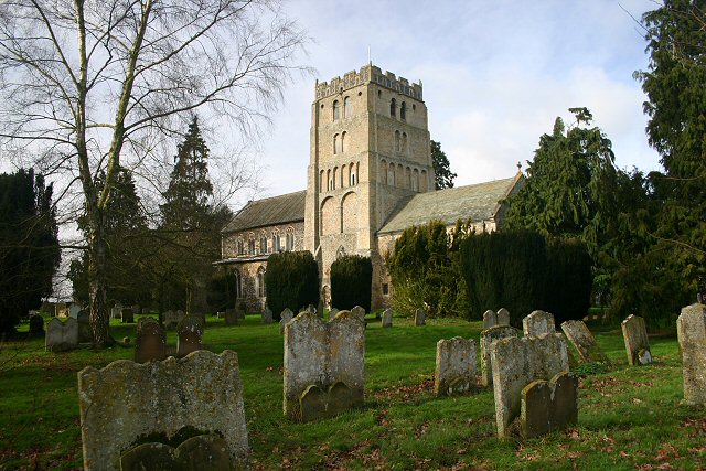
The village of Fen Street is known for its rich history, dating back several centuries. It has retained its traditional character, with many of its buildings constructed in the classic Norfolk architectural style. The village church, St. Mary's, is a prominent landmark and showcases stunning medieval craftsmanship.

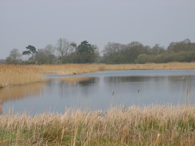
Nature lovers will be delighted by the abundance of wildlife and scenic views in Fen Street. The village is nestled among vast expanses of marshland, reed beds, and open water, providing a haven for a wide variety of bird species, such as marsh harriers and bitterns. Visitors can enjoy walking along the numerous footpaths that crisscross the area, taking in the tranquil atmosphere and breathtaking vistas.

Despite its peaceful ambiance, Fen Street offers convenient amenities for residents and visitors alike. There are a few local shops and a welcoming village pub, where one can enjoy a pint of locally brewed ale and sample traditional Norfolk dishes.

Fen Street's location within the Norfolk Broads also makes it a popular destination for boating enthusiasts. The village has a small marina where visitors can rent boats or join guided tours to explore the waterways, discovering hidden gems along the rivers and broads.

Overall, Fen Street offers a serene retreat for those seeking a quintessential Norfolk experience, with its beautiful surroundings, historical charm, and ample opportunities to connect with nature.

If you have any feedback on the listing, please let us know in the comments section below.

Fen Street Images

Images are sourced within 2km of 52.386158/1.036001 or Grid Reference TM0680. Thanks to Geograph Open Source API. All images are credited.

Welcome Centre at Lopham Fen
Path through Lang Fen
'The Doll' at Bressingham, 1969 Bought for the opening in 1966 of the Nursery Railway, it was over gauge for the ex-Welsh quarry track and an ex-quarry locomotive hastily procured in its stead. Some sources state that it was sold on in 1968, whether true or not it was still here in early 1969. It is now at the Leighton Buzzard Light Railway, renamed just 'Doll', for no obvious reason. An Andrew Barclay product of 1919, works number 1641.
'The Doll' at Bressingham, 1969
Bought for the opening in 1966 of the Nursery Railway, it was over gauge for the ex-Welsh quarry track and an ex-quarry locomotive hastily procured in its stead. Some sources state that it was sold on in 1968, whether true or not it was still here in early 1969. It is now at the Leighton Buzzard Light Railway, renamed just 'Doll', for no obvious reason. An Andrew Barclay product of 1919, works number 1641.
'Gwynedd' on the Nursery Railway, Bressingham, 1969 Locomotive and track from the Penrhyn quarries, a source for many of the narrow gauge locomotives to be seen on tourist and heritage lines nowadays. Hunslet works number 316 of 1883.
'Gwynedd' on the Nursery Railway, Bressingham, 1969
Locomotive and track from the Penrhyn quarries, a source for many of the narrow gauge locomotives to be seen on tourist and heritage lines nowadays. Hunslet works number 316 of 1883.
Beckton Gasworks no. 25 at Bressingham, 1969 Neilson & Co, works No 6087 of 1896. In steam on the short length of standard gauge track then built, although then it extended further north than it does now.
Beckton Gasworks no. 25 at Bressingham, 1969
Neilson & Co, works No 6087 of 1896. In steam on the short length of standard gauge track then built, although then it extended further north than it does now.
Diss Road, Pooley Street
Lych Gate at St John the Baptist Church, Bressingham
St John the Baptist Church, Bressingham
Blue Pump Farm, Bressingham The sign and rock have arrived since last September
Blue Pump Farm, Bressingham
The sign and rock have arrived since last September
Low Road, Bressingham
Bressingham Gardens
Bressingham Gardens
Bressingham Trig Pillar Flush bracket S1952.
Bressingham Trig Pillar
Flush bracket S1952.
Postbox at Bressingham IP22 85. Royal Mail list this box as 'IP22 School Road Bressingham'.
Postbox at Bressingham
IP22 85. Royal Mail list this box as 'IP22 School Road Bressingham'.
Bressingham Hall <span class="nowrap"><a title="https://historicengland.org.uk/listing/the-list/list-entry/1049648?section=official-list-entry" rel="nofollow ugc noopener" href="https://historicengland.org.uk/listing/the-list/list-entry/1049648?section=official-list-entry">Link</a><img style="margin-left:2px;" alt="External link" title="External link - shift click to open in new window" src="https://s1.geograph.org.uk/img/external.png" width="10" height="10"/></span>
Bressingham Hall
Roundabout at Bressingham Gardens and Steam Museum
Low Road, by Ling Farm
Cottage at the junction of Slade Lane with Low Road
Show me another place!

Fen Street is located at Grid Ref: TM0680 (Lat: 52.386158, Lng: 1.036001)

Administrative County: Norfolk

District: South Norfolk

Police Authority: Norfolk

What 3 Words

///feels.lays.catchers. Near Diss, Norfolk

Related Wikis

Bressingham

Bressingham is a village and civil parish in the English county of Norfolk. It covers an area of 15.77 km2 (6.09 sq mi) and had a population of 751 in...

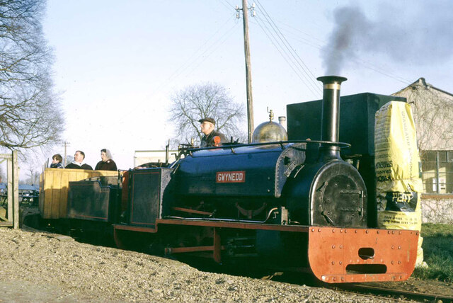
Bressingham Steam and Gardens

Bressingham Steam & Gardens is a steam museum and gardens located at Bressingham (adjacent to a garden centre), west of Diss in Norfolk, England. The site...

Redgrave and Lopham Fens

Redgrave and Lopham Fens is a 127 hectare biological Site of Special Scientific Interest between Thelnetham in Suffolk and Diss in Norfolk. It is a national...

Fersfield

Fersfield is a village and former civil parish, now in the parish of Bressingham, in the South Norfolk district, in the county of Norfolk, England. The...

South Lopham

South Lopham is a village and civil parish in the English county of Norfolk. It covers an area of 7.91 km2 (3.05 sq mi) and had a population of 371 in...

St Mary's Church, Wortham

St Mary's Church is the parish church of Wortham in Suffolk, England, and in the Diocese of St Edmundsbury and Ipswich. It is a round-tower church; the...

St Mary's Church, Redgrave

St Mary's Church is the redundant Church of England parish church of the village of Redgrave, Suffolk, England. It is a Grade I listed building. and is...

Boyland Common

Boyland Common is a place in the English county of Norfolk. It lies on the border of Fersfield and Shelfanger parishes. It consists of a few scattered...

Nearby Amenities

Located within 500m of 52.386158,1.036001
Power: pole
Source: Bing
Lat/Long: 52.3892696/1.0403967
Power: pole
Source: Bing
Lat/Long: 52.3882678/1.040917
Power: pole
Source: Bing
Lat/Long: 52.3867487/1.0416841
Parking
Parking: layby
Source: Bing
Lat/Long: 52.3874596/1.0306784
White House Bed & Breakfast
Addr Postcode: IP22 2AG
Addr Street: Low Road
Fhrs Id: 647543
Tourism: guest_house
Url: http://www.whitehousebressingham.co.uk/
Lat/Long: 52.3871517/1.0352994
Location Transition: yes
Power: pole
Lat/Long: 52.3885247/1.0379747
Power: pole
Lat/Long: 52.3882614/1.0374966
Power: pole
Lat/Long: 52.387956/1.0369625
Power: pole
Lat/Long: 52.3876224/1.0363656
Location Transition: yes
Power: pole
Lat/Long: 52.3873929/1.0359294
Power: pole
Lat/Long: 52.3866026/1.0431013
Power: pole
Lat/Long: 52.3858541/1.0421865
Location Transition: yes
Power: pole
Lat/Long: 52.3873484/1.035917
Power: pole
Lat/Long: 52.3862134/1.0390526
Power: pole
Lat/Long: 52.3860306/1.0429434
Power: pole
Lat/Long: 52.386436/1.04196
Power: pole
Lat/Long: 52.3863332/1.0405168
Power: pole
Lat/Long: 52.3861076/1.0377199
Power: pole
Lat/Long: 52.3860115/1.0363577
Power: pole
Lat/Long: 52.3868563/1.0360849
Power: pole
Lat/Long: 52.385919/1.0349836
Power: pole
Lat/Long: 52.385816/1.0293008
Power: pole
Lat/Long: 52.3857741/1.0306175
Power: pole
Lat/Long: 52.3858487/1.0321952
Power: pole
Lat/Long: 52.385881/1.0329023
Power: pole
Lat/Long: 52.3858921/1.0336027
Power: pole
Lat/Long: 52.3858568/1.0343296
Addr Housename: The Mill House
Addr Street: Low Road
Building: house
Lat/Long: 52.3872753/1.0349067
The data included in this document is from www.openstreetmap.org. The data is made available under ODbL.

Have you been to Fen Street?

Leave your review of Fen Street below (or comments, questions and feedback).