Clay Wood

Wood, Forest in Sussex Wealden

England

Clay Wood

Hop Garden near Witherenden An uncommon sight these days, one of the few hop gardens in an area in the High Weald that used to be famous for hop growing.  This is in early spring when the trellis has been strung, and the fresh bines are just emerging.
Hop Garden near Witherenden Credit: David Saunders

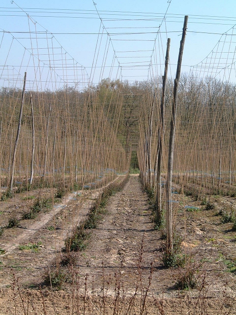
Clay Wood is a picturesque forest located in Sussex, England. Covering an area of approximately 50 acres, this woodland is known for its rich biodiversity and natural beauty. The wood is predominantly made up of clay soil, hence its name, which contributes to its unique ecosystem.

The diverse range of tree species found in Clay Wood includes oak, beech, ash, and silver birch. These towering trees create a dense canopy, providing shade and shelter for a variety of flora and fauna. Bluebells, primroses, and wild garlic carpet the forest floor during the spring, creating a stunning display of colors.

The wood is crisscrossed by a network of well-maintained footpaths, inviting visitors to explore its tranquil surroundings. Walking through Clay Wood, one can encounter various wildlife species, including deer, foxes, badgers, and a multitude of bird species. The area is particularly popular among birdwatchers, as sightings of woodpeckers, owls, and buzzards are common.

Clay Wood is not only a haven for nature enthusiasts but also serves as an important educational resource. Local schools and nature organizations often organize field trips to the wood, offering children the opportunity to learn about the natural environment and its conservation.

Managed by the Sussex Wildlife Trust, Clay Wood is carefully preserved, ensuring the protection of its unique ecosystem. The trust also organizes guided walks and events throughout the year, allowing visitors to gain deeper insights into the forest's natural history and ecological significance.

Overall, Clay Wood stands as a remarkable example of the natural beauty and biodiversity that Sussex has to offer.

If you have any feedback on the listing, please let us know in the comments section below.

Clay Wood Images

Images are sourced within 2km of 51.019898/0.3318952 or Grid Reference TQ6327. Thanks to Geograph Open Source API. All images are credited.

Hop Garden near Witherenden An uncommon sight these days, one of the few hop gardens in an area in the High Weald that used to be famous for hop growing.  This is in early spring when the trellis has been strung, and the fresh bines are just emerging.
Hop Garden near Witherenden
An uncommon sight these days, one of the few hop gardens in an area in the High Weald that used to be famous for hop growing. This is in early spring when the trellis has been strung, and the fresh bines are just emerging.
Oil seed rape crop in flower A High Weald landscape in spring, near Witherenden Hill
Oil seed rape crop in flower
A High Weald landscape in spring, near Witherenden Hill
Batts Wood View westwards to Batts Wood and Clay Wood across an arable field.
Batts Wood
View westwards to Batts Wood and Clay Wood across an arable field.
Newbridge Wood Boundary trees perched on an exposed sandstone outcrop on the south west corner of Newbridge Wood
Newbridge Wood
Boundary trees perched on an exposed sandstone outcrop on the south west corner of Newbridge Wood
Bines Farm Bines Farm from Bivelham Forge Farm looking over the River Rother
Bines Farm
Bines Farm from Bivelham Forge Farm looking over the River Rother
Newbridge Wood Oak "standards" over hornbeam and small-leaved lime coppice in this large ancient woodland.
Newbridge Wood
Oak "standards" over hornbeam and small-leaved lime coppice in this large ancient woodland.
Sharp bend, Wealden cottage On Churchsettle Lane
Sharp bend, Wealden cottage
On Churchsettle Lane
Oak by Turk's Bridge In the flat valley bottom of the Rother.
Oak by Turk's Bridge
In the flat valley bottom of the Rother.
View east from Fair Oak Farm Bedlam Wood on the left.
View east from Fair Oak Farm
Bedlam Wood on the left.
River Rother flowing east at Witherenden Bridge
View west from entrance to Fair Oak Farm See <span class="nowrap"><a title="http://www.fairoakfarm.co.uk/family-holiday-uk.htm" rel="nofollow ugc noopener" href="http://www.fairoakfarm.co.uk/family-holiday-uk.htm">Link</a><img style="margin-left:2px;" alt="External link" title="External link - shift click to open in new window" src="https://s1.geograph.org.uk/img/external.png" width="10" height="10"/></span> for information about the area, provided by the farm which has self catering accommodation.
View west from entrance to Fair Oak Farm
See LinkExternal link for information about the area, provided by the farm which has self catering accommodation.
Fair Oak Farm Barn Visit <span class="nowrap"><a title="www.fairoakfarm.co.uk" rel="nofollow ugc noopener" href="http://www.fairoakfarm.co.uk">Link</a><img style="margin-left:2px;" alt="External link" title="External link - shift click to open in new window" src="https://s1.geograph.org.uk/img/external.png" width="10" height="10"/></span> for more information about staying in self catering accommodation
Fair Oak Farm Barn
Visit LinkExternal link for more information about staying in self catering accommodation
Fair Oak Farm Oast Visit <span class="nowrap"><a title="www.fairoakfarm.co.uk" rel="nofollow ugc noopener" href="http://www.fairoakfarm.co.uk">Link</a><img style="margin-left:2px;" alt="External link" title="External link - shift click to open in new window" src="https://s1.geograph.org.uk/img/external.png" width="10" height="10"/></span> for more information
Fair Oak Farm Oast
Visit LinkExternal link for more information
Fair Oak Farm - Farmhouse <span class="nowrap"><a title="www.fairoakfarm.co.uk" rel="nofollow ugc noopener" href="http://www.fairoakfarm.co.uk">Link</a><img style="margin-left:2px;" alt="External link" title="External link - shift click to open in new window" src="https://s1.geograph.org.uk/img/external.png" width="10" height="10"/></span>
Fair Oak Farm - Farmhouse
Combe Manor Taken from the footpath on the way from Combe Wood towards Wadhurst Lake.
Combe Manor
Taken from the footpath on the way from Combe Wood towards Wadhurst Lake.
House on the edge of Batts Wood There is a footpath diversion post here, which diverts the footpath left up through the wood.
House on the edge of Batts Wood
There is a footpath diversion post here, which diverts the footpath left up through the wood.
Sheep watering hole Thirsty sheep taking a drink at a pond between Combe Farm and Wadhurst Park.
Sheep watering hole
Thirsty sheep taking a drink at a pond between Combe Farm and Wadhurst Park.
Footpath entrance on the edge of  Batts Wood The footpath is enclosed at this point by a deer proof fence and runs around the perimeter of Batts Wood. The photograph was taken looking back to the entrance where a notice warns walkers, entering Wadhurst Park, to keep to the footpath because of rutting stags. Wadhurst Lake can be seen in the distance.
Footpath entrance on the edge of Batts Wood
The footpath is enclosed at this point by a deer proof fence and runs around the perimeter of Batts Wood. The photograph was taken looking back to the entrance where a notice warns walkers, entering Wadhurst Park, to keep to the footpath because of rutting stags. Wadhurst Lake can be seen in the distance.
Show me another place!

Clay Wood is located at Grid Ref: TQ6327 (Lat: 51.019898, Lng: 0.3318952)

Administrative County: East Sussex

District: Wealden

Police Authority: Sussex

What 3 Words

///punctured.nametag.stared. Near Burwash, East Sussex

Related Wikis

Wadhurst Park

Wadhurst Park is a landed estate located in Wadhurst, East Sussex. It is owned by the Rausing family. The estate is 796 hectares and includes a deer park...

Holmshurst Manor

Holmshurst Manor is a Jacobean country house near Burwash in East Sussex, England. In 1970 it was purchased by Roger Daltrey of The Who. == Description... ==

Stonegate railway station

Stonegate railway station (not to be confused with Stone Crossing) is on the Hastings line in the south of England. It is located between Witherenden Hill...

Tidebrook

Tidebrook is a hamlet within the parish of Wadhurst in East Sussex, England. It is located between the villages of Mayfield and Wadhurst. The brook for...

Shover's Green Baptist Chapel

Shover's Green Baptist Chapel is a former Strict Baptist place of worship in the hamlet of Shover's Green in East Sussex, England. Shover's Green is in...

Paines Cross Meadow

Paines Cross Meadow is a 3.7-hectare (9.1-acre) biological Site of Special Scientific Interest north-east of Heathfield in East Sussex.This site is damp...

Uplands Academy

Uplands Academy (formerly Uplands Community College) is a coeducational secondary school and sixth form located in Wadhurst, East Sussex, England. ��2...

Burwash

Burwash, archaically known as Burghersh, is a rural village and civil parish in the Rother district of East Sussex, England. Situated in the High Weald...

Nearby Amenities

Located within 500m of 51.019898,0.3318952
The data included in this document is from www.openstreetmap.org. The data is made available under ODbL.

Have you been to Clay Wood?

Leave your review of Clay Wood below (or comments, questions and feedback).