Birching Shaw

Wood, Forest in Sussex Wealden

England

Birching Shaw

The King's Church, Heathfield This building on Station Road was originally the "Recreation Hall" but is now used as an evangelical church.  Church website: <span class="nowrap"><a title="http://www.kcheathfield.org.uk/" rel="nofollow ugc noopener" href="http://www.kcheathfield.org.uk/">Link</a><img style="margin-left:2px;" alt="External link" title="External link - shift click to open in new window" src="https://s1.geograph.org.uk/img/external.png" width="10" height="10"/></span>
The King's Church, Heathfield Credit: Stephen Craven

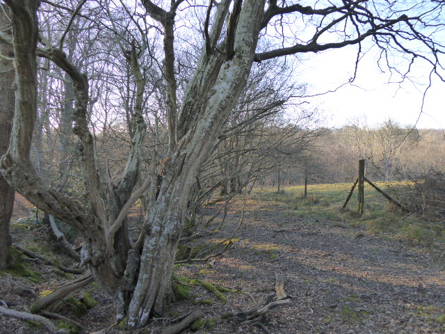
Birching Shaw is a picturesque woodland area located in Sussex, England. Situated within the enchanting South Downs National Park, this forested haven spans an approximate area of 200 acres. The name "Birching Shaw" is derived from the presence of birch trees, which dominate the landscape and provide a unique character to the area.

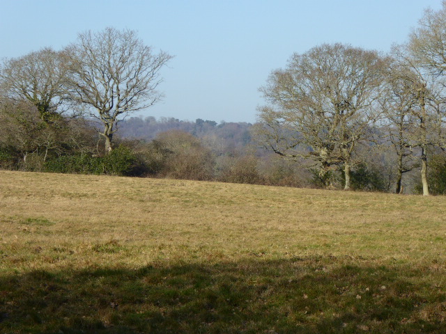
As one wanders through the woodland, they are greeted by a diverse range of plant and animal life, offering an immersive experience in nature. The forest floor is adorned with a rich carpet of mosses, ferns, and wildflowers, creating a vibrant and ever-changing tapestry throughout the seasons. The air is filled with the soothing sounds of chirping birds, rustling leaves, and the occasional scurrying of small mammals.

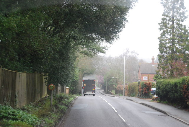
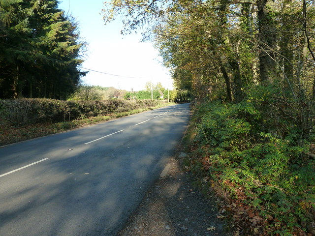
Birching Shaw is a popular destination for nature enthusiasts, hikers, and photographers, offering numerous trails and paths that wind their way through the forest. These trails provide stunning vistas of the surrounding countryside and offer glimpses of the local wildlife, such as deer, foxes, and various bird species.

The forest is also home to a variety of tree species, including oak, beech, and hazel, which provide a vital habitat for many woodland creatures. The dense foliage and towering trees create a tranquil and secluded atmosphere, making it an ideal location for those seeking solace in nature.

Overall, Birching Shaw, Sussex, is a mesmerizing woodland retreat that showcases the beauty and serenity of the English countryside. Its diverse flora and fauna, coupled with its tranquil ambiance, make it a must-visit destination for nature lovers and those seeking a respite from the hectic pace of modern life.

If you have any feedback on the listing, please let us know in the comments section below.

Birching Shaw Images

Images are sourced within 2km of 50.957751/0.24613201 or Grid Reference TQ5719. Thanks to Geograph Open Source API. All images are credited.

The King's Church, Heathfield This building on Station Road was originally the "Recreation Hall" but is now used as an evangelical church.  Church website: <span class="nowrap"><a title="http://www.kcheathfield.org.uk/" rel="nofollow ugc noopener" href="http://www.kcheathfield.org.uk/">Link</a><img style="margin-left:2px;" alt="External link" title="External link - shift click to open in new window" src="https://s1.geograph.org.uk/img/external.png" width="10" height="10"/></span>
The King's Church, Heathfield
This building on Station Road was originally the "Recreation Hall" but is now used as an evangelical church. Church website: LinkExternal link
Date stone of the Recreation Hall The date stone (1909) of a public hall on Station Road, Heathfield that is now used as a church- see <a href="https://www.geograph.org.uk/photo/2382607">TQ5821 : The King's Church, Heathfield</a> for context.
Date stone of the Recreation Hall
The date stone (1909) of a public hall on Station Road, Heathfield that is now used as a church- see TQ5821 : The King's Church, Heathfield for context.
A267 near Heathfield The A267 road is a 21 mile long road from Tunbridge Wells <a href="https://www.geograph.org.uk/photo/6669020">TQ5838 : A26, A267 junction</a> to Horsebridge.
Website: <span class="nowrap"><a title="http://www.sabre-roads.org.uk/wiki/index.php?title=A267" rel="nofollow ugc noopener" href="http://www.sabre-roads.org.uk/wiki/index.php?title=A267">Link</a><img style="margin-left:2px;" alt="External link" title="External link - shift click to open in new window" src="https://s1.geograph.org.uk/img/external.png" width="10" height="10"/></span>
A267 near Heathfield
The A267 road is a 21 mile long road from Tunbridge Wells TQ5838 : A26, A267 junction to Horsebridge. Website: LinkExternal link
A267 north of Little London The A267 road is a 21 mile long road from Tunbridge Wells <a href="https://www.geograph.org.uk/photo/6669020">TQ5838 : A26, A267 junction</a> to Horsebridge.
Website: <span class="nowrap"><a title="http://www.sabre-roads.org.uk/wiki/index.php?title=A267" rel="nofollow ugc noopener" href="http://www.sabre-roads.org.uk/wiki/index.php?title=A267">Link</a><img style="margin-left:2px;" alt="External link" title="External link - shift click to open in new window" src="https://s1.geograph.org.uk/img/external.png" width="10" height="10"/></span>
A267 north of Little London
The A267 road is a 21 mile long road from Tunbridge Wells TQ5838 : A26, A267 junction to Horsebridge. Website: LinkExternal link
Pook Reed Lane off the A267 The A267 road is a 21 mile long road from Tunbridge Wells <a href="https://www.geograph.org.uk/photo/6669020">TQ5838 : A26, A267 junction</a> to Horsebridge.
Website: <span class="nowrap"><a title="http://www.sabre-roads.org.uk/wiki/index.php?title=A267" rel="nofollow ugc noopener" href="http://www.sabre-roads.org.uk/wiki/index.php?title=A267">Link</a><img style="margin-left:2px;" alt="External link" title="External link - shift click to open in new window" src="https://s1.geograph.org.uk/img/external.png" width="10" height="10"/></span>
Pook Reed Lane off the A267
The A267 road is a 21 mile long road from Tunbridge Wells TQ5838 : A26, A267 junction to Horsebridge. Website: LinkExternal link
A267 on the edge of Heathfield The A267 road is a 21 mile long road from Tunbridge Wells <a href="https://www.geograph.org.uk/photo/6669020">TQ5838 : A26, A267 junction</a> to Horsebridge.
Website: <span class="nowrap"><a title="http://www.sabre-roads.org.uk/wiki/index.php?title=A267" rel="nofollow ugc noopener" href="http://www.sabre-roads.org.uk/wiki/index.php?title=A267">Link</a><img style="margin-left:2px;" alt="External link" title="External link - shift click to open in new window" src="https://s1.geograph.org.uk/img/external.png" width="10" height="10"/></span>
A267 on the edge of Heathfield
The A267 road is a 21 mile long road from Tunbridge Wells TQ5838 : A26, A267 junction to Horsebridge. Website: LinkExternal link
A267, Cross in Hand The A267 road is a 21 mile long road from Tunbridge Wells <a href="https://www.geograph.org.uk/photo/6669020">TQ5838 : A26, A267 junction</a> to Horsebridge.
Website: <span class="nowrap"><a title="http://www.sabre-roads.org.uk/wiki/index.php?title=A267" rel="nofollow ugc noopener" href="http://www.sabre-roads.org.uk/wiki/index.php?title=A267">Link</a><img style="margin-left:2px;" alt="External link" title="External link - shift click to open in new window" src="https://s1.geograph.org.uk/img/external.png" width="10" height="10"/></span>
A267, Cross in Hand
The A267 road is a 21 mile long road from Tunbridge Wells TQ5838 : A26, A267 junction to Horsebridge. Website: LinkExternal link
Station Road, Heathfield Taken from its junction with the High Street (A265) with the Union Church (for baptists and congregationalists) on the right hand side of the road.
Station Road, Heathfield
Taken from its junction with the High Street (A265) with the Union Church (for baptists and congregationalists) on the right hand side of the road.
High Street (A265), Heathfield The large building on the left is a co-operative society store. The cars are emerging from the slip road that leads to a free car park.
High Street (A265), Heathfield
The large building on the left is a co-operative society store. The cars are emerging from the slip road that leads to a free car park.
High Street (A265), Heathfield Looking southwest with the town's sign set in the pavement and visible behind the no entry road sign.
High Street (A265), Heathfield
Looking southwest with the town's sign set in the pavement and visible behind the no entry road sign.
St Bartholomew's Church, Cross in Hand Built 1863
St Bartholomew's Church, Cross in Hand
Built 1863
A267 north to Heathfield
Footpath nearing Broadfield Wood
Stand alone Oak by Holman's Wood
Footpath to Broadfield Wood Also access road to a few houses.
Footpath to Broadfield Wood
Also access road to a few houses.
Looking south on New Pond Hill New Pond is on the right opposite the car.
Looking south on New Pond Hill
New Pond is on the right opposite the car.
Concrete footpath marker in Holman's Wood ESCC used these a lot a few years ago but mainly to mark footpaths by a road.
Concrete footpath marker in Holman's Wood
ESCC used these a lot a few years ago but mainly to mark footpaths by a road.
Footpath to the Cross in Hand Stud On the A267.
Footpath to the Cross in Hand Stud
On the A267.
Show me another place!

Birching Shaw is located at Grid Ref: TQ5719 (Lat: 50.957751, Lng: 0.24613201)

Administrative County: East Sussex

District: Wealden

Police Authority: Sussex

What 3 Words

///openly.dorms.pastime. Near Heathfield, East Sussex

Related Wikis

Maynard's Green

Maynard's Green is a village in the Wealden district of East Sussex. == External links == Maynards Green Community Primary School

Sapperton Meadows

Sapperton Meadows is a 14.7-hectare (36-acre) biological Site of Special Scientific Interest south of Heathfield in East Sussex.These poorly drained hay...

Heathfield railway station (East Sussex)

Heathfield railway station was on the Cuckoo Line between Horam and Mayfield, serving the market town of Heathfield. It was opened in 1880 by London, Brighton...

Heathfield, East Sussex

Heathfield is a market town and former civil parish, now in the parish of Heathfield and Waldron, in the Wealden District of East Sussex, England. The...

Heathfield and Waldron

Heathfield and Waldron is a civil parish within the Wealden District of East Sussex, England. Heathfield is surrounded by the High Weald Area of Outstanding...

Heathfield Park SSSI

Heathfield Park SSSI is a 41-hectare (100-acre) biological Site of Special Scientific Interest east of Heathfield in East Sussex. It is part of Heathfield...

All Saints Church, Heathfield

All Saints Church is a Church of England parish church in Heathfield, East Sussex, England. It was constructed in the 14th century and is a Grade II* listed...

Cross-in-Hand

Cross-in-Hand is a small village outside Heathfield town to its west, in the Wealden District situated in East Sussex, England. It is occasionally referred...

Nearby Amenities

Located within 500m of 50.957751,0.24613201
Crossing
Crossing: unmarked
Crossing Island: no
Crossing Markings: no
Kerb: lowered
Tactile Paving: yes
Lat/Long: 50.9596258/0.2504474
Traffic Signals
Traffic Signals: pedestrian_crossing
Traffic Signals Direction: forward
Lat/Long: 50.9599082/0.2506184
Traffic Calming: cushion
Lat/Long: 50.9592634/0.2509445
Crossing
Button Operated: yes
Crossing: traffic_signals
Crossing Island: no
Crossing Markings: dots
Tactile Paving: yes
Traffic Calming: table
Traffic Signals Sound: no
Lat/Long: 50.95986/0.2506217
Theobalds Green Farm
Addr City: Heathfield
Addr Postcode: TN21 8BT
Addr Street: Theobalds Green
Place: farm
Lat/Long: 50.9577915/0.2528465
Lower Theobalds Farm
Addr City: Heathfield
Addr Postcode: TN21 8BU
Addr Street: Ghyll Road
Place: farm
Lat/Long: 50.9588238/0.2500543
Barrier: kerb
Kerb: flush
Tactile Paving: yes
Lat/Long: 50.9598573/0.2505443
Barrier: kerb
Kerb: lowered
Tactile Paving: yes
Lat/Long: 50.9596725/0.2504522
Barrier: kerb
Kerb: flush
Tactile Paving: yes
Lat/Long: 50.9598618/0.2507053
Traffic Signals
Traffic Signals: pedestrian_crossing
Traffic Signals Direction: backward
Lat/Long: 50.9598139/0.2506276
Barrier: kerb
Kerb: lowered
Tactile Paving: yes
Lat/Long: 50.9595907/0.2504409
Traffic Calming: cushion
Lat/Long: 50.9588378/0.2517703
Traffic Calming: cushion
Lat/Long: 50.9609121/0.2512067
The data included in this document is from www.openstreetmap.org. The data is made available under ODbL.

Have you been to Birching Shaw?

Leave your review of Birching Shaw below (or comments, questions and feedback).