Hill's Wood

Wood, Forest in Kent Sevenoaks

England

Hill's Wood

Tinker Pot Lane Four roads meet at the crossroads here - Clarkes Green Road, Goodbury Road, Cotman's Ash Lane and this one Tinker Pot Lane. This view looks along Tinker Pot Lane away from the crossroads and in the direction of Woodlands. Tinker Pot Lane extends beyond the village of Woodlands and winds its way to School Lane and West Kingsdown.
Tinker Pot Lane Credit: Marathon

Hill's Wood is a picturesque woodland located in the county of Kent, England. Covering an area of approximately 50 acres, this enchanting forest is nestled in the heart of the Kent Downs Area of Outstanding Natural Beauty. With its diverse array of flora and fauna, Hill's Wood offers a tranquil and immersive experience for nature enthusiasts and outdoor adventurers alike.

The woodland is characterized by its dense canopy of mature oak, beech, and ash trees, which provide a cool and shaded atmosphere during the summer months. Walking along the well-maintained paths, visitors are greeted by a vibrant undergrowth of ferns, bluebells, and wild garlic, creating a tapestry of colors and scents.

The wood is home to a variety of wildlife, making it a haven for nature lovers. Birdwatchers can spot numerous species, including woodpeckers, jays, and tawny owls, while small mammals such as foxes and rabbits can be glimpsed darting between the trees. In the spring and summer, butterflies and dragonflies bring an added touch of beauty to the woodland.

Visitors to Hill's Wood can engage in a range of activities, including walking, birdwatching, and photography. The wood's tranquil atmosphere and secluded location make it an ideal spot for a peaceful picnic or simply to unwind and reconnect with nature. With its accessibility and natural beauty, Hill's Wood is a true gem in the Kent countryside, providing a welcome retreat from the hustle and bustle of everyday life.

If you have any feedback on the listing, please let us know in the comments section below.

Hill's Wood Images

Images are sourced within 2km of 51.304438/0.24019297 or Grid Reference TQ5658. Thanks to Geograph Open Source API. All images are credited.

Tinker Pot Lane Four roads meet at the crossroads here - Clarkes Green Road, Goodbury Road, Cotman's Ash Lane and this one Tinker Pot Lane. This view looks along Tinker Pot Lane away from the crossroads and in the direction of Woodlands. Tinker Pot Lane extends beyond the village of Woodlands and winds its way to School Lane and West Kingsdown.
Tinker Pot Lane
Four roads meet at the crossroads here - Clarkes Green Road, Goodbury Road, Cotman's Ash Lane and this one Tinker Pot Lane. This view looks along Tinker Pot Lane away from the crossroads and in the direction of Woodlands. Tinker Pot Lane extends beyond the village of Woodlands and winds its way to School Lane and West Kingsdown.
Fox Farm This collection of historic items can be seen from the footpath near Cotman's Ash Lane.
Fox Farm
This collection of historic items can be seen from the footpath near Cotman's Ash Lane.
Fox Farm This collection of historic items can be seen from the footpath near Cotman's Ash Lane.
Fox Farm
This collection of historic items can be seen from the footpath near Cotman's Ash Lane.
Signposts  above the North Downs Way near Kemsing This is an area known as Clarke's Bottom between Kemsing and West Kingsdown. The lane in the picture is called Cotmans Ash Lane.
Signposts above the North Downs Way near Kemsing
This is an area known as Clarke's Bottom between Kemsing and West Kingsdown. The lane in the picture is called Cotmans Ash Lane.
Shorehill Lane
Shorehill Lane
Horses in front of Fernbank Farm Lots of horses in this area.
Horses in front of Fernbank Farm
Lots of horses in this area.
Horses in a field One of the many "horsey" fields in this part of the North Downs.
Horses in a field
One of the many "horsey" fields in this part of the North Downs.
Cross roads on the North Downs
Stile at the beginning of a footpath
Dry valley on the North Downs A classic piece of downland scenery.
Dry valley on the North Downs
A classic piece of downland scenery.
Horses grazing on the North Downs
Cross roads on the North Downs
Byway towards Woodlands This byway travels uphill from Cotman's Ash Road to Tinker Pot Lane.
Byway towards Woodlands
This byway travels uphill from Cotman's Ash Road to Tinker Pot Lane.
Crossroads near Fernbank Farm
High hedges, Cotmans Ash Lane
Localised flooding, Cotmans Ash Lane Flooding on top of the North Downs!!
Localised flooding, Cotmans Ash Lane
Flooding on top of the North Downs!!
Byway off Cotmans Ash Lane
Field by Cotmans Ash Lane
Show me another place!

Hill's Wood is located at Grid Ref: TQ5658 (Lat: 51.304438, Lng: 0.24019297)

Administrative County: Kent

District: Sevenoaks

Police Authority: Kent

What 3 Words

///gravel.envy.spins. Near Kemsing, Kent

Related Wikis

Heaverham

Heaverham is a hamlet in the Sevenoaks district, in the county of Kent, England. Nearby is the country estate of St Clere. == Location == It is located...

Kemsing railway station

Kemsing railway station serves Kemsing in Kent, England, although the station is located on the other side of the M26 motorway to the village. It is 26...

Kemsing

Kemsing is a village and civil parish in the Sevenoaks district of Kent, England. The parish lies on the scarp face of the North Downs, 20 miles south...

Kemsing Down

Kemsing Down is a 16-hectare (40-acre) nature reserve north of Sevenoaks in Kent. It is managed by the Kent Wildlife Trust. It is in the Kent Downs Area...
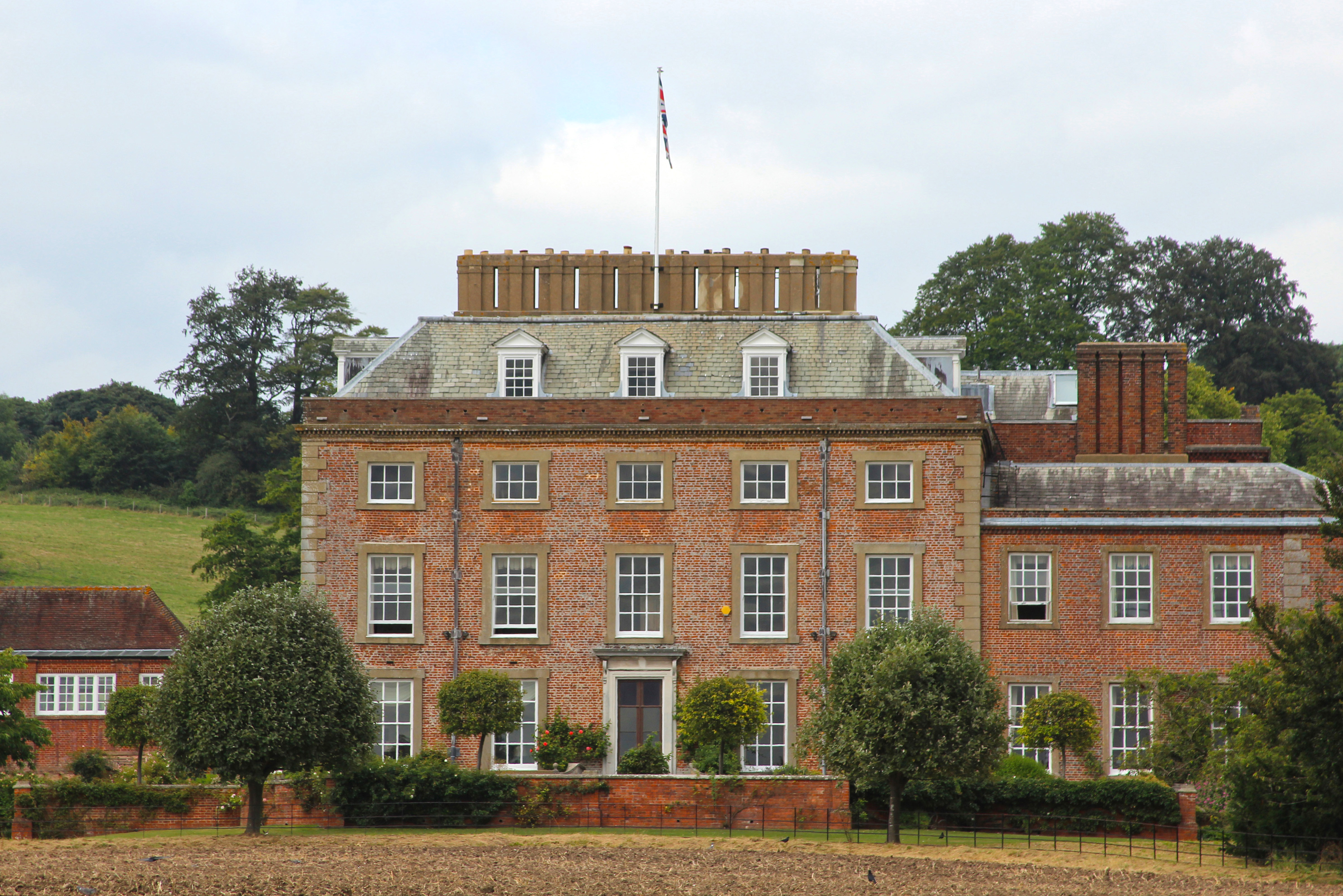
St Clere, Kent

St Clere is a Grade I listed 17th-century country house in Kemsing, Kent, England. The house is built in brick in three storeys plus basement and attic...

Seal, Kent

Seal is a village and civil parish in the Sevenoaks district of Kent, England. The parish is located in the valley between the North Downs and the Greensand...

St Michael's Prep School, Otford

St Michael's Prep School is a coeducational preparatory school in Otford, located in a 100-acre (400,000 m2) site in the North Downs, Kent, England....

Seal Chart

Seal Chart is a village 2 miles (3 km) east of Sevenoaks in Kent, England. It is within the Sevenoaks local government district. It is in the civil parish...

Nearby Amenities

Located within 500m of 51.304438,0.24019297
Barrier: stile
Foot: yes
Lat/Long: 51.3010039/0.2417287
Phone
Check Date: 2022-04-23
Emergency: phone
Lat/Long: 51.3011011/0.2421225
Phone
Emergency: phone
Lat/Long: 51.3013967/0.2421165
Barrier: stile
Foot: yes
Lat/Long: 51.3017777/0.2416411
Kemsing Cricket Club
Addr City: Kemsing
Addr Housename: Sir Mark Collet Pavilion
Addr Postcode: TN15 6NE
Addr Street: Heaverham Road
Leisure: park
Website: kemsing.play-cricket.com
Lat/Long: 51.3069833/0.2360525
The data included in this document is from www.openstreetmap.org. The data is made available under ODbL.

Have you been to Hill's Wood?

Leave your review of Hill's Wood below (or comments, questions and feedback).