Homegrove Wood

Wood, Forest in Sussex Wealden

England

Homegrove Wood

St. Mark's, Hadlow Down, East Sussex
St. Mark's, Hadlow Down, East Sussex Credit: nick macneill

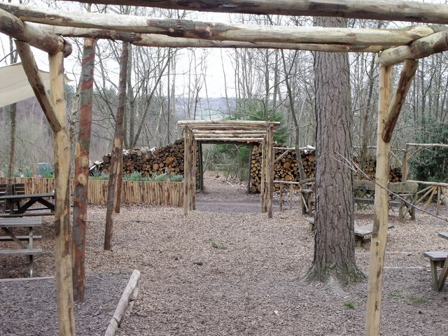
Homegrove Wood is a picturesque woodland located in Sussex, England. Covering an area of approximately 50 acres, it is nestled in the heart of the South Downs National Park, offering visitors a tranquil and scenic retreat from the bustling nearby towns.

This ancient woodland is rich in biodiversity, boasting a diverse range of flora and fauna. The canopy is dominated by majestic oak and beech trees, interspersed with hazel, holly, and yew. In spring, the forest floor comes alive with a vibrant carpet of bluebells, wild garlic, and primroses, creating a breathtaking display of colors.

Homegrove Wood is a haven for wildlife enthusiasts, as it provides a habitat for a variety of species. Birdwatchers can spot woodpeckers, owls, and numerous songbirds among the treetops, while small mammals such as badgers, foxes, and squirrels can be observed scurrying through the undergrowth.

The woodland offers a network of well-maintained trails, inviting walkers, hikers, and nature lovers to explore its hidden treasures. The paths wind through ancient trees, moss-covered rocks, and babbling brooks, creating a sense of enchantment and tranquility.

Managed by the local conservation trust, Homegrove Wood is carefully preserved and protected to ensure the sustainability of its natural beauty. Visitors are encouraged to respect the delicate ecosystem and follow the designated paths, helping to maintain the harmony between human enjoyment and environmental conservation.

Overall, Homegrove Wood in Sussex is a captivating woodland that offers a peaceful escape into nature. Its stunning scenery, diverse wildlife, and well-preserved trails make it a popular destination for outdoor enthusiasts and nature lovers alike.

If you have any feedback on the listing, please let us know in the comments section below.

Homegrove Wood Images

Images are sourced within 2km of 50.988463/0.19939437 or Grid Reference TQ5423. Thanks to Geograph Open Source API. All images are credited.

St. Mark's, Hadlow Down, East Sussex
St. Mark's, Hadlow Down, East Sussex (2)
Picnic area, Wilderness Wood, Hadlow Down Wilderness Wood is a visitor attraction focusing mainly on nature walks and especially wood and its use.
Picnic area, Wilderness Wood, Hadlow Down
Wilderness Wood is a visitor attraction focusing mainly on nature walks and especially wood and its use.
Frog Hole Lane / A267 junction
A267 / A272 junction The A267 road is a 21 mile long road from Tunbridge Wells <a href="https://www.geograph.org.uk/photo/6669020">TQ5838 : A26, A267 junction</a> to Horsebridge.
Website: <span class="nowrap"><a title="http://www.sabre-roads.org.uk/wiki/index.php?title=A267" rel="nofollow ugc noopener" href="http://www.sabre-roads.org.uk/wiki/index.php?title=A267">Link</a><img style="margin-left:2px;" alt="External link" title="External link - shift click to open in new window" src="https://s1.geograph.org.uk/img/external.png" width="10" height="10"/></span>
A267 / A272 junction
The A267 road is a 21 mile long road from Tunbridge Wells TQ5838 : A26, A267 junction to Horsebridge. Website: LinkExternal link
A267 north of the junction with the B2102 The A267 road is a 21 mile long road from Tunbridge Wells <a href="https://www.geograph.org.uk/photo/6669020">TQ5838 : A26, A267 junction</a> to Horsebridge.
Website: <span class="nowrap"><a title="http://www.sabre-roads.org.uk/wiki/index.php?title=A267" rel="nofollow ugc noopener" href="http://www.sabre-roads.org.uk/wiki/index.php?title=A267">Link</a><img style="margin-left:2px;" alt="External link" title="External link - shift click to open in new window" src="https://s1.geograph.org.uk/img/external.png" width="10" height="10"/></span>
A267 north of the junction with the B2102
The A267 road is a 21 mile long road from Tunbridge Wells TQ5838 : A26, A267 junction to Horsebridge. Website: LinkExternal link
A267 looking south The A267 road is a 21 mile long road from Tunbridge Wells <a href="https://www.geograph.org.uk/photo/6669020">TQ5838 : A26, A267 junction</a> to Horsebridge.
Website: <span class="nowrap"><a title="http://www.sabre-roads.org.uk/wiki/index.php?title=A267" rel="nofollow ugc noopener" href="http://www.sabre-roads.org.uk/wiki/index.php?title=A267">Link</a><img style="margin-left:2px;" alt="External link" title="External link - shift click to open in new window" src="https://s1.geograph.org.uk/img/external.png" width="10" height="10"/></span>
A267 looking south
The A267 road is a 21 mile long road from Tunbridge Wells TQ5838 : A26, A267 junction to Horsebridge. Website: LinkExternal link
B2102, Nursery Lane junction
B2102, Possingworth Park
Junction of B2102 and A267
A267 heading north The A267 road is a 21 mile long road from Tunbridge Wells <a href="https://www.geograph.org.uk/photo/6669020">TQ5838 : A26, A267 junction</a> to Horsebridge.
Website: <span class="nowrap"><a title="http://www.sabre-roads.org.uk/wiki/index.php?title=A267" rel="nofollow ugc noopener" href="http://www.sabre-roads.org.uk/wiki/index.php?title=A267">Link</a><img style="margin-left:2px;" alt="External link" title="External link - shift click to open in new window" src="https://s1.geograph.org.uk/img/external.png" width="10" height="10"/></span>
A267 heading north
The A267 road is a 21 mile long road from Tunbridge Wells TQ5838 : A26, A267 junction to Horsebridge. Website: LinkExternal link
The A267 The A267 road is a 21 mile long road from Tunbridge Wells <a href="https://www.geograph.org.uk/photo/6669020">TQ5838 : A26, A267 junction</a> to Horsebridge.
Website: <span class="nowrap"><a title="http://www.sabre-roads.org.uk/wiki/index.php?title=A267" rel="nofollow ugc noopener" href="http://www.sabre-roads.org.uk/wiki/index.php?title=A267">Link</a><img style="margin-left:2px;" alt="External link" title="External link - shift click to open in new window" src="https://s1.geograph.org.uk/img/external.png" width="10" height="10"/></span>
The A267
The A267 road is a 21 mile long road from Tunbridge Wells TQ5838 : A26, A267 junction to Horsebridge. Website: LinkExternal link
Approaching the junction of the A267 and A272 The A267 road is a 21 mile long road from Tunbridge Wells <a href="https://www.geograph.org.uk/photo/6669020">TQ5838 : A26, A267 junction</a> to Horsebridge.
Website: <span class="nowrap"><a title="http://www.sabre-roads.org.uk/wiki/index.php?title=A267" rel="nofollow ugc noopener" href="http://www.sabre-roads.org.uk/wiki/index.php?title=A267">Link</a><img style="margin-left:2px;" alt="External link" title="External link - shift click to open in new window" src="https://s1.geograph.org.uk/img/external.png" width="10" height="10"/></span>
Approaching the junction of the A267 and A272
The A267 road is a 21 mile long road from Tunbridge Wells TQ5838 : A26, A267 junction to Horsebridge. Website: LinkExternal link
A267 south of Poundford The A267 road is a 21 mile long road from Tunbridge Wells <a href="https://www.geograph.org.uk/photo/6669020">TQ5838 : A26, A267 junction</a> to Horsebridge.
Website: <span class="nowrap"><a title="http://www.sabre-roads.org.uk/wiki/index.php?title=A267" rel="nofollow ugc noopener" href="http://www.sabre-roads.org.uk/wiki/index.php?title=A267">Link</a><img style="margin-left:2px;" alt="External link" title="External link - shift click to open in new window" src="https://s1.geograph.org.uk/img/external.png" width="10" height="10"/></span>
A267 south of Poundford
The A267 road is a 21 mile long road from Tunbridge Wells TQ5838 : A26, A267 junction to Horsebridge. Website: LinkExternal link
Entering Five Ashes on the A267 The A267 road is a 21 mile long road from Tunbridge Wells <a href="https://www.geograph.org.uk/photo/6669020">TQ5838 : A26, A267 junction</a> to Horsebridge.
Website: <span class="nowrap"><a title="http://www.sabre-roads.org.uk/wiki/index.php?title=A267" rel="nofollow ugc noopener" href="http://www.sabre-roads.org.uk/wiki/index.php?title=A267">Link</a><img style="margin-left:2px;" alt="External link" title="External link - shift click to open in new window" src="https://s1.geograph.org.uk/img/external.png" width="10" height="10"/></span>
Entering Five Ashes on the A267
The A267 road is a 21 mile long road from Tunbridge Wells TQ5838 : A26, A267 junction to Horsebridge. Website: LinkExternal link
A267 through Five Ashes The A267 road is a 21 mile long road from Tunbridge Wells <a href="https://www.geograph.org.uk/photo/6669020">TQ5838 : A26, A267 junction</a> to Horsebridge.
Website: <span class="nowrap"><a title="http://www.sabre-roads.org.uk/wiki/index.php?title=A267" rel="nofollow ugc noopener" href="http://www.sabre-roads.org.uk/wiki/index.php?title=A267">Link</a><img style="margin-left:2px;" alt="External link" title="External link - shift click to open in new window" src="https://s1.geograph.org.uk/img/external.png" width="10" height="10"/></span>
A267 through Five Ashes
The A267 road is a 21 mile long road from Tunbridge Wells TQ5838 : A26, A267 junction to Horsebridge. Website: LinkExternal link
New Mill, Cross in Hand in 1967 In the days when it had all its sails.
New Mill, Cross in Hand in 1967
In the days when it had all its sails.
Entrance to Button's Farm
Show me another place!

Homegrove Wood is located at Grid Ref: TQ5423 (Lat: 50.988463, Lng: 0.19939437)

Administrative County: East Sussex

District: Wealden

Police Authority: Sussex

What 3 Words

///weeded.churn.existence. Near Buxted, East Sussex

Related Wikis

Great Bush Railway

The Great Bush Railway is a private, 2 ft (610 mm) narrow gauge running round the edge of Tinkers Park, Hadlow Down, Sussex. The railway is operated by...

Southern Sandstone

Southern Sandstone is a local name for the Ardingly Sandstone of southeast England, a soft sandstone of Cretaceous age separating the Tunbridge Wells Sands...

Wealden (UK Parliament constituency)

Wealden is a constituency represented in the House of Commons of the UK Parliament since 2015 by Nus Ghani, a Conservative. Ghani is the first Muslim woman...

Wealden District

Wealden is a local government district in East Sussex, England. Its council is based in Hailsham, the district's largest town. The district also includes...

Five Ash Down Independent Chapel

Five Ash Down Independent Chapel is an independent Evangelical church in the Reformed (Calvinist) tradition in the hamlet of Five Ash Down, East Sussex...

Providence Chapel, Hadlow Down

Providence Chapel is a former independent Calvinistic place of worship in the village of Hadlow Down in Wealden, one of six local government districts...

St Mark's Church, Hadlow Down

St Mark's Church (dedicated to St Mark the Evangelist) is an Anglican church in the village of Hadlow Down in the district of Wealden, one of six local...

Hadlow Down

Hadlow Down is a village and civil parish in the Wealden District of East Sussex, England. It is located on the A272 road three miles (4.8 km) north-west...

Have you been to Homegrove Wood?

Leave your review of Homegrove Wood below (or comments, questions and feedback).