Cage Wood

Wood, Forest in Sussex Wealden

England

Cage Wood

Foxy Field/Round Field The name of the fields according to Withyham's 1842 tithe map that have been merged to form a larger unit. Foxy Field is in the foreground whilst Round Field is beyond the hedgerow in the distance adjacent to Badbrook Wood. Now part of Park Grove Deer Farm.
Foxy Field/Round Field Credit: Simon Carey

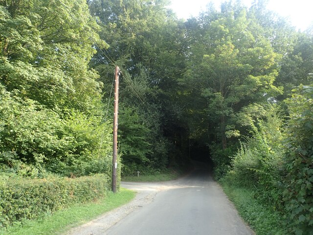
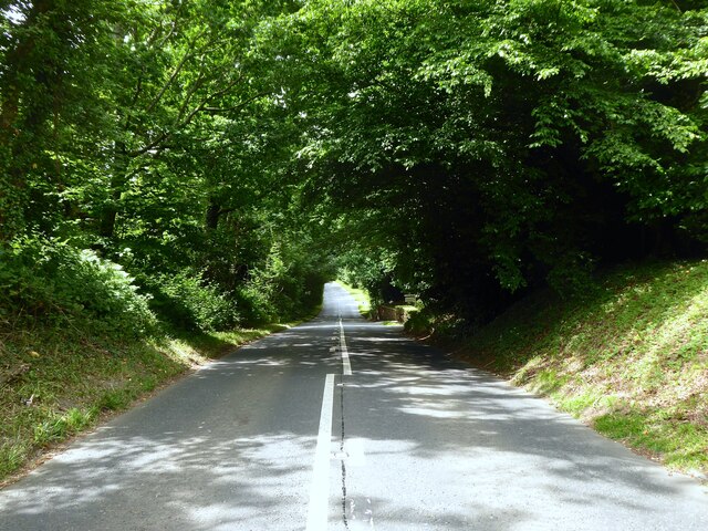
Cage Wood, located in Sussex, England, is a picturesque woodland area renowned for its natural beauty and rich history. Covering an expansive area of approximately 84 hectares, the wood is nestled within the High Weald Area of Outstanding Natural Beauty.

The woodland is predominantly composed of oak and beech trees, with a diverse range of flora and fauna thriving within its boundaries. The vibrant carpet of bluebells that bloom during the springtime is a particularly mesmerizing sight, attracting numerous visitors and photographers alike.

Cage Wood holds significant historical importance, dating back to the medieval era. The remnants of a motte-and-bailey castle, believed to have been constructed in the 11th century, can still be found within the wood, adding an air of mystery and intrigue to the area. The castle was likely built by the Normans and served as a defensive structure during the medieval period.

Today, Cage Wood offers a tranquil escape for nature enthusiasts and hikers. Numerous well-maintained walking trails provide visitors with the opportunity to explore the wood's diverse landscapes, including ancient woodland, open meadows, and serene ponds. The wood is also home to a variety of wildlife, including deer, badgers, and a plethora of bird species.

Cage Wood is open to the public year-round and offers ample parking facilities for visitors. The wood's accessibility, natural beauty, and historical significance make it a must-visit destination for those seeking a peaceful retreat in the heart of Sussex.

If you have any feedback on the listing, please let us know in the comments section below.

Cage Wood Images

Images are sourced within 2km of 51.069559/0.1758019 or Grid Reference TQ5232. Thanks to Geograph Open Source API. All images are credited.

Foxy Field/Round Field The name of the fields according to Withyham's 1842 tithe map that have been merged to form a larger unit. Foxy Field is in the foreground whilst Round Field is beyond the hedgerow in the distance adjacent to Badbrook Wood. Now part of Park Grove Deer Farm.
Foxy Field/Round Field
The name of the fields according to Withyham's 1842 tithe map that have been merged to form a larger unit. Foxy Field is in the foreground whilst Round Field is beyond the hedgerow in the distance adjacent to Badbrook Wood. Now part of Park Grove Deer Farm.
Park Grove/Long Field The name of the fields according to Withyham's 1842 tithe map that have been merged to form a larger unit. Park Grove is in the foreground whilst Long field was to the east adjacent to Badbrook Wood. Both are bounded to the south by Parkgrove Wood.
Park Grove/Long Field
The name of the fields according to Withyham's 1842 tithe map that have been merged to form a larger unit. Park Grove is in the foreground whilst Long field was to the east adjacent to Badbrook Wood. Both are bounded to the south by Parkgrove Wood.
Barn Mead The name of the field according to Withyham's 1842 tithe map located to the south of Park Grove.
Barn Mead
The name of the field according to Withyham's 1842 tithe map located to the south of Park Grove.
Park Grove Cottage Former farm outbuilding belonging to Parkgrove Farm whose original farmhouse, now called Home Place, can be seen in the distance.
Park Grove Cottage
Former farm outbuilding belonging to Parkgrove Farm whose original farmhouse, now called Home Place, can be seen in the distance.
Home Place Originally a farmhouse for Wiggs Farm later known as Parkgrove Farm. Now converted into a residence.
Home Place
Originally a farmhouse for Wiggs Farm later known as Parkgrove Farm. Now converted into a residence.
Gate Field/Hollands Field The name of the fields according to Withyham's 1842 tithe map that have been merged to form a larger unit. Gate field was in the foreground whilst Hollands Field was on the slope in the distance.
Gate Field/Hollands Field
The name of the fields according to Withyham's 1842 tithe map that have been merged to form a larger unit. Gate field was in the foreground whilst Hollands Field was on the slope in the distance.
View from Sandhill Lane This is close to and within the sound of the A26.
View from Sandhill Lane
This is close to and within the sound of the A26.
View from Sandhill Lane This is close to Sandhill Cottages and looks across the valley through which the Uckfield line runs.
View from Sandhill Lane
This is close to Sandhill Cottages and looks across the valley through which the Uckfield line runs.
View from Sandhill Lane This view is close to Sandhill Cottages, which are on the right, and looks across the valley through which the Uckfield line runs.
View from Sandhill Lane
This view is close to Sandhill Cottages, which are on the right, and looks across the valley through which the Uckfield line runs.
Sandhill Lane Sandhill Lane enters Slab Wood just ahead. This is close to and within the sound of the A26.
Sandhill Lane
Sandhill Lane enters Slab Wood just ahead. This is close to and within the sound of the A26.
Providence Cottages, School Lane, St John's, Crowborough A set of four semi-detached cottages built in the first decade of the 20th century.
Providence Cottages, School Lane, St John's, Crowborough
A set of four semi-detached cottages built in the first decade of the 20th century.
Sandhill Cottages
Sandhill Cottages
Slab Wood
Slab Wood
Five Acre Field The name of the field according to Withyham's 1842 tithe map bounded by Royalmires Wood to the north. Interesting that the tithe map has this as a field but every OS map since 1874 has this the southern extension to the wood.
Five Acre Field
The name of the field according to Withyham's 1842 tithe map bounded by Royalmires Wood to the north. Interesting that the tithe map has this as a field but every OS map since 1874 has this the southern extension to the wood.
Summersales Hill The name of this road between Royalmires Wood and the junction with Hoadleys Lane becoming London Road as it heads into Crowborough.
Summersales Hill
The name of this road between Royalmires Wood and the junction with Hoadleys Lane becoming London Road as it heads into Crowborough.
Pedlars Mead Pit The name of the former wood according to Withyham's 1842 tithe map which contained an old quarry that since been landscaped into a pond.
Pedlars Mead Pit
The name of the former wood according to Withyham's 1842 tithe map which contained an old quarry that since been landscaped into a pond.
Pedlars Mead Four Acres The name of the field according to Withyham's 1842 tithe map bounded to the east by Summersales Hill.
Pedlars Mead Four Acres
The name of the field according to Withyham's 1842 tithe map bounded to the east by Summersales Hill.
Add's Farm Located at the end of Hoadleys Lane.
Add's Farm
Located at the end of Hoadleys Lane.
Show me another place!

Cage Wood is located at Grid Ref: TQ5232 (Lat: 51.069559, Lng: 0.1758019)

Administrative County: East Sussex

District: Wealden

Police Authority: Sussex

What 3 Words

///resorting.slippery.swims. Near Crowborough, East Sussex

Related Wikis

Bream Wood

Bream Wood is a 7.8-hectare (19-acre) biological Site of Special Scientific Interest north of Crowborough in East Sussex.This steep sided valley wood has...

Pratt's Mill, Crowborough

Pratt's Mill is a tower mill at Crowborough, Sussex, England which has been truncated and converted to residential accommodation. == History == Pratt...

Crowborough Community Church

Crowborough Community Church (also known as Community Church, Crowborough) is an Evangelical church in the town of Crowborough in East Sussex, England...

Crowborough

Crowborough is a town and civil parish in East Sussex, England, in the Weald at the edge of Ashdown Forest in the High Weald Area of Outstanding Natural...

Beacon Academy

Beacon Academy (formerly Beacon Community College) is a coeducational secondary school and sixth form located in Crowborough in the English county of East...

Bowles Rocks

Bowles Rocks is a sandstone crag in the county of East Sussex, on the border with Kent, approximately 8 kilometres (5 mi) south of the town of Royal Tunbridge...

Bowles Outdoor Centre

Bowles Outdoor Centre is an outdoor education/outdoor learning centre in southeast England, located between Royal Tunbridge Wells and Crowborough at Bowles...

A26 road

The A26 road is a primary route in the southeast of England, going from Maidstone to Newhaven through the counties of Kent and East Sussex. The road is...

Have you been to Cage Wood?

Leave your review of Cage Wood below (or comments, questions and feedback).