Birchcope Shaw

Wood, Forest in Kent Sevenoaks

England

Birchcope Shaw

Pond by the railway The railway is not very obvious in this view, but the Uckfield line is on a high embankment behind the pond. A faint horizontal line halfway up the trees is the track.
Pond by the railway Credit: Robin Webster

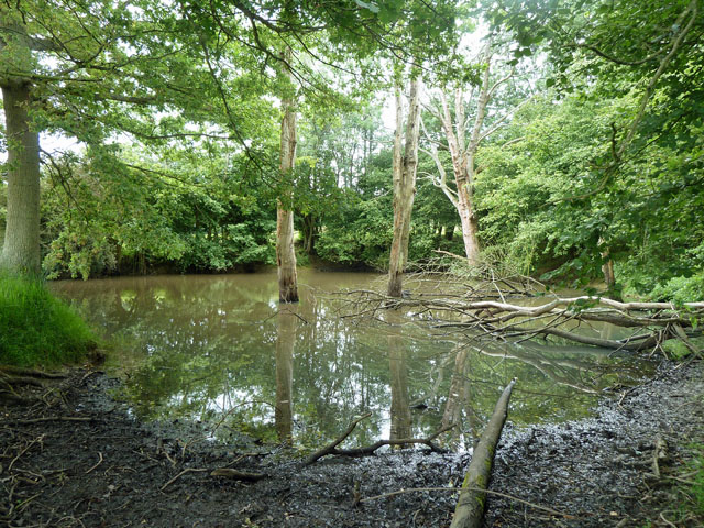
Birchcope Shaw is a picturesque woodland located in Kent, England. Spread across a vast area, it is known for its dense birch tree population, which gives the shaw its name. The woodland primarily consists of silver birch trees, with their distinctive white bark and delicate leaves, creating a captivating sight throughout the year.

Situated in the heart of the Kent countryside, Birchcope Shaw offers a tranquil escape from the bustling city life. The peaceful ambiance combined with the enchanting beauty of the forest makes it a popular destination for nature enthusiasts, hikers, and photographers.

The woodland is home to a diverse range of flora and fauna, providing a thriving ecosystem. Visitors can spot a variety of woodland creatures, including deer, rabbits, squirrels, and various species of birds. The delicate wildflowers that bloom in the spring and summer add a burst of color to the serene surroundings.

Birchcope Shaw is well-equipped with walking trails that wind their way through the forest, allowing visitors to explore its hidden gems. These trails cater to all levels of fitness and are suitable for families, couples, and individuals alike. The sound of rustling leaves underfoot and the scent of fresh pine permeate the air, further enhancing the sensory experience.

Whether it's a leisurely stroll, a picnic amidst the trees, or simply a moment of solitude in nature, Birchcope Shaw provides an idyllic setting for relaxation and rejuvenation. It is a cherished natural gem in Kent, attracting locals and tourists alike with its timeless beauty and tranquil charm.

If you have any feedback on the listing, please let us know in the comments section below.

Birchcope Shaw Images

Images are sourced within 2km of 51.158845/0.13536453 or Grid Reference TQ4942. Thanks to Geograph Open Source API. All images are credited.

Pond by the railway The railway is not very obvious in this view, but the Uckfield line is on a high embankment behind the pond. A faint horizontal line halfway up the trees is the track.
Pond by the railway
The railway is not very obvious in this view, but the Uckfield line is on a high embankment behind the pond. A faint horizontal line halfway up the trees is the track.
Sandstone outcrop Nearly the most easterly of a long line of crags, most of which are rather overgrown, along the south side of the valley,
Sandstone outcrop
Nearly the most easterly of a long line of crags, most of which are rather overgrown, along the south side of the valley,
A secluded field Having emerged from gill woodland behind the camera, footpath SR537 faintly follows the field margin around the bend to the right.
A secluded field
Having emerged from gill woodland behind the camera, footpath SR537 faintly follows the field margin around the bend to the right.
Curds This pair of cottages are labelled 'Curds' on the larger scale maps. A rather secluded spot, but footpath SR534 does pass them by. In principle this footpath should head straight across the field towards them from the viewpoint.
Curds
This pair of cottages are labelled 'Curds' on the larger scale maps. A rather secluded spot, but footpath SR534 does pass them by. In principle this footpath should head straight across the field towards them from the viewpoint.
View towards Horseshoe Green The large barn is part of Horseshoe Green Farm, and seems to be a milking barn, judging by the number of cows in the yard and the loud humming noise radiating from it when passed at about 16:45.
View towards Horseshoe Green
The large barn is part of Horseshoe Green Farm, and seems to be a milking barn, judging by the number of cows in the yard and the loud humming noise radiating from it when passed at about 16:45.
Mark Beech Tunnel, southern portal Although the tunnel passes under the village of Markbeech, the railways have chosen a two word version of the name for the tunnel, unless their sign writer got it wrong. It is 1342 yards long - with the same proviso! It appears to be fitted with an antenna relay to enable radio reception within the tunnel. The faint white patch on the brickwork to the left of the portal must have been a sighting aid for a semaphore signal close to the tunnel mouth. The tunnel and line as a whole were built for double track, but it is now single over much of its length. This has enabled a comfortably wide inspection walkway fenced off from the track to be made through the tunnel - the end of the blue fence may be seen.
Mark Beech Tunnel, southern portal
Although the tunnel passes under the village of Markbeech, the railways have chosen a two word version of the name for the tunnel, unless their sign writer got it wrong. It is 1342 yards long - with the same proviso! It appears to be fitted with an antenna relay to enable radio reception within the tunnel. The faint white patch on the brickwork to the left of the portal must have been a sighting aid for a semaphore signal close to the tunnel mouth. The tunnel and line as a whole were built for double track, but it is now single over much of its length. This has enabled a comfortably wide inspection walkway fenced off from the track to be made through the tunnel - the end of the blue fence may be seen.
Track components by the track, Cowden Cowden station may just be glimpsed around the bend.
Track components by the track, Cowden
Cowden station may just be glimpsed around the bend.
A barren field The field seems to have been sprayed with weedkiller before much grew - the principal recoloniser, or more likely, survivor, is a Dock. The white patch is not water, but the remains of a  heap of some material like lime. The woodland beyond is Stock Wood.
A barren field
The field seems to have been sprayed with weedkiller before much grew - the principal recoloniser, or more likely, survivor, is a Dock. The white patch is not water, but the remains of a heap of some material like lime. The woodland beyond is Stock Wood.
Trees on old hedge line There are a couple more isolated trees out of shot to the left, marking where this field was once two.
Trees on old hedge line
There are a couple more isolated trees out of shot to the left, marking where this field was once two.
Pond by road north of Hoath Corner This is one of several in this area, excavated in the Wadhurst Clay either to extract marl for use on more acid soils, or to extract ironstone.
Pond by road north of Hoath Corner
This is one of several in this area, excavated in the Wadhurst Clay either to extract marl for use on more acid soils, or to extract ironstone.
Cowden station, 1987 View NW, towards Oxted and London: ex-London, Brighton & South Coast Railway, London - Oxted - Ashurst - Tunbridge Wells West/Uckfield - Lewes - Brighton/Eridge - Eastbourne lines. Since 8/7/85, when the Tunbridge Wells West line was closed, trains have run through here only to Uckfield. (See also <a href="https://www.geograph.org.uk/photo/3322860">TQ4741 : Cowden station, 1987</a>).
Cowden station, 1987
View NW, towards Oxted and London: ex-London, Brighton & South Coast Railway, London - Oxted - Ashurst - Tunbridge Wells West/Uckfield - Lewes - Brighton/Eridge - Eastbourne lines. Since 8/7/85, when the Tunbridge Wells West line was closed, trains have run through here only to Uckfield. (See also TQ4741 : Cowden station, 1987).
Cowden station, 1987 View SE, towards Ashurst and Uckfield: ex-London, Brighton & South Coast Railway, London - Oxted - Ashurst - Tunbridge Wells West/Uckfield - Lewes - Brighton/Eridge - Eastbourne lines. Since 8/7/85 when the Tunbridge Wells West line closed, trains through here have gone no further than Uckfield. (See also <a href="https://www.geograph.org.uk/photo/3322842">TQ4741 : Cowden station, 1987</a>).
Cowden station, 1987
View SE, towards Ashurst and Uckfield: ex-London, Brighton & South Coast Railway, London - Oxted - Ashurst - Tunbridge Wells West/Uckfield - Lewes - Brighton/Eridge - Eastbourne lines. Since 8/7/85 when the Tunbridge Wells West line closed, trains through here have gone no further than Uckfield. (See also TQ4741 : Cowden station, 1987).
Cowden railway station, Kent Opened in 1888 by the London Brighton & South Coast Railway on the line from Oxted to Uckfield. View north west towards Hever and Oxted.
Cowden railway station, Kent
Opened in 1888 by the London Brighton & South Coast Railway on the line from Oxted to Uckfield. View north west towards Hever and Oxted.
Footpath leaving Stock Wood Although the bridleway is dry here, further on it is severely cut up by horses.
Footpath leaving Stock Wood
Although the bridleway is dry here, further on it is severely cut up by horses.
Footpath on the edge of Stock Wood Although the bridleway is dry here, further on, especially in Newtye Hurst, it is severely cut up by horses.
Footpath on the edge of Stock Wood
Although the bridleway is dry here, further on, especially in Newtye Hurst, it is severely cut up by horses.
Lane near Wilderness Farm Wilderness Farm is just ahead, as is the junction with the lane leading to Newtown.
Lane near Wilderness Farm
Wilderness Farm is just ahead, as is the junction with the lane leading to Newtown.
Bridleway in Newtye Hurst Although the bridleway looks dry here, it was exceedingly muddy elsewhere and had been churned up by horses.
Bridleway in Newtye Hurst
Although the bridleway looks dry here, it was exceedingly muddy elsewhere and had been churned up by horses.
Chiddingstone Hoath, Kent
Show me another place!

Birchcope Shaw is located at Grid Ref: TQ4942 (Lat: 51.158845, Lng: 0.13536453)

Administrative County: Kent

District: Sevenoaks

Police Authority: Kent

What 3 Words

///jigsaw.seashell.unwound. Near Speldhurst, Kent

Related Wikis

Chiddingstone Hoath

Chiddingstone Hoath is a hamlet in the Sevenoaks District of Kent, England. Notable buildings include Hoath House, and Stonewall Park, for some time home...

Cowden Meadow

Cowden Meadow is a 1.1-hectare (2.7-acre) biological Site of Special Scientific Interest east of Cowden in Kent.This site has flora which are found on...

Cowden rail crash

The Cowden rail crash occurred on 15 October 1994, near Cowden Station in Kent (UK), when two trains collided head-on, killing five and injuring thirteen...

Cowden railway station

Cowden railway station is on the Uckfield branch of the Oxted line in southern England and serves Cowden in Kent. It is 29 miles 26 chains (29.33 miles...

LeeFest

Neverworld, formerly known as LeeFest, is a music festival that takes place each Summer in Kent, England. The festival began in founder Lee Denny's garden...

Markbeech

Markbeech (sometimes styled Mark Beech) is a village in the civil parish of Hever in the Sevenoaks district of Kent, England. The village is located on...

Blackham

Blackham is a village in the Wealden district of East Sussex. It lies within the Withyham civil parish. Its nearest town is Royal Tunbridge Wells, which...

Chiddingstone Castle

Chiddingstone Castle is situated in the village of Chiddingstone, near Edenbridge, Kent, England, 35 miles (56 kilometres) south-southeast of London and...

Nearby Amenities

Located within 500m of 51.158845,0.13536453
Barrier: stile
Lat/Long: 51.1584065/0.13888
Barrier: stile
Lat/Long: 51.1558566/0.1326791
Barrier: kissing_gate
Lat/Long: 51.1622168/0.1381267
The data included in this document is from www.openstreetmap.org. The data is made available under ODbL.

Have you been to Birchcope Shaw?

Leave your review of Birchcope Shaw below (or comments, questions and feedback).