Foxburrow Wood

Wood, Forest in Kent

England

Foxburrow Wood

Steps in Twenty Acre Shaw Twenty Acre Shaw is part of a Site of Metropolitan Importance for Nature Conservation and is therefore one of the best woodlands in Greater London. A path drops steeply from Single Street down a series of steps to reach the grassy valley bottom before ascending to Cudham. This view looks back up the steps. Twenty Acre Shaw is managed by the Woodland Trust and is also a SSSI.
Steps in Twenty Acre Shaw Credit: Marathon

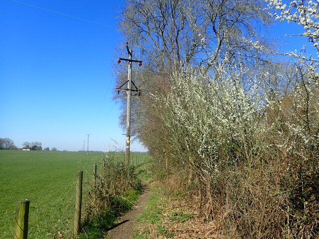
Foxburrow Wood is a beautiful woodland located in the county of Kent, England. Covering an area of approximately 50 acres, it is known for its stunning natural beauty and diverse range of flora and fauna. The wood is situated near the village of Seal, just a few miles south of Sevenoaks.

The wood is primarily composed of mixed broadleaf trees, including oak, beech, and ash, creating a picturesque and tranquil environment. These trees provide a dense canopy, offering shade and shelter to a variety of wildlife species. Foxburrow Wood is home to numerous bird species, including woodpeckers, owls, and thrushes, making it a popular spot for birdwatching enthusiasts.

In addition to its rich birdlife, the wood also supports a wide range of mammals, such as foxes, rabbits, and squirrels. These creatures can often be spotted scurrying through the undergrowth or foraging for food amongst the fallen leaves.

Visitors to Foxburrow Wood can explore its many walking trails, which wind through the enchanting woodland and offer glimpses of its natural wonders along the way. The wood is particularly popular during spring when the forest floor is covered in a vibrant carpet of bluebells, creating a breathtaking sight.

Managed by a local conservation organization, Foxburrow Wood is well-maintained and offers a peaceful retreat for nature lovers and those seeking a break from the hustle and bustle of everyday life. With its diverse ecosystem and stunning scenery, Foxburrow Wood is a true gem of Kent's natural landscape.

If you have any feedback on the listing, please let us know in the comments section below.

Foxburrow Wood Images

Images are sourced within 2km of 51.322735/0.085572124 or Grid Reference TQ4560. Thanks to Geograph Open Source API. All images are credited.

Steps in Twenty Acre Shaw Twenty Acre Shaw is part of a Site of Metropolitan Importance for Nature Conservation and is therefore one of the best woodlands in Greater London. A path drops steeply from Single Street down a series of steps to reach the grassy valley bottom before ascending to Cudham. This view looks back up the steps. Twenty Acre Shaw is managed by the Woodland Trust and is also a SSSI.
Steps in Twenty Acre Shaw
Twenty Acre Shaw is part of a Site of Metropolitan Importance for Nature Conservation and is therefore one of the best woodlands in Greater London. A path drops steeply from Single Street down a series of steps to reach the grassy valley bottom before ascending to Cudham. This view looks back up the steps. Twenty Acre Shaw is managed by the Woodland Trust and is also a SSSI.
Cudham Shaws Camp Site Formerly a camp site for Girl Guides, the camp site was taken over by Bexley Scout District from April 2022 - see <span class="nowrap"><a title="www.bexleyscouts.org.uk/district-campsite" rel="nofollow ugc noopener" href="http://www.bexleyscouts.org.uk/district-campsite">Link</a><img style="margin-left:2px;" alt="External link" title="External link - shift click to open in new window" src="https://s1.geograph.org.uk/img/external.png" width="10" height="10"/></span>  It is at the bottom of a steep valley between Cudham and Downe.
Cudham Shaws Camp Site
Formerly a camp site for Girl Guides, the camp site was taken over by Bexley Scout District from April 2022 - see LinkExternal link It is at the bottom of a steep valley between Cudham and Downe.
Coal Tax post on Cudham Lane This is one of the City of London Coal Tax posts. Coal Tax posts were marker posts, first erected in 1851 and forming a rough circle about twenty miles from the centre of London to mark the points where taxes on coal and wine due to the Corporation of London had to be paid. Of the original 250 or so, 211 have survived. They are often found now in very out of the way and unlikely places. 

A remarkable 13 of these can be seen on the two mile walk across Banstead Heath, which continues across Walton Heath Golf Course to Colley Hill - see <a title="www.geograph.org.uk/photo/4045637" href="https://www.geograph.org.uk/photo/4045637">Link</a>
Coal Tax post on Cudham Lane
This is one of the City of London Coal Tax posts. Coal Tax posts were marker posts, first erected in 1851 and forming a rough circle about twenty miles from the centre of London to mark the points where taxes on coal and wine due to the Corporation of London had to be paid. Of the original 250 or so, 211 have survived. They are often found now in very out of the way and unlikely places. A remarkable 13 of these can be seen on the two mile walk across Banstead Heath, which continues across Walton Heath Golf Course to Colley Hill - see Link
Footpath through woodland A footpath leads from Hookwood Road and passes through Lattice Coppice to reach Perrys Lane. This is remote countryside, although it is in Greater London. In this view, the path is climbing through the woodland with Lattice Coppice to the right and Birchingbank Wood to the left.
Footpath through woodland
A footpath leads from Hookwood Road and passes through Lattice Coppice to reach Perrys Lane. This is remote countryside, although it is in Greater London. In this view, the path is climbing through the woodland with Lattice Coppice to the right and Birchingbank Wood to the left.
Fairtrough Road This is remote countryside, although it is in Greater London.
Fairtrough Road
This is remote countryside, although it is in Greater London.
Upper Brooms Wood This is a fairly spaced-out woodland. It is seen from Fairtrough Road. This is remote countryside, although it is in Greater London.
Upper Brooms Wood
This is a fairly spaced-out woodland. It is seen from Fairtrough Road. This is remote countryside, although it is in Greater London.
Fairtrough Road Fairtrough Cottage is just ahead which operates as a cattery. This is remote countryside, although it is in Greater London.
Fairtrough Road
Fairtrough Cottage is just ahead which operates as a cattery. This is remote countryside, although it is in Greater London.
Fairtrough Road Fairtrough Cottage is just ahead which operates as a cattery. This is remote countryside, although it is in Greater London.
Fairtrough Road
Fairtrough Cottage is just ahead which operates as a cattery. This is remote countryside, although it is in Greater London.
Footpath alongside Birchingbank Wood A footpath leads from Perry Lane and passes between Lattice Coppice and Birchingbank Wood to reach Hookwood Road close to Coolings Garden Centre. This is remote countryside, although it is in Greater London. Perry Lane is just behind and Birchingbank Wood is on the right.
Footpath alongside Birchingbank Wood
A footpath leads from Perry Lane and passes between Lattice Coppice and Birchingbank Wood to reach Hookwood Road close to Coolings Garden Centre. This is remote countryside, although it is in Greater London. Perry Lane is just behind and Birchingbank Wood is on the right.
Sheep near Rushmore Hill Farm A footpath leads from Perry Lane and passes between Lattice Coppice and Birchingbank Wood to reach Hookwood Road close to Coolings Garden Centre. This is remote countryside, although it is in Greater London. This is after passing through the woodland.
Sheep near Rushmore Hill Farm
A footpath leads from Perry Lane and passes between Lattice Coppice and Birchingbank Wood to reach Hookwood Road close to Coolings Garden Centre. This is remote countryside, although it is in Greater London. This is after passing through the woodland.
Newyears Wood
Newyears Wood
Newyears Wood
Newyears Wood
Newyears Wood
Newyears Wood
Footpath across misty field
Misty downland scene
Show me another place!

Foxburrow Wood is located at Grid Ref: TQ4560 (Lat: 51.322735, Lng: 0.085572124)

Unitary Authority: Bromley

Police Authority: Metropolitan

What 3 Words

///souk.remove.pinch. Near Biggin Hill, London

Related Wikis

Cudham

Cudham is an area in Greater London, England, located within the London Borough of Bromley and beyond London's urban sprawl. It is located on the Greater...

London Borough of Bromley

The London Borough of Bromley ( ) is a borough in London, England. It borders the county of Kent, of which it formed part of until 1965. The borough's...

Hazelwood, London

Hazelwood is a hamlet in Greater London, England. It is located within the London Borough of Bromley, to the east of Downe. == References ==

Downe Bank

Downe Bank is a nature reserve owned and managed by the Kent Wildlife Trust in the North Downs, close to Downe in the London Borough of Bromley. It is...

Related Videos

Knockholt Circular via Downe and Cudham | Cool Dudes Walking Club

swcwalks #swcwalk7 A 13-mile stroll from Knockholt, round Pratt's Bottom, Downe, Cudham and back again. This walk was taken ...

Knockholt to Otford Walk: Exploring Scenic Trails in England | Hiking UK 🇬🇧

Join us as we embark on a picturesque journey along the Knockholt to Otford walk, a captivating trail in England. This scenic hike ...

Behind the Scenes at Down House with Chris Packham

Read the full story here: http://ow.ly/CmAjq Discover more in our online Members' Magazine: http://ow.ly/CmAmH Join naturalist ...

Down House - A Tour of Charles Darwin's Gardens

Take a tour of the vibrant gardens of Down House in Kent, once home to Charles Darwin and his family, with head gardener ...

Nearby Amenities

Located within 500m of 51.322735,0.085572124
Barrier: stile
Foot: yes
Material: wood
Stile: stepover
Lat/Long: 51.3250373/0.0894278
Barrier: stile
Foot: yes
Material: wood
Source: survey
Stile: stepover
Lat/Long: 51.3249173/0.0903492
Barrier: stile
Foot: yes
Material: wood
Stile: stepover
Lat/Long: 51.325355/0.0878216
Barrier: stile
Foot: yes
Material: wood
Stile: stepover
Lat/Long: 51.3256509/0.086869
Power: pole
Lat/Long: 51.3219396/0.0800229
Power: pole
Lat/Long: 51.3220744/0.081508
Power: pole
Lat/Long: 51.3203838/0.0831286
Power: pole
Lat/Long: 51.3214775/0.0830362
Power: pole
Lat/Long: 51.3222091/0.0829746
Power: pole
Lat/Long: 51.3234799/0.0844719
Power: pole
Lat/Long: 51.3241038/0.0852422
Power: pole
Lat/Long: 51.3251165/0.084817
Power: pole
Lat/Long: 51.3261562/0.0843857
Power: pole
Lat/Long: 51.3239357/0.0869684
Power: pole
Lat/Long: 51.319116/0.083204
The data included in this document is from www.openstreetmap.org. The data is made available under ODbL.

Have you been to Foxburrow Wood?

Leave your review of Foxburrow Wood below (or comments, questions and feedback).