Ash Plantation

Wood, Forest in Kent Sevenoaks

England

Ash Plantation

Crippenden Manor, Cowden Crippenden Manor, built in about 1607.  Currently apparently operating as a stud / riding school.
Crippenden Manor, Cowden Credit: Jeff

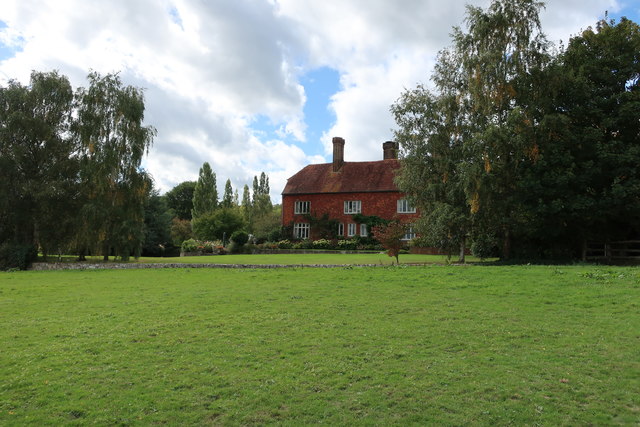
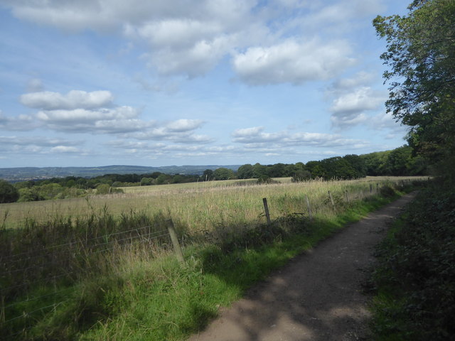
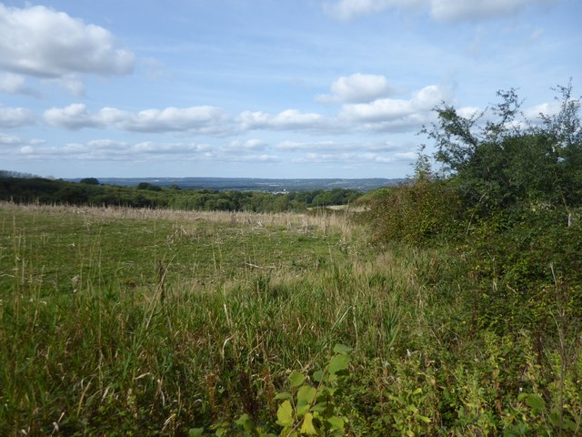
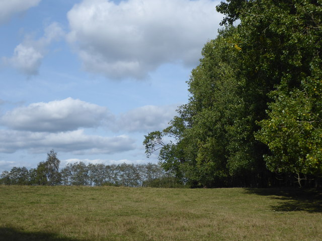
Ash Plantation is a picturesque woodland located in the county of Kent, England. Spanning approximately 10 acres, this enchanting forest is known for its dense growth of ash trees, which give the plantation its name. The woodland is situated in a rural area, surrounded by rolling hills and offering a tranquil escape from the bustling city life.

The ash trees in Ash Plantation are known for their tall and elegant trunks, reaching heights of up to 30 meters. The canopy of the forest provides a cool and shaded environment, creating a pleasant atmosphere for visitors to explore. The woodland floor is covered in a thick layer of fallen leaves, creating a soft carpet underfoot and adding to the natural charm of the area.

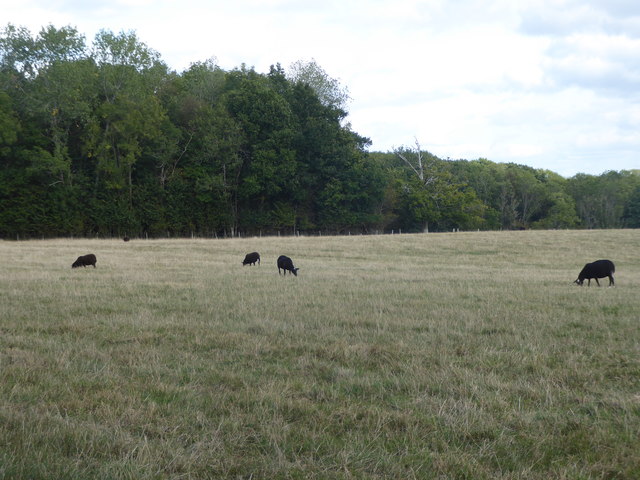
The plantation is home to a diverse range of flora and fauna. It is a haven for birdwatchers, with various species of birds, including woodpeckers and owls, making their nests among the trees. The forest floor is scattered with wildflowers, creating a burst of color during the spring and summer months. Small mammals such as squirrels and rabbits can also be spotted darting through the undergrowth.

Ash Plantation offers various walking trails and paths for visitors to enjoy. These paths wind their way through the woodland, allowing visitors to immerse themselves in the peace and tranquility of nature. The plantation is a popular destination for hikers, nature enthusiasts, and photographers, who are drawn to the beauty and serenity of the forest.

Overall, Ash Plantation in Kent is a charming woodland retreat, offering a serene escape from the outside world. With its towering ash trees, diverse wildlife, and peaceful atmosphere, it is a destination that appeals to both locals and tourists seeking a connection with nature.

If you have any feedback on the listing, please let us know in the comments section below.

Ash Plantation Images

Images are sourced within 2km of 51.160889/0.062030825 or Grid Reference TQ4442. Thanks to Geograph Open Source API. All images are credited.

Crippenden Manor, Cowden Crippenden Manor, built in about 1607.  Currently apparently operating as a stud / riding school.
Crippenden Manor, Cowden
Crippenden Manor, built in about 1607. Currently apparently operating as a stud / riding school.
Field of sheep This view is from the Sussex Border Path.
Field of sheep
This view is from the Sussex Border Path.
The Sussex Border Path near Cowden This view is of the Sussex Border Path looking back towards Cowden.
The Sussex Border Path near Cowden
This view is of the Sussex Border Path looking back towards Cowden.
The Sussex Border Path near Cowden This view is of the Sussex Border Path looking back towards Cowden.
The Sussex Border Path near Cowden
This view is of the Sussex Border Path looking back towards Cowden.
View from the Sussex Border Path near Cowden This view is from the Sussex Border Path looking towards Liveroxhill Wood.
View from the Sussex Border Path near Cowden
This view is from the Sussex Border Path looking towards Liveroxhill Wood.
Pond next to the Sussex Border Path The Sussex Border Path has been diverted here and rather than go around the edge of the field it now passes through the centre and between two ponds.
Pond next to the Sussex Border Path
The Sussex Border Path has been diverted here and rather than go around the edge of the field it now passes through the centre and between two ponds.
Horses on a footpath This is a little way off the Sussex Border Path.
Horses on a footpath
This is a little way off the Sussex Border Path.
Horses on a footpath This is close to the Sussex Border Path.
Horses on a footpath
This is close to the Sussex Border Path.
View from the Sussex Border Path This is just after the Sussex Border Path emerges from Jules Wood. The Greensand Ridge is away to the left on the horizon.
View from the Sussex Border Path
This is just after the Sussex Border Path emerges from Jules Wood. The Greensand Ridge is away to the left on the horizon.
View towards the Greensand Ridge This is just a few yards away the Sussex Border Path near Smoky Wood. The Greensand Ridge is in the distance on the horizon.
View towards the Greensand Ridge
This is just a few yards away the Sussex Border Path near Smoky Wood. The Greensand Ridge is in the distance on the horizon.
A field of black sheep There were about twelve sheep in this field and they were all black. This is near Beeches Farm on a footpath linking the Sussex Border Path with the Vanguard Way.
A field of black sheep
There were about twelve sheep in this field and they were all black. This is near Beeches Farm on a footpath linking the Sussex Border Path with the Vanguard Way.
On the Vanguard Way The Vanguard Way runs from East Croydon station to Newhaven - see <span class="nowrap"><a title="https://ldwa.org.uk/ldp/members/show_path.php?path_name=Vanguard+Way" rel="nofollow ugc noopener" href="https://ldwa.org.uk/ldp/members/show_path.php?path_name=Vanguard+Way">Link</a><img style="margin-left:2px;" alt="External link" title="External link - shift click to open in new window" src="https://s1.geograph.org.uk/img/external.png" width="10" height="10"/></span>  Just up ahead is Dry Hill Fort.
On the Vanguard Way
The Vanguard Way runs from East Croydon station to Newhaven - see LinkExternal link Just up ahead is Dry Hill Fort.
Inside Dry Hill Fort Dry Hill Fort is on the highest point of the Hastings Beds. It dates from the Iron Age and is 24 acres in area. The southern side is on the right here and this is seen here from the Vanguard Way.

The Vanguard Way runs from East Croydon station to Newhaven - see <span class="nowrap"><a title="https://ldwa.org.uk/ldp/members/show_path.php?path_name=Vanguard+Way" rel="nofollow ugc noopener" href="https://ldwa.org.uk/ldp/members/show_path.php?path_name=Vanguard+Way">Link</a><img style="margin-left:2px;" alt="External link" title="External link - shift click to open in new window" src="https://s1.geograph.org.uk/img/external.png" width="10" height="10"/></span>
Inside Dry Hill Fort
Dry Hill Fort is on the highest point of the Hastings Beds. It dates from the Iron Age and is 24 acres in area. The southern side is on the right here and this is seen here from the Vanguard Way. The Vanguard Way runs from East Croydon station to Newhaven - see LinkExternal link
The ramparts of Dry Hill Fort Dry Hill Fort is on the highest point of the Hastings Beds. It dates from the Iron Age and is 24 acres in area. This is the south-western side where there is a triple bank and a double ditch. This view is from the Vanguard Way which crosses here from inside the fort to outside.

The Vanguard Way runs from East Croydon station to Newhaven - see <span class="nowrap"><a title="https://ldwa.org.uk/ldp/members/show_path.php?path_name=Vanguard+Way" rel="nofollow ugc noopener" href="https://ldwa.org.uk/ldp/members/show_path.php?path_name=Vanguard+Way">Link</a><img style="margin-left:2px;" alt="External link" title="External link - shift click to open in new window" src="https://s1.geograph.org.uk/img/external.png" width="10" height="10"/></span>
The ramparts of Dry Hill Fort
Dry Hill Fort is on the highest point of the Hastings Beds. It dates from the Iron Age and is 24 acres in area. This is the south-western side where there is a triple bank and a double ditch. This view is from the Vanguard Way which crosses here from inside the fort to outside. The Vanguard Way runs from East Croydon station to Newhaven - see LinkExternal link
On the Vanguard Way The Vanguard Way runs from East Croydon station to Newhaven - see <span class="nowrap"><a title="https://ldwa.org.uk/ldp/members/show_path.php?path_name=Vanguard+Way" rel="nofollow ugc noopener" href="https://ldwa.org.uk/ldp/members/show_path.php?path_name=Vanguard+Way">Link</a><img style="margin-left:2px;" alt="External link" title="External link - shift click to open in new window" src="https://s1.geograph.org.uk/img/external.png" width="10" height="10"/></span> 

Dry Hill Farm is just ahead here. The Greensand Ridge is in the distance on the horizon.
On the Vanguard Way
The Vanguard Way runs from East Croydon station to Newhaven - see LinkExternal link Dry Hill Farm is just ahead here. The Greensand Ridge is in the distance on the horizon.
Horses in a field next to the Sussex Border Path This is the view from the Sussex Border Path just west of Dry Hill Farm. The Greensand Ridge is in the distance on the horizon.
Horses in a field next to the Sussex Border Path
This is the view from the Sussex Border Path just west of Dry Hill Farm. The Greensand Ridge is in the distance on the horizon.
Meeting of long distance paths The Vanguard Way and the Sussex Border Path meet here at Dry Hill Farm. 

The Vanguard Way runs from East Croydon station to Newhaven - see <span class="nowrap"><a title="https://ldwa.org.uk/ldp/members/show_path.php?path_name=Vanguard+Way" rel="nofollow ugc noopener" href="https://ldwa.org.uk/ldp/members/show_path.php?path_name=Vanguard+Way">Link</a><img style="margin-left:2px;" alt="External link" title="External link - shift click to open in new window" src="https://s1.geograph.org.uk/img/external.png" width="10" height="10"/></span> 

The Sussex Border Path follows paths approximating to the Sussex border with Hampshire, Surrey and Kent. It starts at Emsworth in Hampshire and finishes at Rye in East Sussex. 

This view is from the Sussex Border Path which continues ahead. The Vanguard Way also comes in from ahead along a path which shares for a short way with the Sussex Border Path and then turns right just ahead.
Meeting of long distance paths
The Vanguard Way and the Sussex Border Path meet here at Dry Hill Farm. The Vanguard Way runs from East Croydon station to Newhaven - see LinkExternal link The Sussex Border Path follows paths approximating to the Sussex border with Hampshire, Surrey and Kent. It starts at Emsworth in Hampshire and finishes at Rye in East Sussex. This view is from the Sussex Border Path which continues ahead. The Vanguard Way also comes in from ahead along a path which shares for a short way with the Sussex Border Path and then turns right just ahead.
Show me another place!

Ash Plantation is located at Grid Ref: TQ4442 (Lat: 51.160889, Lng: 0.062030825)

Administrative County: Kent

District: Sevenoaks

Police Authority: Kent

What 3 Words

///caged.luck.rank. Near Edenbridge, Kent

Nearby Locations

Ash Plantation

Related Wikis

Sundridge with Ide Hill

Sundridge and Ide Hill is a civil parish in the Sevenoaks District of Kent, England. It is located in the Darenth valley and lies between Sevenoaks and...

Cowden Pound Pastures

Cowden Pound Pastures is a 5.9-hectare (15-acre) biological Site of Special Scientific Interest north of Cowden in Kent. It is managed by the Kent Wildlife...

London to Lewes Way

The London to Lewes Way is a 71 kilometres (44 mi) long Roman road between Watling Street at Peckham and Lewes in Sussex. The road passes through Beckenham...

Marsh Green, Kent

Marsh Green is a small hamlet in Eden Vale, part of the parish of Edenbridge, England. The hamlet was founded in 1554 under its current name. Marsh Green...

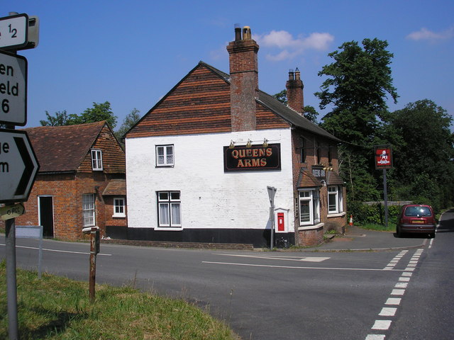
Queen's Arms, Cowden Pound

The Queens Arms is a Grade II listed public house at Hartfield Road, Cowden in Kent. It is on the Campaign for Real Ale's National Inventory of Historic...

Starborough Castle

Starborough Castle, known historically as Sterborough Castle, is a Neo-Gothic garden house of dressed sandstone near the eastern boundary of Surrey, built...

Cowden

Cowden () is a small village and civil parish in the Sevenoaks District of Kent, England. The parish is located on the northern slopes of the Weald, south...
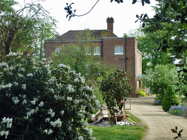
Greathed Manor

Greathed Manor, Dormansland, Surrey, is a Victorian country house. Designed by the architect Robert Kerr in 1862–8, it is a Grade II listed building....

Related Videos

Nearby Amenities

Located within 500m of 51.160889,0.062030825
The data included in this document is from www.openstreetmap.org. The data is made available under ODbL.

Have you been to Ash Plantation?

Leave your review of Ash Plantation below (or comments, questions and feedback).