Furze Wood
Wood, Forest in Surrey Tandridge
England
Furze Wood

Furze Wood is a beautiful and serene woodland located in Surrey, England. Spread across an area of approximately 100 acres, this woodland is known for its lush greenery, diverse flora, and tranquil atmosphere. It is situated in the southern part of Surrey, near the village of Chobham.
The woodland is primarily composed of various species of trees, including oak, birch, beech, and pine. The dense canopy formed by these trees provides a cool and shaded environment, making it a perfect retreat for nature enthusiasts and hikers. The forest floor is covered with a variety of wildflowers, ferns, and mosses, creating a vibrant and colorful landscape.
Furze Wood is home to a wide range of wildlife, making it a popular spot for birdwatching and nature observation. Visitors may spot species such as woodpeckers, owls, deer, and various small mammals. The woodland also acts as a haven for rare and endangered species, contributing to the biodiversity of the area.
There are well-maintained walking trails that meander through the woodland, allowing visitors to explore its beauty at their own pace. These trails are suitable for all levels of fitness, making it an ideal location for a leisurely stroll or a more vigorous hike. The woodland is also equipped with picnic areas and benches, providing a perfect spot to relax and immerse oneself in nature.
Furze Wood is open to the public year-round, and its natural beauty and peaceful ambiance make it a popular destination for nature lovers, families, and individuals seeking a tranquil escape from the hustle and bustle of everyday life.
If you have any feedback on the listing, please let us know in the comments section below.
Furze Wood Images
Images are sourced within 2km of 51.176061/0.012991191 or Grid Reference TQ4043. Thanks to Geograph Open Source API. All images are credited.


Furze Wood is located at Grid Ref: TQ4043 (Lat: 51.176061, Lng: 0.012991191)
Administrative County: Surrey
District: Tandridge
Police Authority: Surrey
What 3 Words
///town.fact.matter. Near Lingfield, Surrey
Nearby Locations
Related Wikis

Lingfield College
Lingfield College is a private day school situated in Lingfield in the English county of Surrey, for pupils aged six months to eighteen years old. It was...

Dormansland, Surrey
Dormansland is a large village and civil parish with a low population approximately one mile south of Lingfield in Surrey, England. It was founded in the...

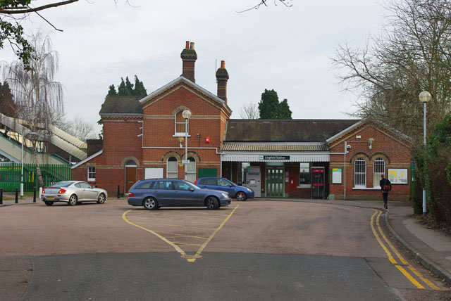
Lingfield railway station
Lingfield railway station is on the East Grinstead branch of the Oxted line in southern England and serves Lingfield in Surrey. It is 26 miles 23 chains...

Lingfield Park Racecourse
Lingfield Park Racecourse (commonly referred to as Lingfield) is a horse racing course at Lingfield in Surrey, United Kingdom. It is owned by the ARC Racing...

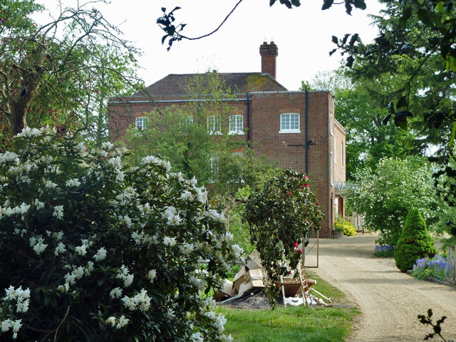
Greathed Manor
Greathed Manor, Dormansland, Surrey, is a Victorian country house. Designed by the architect Robert Kerr in 1862–8, it is a Grade II listed building....
Starborough Castle
Starborough Castle, known historically as Sterborough Castle, is a Neo-Gothic garden house of dressed sandstone near the eastern boundary of Surrey, built...

Centenary Fields
Centenary Fields is a 4.2-hectare (10-acre) Local Nature Reserve in Lingfield in Surrey. It is owned by Lingfield Parish Council and managed by Lingfield...

Haxted Watermill
Haxted Watermill is a much-restored Grade II listed watermill in Surrey, England, close to the border with Kent, and is powered by the River Eden. ��2...
Nearby Amenities
Located within 500m of 51.176061,0.012991191Have you been to Furze Wood?
Leave your review of Furze Wood below (or comments, questions and feedback).