Frith Wood

Wood, Forest in Surrey Tandridge

England

Frith Wood

Holt Wood, Chelsham (2) Plenty of oaks in this woodland.
Holt Wood, Chelsham (2) Credit: Stephen Richards

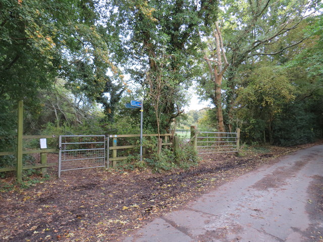
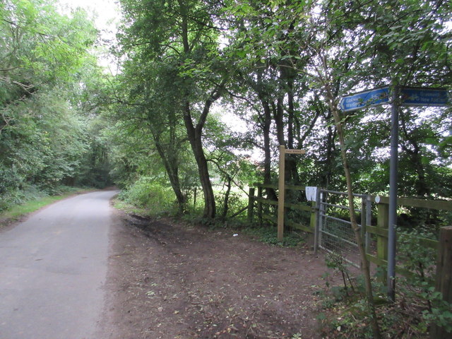
Frith Wood, located in Surrey, England, is a picturesque woodland that spans approximately 74 acres. It is nestled within the beautiful Surrey Hills Area of Outstanding Natural Beauty, attracting nature enthusiasts and walkers from near and far. The wood is renowned for its diverse flora and fauna, offering visitors a unique opportunity to explore a thriving ecosystem.

Comprising a mix of broadleaf and coniferous trees, Frith Wood boasts a rich variety of plant species. Ancient oak and beech trees dominate the landscape, their towering presence creating a sense of tranquility and awe. Bluebells carpet the forest floor during the spring, creating a breathtaking display of vibrant colors. In addition to the flora, the wood is home to a wide range of wildlife, including deer, foxes, and numerous bird species. Birdwatchers will delight in the chance to spot woodpeckers, nuthatches, and tawny owls among the dense foliage.

The wood offers several well-maintained walking trails, allowing visitors to fully immerse themselves in the natural beauty of the area. These paths wind through the wood, providing opportunities for exploration and discovery. Additionally, there are designated areas for picnicking, where visitors can relax and enjoy the peaceful surroundings.

Frith Wood's accessibility is another draw for visitors. Located near the village of Coldharbour, it is easily reachable by car or public transportation. The wood offers ample parking facilities and is well-connected to nearby towns and cities.

Overall, Frith Wood is a remarkable natural gem, providing a haven for both nature lovers and those seeking a tranquil escape from the bustle of everyday life.

If you have any feedback on the listing, please let us know in the comments section below.

Frith Wood Images

Images are sourced within 2km of 51.336936/-0.029227642 or Grid Reference TQ3761. Thanks to Geograph Open Source API. All images are credited.

Holt Wood, Chelsham (2) Plenty of oaks in this woodland.
Holt Wood, Chelsham (2)
Plenty of oaks in this woodland.
Oak, Chelsham Splendidly intricate and convoluted branches of one of many oaks in Holt Wood.
Oak, Chelsham
Splendidly intricate and convoluted branches of one of many oaks in Holt Wood.
A study in brown A lone walker crosses a ploughed field following footpath 587, or actually the straight line version customarily used - the legal line bends somewhat across the field for no obvious reason.
A study in brown
A lone walker crosses a ploughed field following footpath 587, or actually the straight line version customarily used - the legal line bends somewhat across the field for no obvious reason.
The Vanguard Way approaching Farleigh Church Ian Nairn in 'The Buildings of England: Surrey' says of Farleigh - "Tiny hamlet on the North Downs, quite unspoilt - almost the most rural in Surrey. This extraordinary place is four miles from the centre of Croydon, eleven from the Isle of Dogs, and almost within sight of some of the worst sprawl in the country at New Addington." St Mary's Church is "as surprising a survival for Surrey as the village: Simple village-Norman, fairly gently restored, with new chancel arch and simple new bell-turret. All stuccoed, and not a window later than 1250. Nave and chancel c.1100."

Basil Cracknell in 'A Portrait of Surrey' writes about Farleigh - "My favourite oasis is Farleigh, with its tiny Norman church of St Mary's, damaged badly by fire in 1964 but still standing, as it has stood for 850 years, the smallest and one of the oldest churches in Surrey." Farleigh resisted its incorporation into Greater London in the 1960s so fiercely that it won its case and stayed in Surrey. "The essence of Farleigh's claim was that it was not an oasis at all, since it did not lie within the desert but belonged to the green country beyond it. Farleigh they said was rural in character, had been rural for all its recorded history, and wanted to stay that way - and they won their case."

St Mary's Church is just beyond the trees in the centre with the church car park on this side of the trees - see <a title="https://www.geograph.org.uk/photo/5453495" href="https://www.geograph.org.uk/photo/5453495">Link</a>
The Vanguard Way approaching Farleigh Church
Ian Nairn in 'The Buildings of England: Surrey' says of Farleigh - "Tiny hamlet on the North Downs, quite unspoilt - almost the most rural in Surrey. This extraordinary place is four miles from the centre of Croydon, eleven from the Isle of Dogs, and almost within sight of some of the worst sprawl in the country at New Addington." St Mary's Church is "as surprising a survival for Surrey as the village: Simple village-Norman, fairly gently restored, with new chancel arch and simple new bell-turret. All stuccoed, and not a window later than 1250. Nave and chancel c.1100." Basil Cracknell in 'A Portrait of Surrey' writes about Farleigh - "My favourite oasis is Farleigh, with its tiny Norman church of St Mary's, damaged badly by fire in 1964 but still standing, as it has stood for 850 years, the smallest and one of the oldest churches in Surrey." Farleigh resisted its incorporation into Greater London in the 1960s so fiercely that it won its case and stayed in Surrey. "The essence of Farleigh's claim was that it was not an oasis at all, since it did not lie within the desert but belonged to the green country beyond it. Farleigh they said was rural in character, had been rural for all its recorded history, and wanted to stay that way - and they won their case." St Mary's Church is just beyond the trees in the centre with the church car park on this side of the trees - see Link
Farleigh Church seen from Greatpark Wood Ian Nairn in 'The Buildings of England: Surrey' says of Farleigh - "Tiny hamlet on the North Downs, quite unspoilt - almost the most rural in Surrey. This extraordinary place is four miles from the centre of Croydon, eleven from the Isle of Dogs, and almost within sight of some of the worst sprawl in the country at New Addington." St Mary's Church is "as surprising a survival for Surrey as the village: Simple village-Norman, fairly gently restored, with new chancel arch and simple new bell-turret. All stuccoed, and not a window later than 1250. Nave and chancel c.1100."

Basil Cracknell in 'A Portrait of Surrey' writes about Farleigh - "My favourite oasis is Farleigh, with its tiny Norman church of St Mary's, damaged badly by fire in 1964 but still standing, as it has stood for 850 years, the smallest and one of the oldest churches in Surrey." Farleigh resisted its incorporation into Greater London in the 1960s so fiercely that it won its case and stayed in Surrey. "The essence of Farleigh's claim was that it was not an oasis at all, since it did not lie within the desert but belonged to the green country beyond it. Farleigh they said was rural in character, had been rural for all its recorded history, and wanted to stay that way - and they won their case."

St Mary's Church can just be seen above the trees in the centre with the church car park on this side of the trees beyond the horses - see <a title="https://www.geograph.org.uk/photo/5453495" href="https://www.geograph.org.uk/photo/5453495">Link</a>  The Vanguard Way is just the other side of the fence on the left - see <a title="https://www.geograph.org.uk/photo/5453510" href="https://www.geograph.org.uk/photo/5453510">Link</a>
Farleigh Church seen from Greatpark Wood
Ian Nairn in 'The Buildings of England: Surrey' says of Farleigh - "Tiny hamlet on the North Downs, quite unspoilt - almost the most rural in Surrey. This extraordinary place is four miles from the centre of Croydon, eleven from the Isle of Dogs, and almost within sight of some of the worst sprawl in the country at New Addington." St Mary's Church is "as surprising a survival for Surrey as the village: Simple village-Norman, fairly gently restored, with new chancel arch and simple new bell-turret. All stuccoed, and not a window later than 1250. Nave and chancel c.1100." Basil Cracknell in 'A Portrait of Surrey' writes about Farleigh - "My favourite oasis is Farleigh, with its tiny Norman church of St Mary's, damaged badly by fire in 1964 but still standing, as it has stood for 850 years, the smallest and one of the oldest churches in Surrey." Farleigh resisted its incorporation into Greater London in the 1960s so fiercely that it won its case and stayed in Surrey. "The essence of Farleigh's claim was that it was not an oasis at all, since it did not lie within the desert but belonged to the green country beyond it. Farleigh they said was rural in character, had been rural for all its recorded history, and wanted to stay that way - and they won their case." St Mary's Church can just be seen above the trees in the centre with the church car park on this side of the trees beyond the horses - see Link The Vanguard Way is just the other side of the fence on the left - see Link
Scotshall Lane, near Warlingham Scotshall Lane is a minor lane through countryside in north-east Surrey.  National Cycle Network route 21 turns off onto a track to the left, as indicated by the blue signs.
Scotshall Lane, near Warlingham
Scotshall Lane is a minor lane through countryside in north-east Surrey. National Cycle Network route 21 turns off onto a track to the left, as indicated by the blue signs.
Farleigh Court Road, near Warlingham Farleigh Court Road is a narrow lane through countryside in north east Surrey.

The small blue sign attached to a tree to the left of the road indicates the route of National Cycle Network route 21.
Farleigh Court Road, near Warlingham
Farleigh Court Road is a narrow lane through countryside in north east Surrey. The small blue sign attached to a tree to the left of the road indicates the route of National Cycle Network route 21.
NCN21 near Warlingham This bridleway in Surrey countryside forms part of the route of National Cycle Network route 21
NCN21 near Warlingham
This bridleway in Surrey countryside forms part of the route of National Cycle Network route 21
Bridleway and footpath junction in Greatpark Wood A bridleway heads left towards Church Lane, near Chelsham. 
A footpath leads right towards Ledgers Lane, Chelsham.
Bridleway and footpath junction in Greatpark Wood
A bridleway heads left towards Church Lane, near Chelsham. A footpath leads right towards Ledgers Lane, Chelsham.
Footpath beside Greatpark Wood A path leads from Farleigh Court Road beside the wood towards Harrow Road near Chelsham.
Footpath beside Greatpark Wood
A path leads from Farleigh Court Road beside the wood towards Harrow Road near Chelsham.
Footpath beside Chelsham Tower Estate A path leads from Farleigh Court Road beside Greatpark Wood towards Harrow Road near Chelsham.
Footpath beside Chelsham Tower Estate
A path leads from Farleigh Court Road beside Greatpark Wood towards Harrow Road near Chelsham.
Gates to Warlingham Park Hospital Cemetery As seen from Greatpark Housing estate (built on the disused hospital).
The plaque on the iron gates reads "Croydon Mental Hospital From 1937 Warlingham Park Hospital  1903 - 1999 Great Park Wood Cemetery 1903 - 1960"
Gates to Warlingham Park Hospital Cemetery
As seen from Greatpark Housing estate (built on the disused hospital). The plaque on the iron gates reads "Croydon Mental Hospital From 1937 Warlingham Park Hospital 1903 - 1999 Great Park Wood Cemetery 1903 - 1960"
Footpath to Littlepark Wood A path leads across a field near Farleigh Court towards the wood and onwards to Harrow Road, Chelsham.
Footpath to Littlepark Wood
A path leads across a field near Farleigh Court towards the wood and onwards to Harrow Road, Chelsham.
Hayturner near Farleigh Court As seen from a bridleway to the court.

In the background are farmhouses on Farleigh Court Road.

This type of turner is a Vicon acrobat. In america they are known as Hay Tedders.
See <span class="nowrap"><a title="http://en.wikipedia.org/wiki/Tedder_(machine)" rel="nofollow ugc noopener" href="http://en.wikipedia.org/wiki/Tedder_(machine)">Link</a><img style="margin-left:2px;" alt="External link" title="External link - shift click to open in new window" src="https://s1.geograph.org.uk/img/external.png" width="10" height="10"/></span> for more details
Hayturner near Farleigh Court
As seen from a bridleway to the court. In the background are farmhouses on Farleigh Court Road. This type of turner is a Vicon acrobat. In america they are known as Hay Tedders. See LinkExternal link for more details
Bridleway to Farleigh Court The Vanguard Way (long distance path) leads from Chelsham towards Farleigh via bridleway from Greatpark Wood.
Bridleway to Farleigh Court
The Vanguard Way (long distance path) leads from Chelsham towards Farleigh via bridleway from Greatpark Wood.
Bridleway to Fickleshole This wooded track leads from Scotshall Lane towards Ficklesole Farm on Fairchildes Road.

The track is also known as High Hill road, it is also used by the long distance cyclepath Route 11 heading towards New Addington. 

It looks flat but after a short section, there is a steep climb up to the farm.
Bridleway to Fickleshole
This wooded track leads from Scotshall Lane towards Ficklesole Farm on Fairchildes Road. The track is also known as High Hill road, it is also used by the long distance cyclepath Route 11 heading towards New Addington. It looks flat but after a short section, there is a steep climb up to the farm.
Cycle Route 21 meets Scotshall Lane The long distance cyclepath heads right along a bridleway (called High Hill Road) towards Fickleshole Farm. 

It also heads along the narrow lane for a short distance before passing through Holt Wood (on the left) towards Chelsham.
Cycle Route 21 meets Scotshall Lane
The long distance cyclepath heads right along a bridleway (called High Hill Road) towards Fickleshole Farm. It also heads along the narrow lane for a short distance before passing through Holt Wood (on the left) towards Chelsham.
Cycle Route 21 leaves Scotshall Lane The long distance cyclepath heads from Chelsham via the lane, before heading left along a bridleway (called High Hill Road) towards Fickleshole Farm.
Cycle Route 21 leaves Scotshall Lane
The long distance cyclepath heads from Chelsham via the lane, before heading left along a bridleway (called High Hill Road) towards Fickleshole Farm.
Show me another place!

Frith Wood is located at Grid Ref: TQ3761 (Lat: 51.336936, Lng: -0.029227642)

Administrative County: Surrey

District: Tandridge

Police Authority: Surrey

What 3 Words

///vent.bolts.vague. Near West Wickham, London

Related Wikis

Hutchinson's Bank

Hutchinson's Bank is 21.8 hectare Local Nature Reserve and Site of Metropolitan Importance for Nature Conservation in New Addington in the London Borough...

New Addington tram stop

New Addington is a terminal tram stop serving the centre of New Addington, in the London Borough of Croydon, in the southern suburbs of London. The tram...

New Addington

New Addington is an area of South London, England, within the London Borough of Croydon. It is located 5 miles south east of Croydon and is adjacent to...

Forestdale, London

Forestdale is a residential neighbourhood of southeast London in the London Borough of Croydon. It is sometimes considered to be part of Addington, its...

New Addington Library

New Addington Library is a public library in New Addington, South London. It stands in the London Borough of Croydon and is part of the Croydon Libraries...

King Henry's Drive tram stop

King Henry's Drive tram stop is a light rail stop serving the Betchworth Way residential area of New Addington, in the London Borough of Croydon in the...

Selsdon Wood

Selsdon Wood is a woodland area located in the London Borough of Croydon. The park is owned by the National Trust but managed by the London Borough of...

Farleigh, Surrey

Farleigh is a village and former civil parish, now in the parish of Chelsham and Farleigh in the Tandridge district of Surrey, England. It is located in...

Have you been to Frith Wood?

Leave your review of Frith Wood below (or comments, questions and feedback).