Dialbank Wood

Wood, Forest in Surrey Tandridge

England

Dialbank Wood

A22 at Caterham Going south and nearing access to the southern M25 London orbital motorway
A22 at Caterham Credit: Nigel Freeman

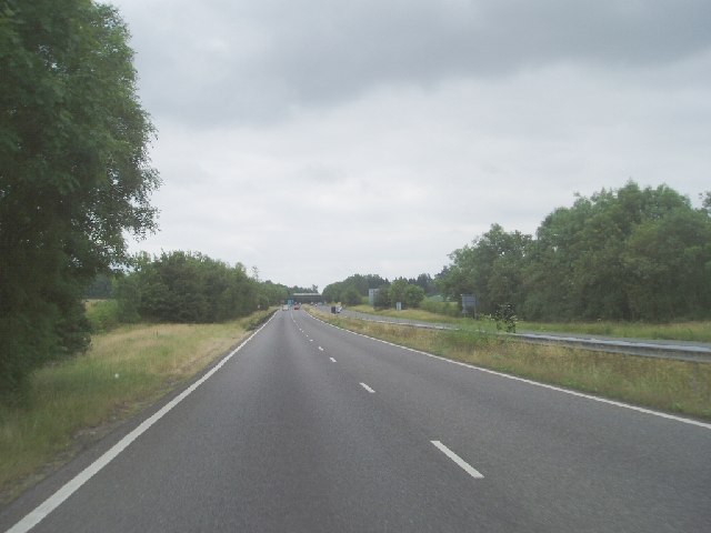
Dialbank Wood is a picturesque woodland located in the county of Surrey, England. Situated near the village of Dial Post, this charming forest covers an area of approximately 20 hectares. It is well-known for its natural beauty and tranquil atmosphere, attracting both locals and tourists alike.

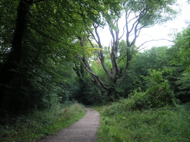
The wood is predominantly made up of a mixture of broadleaf trees, including oak, beech, and ash. These towering trees provide a dense canopy that filters sunlight, creating a cool and shaded environment below. The forest floor is carpeted with a variety of wildflowers, ferns, and mosses, adding to the area's enchanting appeal.

Dialbank Wood is home to a diverse range of wildlife, making it a haven for nature enthusiasts. Visitors may be lucky enough to spot deer, badgers, foxes, and a wide array of bird species such as woodpeckers, owls, and jays. The wood's secluded location ensures a peaceful and undisturbed habitat for these creatures.

Well-maintained footpaths meander through the wood, allowing visitors to explore its beauty at their own pace. These paths lead to hidden clearings and viewpoints, offering breathtaking vistas of the surrounding countryside. There are also designated picnic areas, providing the perfect spot to relax and enjoy a meal amidst the tranquility of nature.

Dialbank Wood is a popular destination for outdoor activities such as walking, hiking, and birdwatching. It offers a serene escape from the hustle and bustle of everyday life, inviting visitors to reconnect with nature and enjoy the simple pleasures it has to offer.

If you have any feedback on the listing, please let us know in the comments section below.

Dialbank Wood Images

Images are sourced within 2km of 51.264841/-0.06485219 or Grid Reference TQ3553. Thanks to Geograph Open Source API. All images are credited.

A22 at Caterham Going south and nearing access to the southern M25 London orbital motorway
A22 at Caterham
Going south and nearing access to the southern M25 London orbital motorway
A22 Godstone Bypass This road was built to relieve the traffic through the picturesque village of Godstone
A22 Godstone Bypass
This road was built to relieve the traffic through the picturesque village of Godstone
Caterham School Caterham prep and senior school, founded in 1811, provides co-educational schooling from the age of 3 to 18. The current school is a merger of two schools - Caterham Boys' school, founded in 1811, and Eothen girls' school, founded in 1892.
Caterham School
Caterham prep and senior school, founded in 1811, provides co-educational schooling from the age of 3 to 18. The current school is a merger of two schools - Caterham Boys' school, founded in 1811, and Eothen girls' school, founded in 1892.
Water Tower on Gravelly Hill One of many water towers that can be seen on the North Downs. Most as this one have found a new use in recent times as mobile phone masts.
Water Tower on Gravelly Hill
One of many water towers that can be seen on the North Downs. Most as this one have found a new use in recent times as mobile phone masts.
View Point on the North Downs  Near Caterham Some stunning views are seen off the edge of the North Downs from this viewing area.  The line of trucks that can be seen in the middle distance is the M25, snarled up yet again because of an accident.
View Point on the North Downs Near Caterham
Some stunning views are seen off the edge of the North Downs from this viewing area. The line of trucks that can be seen in the middle distance is the M25, snarled up yet again because of an accident.
Enjoying the View, Near Caterham A couple enjoy the view from this viewpoint near Caterham.
Enjoying the View, Near Caterham
A couple enjoy the view from this viewpoint near Caterham.
Tumuli in a field A short footpath near the village of Godstone, next to some fields containing tumuli.
Tumuli in a field
A short footpath near the village of Godstone, next to some fields containing tumuli.
North Downs Way near A22 Tupwood Lane is in the foreground. To the left, the path leads eastwards across the footbridge depicted in the view of the A22 at this point.
North Downs Way near A22
Tupwood Lane is in the foreground. To the left, the path leads eastwards across the footbridge depicted in the view of the A22 at this point.
A22 Caterham Bypass junction with B2030 Godstone Road
Marlesdon Park footpath A public footpath that runs through Marlesdon Park.  Marlesdon Park was a barren stretch of land until Sir Robert Claydon, the Lord Mayer of London (1679-80) built his home and estate there, planting many trees.
Marlesdon Park footpath
A public footpath that runs through Marlesdon Park. Marlesdon Park was a barren stretch of land until Sir Robert Claydon, the Lord Mayer of London (1679-80) built his home and estate there, planting many trees.
Field, next to M25 This field next to the M25 has numerous curious looking pipes sticking vertically out of it.  On occasion, surveyors have been seen taking measurements around the pipes.  The pipes were inserted a few years ago as countermeasures when a serious landslip caused the field to subside substantially, partially obscuring the M25.
Field, next to M25
This field next to the M25 has numerous curious looking pipes sticking vertically out of it. On occasion, surveyors have been seen taking measurements around the pipes. The pipes were inserted a few years ago as countermeasures when a serious landslip caused the field to subside substantially, partially obscuring the M25.
Fishing Lake, near Godstone A small fishing lake next to the M25 (background) and Godstone Vineyard
Fishing Lake, near Godstone
A small fishing lake next to the M25 (background) and Godstone Vineyard
Field boundary near Godstone This field boundary near Godstone is guarded with a high security fence.  Behind the fence is Godstone reservoir which has steep banks, hence the protection.
Field boundary near Godstone
This field boundary near Godstone is guarded with a high security fence. Behind the fence is Godstone reservoir which has steep banks, hence the protection.
Narrow Bridge over M25 This narrow bridge over the M25 serves some farms situated at the edge of the North Downs.
Narrow Bridge over M25
This narrow bridge over the M25 serves some farms situated at the edge of the North Downs.
Convent of the Sacred Heart, Marden Park, Woldingham, Surrey Viewed looking northwards from the public bridleway
Convent of the Sacred Heart, Marden Park, Woldingham, Surrey
Viewed looking northwards from the public bridleway
Millennium Centre, Woldingham School, Surrey Just a small part of this large progressive Roman Catholic girls' school
Millennium Centre, Woldingham School, Surrey
Just a small part of this large progressive Roman Catholic girls' school
Godstone Village Pond Looking across the village pond to the White Hart. The village is quiet as it is bypassed to the east by the A22.
Godstone Village Pond
Looking across the village pond to the White Hart. The village is quiet as it is bypassed to the east by the A22.
Hockey training at Caterham School All-weather pitch and School's Sports Centre beyond. Looking West from Harestone Valley Road. Main school buildings are other side of road, directly opposite.
Hockey training at Caterham School
All-weather pitch and School's Sports Centre beyond. Looking West from Harestone Valley Road. Main school buildings are other side of road, directly opposite.
Show me another place!

Dialbank Wood is located at Grid Ref: TQ3553 (Lat: 51.264841, Lng: -0.06485219)

Administrative County: Surrey

District: Tandridge

Police Authority: Surrey

What 3 Words

///trader.wink.stars. Near Godstone, Surrey

Related Wikis

Woldingham School

Woldingham School is an independent boarding and day school for girls, located in the former Marden Park of 700 acres (280 ha) outside the village of Woldingham...

A25 road

The A25 road is an east–west main road in the South-East of England. Its carries traffic east from Guildford, Surrey, eastward through Surrey and into...

Caterham School

Caterham School is an independent co-educational day and boarding school located in Caterham, Surrey and a member of the Headmasters' and Headmistresses...

1929 Luft Hansa Junkers G 24 crash

The 1929 Luft Hansa Junkers G.24 crash occurred on 6 November 1929 when a Junkers G 24 of Luft Hansa crashed at Godstone, Surrey, United Kingdom while...

Bay Pond

Bay Pond is a 7-hectare (17-acre) nature reserve in Godstone in Surrey. It is managed by the Surrey Wildlife Trust. It is part of Godstone Ponds Site...

Godstone

Godstone is a village and civil parish in the Tandridge District of Surrey, England. It is 6 miles (9.7 km) east of Reigate, 3 miles (4.8 km) west of Oxted...

Tandridge Hundred

Tandridge Hundred was a hundred in Surrey, England. It comprised areas in the Tandridge District, the easternmost part of the county, bordering Kent, West...

Woldingham and Oxted Downs

Woldingham and Oxted Downs is a 128.4-hectare (317-acre) biological Site of Special Scientific Interest east of Caterham in Surrey.This sloping site on...

Related Videos

The Secrets of North Downs Revealed: Explore Marden Park and Greensand Way

Join us on a thrilling hike through Marden Park and Greensand Way in the North Downs of England, and experience the ...

Marden Park And Greensand Way The North Downs | | 🇬🇧 Hiking UK | England Drone 4k | Saturday Walk

Close to London, this walk combines stretches of both The North Downs Way, and the Greensand Way. Main Walk: 16¾ km (10.4 ...

North Downs Way: Caterham to Knockholt | Essential Backpacking Gear Guide | UK Hiking Adventures 🇬🇧

Venture with us along the North Downs Way, from Caterham to Knockholt, as we traverse stunning landscapes, historic landmarks ...

Nearby Amenities

Located within 500m of 51.264841,-0.06485219
Bus Stop
Quarry Road
Naptan AtcoCode: 40004410224A
Naptan Bearing: N
Naptan CommonName: Quarry Road
Naptan Indicator: Opp
Naptan Landmark: Farm Lane
Naptan NaptanCode: surdpmdt
Naptan Street: Godstone Hill
Naptan Verified: no
Public Transport: platform
Shelter: no
Source: naptan_import
Tactile Paving: no
Wheelchair: yes
Lat/Long: 51.2616407/-0.0662186
Bus Stop
Quarry Road
Naptan AtcoCode: 40004410224B
Naptan Bearing: S
Naptan CommonName: Quarry Road
Naptan Indicator: adj
Naptan Landmark: Quarry Road
Naptan NaptanCode: surdpmdw
Naptan Street: Godstone Hill
Naptan Verified: no
Public Transport: platform
Shelter: no
Source: naptan_import
Tactile Paving: no
Wheelchair: yes
Lat/Long: 51.2605251/-0.0646514
Post Box
Ref: RH9 279
Source: Photo P142-0062
Lat/Long: 51.2644677/-0.0636528
Barrier: stile
Lat/Long: 51.2618561/-0.0699253
Information: board
Tourism: information
Lat/Long: 51.2666468/-0.0666046
Winders Hill
Natural: peak
Lat/Long: 51.2660468/-0.0595133
The Devils Hole
Natural: cave_entrance
Lat/Long: 51.2662518/-0.0626999
Barrier: stile
Lat/Long: 51.2663728/-0.0595587
Traffic Sign: variable_message
Lat/Long: 51.2621767/-0.0667763
Godstone Mines
Natural: cave_entrance
Website: https://wealdencaving.org.uk/website2/
Lat/Long: 51.2645935/-0.0652045
Traffic Mirror
Direction: 320
Lat/Long: 51.2687356/-0.066623
Give Way
Direction: backward
Lat/Long: 51.2611561/-0.065339
The data included in this document is from www.openstreetmap.org. The data is made available under ODbL.

Have you been to Dialbank Wood?

Leave your review of Dialbank Wood below (or comments, questions and feedback).