Asylum Wood

Wood, Forest in Sussex Lewes

England

Asylum Wood

Haywards Heath town sign Town sign among spring bedding at the junction of South Road, Church Road and Perrymount Road.  The sign depicts a Royalist and Parliamentarian, commemorating the Battle of Muster Green which took place here in 1642.
Haywards Heath town sign Credit: Ian Capper

Asylum Wood is a picturesque woodland located in Sussex, England. This enchanting forest spans over a vast area of approximately 50 acres, offering visitors a tranquil and serene environment to explore. It is nestled amidst the South Downs National Park, adding to its natural beauty and allure.

The woodland features a diverse range of trees, including oak, beech, and ash, which form a dense canopy overhead, creating a cool and inviting atmosphere. The forest floor is covered with a rich carpet of wildflowers and ferns, providing a vibrant burst of color throughout the seasons.

Due to its untouched and secluded nature, Asylum Wood is a haven for wildlife. It serves as a sanctuary for a variety of bird species, such as woodpeckers, owls, and finches. Additionally, the woodland is home to various mammals, including deer, foxes, and badgers.

The wood is crisscrossed by a network of well-maintained footpaths that guide visitors through its enchanting landscape. These paths lead to hidden clearings and viewpoints, allowing visitors to immerse themselves in the natural beauty of the surroundings.

Asylum Wood holds historical significance as well. The name "Asylum" is believed to have originated from the area's history as a retreat for mental health patients during the late 19th century. Although the asylum no longer exists, the wood has retained its name, serving as a reminder of its past.

Overall, Asylum Wood offers a captivating and peaceful escape from the bustling city life, providing an opportunity to reconnect with nature and enjoy the beauty of Sussex's countryside.

If you have any feedback on the listing, please let us know in the comments section below.

Asylum Wood Images

Images are sourced within 2km of 50.988075/-0.084906158 or Grid Reference TQ3422. Thanks to Geograph Open Source API. All images are credited.

Haywards Heath town sign Town sign among spring bedding at the junction of South Road, Church Road and Perrymount Road.  The sign depicts a Royalist and Parliamentarian, commemorating the Battle of Muster Green which took place here in 1642.
Haywards Heath town sign
Town sign among spring bedding at the junction of South Road, Church Road and Perrymount Road. The sign depicts a Royalist and Parliamentarian, commemorating the Battle of Muster Green which took place here in 1642.
The White House
The White House
Gates to Wivelsfield Hall
Slugwash Lane The Sussex Border Path is a footpath route nearly 150 miles long around the inland boundary of the county of Sussex. The county owes its origins to the kingdom of the South Saxons and can claim to have one of the longest inland county boundaries from Emsworth to Rye. The route was devised in 1983 and is well signed along most of the route. Website <span class="nowrap"><a title="http://www.sussexborderpath.co.uk/" rel="nofollow ugc noopener" href="http://www.sussexborderpath.co.uk/">Link</a><img style="margin-left:2px;" alt="External link" title="External link - shift click to open in new window" src="https://s1.geograph.org.uk/img/external.png" width="10" height="10"/></span> 
Map: <a title="https://www.geograph.org.uk/search.php?i=40140109&page=1&displayclass=map#i=40140109&page=1&displayclass=map&zoom=2&lat=51.03263&lon=-0.05427&layers=FTTB00000000000T" href="https://www.geograph.org.uk/search.php?i=40140109&page=1&displayclass=map#i=40140109&page=1&displayclass=map&zoom=2&lat=51.03263&lon=-0.05427&layers=FTTB00000000000T">Link</a>
Slugwash Lane
The Sussex Border Path is a footpath route nearly 150 miles long around the inland boundary of the county of Sussex. The county owes its origins to the kingdom of the South Saxons and can claim to have one of the longest inland county boundaries from Emsworth to Rye. The route was devised in 1983 and is well signed along most of the route. Website LinkExternal link Map: Link
Townings Place
Townings Place
Slugwash Lane
Slugwash Lane
Slugwash Lane The Sussex Border Path is a footpath route nearly 150 miles long around the inland boundary of the county of Sussex. The county owes its origins to the kingdom of the South Saxons and can claim to have one of the longest inland county boundaries from Emsworth to Rye. The route was devised in 1983 and is well signed along most of the route. Website <span class="nowrap"><a title="http://www.sussexborderpath.co.uk/" rel="nofollow ugc noopener" href="http://www.sussexborderpath.co.uk/">Link</a><img style="margin-left:2px;" alt="External link" title="External link - shift click to open in new window" src="https://s1.geograph.org.uk/img/external.png" width="10" height="10"/></span> 
Map: <a title="https://www.geograph.org.uk/search.php?i=40140109&page=1&displayclass=map#i=40140109&page=1&displayclass=map&zoom=2&lat=51.03263&lon=-0.05427&layers=FTTB00000000000T" href="https://www.geograph.org.uk/search.php?i=40140109&page=1&displayclass=map#i=40140109&page=1&displayclass=map&zoom=2&lat=51.03263&lon=-0.05427&layers=FTTB00000000000T">Link</a>
Slugwash Lane
The Sussex Border Path is a footpath route nearly 150 miles long around the inland boundary of the county of Sussex. The county owes its origins to the kingdom of the South Saxons and can claim to have one of the longest inland county boundaries from Emsworth to Rye. The route was devised in 1983 and is well signed along most of the route. Website LinkExternal link Map: Link
Maize by Slugwash Lane
Slugwash Lane
Slugwash Lane
Slugwash Lane The Sussex Border Path is a footpath route nearly 150 miles long around the inland boundary of the county of Sussex. The county owes its origins to the kingdom of the South Saxons and can claim to have one of the longest inland county boundaries from Emsworth to Rye. The route was devised in 1983 and is well signed along most of the route. Website <span class="nowrap"><a title="http://www.sussexborderpath.co.uk/" rel="nofollow ugc noopener" href="http://www.sussexborderpath.co.uk/">Link</a><img style="margin-left:2px;" alt="External link" title="External link - shift click to open in new window" src="https://s1.geograph.org.uk/img/external.png" width="10" height="10"/></span> 
Map: <a title="https://www.geograph.org.uk/search.php?i=40140109&page=1&displayclass=map#i=40140109&page=1&displayclass=map&zoom=2&lat=51.03263&lon=-0.05427&layers=FTTB00000000000T" href="https://www.geograph.org.uk/search.php?i=40140109&page=1&displayclass=map#i=40140109&page=1&displayclass=map&zoom=2&lat=51.03263&lon=-0.05427&layers=FTTB00000000000T">Link</a>
Slugwash Lane
The Sussex Border Path is a footpath route nearly 150 miles long around the inland boundary of the county of Sussex. The county owes its origins to the kingdom of the South Saxons and can claim to have one of the longest inland county boundaries from Emsworth to Rye. The route was devised in 1983 and is well signed along most of the route. Website LinkExternal link Map: Link
Cattle grazing
Cattle grazing
Moors Cottage
Moors Cottage
Ham Lane The Sussex Border Path is a footpath route nearly 150 miles long around the inland boundary of the county of Sussex. The county owes its origins to the kingdom of the South Saxons and can claim to have one of the longest inland county boundaries from Emsworth to Rye. The route was devised in 1983 and is well signed along most of the route. Website <span class="nowrap"><a title="http://www.sussexborderpath.co.uk/" rel="nofollow ugc noopener" href="http://www.sussexborderpath.co.uk/">Link</a><img style="margin-left:2px;" alt="External link" title="External link - shift click to open in new window" src="https://s1.geograph.org.uk/img/external.png" width="10" height="10"/></span> 
Map: <a title="https://www.geograph.org.uk/search.php?i=40140109&page=1&displayclass=map#i=40140109&page=1&displayclass=map&zoom=2&lat=51.03263&lon=-0.05427&layers=FTTB00000000000T" href="https://www.geograph.org.uk/search.php?i=40140109&page=1&displayclass=map#i=40140109&page=1&displayclass=map&zoom=2&lat=51.03263&lon=-0.05427&layers=FTTB00000000000T">Link</a>
Ham Lane
The Sussex Border Path is a footpath route nearly 150 miles long around the inland boundary of the county of Sussex. The county owes its origins to the kingdom of the South Saxons and can claim to have one of the longest inland county boundaries from Emsworth to Rye. The route was devised in 1983 and is well signed along most of the route. Website LinkExternal link Map: Link
Wooded pond
Wooded pond
Strood Wood
Strood Wood
Sussex Border Path, Strood Wood The Sussex Border Path is a footpath route nearly 150 miles long around the inland boundary of the county of Sussex. The county owes its origins to the kingdom of the South Saxons and can claim to have one of the longest inland county boundaries from Emsworth to Rye. The route was devised in 1983 and is well signed along most of the route. Website <span class="nowrap"><a title="http://www.sussexborderpath.co.uk/" rel="nofollow ugc noopener" href="http://www.sussexborderpath.co.uk/">Link</a><img style="margin-left:2px;" alt="External link" title="External link - shift click to open in new window" src="https://s1.geograph.org.uk/img/external.png" width="10" height="10"/></span> 
Map: <a title="https://www.geograph.org.uk/search.php?i=40140109&page=1&displayclass=map#i=40140109&page=1&displayclass=map&zoom=2&lat=51.03263&lon=-0.05427&layers=FTTB00000000000T" href="https://www.geograph.org.uk/search.php?i=40140109&page=1&displayclass=map#i=40140109&page=1&displayclass=map&zoom=2&lat=51.03263&lon=-0.05427&layers=FTTB00000000000T">Link</a>
Sussex Border Path, Strood Wood
The Sussex Border Path is a footpath route nearly 150 miles long around the inland boundary of the county of Sussex. The county owes its origins to the kingdom of the South Saxons and can claim to have one of the longest inland county boundaries from Emsworth to Rye. The route was devised in 1983 and is well signed along most of the route. Website LinkExternal link Map: Link
Sussex Border Path The Sussex Border Path is a footpath route nearly 150 miles long around the inland boundary of the county of Sussex. The county owes its origins to the kingdom of the South Saxons and can claim to have one of the longest inland county boundaries from Emsworth to Rye. The route was devised in 1983 and is well signed along most of the route. Website <span class="nowrap"><a title="http://www.sussexborderpath.co.uk/" rel="nofollow ugc noopener" href="http://www.sussexborderpath.co.uk/">Link</a><img style="margin-left:2px;" alt="External link" title="External link - shift click to open in new window" src="https://s1.geograph.org.uk/img/external.png" width="10" height="10"/></span> 
Map: <a title="https://www.geograph.org.uk/search.php?i=40140109&page=1&displayclass=map#i=40140109&page=1&displayclass=map&zoom=2&lat=51.03263&lon=-0.05427&layers=FTTB00000000000T" href="https://www.geograph.org.uk/search.php?i=40140109&page=1&displayclass=map#i=40140109&page=1&displayclass=map&zoom=2&lat=51.03263&lon=-0.05427&layers=FTTB00000000000T">Link</a>
Sussex Border Path
The Sussex Border Path is a footpath route nearly 150 miles long around the inland boundary of the county of Sussex. The county owes its origins to the kingdom of the South Saxons and can claim to have one of the longest inland county boundaries from Emsworth to Rye. The route was devised in 1983 and is well signed along most of the route. Website LinkExternal link Map: Link
Show me another place!

Asylum Wood is located at Grid Ref: TQ3422 (Lat: 50.988075, Lng: -0.084906158)

Administrative County: East Sussex

District: Lewes

Police Authority: Sussex

What 3 Words

///ready.swan.exact. Near Haywards Heath, West Sussex

Related Wikis

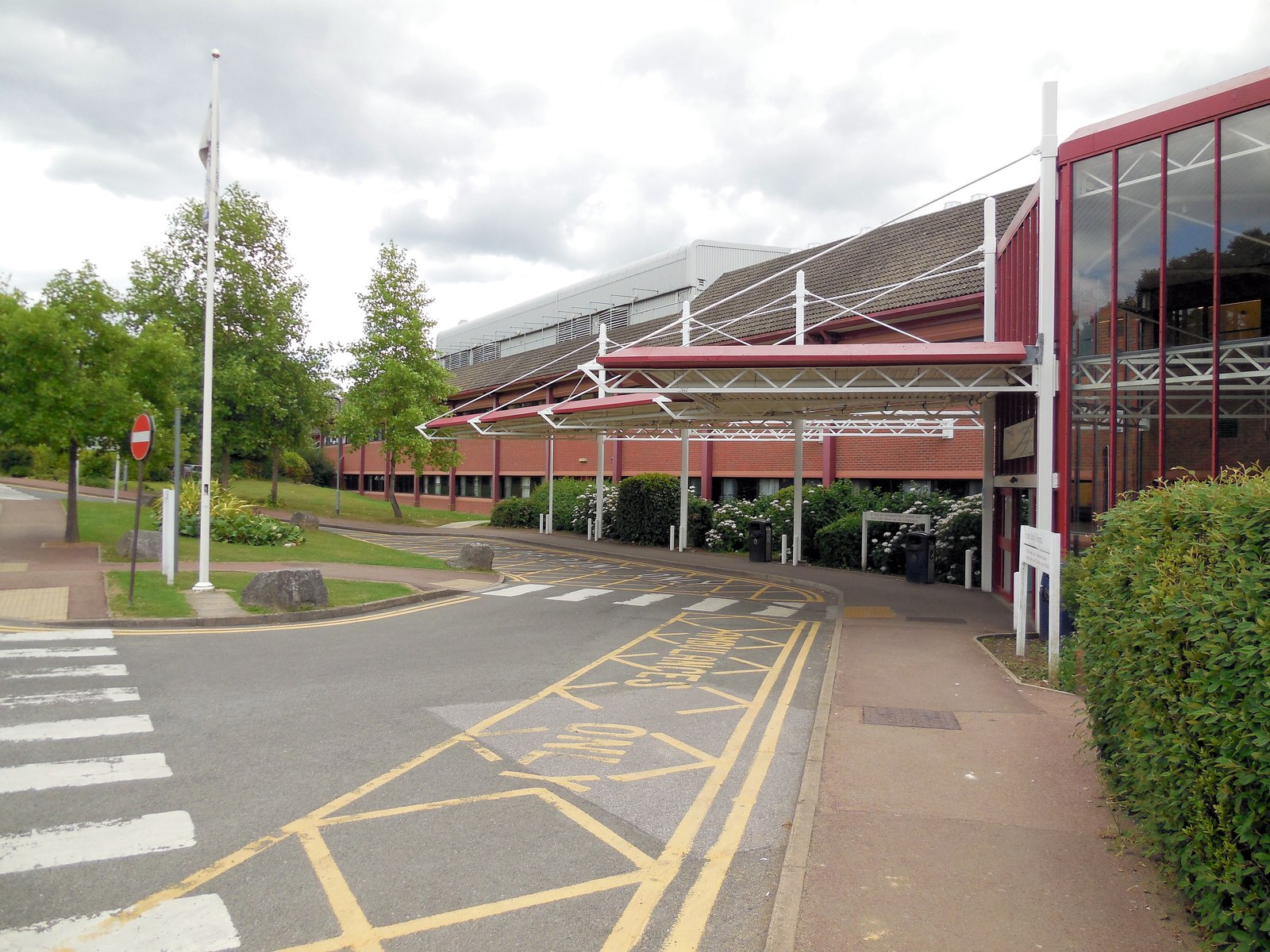
Princess Royal Hospital, Haywards Heath

The Princess Royal Hospital, also known as PRH, is an acute, teaching, general hospital located in Haywards Heath, West Sussex, England. It is the main...

Haywards Heath East (electoral division)

Haywards Heath East is an electoral division of West Sussex in the United Kingdom, and returns one member to sit on West Sussex County Council. == Extent... ==

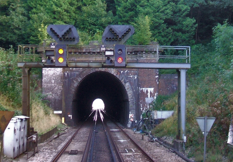
Haywards Heath Tunnel

Haywards Heath tunnel, also known as Folly Hill tunnel, is a railway tunnel on the Brighton Main Line between Haywards Heath and Wivelsfield. It is 249...

St Francis Rangers F.C.

St Francis Rangers F.C. is a football club based in Haywards Heath, England. They are currently members of the Southern Combination Division Two and play...

St Francis Hospital, Haywards Heath

St Francis Hospital was a mental health facility in Haywards Heath, West Sussex, England. The main building survives and is a Grade II listed building...

Jireh Chapel, Haywards Heath

The Jireh Chapel is a Strict Baptist place of worship in the town of Haywards Heath in the English county of West Sussex. The chapel was built in 1879...

Haywards Heath Town F.C.

Haywards Heath Town Football Club is a football club based in Haywards Heath, West Sussex, England. They are currently members of the Southern Combination...

Scrase Valley

The Scrase Valley is an 8-hectare (20-acre) Local Nature Reserve on the eastern outskirts of Haywards Heath in West Sussex. It is owned and managed by...

Nearby Amenities

Located within 500m of 50.988075,-0.084906158
Turning Circle
Lat/Long: 50.9898861/-0.0838121
Post Box
Brand: Royal Mail
Brand Wikidata: Q638098
Brand Wikipedia: en:Royal Mail
Operator: Royal Mail
Operator Wikidata: Q638098
Post Box Type: lamp
Ref: RH17 81D
Royal Cypher: EIIR
Royal Cypher Wikidata: Q33102113
Lat/Long: 50.9898373/-0.0881134
Crossing
Bicycle: yes
Crossing: unmarked
Crossing Markings: no
Kerb: lowered
Tactile Paving: yes
Lat/Long: 50.9918395/-0.0876243
Crossing
Lat/Long: 50.9886966/-0.0899149
Entrance: yes
Lat/Long: 50.9899607/-0.0901947
Accident and Emergency
Entrance: yes
Lat/Long: 50.9911386/-0.0892575
MRI Unit
Entrance: yes
Lat/Long: 50.9906525/-0.0889808
Bus Stop
Ridgeway
Bus: yes
Public Transport: stop_position
Lat/Long: 50.990049/-0.0823878
Bus Stop
Ashway
Bus: yes
Public Transport: stop_position
Lat/Long: 50.9885236/-0.081432
Crossing
Bicycle: yes
Crossing: unmarked
Crossing Markings: no
Kerb: lowered
Tactile Paving: yes
Lat/Long: 50.9915448/-0.0874021
Crossing
Bicycle: yes
Crossing: unmarked
Crossing Markings: no
Kerb: lowered
Tactile Paving: yes
Lat/Long: 50.9915587/-0.0875289
Crossing
Bicycle: yes
Crossing: unmarked
Crossing Markings: no
Kerb: lowered
Tactile Paving: yes
Lat/Long: 50.991773/-0.0876909
Crossing
Bicycle: yes
Crossing: unmarked
Crossing Markings: no
Kerb: lowered
Tactile Paving: yes
Lat/Long: 50.991853/-0.0872533
Crossing
Bicycle: yes
Crossing: unmarked
Crossing Markings: no
Kerb: lowered
Tactile Paving: yes
Lat/Long: 50.9917761/-0.0871892
Traffic Calming: island
Lat/Long: 50.9876239/-0.0915448
The data included in this document is from www.openstreetmap.org. The data is made available under ODbL.

Have you been to Asylum Wood?

Leave your review of Asylum Wood below (or comments, questions and feedback).