Aber-Giâr

Settlement in Carmarthenshire

Wales

Aber-Giâr

A485 through Aber Giar Approaching Norwood Gardens entrance
A485 through Aber Giar Credit: John Firth

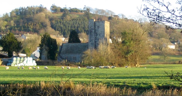
Aber-Giâr is a small village located in the county of Carmarthenshire, Wales. Situated in the picturesque Tywi Valley, Aber-Giâr is surrounded by rolling hills and beautiful countryside. The village is nestled on the banks of the River Tywi, which adds to its charm and tranquility.

Historically, Aber-Giâr was an important center for the wool industry in the 19th century. The village had several mills that processed the locally produced wool, which was then exported to various parts of the country. Today, remnants of this industrial past can still be seen in the form of old mills and buildings.

Aber-Giâr is a tight-knit community with a population of around 500 people. The village has a primary school, a community center, and a small number of shops and local businesses. The residents take great pride in their village and actively participate in community events and initiatives.

The surrounding area offers ample opportunities for outdoor activities and exploration. The nearby Brechfa Forest is a popular destination for hikers, mountain bikers, and nature enthusiasts. The forest is home to an extensive network of trails, offering stunning views and a chance to spot local wildlife.

For those interested in history and culture, Aber-Giâr is within easy reach of several notable landmarks. The National Botanic Garden of Wales and the historic town of Carmarthen are both a short drive away, providing visitors with a range of attractions and amenities.

Overall, Aber-Giâr is a charming village that offers a peaceful and idyllic setting, making it an ideal place to escape the hustle and bustle of modern life.

If you have any feedback on the listing, please let us know in the comments section below.

Aber-Giâr Images

Images are sourced within 2km of 52.045909/-4.184816 or Grid Reference SN5040. Thanks to Geograph Open Source API. All images are credited.

A485 through Aber Giar Approaching Norwood Gardens entrance
A485 through Aber Giar
Approaching Norwood Gardens entrance
Norwood Gardens entrance from A485
Ordnance Survey Pivot This OS pivot can be found on the milestone NW side of the road. It marks a point 176.311m above mean sea level. <a title="https://www.geograph.org.uk/photo/7400908" href="https://www.geograph.org.uk/photo/7400908">Link</a>
Ordnance Survey Pivot
This OS pivot can be found on the milestone NW side of the road. It marks a point 176.311m above mean sea level. Link
Milestone - Carmarthen 13 Badly leaning now. There is an Ordnance Survey pivot on the top of the stone. <a title="https://www.geograph.org.uk/photo/7400904" href="https://www.geograph.org.uk/photo/7400904">Link</a>
Milestone - Carmarthen 13
Badly leaning now. There is an Ordnance Survey pivot on the top of the stone. Link
Ordnance Survey Cut Mark This OS cut mark can be found on the roadside barn at Plasbach. It marks a point 168.589m above mean sea level.
Ordnance Survey Cut Mark
This OS cut mark can be found on the roadside barn at Plasbach. It marks a point 168.589m above mean sea level.
Ordnance Survey Cut Mark This OS cut mark can be found on the roadside barn at Ffynnon-ddrain. It marks a point 135.145m above mean sea level.
Ordnance Survey Cut Mark
This OS cut mark can be found on the roadside barn at Ffynnon-ddrain. It marks a point 135.145m above mean sea level.
Ordnance Survey Cut Mark This OS cut mark can be found on the gatepost north side of the road.
Ordnance Survey Cut Mark
This OS cut mark can be found on the gatepost north side of the road.
Ordnance Survey Cut Mark This OS cut mark can be found on the gatepost SE side of the road. It marks a point 110.341m above mean sea level.
Ordnance Survey Cut Mark
This OS cut mark can be found on the gatepost SE side of the road. It marks a point 110.341m above mean sea level.
Ordnance Survey Cut Mark This OS cut mark can be found on the SW abutment of the railway bridge. It marks a point 102.173m above mean sea level.
Ordnance Survey Cut Mark
This OS cut mark can be found on the SW abutment of the railway bridge. It marks a point 102.173m above mean sea level.
Castell Nonni An ancient motte.
Castell Nonni
An ancient motte.
Power lines
Power lines
Down the bridleway
Down the bridleway
Celtic Classics Classic car showroom.
Celtic Classics
Classic car showroom.
Field above Llanllwni On the slopes of Mynydd Llanllwni. Beyond, drizzle sweeps over the Teifi valley.
Field above Llanllwni
On the slopes of Mynydd Llanllwni. Beyond, drizzle sweeps over the Teifi valley.
The road to Llanllwni Common Climbing the lower slopes of Mynydd Llanllwni.
The road to Llanllwni Common
Climbing the lower slopes of Mynydd Llanllwni.
Old Milestone by the A485 in Llanllwni Milestone by the A485, in parish of Llanllwni (Carmarthenshire District), Llanllwni.

Inscription reads:-
Carmarthen
13
Lampeter
9 

Surveyed

Milestone Society National ID: CAM_CMLP13
Old Milestone by the A485 in Llanllwni
Milestone by the A485, in parish of Llanllwni (Carmarthenshire District), Llanllwni. Inscription reads:- Carmarthen 13 Lampeter 9 Surveyed Milestone Society National ID: CAM_CMLP13
Llwybr ar gomin / Path on a common Llwybr ar lethrau isaf Mynydd Llanllwni.

A path on the lower slopes of Mynydd Llanllwni (trans. St Llwni's parish mountain).
Llwybr ar gomin / Path on a common
Llwybr ar lethrau isaf Mynydd Llanllwni. A path on the lower slopes of Mynydd Llanllwni (trans. St Llwni's parish mountain).
Heol fynedfa / Access road Heol fynedfa a llwybr troed cyhoedus ar dir agored.

An access road and public footpath on open countryside.
Heol fynedfa / Access road
Heol fynedfa a llwybr troed cyhoedus ar dir agored. An access road and public footpath on open countryside.
Show me another place!

Aber-Giâr is located at Grid Ref: SN5040 (Lat: 52.045909, Lng: -4.184816)

Unitary Authority: Carmarthenshire

Police Authority: Dyfed Powys

Also known as: Abergiâr

What 3 Words

///kindness.chess.removing. Near Pencader, Carmarthenshire

Nearby Locations

Abergiâr Aber-Giâr

Related Wikis

Aber-giar

Aber-giar (Welsh: Abergiâr) is a village in the community of Llanllwni in Carmarthenshire, Wales.

Llanllwni

Llanllwni is a village and community in Carmarthenshire, Wales, on the A485 road south-west of Llanybydder. To the south lies the mountain, Mynydd Llanllwni...

Highmead

Highmead is a small village in the community of Llanwenog, Ceredigion, Wales, which is 59.2 miles (95.3 km) from Cardiff and 177.7 miles (286 km) from...

Rhuddlan, Ceredigion

Rhuddlan, Ceredigion is a small village in the community of Llanwenog, Ceredigion, Wales. Rhuddlan is represented in the Senedd by Elin Jones (Plaid Cymru...

Maesycrugiau railway station

Maesycrugiau railway station also Maes-y-crugiau railway station served the hamlet and rural locale of Maesycrugiau near Llanllwni on the Carmarthen Aberystwyth...

Llanybydder

Llanybydder (Welsh pronunciation: [ˌɬanəˈbəðɛr], sometimes formerly spelt Llanybyther) is a market town and community straddling the River Teifi in Carmarthenshire...

Blaenborthyn

Blaenborthyn is a small village in the community of Llandysul, Ceredigion, Wales, which is 60.4 miles (97.2 km) from Cardiff and 179.9 miles (289.5 km...

Alltyblacca

Alltyblaca is a village in the Welsh county of Ceredigion, Mid-West Wales, located on the road between Llanybydder and Llanwnnen. == The chapel == There...

Nearby Amenities

Located within 500m of 52.045909,-4.184816
Aber-Giar
Place: hamlet
Wikidata: Q4666757
Wikipedia: en:Aber-giar
Lat/Long: 52.0466427/-4.1855867
Restaurant
Opening Hours: Tu-We 18:00-22:30; Th 12:00-14:00, 18:00-22:30; Fr-Sa 12:00-14:00, 18:00-23:00; Su 12:00-15:00
Operator: Belle Vue Inn
Outdoor Seating: yes
Phone: +44 1570 480495
Smoking: outside
Website: https://www.thebelle.co.uk/
Lat/Long: 52.0457153/-4.188539
Leisure: picnic_table
Lat/Long: 52.0455925/-4.1885931
Give Way
Direction: forward
Lat/Long: 52.0452025/-4.1895819
Bus Stop
Bus: yes
Public Transport: platform
Lat/Long: 52.0453874/-4.1893193
Bus Stop
Bus: yes
Public Transport: platform
Lat/Long: 52.0472565/-4.1842924
The data included in this document is from www.openstreetmap.org. The data is made available under ODbL.

Have you been to Aber-Giâr?

Leave your review of Aber-Giâr below (or comments, questions and feedback).