Barnfield Shaw

Wood, Forest in Surrey

England

Barnfield Shaw

Hamsey Green The parade of shops at Hamsey Green
Hamsey Green Credit: Nigel Freeman

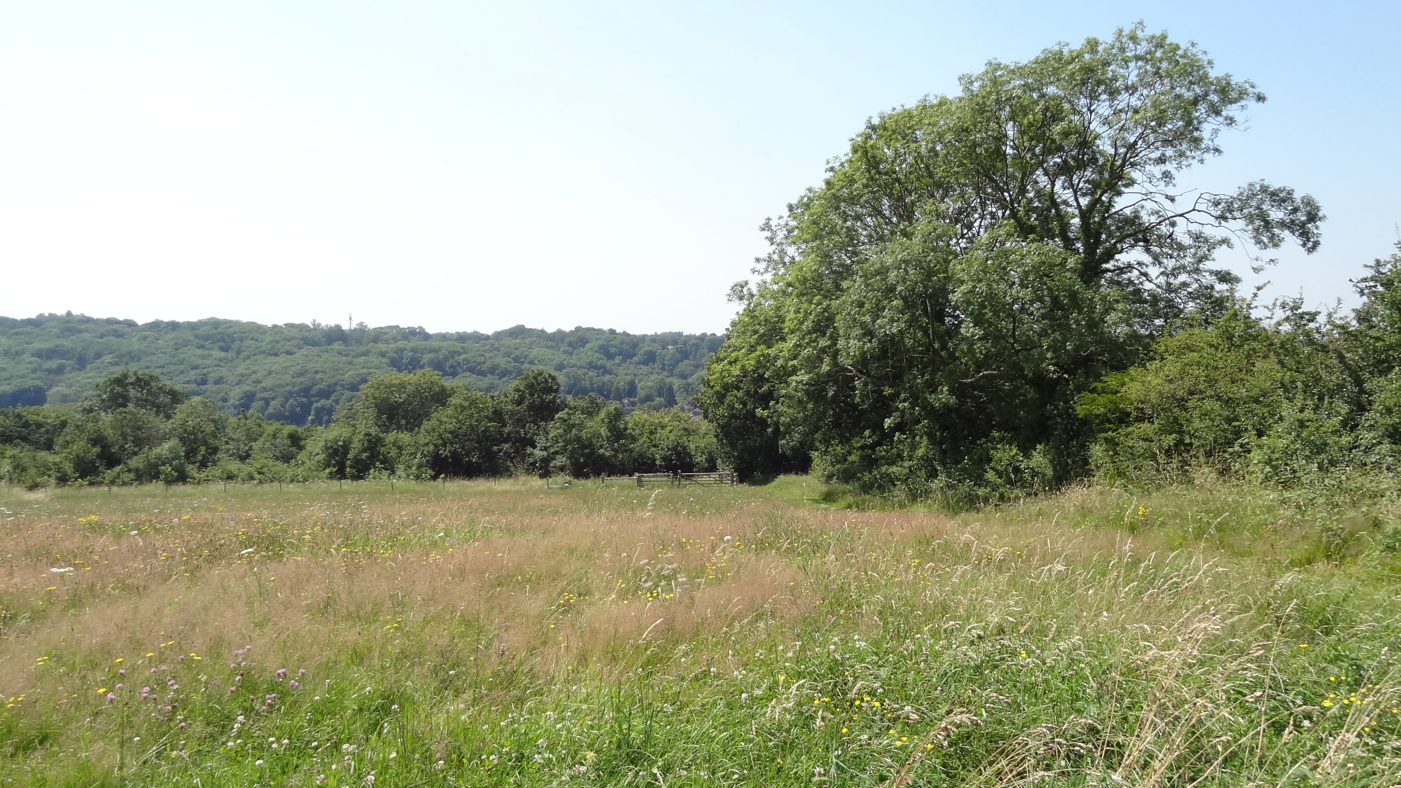
Barnfield Shaw is a picturesque woodland located in Surrey, England. Situated in the heart of the county, it is known for its beautiful and diverse range of trees and wildlife. This enchanting forest covers an area of approximately 100 acres and is a popular destination for nature enthusiasts and hikers.

The woodland is home to a variety of tree species, including oak, beech, birch, and pine. The tall, majestic trees provide a dense canopy that creates a peaceful and serene atmosphere. The forest floor is covered in a thick layer of leaves and moss, giving it a soft and inviting feel.

Barnfield Shaw is also teeming with wildlife. Visitors may catch glimpses of deer, foxes, squirrels, and a wide array of bird species, making it a haven for birdwatchers. The forest is renowned for its rich biodiversity and is protected as a designated nature reserve.

The woodland offers several walking trails, varying in length and difficulty, allowing visitors to explore its hidden treasures at their own pace. The paths wind through the forest, revealing stunning views of ancient trees, babbling brooks, and small ponds.

With its idyllic setting and natural beauty, Barnfield Shaw is a perfect escape from the hustle and bustle of everyday life. Whether it's a peaceful stroll, birdwatching, or simply basking in the tranquility of nature, this woodland provides a peaceful and rejuvenating experience for all who venture within its boundaries.

If you have any feedback on the listing, please let us know in the comments section below.

Barnfield Shaw Images

Images are sourced within 2km of 51.325352/-0.076745313 or Grid Reference TQ3460. Thanks to Geograph Open Source API. All images are credited.

Hamsey Green The parade of shops at Hamsey Green
Hamsey Green
The parade of shops at Hamsey Green
Whyteleafe station Whyteleafe station, situated near a level crossing.  The buildings next to the station are some local office buildings and the centre of the town is just around the corner.
Whyteleafe station
Whyteleafe station, situated near a level crossing. The buildings next to the station are some local office buildings and the centre of the town is just around the corner.
Down train to Caterham The Class 455 train, still in Connex South Central livery, is photographed looking north-west from the overbridge carrying the London Loop walk
Down train to Caterham
The Class 455 train, still in Connex South Central livery, is photographed looking north-west from the overbridge carrying the London Loop walk
All Saints Church (C of E), Kenley, Surrey
New housing development at Kingswood Lane, Hamsey Green, Surrey More little boxes...
New housing development at Kingswood Lane, Hamsey Green, Surrey
More little boxes...
Miniature railway at Upper Warlingham 27 September 1987 was the first day of electric operation to East Grinstead on the (then) Southern Region of British Railways.  To celebrate this auspicious occasion, various events were arranged at stations along the line, including the provision of this small railway at Upper Warlingham.  Perhaps it was not well publicised, but it seemed that few children turned up to see it.
Miniature railway at Upper Warlingham
27 September 1987 was the first day of electric operation to East Grinstead on the (then) Southern Region of British Railways. To celebrate this auspicious occasion, various events were arranged at stations along the line, including the provision of this small railway at Upper Warlingham. Perhaps it was not well publicised, but it seemed that few children turned up to see it.
Upper Warlingham station On the first day of electric services on the East Grinstead line, a '4-CIG' unit is seen on a Down working.
Upper Warlingham station
On the first day of electric services on the East Grinstead line, a '4-CIG' unit is seen on a Down working.
Coming in to land! An ATC Viking glider above Kenley Airfield, coming in to land after a short training flight.  (See <a href="https://www.geograph.org.uk/photo/711718">TQ3358 : Gliders at Kenley Airfield</a> for more info)
Coming in to land!
An ATC Viking glider above Kenley Airfield, coming in to land after a short training flight. (See TQ3358 : Gliders at Kenley Airfield for more info)
Down steam train on Riddlesdown Viaduct Shows the now-defunct lime works.
Down steam train on Riddlesdown Viaduct
Shows the now-defunct lime works.
The Goodies, Hamsey Green The Good Companions inn. Corner of Limpsfield Road and Tithepit Shaw Lane, Warlingham.
The Goodies, Hamsey Green
The Good Companions inn. Corner of Limpsfield Road and Tithepit Shaw Lane, Warlingham.
Whyteleafe Tavern Godstone Road, Whyteleafe.
Whyteleafe Tavern
Godstone Road, Whyteleafe.
New Barn Lane Bus Shelter at Whyteleafe
Gasometer at Whyteleafe
Motos Car Spare Emporium at Kenley One of those old shops that seems to have evolved and prospered over some decades.
Motos Car Spare Emporium at Kenley
One of those old shops that seems to have evolved and prospered over some decades.
St Antony's church, Hamsey Green The church, which doubles as a community centre, was built in 1957.  It is a daughter church of All Saints, Sanderstead <a href="https://www.geograph.org.uk/photo/19905">TQ3461 : Sanderstead Church</a>.
St Antony's church, Hamsey Green
The church, which doubles as a community centre, was built in 1957. It is a daughter church of All Saints, Sanderstead TQ3461 : Sanderstead Church.
Wentworth Way, Hamsey Green Looking south from the junction with Clyde Avenue.  The housing is typical of this area.
Wentworth Way, Hamsey Green
Looking south from the junction with Clyde Avenue. The housing is typical of this area.
All Saints Church (C of E), Kenley, Surrey All Saints Church (C of E), Kenley, Surrey in the snow.
All Saints Church (C of E), Kenley, Surrey
All Saints Church (C of E), Kenley, Surrey in the snow.
Hawkhirst Road Kenley Hawkhirst Road Kenley heading through the woods as a bridleway.
Hawkhirst Road Kenley
Hawkhirst Road Kenley heading through the woods as a bridleway.
Show me another place!

Barnfield Shaw is located at Grid Ref: TQ3460 (Lat: 51.325352, Lng: -0.076745313)

Unitary Authority: Croydon

Police Authority: Metropolitan

What 3 Words

///pull.paid.glow. Near Whyteleafe, Surrey

Related Wikis

Riddlesdown Collegiate

Riddlesdown Collegiate (formerly Riddlesdown High School) is a secondary school with academy status located in the Riddlesdown area of the London Borough...

London Borough of Croydon

The London Borough of Croydon () is a London borough in south London, part of Outer London. It covers an area of 87 km2 (33.6 sq mi). It is the southernmost...

Warlingham School

Warlingham School is a large secondary school with pupils aged 11–16, and also has a sixth form for 16- to 18-year-olds. The school is located in the village...

Riddlesdown Common

Riddlesdown Common or Riddlesdown is a 43 hectare area of green space in Kenley, towards the northern end of the North Downs in the London Borough of Croydon...

Nearby Amenities

Located within 500m of 51.325352,-0.076745313
Crossing
Button Operated: yes
Crossing: traffic_signals
Crossing Ref: pelican
Lat/Long: 51.3286084/-0.0734526
Traffic Calming: cushion
Lat/Long: 51.3230384/-0.071524
Traffic Calming: cushion
Lat/Long: 51.32362/-0.0716057
Traffic Calming: cushion
Lat/Long: 51.324315/-0.0714787
Traffic Calming: cushion
Lat/Long: 51.3250267/-0.0711465
Traffic Calming: table
Lat/Long: 51.3254907/-0.0701509
Created By: Potlatch 0.5a
Lat/Long: 51.3245203/-0.0780498
Created By: Potlatch 0.5a
Lat/Long: 51.3246813/-0.0771255
Created By: Potlatch 0.5a
Lat/Long: 51.3260125/-0.0775999
Created By: Potlatch 0.5a
Lat/Long: 51.3262067/-0.0768386
Created By: Potlatch 0.5a
Lat/Long: 51.3244716/-0.0758746
Created By: Potlatch 0.5a
Lat/Long: 51.3225282/-0.0752665
Created By: Potlatch 0.5a
Lat/Long: 51.3222881/-0.0757279
Created By: Potlatch 0.5a
Lat/Long: 51.322194/-0.0760905
Created By: Potlatch 0.5a
Lat/Long: 51.3222383/-0.0770508
Created By: Potlatch 0.5a
Lat/Long: 51.3223072/-0.0776029
Created By: Potlatch 0.5a
Lat/Long: 51.3235715/-0.0787371
Created By: Potlatch 0.5a
Lat/Long: 51.3247068/-0.0787326
Created By: Potlatch 0.5a
Lat/Long: 51.3253214/-0.0791706
Created By: Potlatch 0.5a
Lat/Long: 51.3259863/-0.0797899
Created By: Potlatch 0.5a
Lat/Long: 51.326722/-0.0803361
Barrier: entrance
Lat/Long: 51.3246731/-0.0788326
Bus Stop
Hillsmead Way
Naptan AtcoCode: 490008244S
Naptan Bearing: N
Naptan CommonName: Hillsmead Way
Naptan Street: LIMPSFIELD ROAD
Naptan Verified: no
Network: London Buses
Operator: Transport for London
Public Transport: platform
Ref: 49641
Lat/Long: 51.3270711/-0.0705631
Bus Stop
Sanderstead Methodist Church
Bench: yes
Bin: yes
Naptan AtcoCode: 490011897N
Naptan Bearing: N
Naptan CommonName: Sanderstead Methodist Church
Naptan Street: LIMPSFIELD ROAD
Naptan Verified: no
Network: London Buses
Operator: Transport for London
Public Transport: platform
Ref: 48619
Shelter: yes
Lat/Long: 51.328774/-0.0736978
Bus Stop
Sanderstead Methodist Church
Naptan AtcoCode: 490011897S
Naptan Bearing: N
Naptan CommonName: Sanderstead Methodist Church
Naptan Street: LIMPSFIELD ROAD
Naptan Verified: no
Network: London Buses
Operator: Transport for London
Public Transport: platform
Ref: 74826
Lat/Long: 51.3291804/-0.0738121
Bus Stop
Wentworth Way
Naptan AtcoCode: 490014394N
Naptan Bearing: N
Naptan CommonName: Wentworth Way
Naptan Verified: no
Network: London Buses
Operator: Transport for London
Public Transport: platform
Ref: 58233
Lat/Long: 51.3262625/-0.0697266
Turning Circle
Lat/Long: 51.3277221/-0.0782403
Barrier: entrance
Lat/Long: 51.3221395/-0.076342
Barrier: entrance
Lat/Long: 51.3223421/-0.07867
Barrier: entrance
Lat/Long: 51.3228159/-0.0746457
Barrier: entrance
Lat/Long: 51.3234583/-0.0723107
Barrier: kissing_gate
Lat/Long: 51.325169/-0.0723695
Post Box
Collection Times: Mo-Fr 16:45; Sa 11:45
Drive Through: no
Operator: Royal Mail
Operator Wikidata: Q638098
Post Box Type: pillar
Ref: CR2 375
Royal Cypher: GR
Royal Cypher Wikidata: Q33102273
Source: survey
Lat/Long: 51.3283506/-0.0730158
Kindergarten
Play Place Little Angels Pre School
Addr City: South Croydon
Addr Housename: Sanderstead Methodist Church
Addr Postcode: CR2 9EF
Addr Street: Limpsfield Road
Fhrs Authority: Croydon
Fhrs Id: 190032
Not Addr Postcode: CR2 9DA
Source Addr Postcode: http://www.sandersteadmethodist.org.uk/smchome/postcode/
Source Not Addr Postcode: fhrs
Lat/Long: 51.3285787/-0.0741658
Ref GB Tflcid: RWG216771
Traffic Calming: cushion
Lat/Long: 51.3250727/-0.0699198
The data included in this document is from www.openstreetmap.org. The data is made available under ODbL.

Have you been to Barnfield Shaw?

Leave your review of Barnfield Shaw below (or comments, questions and feedback).