Little Beechhill Wood

Wood, Forest in Middlesex

England

Little Beechhill Wood

Clockwise M25, Enfield Officially named the London Orbital and frequently derided as nothing more than a very big car park, the M25 is a 117-mile orbital motorway that encircles London; one of the world's biggest ring roads (Europe's second longest orbital road after the Berliner Ring, which is 122 miles). It is not, however, a continuous loop of motorway as the Dartford Crossing section (comprising the Dartford Tunnels and the Queen Elizabeth II Bridge) over the Thames and its approach roads are designated as the A282. 

Constructed between 1975 and 1986, the M25 is reputedly the most expensive motorway Britain ever built, costing a total of £909m or roughly £7.5m per mile, but at the time of its planning, the demand for the road was considerably underestimated so that when it was finally completed in 1986, it was already out of date. Demand outstripped capacity within a few years and ever since then it's been very heavily congested. 

The M25 is one of the UK’s busiest motorways, carrying up to 200,000 vehicles and 10,000 HGVs per day (AADT - Annual Average Daily Traffic flow) on the section near to Heathrow Airport. Since its opening in the 1980s, the southern, western and eastern sections have been widened to largely dual four lane (D4M) standard, but much of the motorway retains its dual three lane road (D3M) cross-section as originally built. 

The M25 was home to England's first Variable Speed Limits on motorways between the A3 and M4 in the early 1990s.

<span class="nowrap"><a title="http://www.cbrd.co.uk/motorway/m25/" rel="nofollow ugc noopener" href="http://www.cbrd.co.uk/motorway/m25/">Link</a><img style="margin-left:2px;" alt="External link" title="External link - shift click to open in new window" src="https://s1.geograph.org.uk/img/external.png" width="10" height="10"/></span>  cbrd
<span class="nowrap"><a title="http://www.sabre-roads.org.uk/wiki/index.php?title=M25" rel="nofollow ugc noopener" href="http://www.sabre-roads.org.uk/wiki/index.php?title=M25">Link</a><img style="margin-left:2px;" alt="External link" title="External link - shift click to open in new window" src="https://s1.geograph.org.uk/img/external.png" width="10" height="10"/></span>  SABRE
Clockwise M25, Enfield Credit: David Dixon

Little Beechhill Wood is a small woodland located in Middlesex, England. Covering an area of approximately 10 acres, the wood is a beautiful and tranquil place, offering visitors a peaceful escape from the hustle and bustle of everyday life.

The wood is predominantly made up of beech trees, which provide a stunning canopy of green foliage during the spring and summer months. In autumn, the leaves turn into a vibrant mix of red, orange, and gold, creating a picturesque scene that attracts photographers and nature enthusiasts alike.

Walking through the wood, visitors will find a network of well-maintained footpaths, allowing them to explore the area at their own pace. The paths wind through the trees and lead to secluded clearings, where one can sit and enjoy the sounds of birdsong and the rustling of leaves.

Wildlife is abundant in Little Beechhill Wood, with various species of birds, squirrels, and rabbits calling it home. It is also home to a diverse range of plant life, including bluebells, primroses, and ferns, making it an ideal spot for nature lovers and botanists.

The wood is a popular destination for families and outdoor enthusiasts, offering opportunities for picnicking, nature walks, and photography. It is also a great place for educational visits, with schools often bringing students to learn about the local ecosystem and biodiversity.

Little Beechhill Wood is a hidden gem in Middlesex, providing a serene and picturesque environment for anyone seeking a connection with nature. Whether it's a leisurely stroll, a family outing, or a chance to learn about the natural world, this woodland offers something for everyone.

If you have any feedback on the listing, please let us know in the comments section below.

Little Beechhill Wood Images

Images are sourced within 2km of 51.676309/-0.13833968 or Grid Reference TQ2899. Thanks to Geograph Open Source API. All images are credited.

Clockwise M25, Enfield Officially named the London Orbital and frequently derided as nothing more than a very big car park, the M25 is a 117-mile orbital motorway that encircles London; one of the world's biggest ring roads (Europe's second longest orbital road after the Berliner Ring, which is 122 miles). It is not, however, a continuous loop of motorway as the Dartford Crossing section (comprising the Dartford Tunnels and the Queen Elizabeth II Bridge) over the Thames and its approach roads are designated as the A282. 

Constructed between 1975 and 1986, the M25 is reputedly the most expensive motorway Britain ever built, costing a total of £909m or roughly £7.5m per mile, but at the time of its planning, the demand for the road was considerably underestimated so that when it was finally completed in 1986, it was already out of date. Demand outstripped capacity within a few years and ever since then it's been very heavily congested. 

The M25 is one of the UK’s busiest motorways, carrying up to 200,000 vehicles and 10,000 HGVs per day (AADT - Annual Average Daily Traffic flow) on the section near to Heathrow Airport. Since its opening in the 1980s, the southern, western and eastern sections have been widened to largely dual four lane (D4M) standard, but much of the motorway retains its dual three lane road (D3M) cross-section as originally built. 

The M25 was home to England's first Variable Speed Limits on motorways between the A3 and M4 in the early 1990s.

<span class="nowrap"><a title="http://www.cbrd.co.uk/motorway/m25/" rel="nofollow ugc noopener" href="http://www.cbrd.co.uk/motorway/m25/">Link</a><img style="margin-left:2px;" alt="External link" title="External link - shift click to open in new window" src="https://s1.geograph.org.uk/img/external.png" width="10" height="10"/></span>  cbrd
<span class="nowrap"><a title="http://www.sabre-roads.org.uk/wiki/index.php?title=M25" rel="nofollow ugc noopener" href="http://www.sabre-roads.org.uk/wiki/index.php?title=M25">Link</a><img style="margin-left:2px;" alt="External link" title="External link - shift click to open in new window" src="https://s1.geograph.org.uk/img/external.png" width="10" height="10"/></span>  SABRE
Clockwise M25, Enfield
Officially named the London Orbital and frequently derided as nothing more than a very big car park, the M25 is a 117-mile orbital motorway that encircles London; one of the world's biggest ring roads (Europe's second longest orbital road after the Berliner Ring, which is 122 miles). It is not, however, a continuous loop of motorway as the Dartford Crossing section (comprising the Dartford Tunnels and the Queen Elizabeth II Bridge) over the Thames and its approach roads are designated as the A282. Constructed between 1975 and 1986, the M25 is reputedly the most expensive motorway Britain ever built, costing a total of £909m or roughly £7.5m per mile, but at the time of its planning, the demand for the road was considerably underestimated so that when it was finally completed in 1986, it was already out of date. Demand outstripped capacity within a few years and ever since then it's been very heavily congested. The M25 is one of the UK’s busiest motorways, carrying up to 200,000 vehicles and 10,000 HGVs per day (AADT - Annual Average Daily Traffic flow) on the section near to Heathrow Airport. Since its opening in the 1980s, the southern, western and eastern sections have been widened to largely dual four lane (D4M) standard, but much of the motorway retains its dual three lane road (D3M) cross-section as originally built. The M25 was home to England's first Variable Speed Limits on motorways between the A3 and M4 in the early 1990s. LinkExternal link cbrd LinkExternal link SABRE
Enfield Greenway This walking and cycling track follows the route of the London Loop from The Ridgeway towards Hadley Wood.  As part of the Greenway project, thousands of saplings have been planted along the way.
Enfield Greenway
This walking and cycling track follows the route of the London Loop from The Ridgeway towards Hadley Wood. As part of the Greenway project, thousands of saplings have been planted along the way.
Trent Park Woods Looking North The landscape looks like anywhere in middle England but is inside the M25 motorway in the London Borough of Enfield. In the gap on the horizon between the trees about a third in from the right is the Ridgeway, the road linking Enfield to Potters Bar. The grass in the field had just been mown and baled away. It was a baking June day and I can almost smell the hot cut grass in the photo.
Trent Park Woods Looking North
The landscape looks like anywhere in middle England but is inside the M25 motorway in the London Borough of Enfield. In the gap on the horizon between the trees about a third in from the right is the Ridgeway, the road linking Enfield to Potters Bar. The grass in the field had just been mown and baled away. It was a baking June day and I can almost smell the hot cut grass in the photo.
M25 crossing Cattlegate Road
Holly Hill Farm, The Ridgeway, Enfield Holly Hill Farm on an open day with the M25 in the background.
Holly Hill Farm, The Ridgeway, Enfield
Holly Hill Farm on an open day with the M25 in the background.
Junction of Woodgate Avenue and Coopers Lane Road Road junction off Coopers Lane Road leading to Woodgate Avenue and Oakwell Drive, Northaw, Potters Bar.
Junction of Woodgate Avenue and Coopers Lane Road
Road junction off Coopers Lane Road leading to Woodgate Avenue and Oakwell Drive, Northaw, Potters Bar.
Woodgate Avenue, off Coopers Lane Road Woodgate Avenue is a private road off Coopers Lane Road
Woodgate Avenue, off Coopers Lane Road
Woodgate Avenue is a private road off Coopers Lane Road
Coopers Lane Road, Hertfordshire
Woodland south of Coopers Lane Road, Hertfordshire
Coopers Lane Road, Hertfordshire
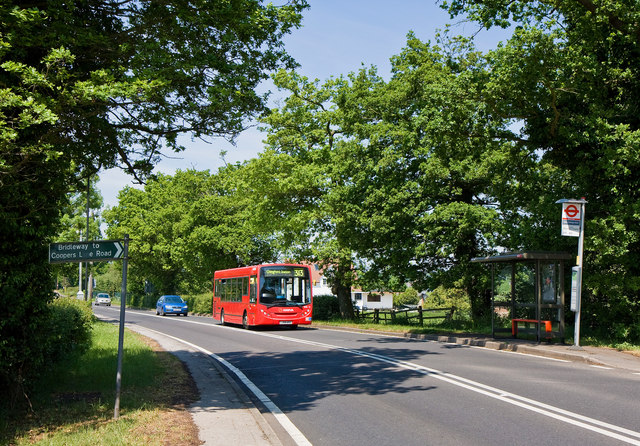
The Ridgeway A 313 bus on route to Chingford passes the stop for New Cottage Farm.  The stop is adjacent to a footpath to Stagg Hill and a bridleway to Coopers Lane Road - the sign indicating the latter being in the foreground on the left.
The Ridgeway
A 313 bus on route to Chingford passes the stop for New Cottage Farm. The stop is adjacent to a footpath to Stagg Hill and a bridleway to Coopers Lane Road - the sign indicating the latter being in the foreground on the left.
Bridleway to Coopers Lane Road Hedges on both sides as it passes New Cottage Farm.  Plenty of Cow Parsley on the left and the elderberry is starting to flower on the right.   In the distance is the M25 motorway.
Bridleway to Coopers Lane Road
Hedges on both sides as it passes New Cottage Farm. Plenty of Cow Parsley on the left and the elderberry is starting to flower on the right. In the distance is the M25 motorway.
Bridleway to Coopers Lane Road Close to New Cottage Farm, the bridleway passes under the busy M25 motorway.  On this day the traffic was flowing freely, but sometimes it can be stationary here as trouble at junction 23 causes tailbacks past junction 24, the Potters Bar turn off.
Bridleway to Coopers Lane Road
Close to New Cottage Farm, the bridleway passes under the busy M25 motorway. On this day the traffic was flowing freely, but sometimes it can be stationary here as trouble at junction 23 causes tailbacks past junction 24, the Potters Bar turn off.
Field Beside the M25 Seen from the bridleway connecting The Ridgeway with Coopers Lane Road.
Field Beside the M25
Seen from the bridleway connecting The Ridgeway with Coopers Lane Road.
Refuse Containers A pair of retired refuse containers and a pile of hardcore beside the bridleway between The Ridgeway and Coopers Lane Road.
Refuse Containers
A pair of retired refuse containers and a pile of hardcore beside the bridleway between The Ridgeway and Coopers Lane Road.
Tunnel under M25 Bridle path back towards A1005 Enfield
Tunnel under M25
Bridle path back towards A1005 Enfield
London Orbital sign east of Potters Bar
Fields south of the M25 near North Lodge Farm
Show me another place!

Little Beechhill Wood is located at Grid Ref: TQ2899 (Lat: 51.676309, Lng: -0.13833968)

Unitary Authority: Enfield

Police Authority: Metropolitan

What 3 Words

///option.ended.backup. Near Hadley Wood, London

Related Wikis

St John's Senior School

St. John's Prep and Senior School is an English all-through school, co-educational day school near the M25 motorway in The Ridgeway, Botany Bay, Enfield...

Botany Bay, London

Botany Bay is a hamlet in Enfield, England, on the outskirts of north London, located within the London Borough of Enfield. It has a population close to...

Trent Park

Trent Park is an English country house, together with its former extensive grounds, in north London. The original great house and a number of statues and...

Beech Hill Park

Beech Hill Park is a Grade II listed building off Beech Hill in Hadley Wood, North London, that is used today as the club house of Hadley Wood Golf Course...

Nearby Amenities

Located within 500m of 51.676309,-0.13833968
Enfield Chase
Bicycle: yes
Hiking: yes
Information: guidepost
Tourism: information
Lat/Long: 51.6737494/-0.1345208
Bench
Backrest: no
Lat/Long: 51.673534/-0.1346228
Bench
Backrest: no
Lat/Long: 51.6735515/-0.1347475
The data included in this document is from www.openstreetmap.org. The data is made available under ODbL.

Have you been to Little Beechhill Wood?

Leave your review of Little Beechhill Wood below (or comments, questions and feedback).