End, North

Settlement in Lancashire

England

End, North

Camp Hill: The Sunken Garden When the City of Liverpool acquired the Woolton Woods and Camp Hill sites in the 1920s, the Dutch Garden of Meditation was created here in 1928. The pool and garden ornaments in that garden have long since disappeared and the area is now known as the Sunken Garden.

Please see Sue Adair's <a href="https://www.geograph.org.uk/photo/338286">SJ4285 : Sunken Garden, Woolton Woods</a> for a view, in the opposite direction, from 2007.
Camp Hill: The Sunken Garden Credit: Nigel Cox

End is a small village located in the North of Lancashire, England. Situated amidst the picturesque countryside, it is nestled in the Lune Valley, near the border with Cumbria. With a population of around 500 residents, End exudes a tranquil and close-knit community atmosphere.

The village is renowned for its natural beauty, boasting stunning landscapes that attract visitors seeking respite from urban life. Surrounded by rolling hills and lush meadows, End offers numerous walking and hiking trails, making it a popular destination for outdoor enthusiasts. The nearby River Lune also provides opportunities for fishing and boating.

Although small, End has a few essential amenities for its residents, including a local pub, a village hall, and a primary school. The pub serves as a social hub, where locals gather to unwind and engage in friendly conversation. The village hall hosts various community events, such as fairs and meetings, fostering a strong sense of community spirit.

Historically, End was primarily an agricultural village, with farming playing a vital role in its economy. While the agricultural industry remains significant, the village has also seen a shift towards tourism, with several bed and breakfast establishments and holiday cottages catering to visitors.

End's central location provides convenient access to nearby towns and cities. The city of Lancaster is approximately 10 miles south, offering a wider range of amenities and cultural attractions. The Lake District National Park is also within driving distance, making it an ideal base for exploring this renowned tourist destination.

Overall, End is a charming and idyllic village that offers a peaceful retreat in the heart of Lancashire's countryside, where residents and visitors alike can appreciate the beauty of nature and experience a strong sense of community.

If you have any feedback on the listing, please let us know in the comments section below.

End, North Images

Images are sourced within 2km of 53.376871/-2.8432424 or Grid Reference SJ4487. Thanks to Geograph Open Source API. All images are credited.

Camp Hill: The Sunken Garden When the City of Liverpool acquired the Woolton Woods and Camp Hill sites in the 1920s, the Dutch Garden of Meditation was created here in 1928. The pool and garden ornaments in that garden have long since disappeared and the area is now known as the Sunken Garden.

Please see Sue Adair's <a href="https://www.geograph.org.uk/photo/338286">SJ4285 : Sunken Garden, Woolton Woods</a> for a view, in the opposite direction, from 2007.
Camp Hill: The Sunken Garden
When the City of Liverpool acquired the Woolton Woods and Camp Hill sites in the 1920s, the Dutch Garden of Meditation was created here in 1928. The pool and garden ornaments in that garden have long since disappeared and the area is now known as the Sunken Garden. Please see Sue Adair's SJ4285 : Sunken Garden, Woolton Woods for a view, in the opposite direction, from 2007.
Hunts Cross railway station, Merseyside Opened in 1874 by the Cheshire Line Committee on the line from Manchester Central to Liverpool Central via Warrington. 
View west towards Liverpool South Parkway and Liverpool. The two lines straddling the island platform were electrified in 1983, but only the bay on the far right of the image is normally used, being the terminus from Liverpool Central. The lifts and their towers were provided in 2022. See <a href="https://www.geograph.org.uk/photo/3447889">SJ4385 : Hunts Cross railway station, Merseyside, 2009</a> for an earlier view from a similar camera position.
Hunts Cross railway station, Merseyside
Opened in 1874 by the Cheshire Line Committee on the line from Manchester Central to Liverpool Central via Warrington. View west towards Liverpool South Parkway and Liverpool. The two lines straddling the island platform were electrified in 1983, but only the bay on the far right of the image is normally used, being the terminus from Liverpool Central. The lifts and their towers were provided in 2022. See SJ4385 : Hunts Cross railway station, Merseyside, 2009 for an earlier view from a similar camera position.
Brown Cow, Halewood Road, Liverpool Lively and heavily-timbered pub - probably a stretch to call it half-timbered. Grade II listed.
It re-opened in 2021 under the ownership of Hawthorn, a community pub company.
Brown Cow, Halewood Road, Liverpool
Lively and heavily-timbered pub - probably a stretch to call it half-timbered. Grade II listed. It re-opened in 2021 under the ownership of Hawthorn, a community pub company.
19 Halewood Road, Liverpool A three-bay house in chequered brick. Early C19th. Grade II listed.
19 Halewood Road, Liverpool
A three-bay house in chequered brick. Early C19th. Grade II listed.
28 Gateacre Brow, Liverpool A spirited affair, half-timbered with a corner turret and pargetting "apparently moulded from Flemish C17 panels illustrating scenes from the Bible". By W. Aubrey Thomas, 1889-91. Grade II listed.
At the time it was advertised for sale. Part of it was occupied by Hair Fairy Wigs.
28 Gateacre Brow, Liverpool
A spirited affair, half-timbered with a corner turret and pargetting "apparently moulded from Flemish C17 panels illustrating scenes from the Bible". By W. Aubrey Thomas, 1889-91. Grade II listed. At the time it was advertised for sale. Part of it was occupied by Hair Fairy Wigs.
4 Gateacre Brow, Liverpool The only unaltered Georgian house in a short run. Built in the distinctive local red sandstone. Grade II listed.
4 Gateacre Brow, Liverpool
The only unaltered Georgian house in a short run. Built in the distinctive local red sandstone. Grade II listed.
Grange Lodge, Grange Lane, Liverpool The conspicuous half-timbered parts date from 1867 and the 1890s, and the brick section beyond is 1820s, but the garden front has parts dating back to the mid C17th. Grade II listed.
Grange Lodge, Grange Lane, Liverpool
The conspicuous half-timbered parts date from 1867 and the 1890s, and the brick section beyond is 1820s, but the garden front has parts dating back to the mid C17th. Grade II listed.
Soarer Cottages, Grange Lane, Liverpool Four attractive houses in brick and stone by R.T. Beckett, 1896, for William Hall Walker. Grade II listed.
Soarer Cottages, Grange Lane, Liverpool
Four attractive houses in brick and stone by R.T. Beckett, 1896, for William Hall Walker. Grade II listed.
Former stables, Grange Lane, Liverpool Extensive former stabling for the clearly numerous polo ponies of William Hall Walker, who lived at Gateacre Grange. By R.T. Beckett, 1895. Grade II listed.
Converted to housing in 1982.
Former stables, Grange Lane, Liverpool
Extensive former stabling for the clearly numerous polo ponies of William Hall Walker, who lived at Gateacre Grange. By R.T. Beckett, 1895. Grade II listed. Converted to housing in 1982.
Gateway, Halewood Road, Liverpool A fine early C18th rusticated example, once leading to a house (Gateacre Hall?) which was demolished in 2004 for new blocks of flats. Grade II listed.
Gateway, Halewood Road, Liverpool
A fine early C18th rusticated example, once leading to a house (Gateacre Hall?) which was demolished in 2004 for new blocks of flats. Grade II listed.
Hunt's Cross Station Hunt's Cross is the southern terminus of Merseyrail's Northern Line and is also served by trains between Liverpool and Manchester via Warrington.
Hunt's Cross Station
Hunt's Cross is the southern terminus of Merseyrail's Northern Line and is also served by trains between Liverpool and Manchester via Warrington.
Hunt's Cross Station Platform 2, looking towards Warrington.
Hunt's Cross Station
Platform 2, looking towards Warrington.
Woolton Hill Road Woolton Hill Road was described in The Enclosure Act of 1805 as Red Brow, "40 ft wide, where hitherto the cows and sheep of Gateacre had drifted to their common pastures".  Woolton Hill would have been common land of rough scrubland and red sandstone outcrops prior to becoming a favoured location for wealthy merchants to build grand country mansions. The house to the right is simply named "The Cottage" on early maps and is linked to the grand house Baycliff built in 1869-71 (now the residence of Liverpool's Anglican bishops known as Bishop's Lodge).
Woolton Hill Road
Woolton Hill Road was described in The Enclosure Act of 1805 as Red Brow, "40 ft wide, where hitherto the cows and sheep of Gateacre had drifted to their common pastures". Woolton Hill would have been common land of rough scrubland and red sandstone outcrops prior to becoming a favoured location for wealthy merchants to build grand country mansions. The house to the right is simply named "The Cottage" on early maps and is linked to the grand house Baycliff built in 1869-71 (now the residence of Liverpool's Anglican bishops known as Bishop's Lodge).
Former site of Gateacre Garden Centre The new housing development on the former site of Gateacre Garden Centre, see original picture. <a title="https://www.geograph.org.uk/photo/338875" href="https://www.geograph.org.uk/photo/338875">Link</a> The garden centre business closed in 2014 after more than 80 years in the same family, although it is thought a nursery existed on this site for around a hundred years.
Former site of Gateacre Garden Centre
The new housing development on the former site of Gateacre Garden Centre, see original picture. Link The garden centre business closed in 2014 after more than 80 years in the same family, although it is thought a nursery existed on this site for around a hundred years.
Hunts Cross railway station A local electric multiple-unit for Southport via Liverpool Central awaits custom on the left, the connecting service from Manchester and Warrington having already departed from the rightmost platform.
Hunts Cross railway station
A local electric multiple-unit for Southport via Liverpool Central awaits custom on the left, the connecting service from Manchester and Warrington having already departed from the rightmost platform.
St Hilda's, Hunts Cross 1898 by architects Bruxby and Evans
St Hilda's, Hunts Cross
1898 by architects Bruxby and Evans
Woolton Manor Care Home Built 1869 and extended 1875 to a design in Gothic Revival style by Thomas Worthington.

The building was used as an Auxiliary Hospital during the Great War.

Now used as a Care Home.
Woolton Manor Care Home
Built 1869 and extended 1875 to a design in Gothic Revival style by Thomas Worthington. The building was used as an Auxiliary Hospital during the Great War. Now used as a Care Home.
Woolton Hall Grade I Listed Building built in 1704 and extensively renovated by Robert Adam in 1772 and considered among his finest work in the northwest of England. 
The building was used as an Auxiliary Hospital during the Great War.
Between the wars the hall was used by the Middlesex Regiment. The Sisters of Notre Dame ran a catholic school in the hall from 1950 moving out to a new building in the 1970s. The building was allowed to fall into disrepair and was saved from demolition by John Hibbert. Faded signs on the gates show the building was used for weddings, banquets and conferences. There were plans in 2016 for conversion to retirement apartments but there were no signs of action in February 2018.
Woolton Hall
Grade I Listed Building built in 1704 and extensively renovated by Robert Adam in 1772 and considered among his finest work in the northwest of England. The building was used as an Auxiliary Hospital during the Great War. Between the wars the hall was used by the Middlesex Regiment. The Sisters of Notre Dame ran a catholic school in the hall from 1950 moving out to a new building in the 1970s. The building was allowed to fall into disrepair and was saved from demolition by John Hibbert. Faded signs on the gates show the building was used for weddings, banquets and conferences. There were plans in 2016 for conversion to retirement apartments but there were no signs of action in February 2018.
Show me another place!

End, North is located at Grid Ref: SJ4487 (Lat: 53.376871, Lng: -2.8432424)

Unitary Authority: Liverpool

Police Authority: Merseyside

What 3 Words

///reform.ritual.gained. Near Huyton, Merseyside

Nearby Locations

End, North Woodlands

Related Wikis

Gateacre

Gateacre ( ; GAT-uh-kuh) is a suburb of Liverpool, England, located approximately 6 miles (9.7 km) south of the city centre. It is bordered by the suburbs...

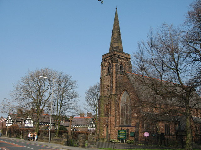
St Stephen's Church, Gateacre

St Stephen's Church is in Belle Vale Road, Gateacre, Liverpool, Merseyside, England. It is an active Anglican parish church in the deanery of Liverpool...

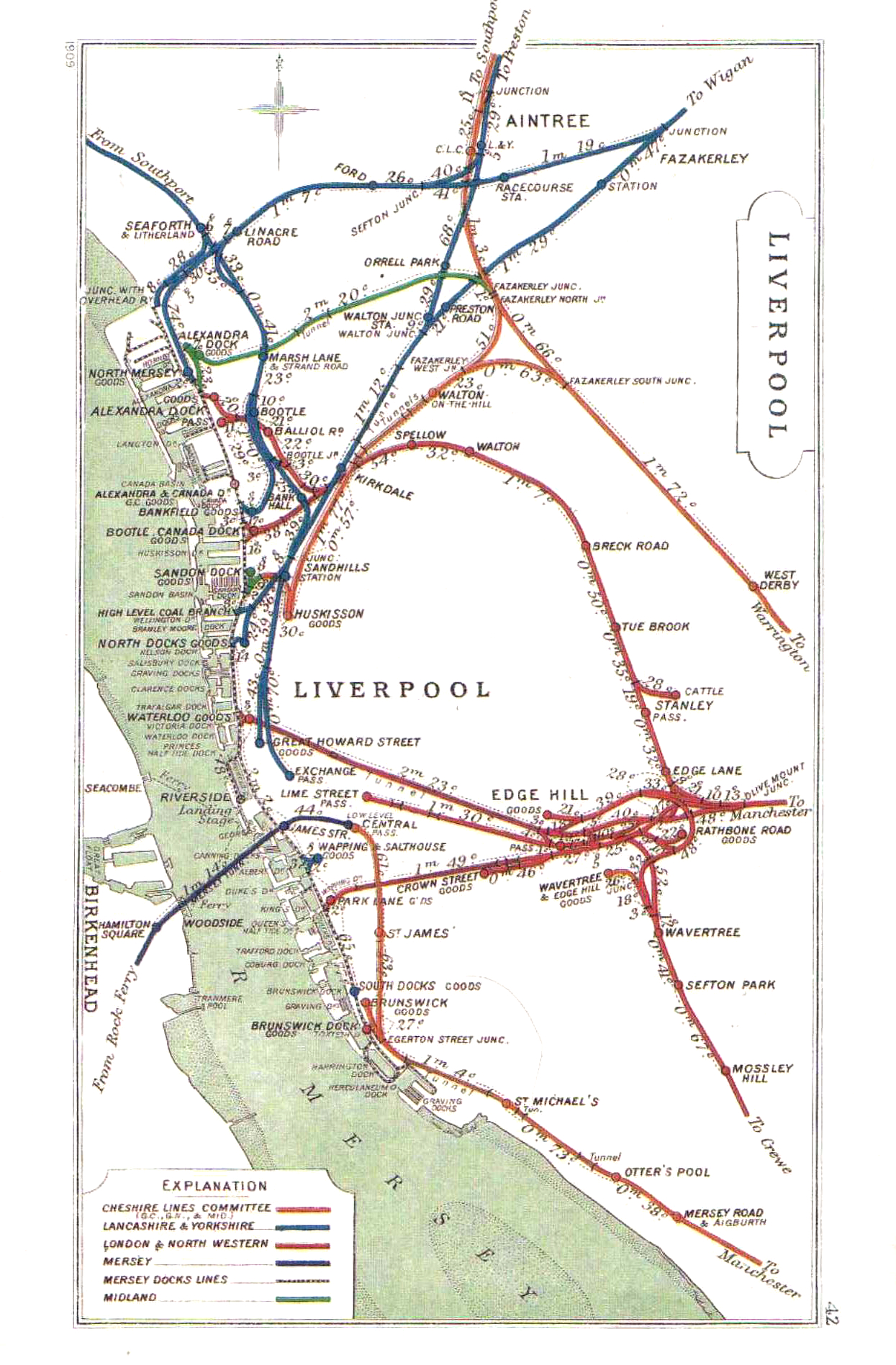
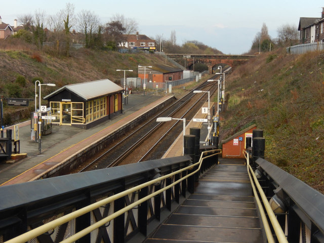
Gateacre railway station

Gateacre (for Woolton) railway station was located on the North Liverpool Extension Line on the north side of Belle Vale Road, Gateacre, Liverpool, England...

Netherley, Liverpool

Netherley is an area in the city of Liverpool, Merseyside, England. It is bordered by Belle Vale and situated near to Huyton, Tarbock and Halewood. Netherley...

Nearby Amenities

Located within 500m of 53.376871,-2.8432424
Bus Stop
Bus: yes
Public Transport: platform
Lat/Long: 53.3741052/-2.8426946
Traffic Calming: chicane
Lat/Long: 53.3750218/-2.8489003
Bus Stop
CHURCH ROAD/GERRARDS LANE
Bus: yes
Naptan AtcoCode: 2800S48043A
Naptan Bearing: SE
Naptan CommonName: CHURCH ROAD/GERRARDS LANE
Naptan Indicator: CHURCH ROAD/OKELL LANE
Naptan Landmark: CH RD/GERRARDS LN
Naptan NaptanCode: merdtmdw
Naptan Notes: No Notes
Naptan PlusbusZoneRef: LVRPLCH
Naptan ShortCommonName: Ch Rd/Gerrards Ln
Naptan Street: CHURCH ROAD
Naptan Verified: no
Public Transport: platform
Source: naptan_import
Lat/Long: 53.3745839/-2.8403291
Bus Stop
OKELL DRIVE/LYDIATE LANE/CHURCH ROAD
Bus: yes
Naptan AtcoCode: 2800S48165A
Naptan Bearing: E
Naptan CommonName: OKELL DRIVE/LYDIATE LANE/CHURCH ROAD
Naptan Indicator: OKELL DRIVE/LYDIATE LANE/CHURCH ROAD
Naptan Landmark: 8 COMFREY GROVE TO REAR
Naptan NaptanCode: merdtpja
Naptan Notes: No Notes
Naptan PlusbusZoneRef: LVRPLCH
Naptan ShortCommonName: Okell Dr/Lydiate Ln
Naptan Street: OKELL DRIVE
Naptan Verified: no
Public Transport: platform
Source: naptan_import
Lat/Long: 53.3742246/-2.8428474
Bus Stop
OKELL DRIVE/LYDIATE LANE/CHURCH ROAD
Bus: yes
Naptan AtcoCode: 2800S48165B
Naptan Bearing: SW
Naptan CommonName: OKELL DRIVE/LYDIATE LANE/CHURCH ROAD
Naptan Indicator: OKELL DRIVE/LYDIATE LANE/CHURCH ROAD
Naptan Landmark: OPP WOODBRIDGE AVENUE
Naptan NaptanCode: merdtpjd
Naptan Notes: No Notes
Naptan PlusbusZoneRef: LVRPLCH
Naptan ShortCommonName: Okell Dr/Lydiate Ln
Naptan Street: OKELL DRIVE
Naptan Verified: no
Public Transport: platform
Source: naptan_import
Lat/Long: 53.3738134/-2.8437862
Bus Stop
LYDIATE LANE/CLOVER AVENUE
Bus: yes
Naptan AtcoCode: 2800S48170A
Naptan Bearing: E
Naptan CommonName: LYDIATE LANE/CLOVER AVENUE
Naptan Indicator: LYDIATE LANE OPP CLOVER AVENUE
Naptan Landmark: LYDIATE LN/CLOVER AV
Naptan NaptanCode: merdtpjp
Naptan Notes: No Notes
Naptan PlusbusZoneRef: LVRPLCH
Naptan ShortCommonName: Clover Av
Naptan Street: LYDIATE LANE
Naptan Verified: no
Public Transport: platform
Source: naptan_import
Lat/Long: 53.3755177/-2.8468413
Bus Stop
LYDIATE LANE/CLOVER AVENUE
Bus: yes
Naptan AtcoCode: 2800S48170B
Naptan Bearing: W
Naptan CommonName: LYDIATE LANE/CLOVER AVENUE
Naptan Indicator: LYDIATE LANE/CLOVER AVENUE
Naptan Landmark: LYDIATE LN/CLOVER AV
Naptan NaptanCode: merdtpjt
Naptan Notes: No Notes
Naptan PlusbusZoneRef: LVRPLCH
Naptan ShortCommonName: Clover Av
Naptan Street: LYDIATE LANE
Naptan Verified: no
Public Transport: platform
Source: naptan_import
Lat/Long: 53.3754846/-2.8464348
Bus Stop
CHURCH ROAD/GERRARDS LANE
Bus: yes
Naptan AtcoCode: 2800S48043B
Naptan Bearing: SE
Naptan CommonName: CHURCH ROAD/GERRARDS LANE
Naptan Indicator: CHURCH ROAD/GERRARDS LANE
Naptan Landmark: OPP OKELL DRIVE
Naptan NaptanCode: merdtmga
Naptan Notes: No Notes
Naptan PlusbusZoneRef: LVRPLCH
Naptan ShortCommonName: Ch Rd/Gerrards Ln
Naptan Street: CHURCH ROAD
Naptan Verified: no
Public Transport: platform
Source: naptan_import
Lat/Long: 53.3749706/-2.8407507
Direction: 170
Generator Method: photovoltaic
Generator Output Electricity: yes
Generator Solar Modules: 18
Generator Source: solar
Generator Type: solar_photovoltaic_panel
Location: roof
Power: generator
Lat/Long: 53.3747076/-2.8494162
Direction: 170
Generator Method: photovoltaic
Generator Output Electricity: yes
Generator Solar Modules: 18
Generator Source: solar
Generator Type: solar_photovoltaic_panel
Location: roof
Power: generator
Lat/Long: 53.3747166/-2.8493391
Direction: 170
Generator Method: photovoltaic
Generator Output Electricity: yes
Generator Solar Modules: 16
Generator Source: solar
Generator Type: solar_photovoltaic_panel
Location: roof
Power: generator
Lat/Long: 53.3727827/-2.8438635
Direction: 170
Generator Method: photovoltaic
Generator Output Electricity: yes
Generator Solar Modules: 14
Generator Source: solar
Generator Type: solar_photovoltaic_panel
Location: roof
Power: generator
Lat/Long: 53.372814/-2.8435729
Traffic Signals
Traffic Signals: signal
Traffic Signals Direction: forward
Lat/Long: 53.3751064/-2.8409335
Cycleway: asl
Direction: forward
Lat/Long: 53.3750701/-2.8408853
Traffic Signals
Traffic Signals: signal
Traffic Signals Direction: backward
Lat/Long: 53.3748271/-2.8405577
Cycleway: asl
Direction: backward
Lat/Long: 53.3748635/-2.8406063
Cycleway: asl
Direction: backward
Lat/Long: 53.3750674/-2.8405709
Traffic Signals
Traffic Signals: signal
Traffic Signals Direction: backward
Lat/Long: 53.3750889/-2.8405178
Ford: yes
Lat/Long: 53.3778593/-2.847063
Barrier: cycle_barrier
Lat/Long: 53.3751832/-2.8488086
Waste Basket
Material: metal
Lat/Long: 53.3751851/-2.8488341
The data included in this document is from www.openstreetmap.org. The data is made available under ODbL.

Have you been to End, North?

Leave your review of End, North below (or comments, questions and feedback).