Asserby
Settlement in Lincolnshire East Lindsey
England
Asserby

Asserby is a small village located in the county of Lincolnshire, in the East Midlands region of England. Situated near the coast, the village is nestled amidst picturesque countryside, offering residents and visitors alike a tranquil and idyllic setting.
With a population of around 200 people, Asserby exudes a strong sense of community and charm. The village primarily consists of traditional stone-built houses, giving it a timeless and rustic feel. The well-maintained streets are lined with beautiful gardens and trees, adding to the scenic beauty of the area.
Asserby benefits from its close proximity to the Lincolnshire Wolds, an Area of Outstanding Natural Beauty. This allows residents to enjoy stunning views and explore the diverse landscape of rolling hills, woodlands, and valleys. The village also offers easy access to the coast, with popular seaside towns such as Skegness and Mablethorpe just a short drive away.
Despite its small size, Asserby boasts a strong community spirit and a range of amenities. The village has a local pub, which serves as a focal point for socializing and gathering. Additionally, there is a village hall that hosts various events and activities throughout the year.
For those seeking a peaceful and close-knit community, Asserby in Lincolnshire provides an ideal setting, surrounded by natural beauty and offering a warm and welcoming atmosphere.
If you have any feedback on the listing, please let us know in the comments section below.
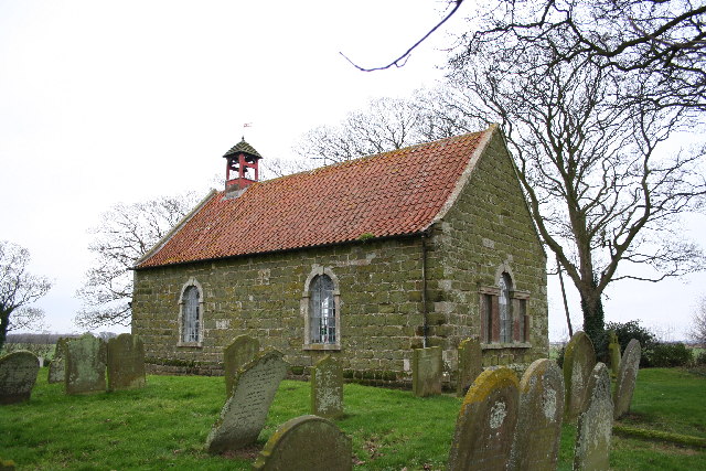
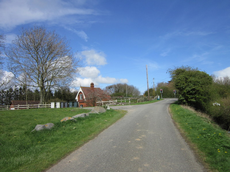
Asserby Images
Images are sourced within 2km of 53.275036/0.239422 or Grid Reference TF4977. Thanks to Geograph Open Source API. All images are credited.


Asserby is located at Grid Ref: TF4977 (Lat: 53.275036, Lng: 0.239422)
Division: Parts of Lindsey
Administrative County: Lincolnshire
District: East Lindsey
Police Authority: Lincolnshire
What 3 Words
///cares.meanders.oblige. Near Alford, Lincolnshire
Nearby Locations
Related Wikis

Markby Priory
Markby Priory was a priory in the village of Markby, Lincolnshire, England. It is believed the Augustinian Priory was founded during the reign of Henry...

Alford and Sutton Tramway
The Alford and Sutton Tramway was a steam 2 ft 6 in (762 mm) narrow gauge street tramway between the seaside town of Sutton-on-Sea and the nearby Great...

Markby
Markby is a village and civil parish in the East Lindsey district of Lincolnshire, England. It is situated approximately 4 miles (6 km) north-east from...
Hannah cum Hagnaby
Hannah cum Hagnaby is a civil parish in the East Lindsey district of Lincolnshire, England. It is situated approximately 4 miles (6 km) north-east from...
Mumby Road railway station
Mumby Road railway station was a station on the Great Northern Railway's Mablethorpe Loop line between Willoughby, Mablethorpe and Louth. It served the...

Huttoft
Huttoft is a village in the East Lindsey district of Lincolnshire, England, about 4 miles (6 km) east of the market town of Alford, on the A52 road between...

Bilsby
Bilsby is a village and civil parish in the East Lindsey district of Lincolnshire, England. It lies on the main A1111 road between Alford and Sutton-on...
Hagnaby Abbey
Hagnaby Abbey was an abbey and former priory in Hagnaby, Lincolnshire, England. It was one of nine Premonstratensian houses within the historical county...
Related Videos

HANNAH CUM HAGNABY: East Lindsey Parish #8 of 188
EAST LINDSEY PARISH #8: HANNAH CUM HAGNABY Welcome for the first time, to the Alford area of East Lindsey. This is ...
Nearby Amenities
Located within 500m of 53.275036,0.239422Have you been to Asserby?
Leave your review of Asserby below (or comments, questions and feedback).