Anne's Wood

Wood, Forest in Sussex Mid Sussex

England

Anne's Wood

House on Staplefield Road This is called "Brook Cottage", according to the large scale map.
House on Staplefield Road Credit: Ian Cunliffe

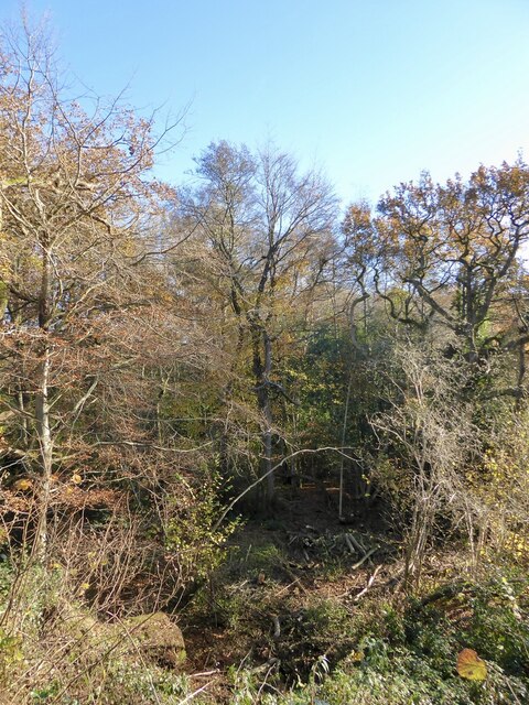
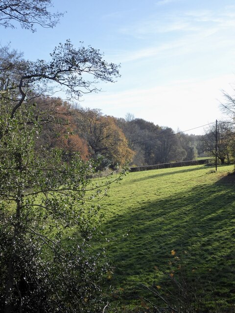
Anne's Wood is a picturesque forest located in Sussex, England. Stretching over an area of approximately 100 acres, it is renowned for its natural beauty and diverse ecosystem. The woodland is part of the larger High Weald Area of Outstanding Natural Beauty and is a popular destination for nature enthusiasts and hikers alike.

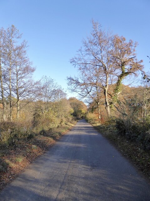
As visitors enter Anne's Wood, they are greeted by a charming entrance with towering oak trees and a well-maintained footpath leading deeper into the forest. The woodland is predominantly made up of broadleaf trees, such as oak, beech, and ash, which provide a dense canopy and create a tranquil atmosphere.

The forest floor is covered with a rich carpet of ferns, bluebells, and wildflowers during the spring season, adding vibrant colors to the surroundings. The wood is home to a wide range of wildlife, including deer, foxes, badgers, and numerous bird species, making it a fantastic spot for wildlife enthusiasts and birdwatchers.

Several well-marked trails crisscross the woodland, offering visitors the opportunity to explore its hidden gems. The paths wind through the forest, leading to picturesque viewpoints, ancient trees, and peaceful clearings, providing ample opportunities for relaxation and contemplation.

Anne's Wood is also steeped in history, with remnants of an old Roman road passing through it. This historical significance adds another layer of intrigue to the woodland, making it a fascinating destination for history buffs as well.

Overall, Anne's Wood in Sussex is a serene and enchanting forest, offering visitors a chance to immerse themselves in nature, discover its rich biodiversity, and enjoy a peaceful retreat away from the bustle of everyday life.

If you have any feedback on the listing, please let us know in the comments section below.

Anne's Wood Images

Images are sourced within 2km of 51.021991/-0.21279574 or Grid Reference TQ2526. Thanks to Geograph Open Source API. All images are credited.

House on Staplefield Road This is called "Brook Cottage", according to the large scale map.
House on Staplefield Road
This is called "Brook Cottage", according to the large scale map.
Equipment at the water treatment plant This is a small site - I couldn't see much else apart from the two green tanks. It smells a bit too, but luckily it's quite a way from any houses
Equipment at the water treatment plant
This is a small site - I couldn't see much else apart from the two green tanks. It smells a bit too, but luckily it's quite a way from any houses
Barn at Rout Farm
Barn at Rout Farm
Slaugham Mill Pond The largest of three ponds along one of the small streams at the head of the River Ouse.
Slaugham Mill Pond
The largest of three ponds along one of the small streams at the head of the River Ouse.
Slaugham Manor Slaugham Manor has had an eventful life. Completed in 1901 as a wealthy family home, it subsequently became a hotel and country club before changing again into a police training centre. It is now apartments.
History on <span class="nowrap"><a title="https://www.linkedin.com/pulse/history-slaugham-manor-superb-conversion-important-house-van-loock/" rel="nofollow ugc noopener" href="https://www.linkedin.com/pulse/history-slaugham-manor-superb-conversion-important-house-van-loock/">Link</a><img style="margin-left:2px;" alt="External link" title="External link - shift click to open in new window" src="https://s1.geograph.org.uk/img/external.png" width="10" height="10"/></span>
Strangely, the 200 metres or so of road past the manor is signed as no public right of way. As the public path walk around is quite lengthy I doubt many people worry about that. 
But if anybody does care, this is a zoom and crop image taken from the public footpath at the end of the private bit.
Slaugham Manor
Slaugham Manor has had an eventful life. Completed in 1901 as a wealthy family home, it subsequently became a hotel and country club before changing again into a police training centre. It is now apartments. History on LinkExternal link Strangely, the 200 metres or so of road past the manor is signed as no public right of way. As the public path walk around is quite lengthy I doubt many people worry about that. But if anybody does care, this is a zoom and crop image taken from the public footpath at the end of the private bit.
Furnace Pond Cottage, Staplefield Road, Slaugham Common A conglomeration of buildings from different eras. The earliest parts dates from the 16th century and was built for an iron worker from nearby Slaugham Furnace. This section is on the right. It was extended in the late 18th century to become a pair of cottages with that part now in the middle. The house became one again in the 1930s when another extension was added on the eastern side.
Furnace Pond Cottage, Staplefield Road, Slaugham Common
A conglomeration of buildings from different eras. The earliest parts dates from the 16th century and was built for an iron worker from nearby Slaugham Furnace. This section is on the right. It was extended in the late 18th century to become a pair of cottages with that part now in the middle. The house became one again in the 1930s when another extension was added on the eastern side.
The Lag The name of the field according to Slaugham's 1842 tithe map that is now woodland. It is bounded to the east by Slaugham Lane and to the north and west by Scotland Gill, a tributary of the River Ouse.
The Lag
The name of the field according to Slaugham's 1842 tithe map that is now woodland. It is bounded to the east by Slaugham Lane and to the north and west by Scotland Gill, a tributary of the River Ouse.
Pond Bay, Slaugham Furnace A view of the southern side of the dam which now carries Hampshire Hill, see <a href="https://www.geograph.org.uk/photo/7659112">TQ2428 : Hampshire Hill</a>, past the pond, see <a href="https://www.geograph.org.uk/photo/7659118">TQ2428 : Furnace Pond</a>. The furnace was known to be in operation between 1574-1601 and was sited at the point Scotland Gill turns south, see <a href="https://www.geograph.org.uk/photo/7659100">TQ2428 : Site of Slaugham Furnace</a>
Pond Bay, Slaugham Furnace
A view of the southern side of the dam which now carries Hampshire Hill, see TQ2428 : Hampshire Hill, past the pond, see TQ2428 : Furnace Pond. The furnace was known to be in operation between 1574-1601 and was sited at the point Scotland Gill turns south, see TQ2428 : Site of Slaugham Furnace
Site of Slaugham Furnace Known to be in operation between 1574 and 1601. The pond bay still survives, see <a href="https://www.geograph.org.uk/photo/7659097">TQ2428 : Pond Bay, Slaugham Furnace</a> and <a href="https://www.geograph.org.uk/photo/7659112">TQ2428 : Hampshire Hill</a>, as well as the pond, see <a href="https://www.geograph.org.uk/photo/7659118">TQ2428 : Furnace Pond</a>.
Site of Slaugham Furnace
Known to be in operation between 1574 and 1601. The pond bay still survives, see TQ2428 : Pond Bay, Slaugham Furnace and TQ2428 : Hampshire Hill, as well as the pond, see TQ2428 : Furnace Pond.
Front Meadow The name of the field according to Slaugham's 1842 tithe map located to the south of the pond bay carrying Hampshire Hill and west of Scotland Gill, a tributary of the River Ouse.
Front Meadow
The name of the field according to Slaugham's 1842 tithe map located to the south of the pond bay carrying Hampshire Hill and west of Scotland Gill, a tributary of the River Ouse.
Hampshire Hill The lane links Ashfold Crossways to Slaugham Common and here traverses across the former pond bay of Slaugham Furnace, see also <a href="https://www.geograph.org.uk/photo/7659097">TQ2428 : Pond Bay, Slaugham Furnace</a>. The site of the furnace was on the southern side, see <a href="https://www.geograph.org.uk/photo/7659100">TQ2428 : Site of Slaugham Furnace</a>, whilst the pond still survives and is to the north, see <a href="https://www.geograph.org.uk/photo/7659118">TQ2428 : Furnace Pond</a>. There are 56 former anti-tank buoys lining the pond side of the road.
Hampshire Hill
The lane links Ashfold Crossways to Slaugham Common and here traverses across the former pond bay of Slaugham Furnace, see also TQ2428 : Pond Bay, Slaugham Furnace. The site of the furnace was on the southern side, see TQ2428 : Site of Slaugham Furnace, whilst the pond still survives and is to the north, see TQ2428 : Furnace Pond. There are 56 former anti-tank buoys lining the pond side of the road.
Barn Meadow The name of the field according to Slaugham's 1842 tithe map located to the south of Hampshire hill and west of Scotland Farm, whose barn can be seen.
Barn Meadow
The name of the field according to Slaugham's 1842 tithe map located to the south of Hampshire hill and west of Scotland Farm, whose barn can be seen.
Three Cornered Field/Three Acres/Little Field The name of the fields according to Slaugham's 1842 tithe map that have been merged along with <a href="https://www.geograph.org.uk/photo/7659122">TQ2428 : Barn Meadow</a> to the east. Little Field is adjacent to Barn Meadow, whilst Three Acres and Three Cornered Field are sandwiched between Hampshire Hill to the north and Hamshire Wood to the south. Three Cornered Field abuts the parish boundary with Lower Beeding whose unnamed field lies in the foreground next to the bridleway heading south to the B2115.
Three Cornered Field/Three Acres/Little Field
The name of the fields according to Slaugham's 1842 tithe map that have been merged along with TQ2428 : Barn Meadow to the east. Little Field is adjacent to Barn Meadow, whilst Three Acres and Three Cornered Field are sandwiched between Hampshire Hill to the north and Hamshire Wood to the south. Three Cornered Field abuts the parish boundary with Lower Beeding whose unnamed field lies in the foreground next to the bridleway heading south to the B2115.
Tulleys Rough A view of the newly planted eastern side of the wood.
Tulleys Rough
A view of the newly planted eastern side of the wood.
Park Field The name of the field according to Slaugham's 1842 tithe map bounded to the east by the village of Slaugham, to the west by Marchants Gill and to the south by Staplefield Road.
Park Field
The name of the field according to Slaugham's 1842 tithe map bounded to the east by the village of Slaugham, to the west by Marchants Gill and to the south by Staplefield Road.
White Cottage, Park Road, Slaugham Dating from around 1720 and catching the late afternoon sun.
White Cottage, Park Road, Slaugham
Dating from around 1720 and catching the late afternoon sun.
Foyles, Park Road, Slaugham Dating back to the 17th century and for a period the village workhouse for men.
Foyles, Park Road, Slaugham
Dating back to the 17th century and for a period the village workhouse for men.
10, The Green, Slaugham Dating back to the 18th century.
10, The Green, Slaugham
Dating back to the 18th century.
Show me another place!

Anne's Wood is located at Grid Ref: TQ2526 (Lat: 51.021991, Lng: -0.21279574)

Administrative County: West Sussex

District: Mid Sussex

Police Authority: Sussex

What 3 Words

///games.towers.diver. Near Handcross, West Sussex

Related Wikis

Warninglid

Warninglid (historically known as Warninglyth and Warningeld) is a small village in the Mid Sussex District of West Sussex, England. It lies on the B2115...

Wykehurst Place

Wykehurst Place (or Park) is a Gothic Revival mansion in Bolney, West Sussex, England, resembling more the châteaux of the Loire than an English manor...

St Mary's Church, Slaugham

St Mary's Church is an Anglican church in the village of Slaugham in Mid Sussex, one of seven local government districts in the English county of West...

Slaugham

Slaugham () is a village and civil parish in the Mid Sussex District of West Sussex, England. It is located 7 miles (11 km) to the south of Crawley, on...

Colwood, West Sussex

Colwood is a village near Warninglid in West Sussex, England. It is the site of Colwood Manor. == References == The geographic coordinates are from the...

Staplefield

Staplefield is a village in the Mid Sussex District of West Sussex, England, situated 6 kilometres (3.7 mi) north-west of Haywards Heath on the B2114...

Ansty and Staplefield

Ansty and Staplefield, previously Cuckfield Rural, is a civil parish in the Mid Sussex District of West Sussex, England, covering an area from the north...

Nymans

Nymans is an English garden to the east of the village of Handcross, and in the civil parish of Slaugham in West Sussex, England. The garden was developed...

Nearby Amenities

Located within 500m of 51.021991,-0.21279574
Warninglid
Place: village
Wikidata: Q7969834
Wikipedia: en:Warninglid
Lat/Long: 51.0205977/-0.21859
Barrier: kissing_gate
Lat/Long: 51.0179142/-0.212686
Bus Stop
Half Moon
Bus: yes
Naptan AtcoCode: 4400HR0513
Naptan Bearing: E
Naptan CommonName: Half Moon
Naptan Indicator: opp pub
Naptan Landmark: Slaugham Lane
Naptan NaptanCode: wsxawmwp
Naptan ShortCommonName: Warninglid HalfMoon
Naptan Street: Cuckfield Lane
Naptan Verified: no
Public Transport: platform
Source: naptan_import
Lat/Long: 51.0208382/-0.2184446
Bus Stop
Half Moon
Bus: yes
Naptan AtcoCode: 4400HR0514
Naptan Bearing: W
Naptan CommonName: Half Moon
Naptan Indicator: o/s pub
Naptan Landmark: Slaugham Lane
Naptan NaptanCode: wsxawmwt
Naptan ShortCommonName: Warninglid HalfMoon
Naptan Street: Cuckfield Lane
Naptan Verified: no
Public Transport: platform
Source: naptan_import
Lat/Long: 51.0207801/-0.2181759
Barrier: stile
Lat/Long: 51.0237286/-0.2068851
Barrier: kissing_gate
Lat/Long: 51.0180992/-0.2139554
Power: pole
Lat/Long: 51.0247846/-0.2178737
Power: pole
Lat/Long: 51.0242647/-0.2180885
Power: pole
Lat/Long: 51.0236332/-0.2183127
Power: pole
Lat/Long: 51.0229455/-0.2185955
Addr City: Haywards Heath
Addr Housename: Council Cottages
Addr Postcode: RH17 5UB
Addr Street: Cuckfield Lane
Addr Village: Warninglid
Lat/Long: 51.0208887/-0.2155504
Addr City: Haywards Heath
Addr Housename: Church Flats
Addr Postcode: RH17 5UB
Addr Street: Cuckfield Lane
Addr Village: Warninglid
Lat/Long: 51.0205504/-0.2181105
Addr City: Haywards Heath
Addr Housename: Colwood Cottages
Addr Postcode: RH17 5SP
Addr Street: Cuckfield Lane
Addr Village: Warninglid
Lat/Long: 51.0207664/-0.2149241
Addr City: Haywards Heath
Addr Housename: Portways Farm Cottages
Addr Postcode: RH17 5SN
Addr Street: Cuckfield Lane
Addr Village: Warninglid
Lat/Long: 51.0205682/-0.2073133
Barrier: stile
Lat/Long: 51.0186315/-0.21458
Leisure: picnic_table
Lat/Long: 51.0194966/-0.2185901
Power: pole
Lat/Long: 51.0192581/-0.2184082
The data included in this document is from www.openstreetmap.org. The data is made available under ODbL.

Have you been to Anne's Wood?

Leave your review of Anne's Wood below (or comments, questions and feedback).