Brokers Garden Wood

Wood, Forest in Hertfordshire Welwyn Hatfield

England

Brokers Garden Wood
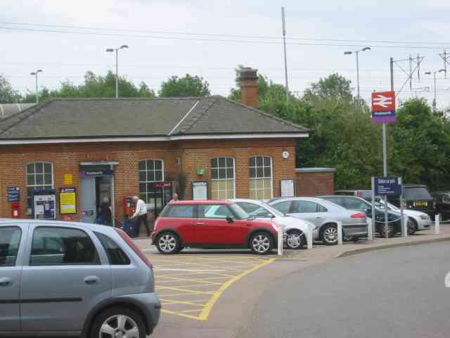
Knebworth Station Just to confirm that one exists
Knebworth Station Credit: Jack Hill

Brokers Garden Wood is a picturesque woodland located in Hertfordshire, England. Covering an area of approximately 50 hectares, this forested area is renowned for its natural beauty and tranquil atmosphere. The wood is situated near the village of Brokers Garden, which adds to its charm and accessibility.

The woodland is predominantly made up of native tree species, including oak, beech, and birch. These trees create a dense canopy, providing shade and shelter for a diverse range of wildlife. Visitors can observe an abundance of bird species, such as woodpeckers, owls, and thrushes, as well as various mammals like deer, foxes, and squirrels.

Brokers Garden Wood offers a network of well-maintained footpaths and trails, allowing visitors to explore its enchanting surroundings. The paths wind through the forest, offering glimpses of the vibrant flora and fauna that thrive within the wood. The forest floor is carpeted with bluebells in the spring, creating a stunning display of color and fragrance.

The woodland is a popular destination for nature enthusiasts, hikers, and families looking to escape the hustle and bustle of everyday life. It offers a peaceful retreat where visitors can connect with nature and enjoy the tranquility of the surroundings. There are also designated picnic areas and benches scattered throughout the wood, providing opportunities for relaxation and contemplation.

Brokers Garden Wood is managed by the local authorities, ensuring its preservation and protection for future generations. It serves as a valuable natural habitat and recreational space, contributing to the overall beauty and biodiversity of Hertfordshire.

If you have any feedback on the listing, please let us know in the comments section below.

Brokers Garden Wood Images

Images are sourced within 2km of 51.851151/-0.18770203 or Grid Reference TL2418. Thanks to Geograph Open Source API. All images are credited.

Knebworth Station Just to confirm that one exists
Knebworth Station
Just to confirm that one exists
Knebworth   Reformed Church The banner at least will perpetuate a sentiment
Knebworth Reformed Church
The banner at least will perpetuate a sentiment
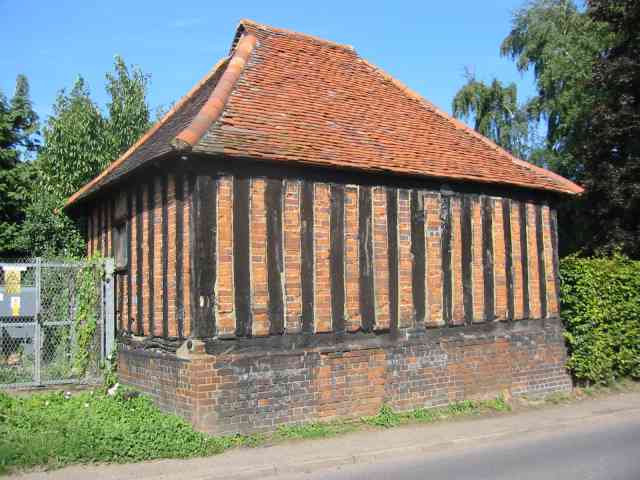
Garden Shed perhaps at Deard's End Lane, Knebworth The incredibly close nature of the timber uprights is very unusual.
Garden Shed perhaps at Deard's End Lane, Knebworth
The incredibly close nature of the timber uprights is very unusual.
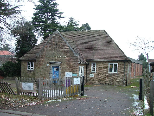
Knebworth telephone exchange With a modern extension on the back.
Knebworth telephone exchange
With a modern extension on the back.
St Martin, Knebworth, Herts
St Martin, Knebworth, Herts - Chapel
St Martin, Knebworth, Herts - East end
St Martin, Knebworth, Herts
St Martin, Knebworth, Herts - Font
St Martin, Knebworth, Herts
St Martin, Knebworth, Herts - East end
Park Lane & Knebworth A view across Park Lane and Knebworth taken after the snowfall at the end of October 2008
Park Lane & Knebworth
A view across Park Lane and Knebworth taken after the snowfall at the end of October 2008
Railway bridges over Station Road This is viewed from Gun Lane.
Railway bridges over Station Road
This is viewed from Gun Lane.
Knebworth Primary & Nursery School Take away the flat-roofed extensions at the front and the remaining three gable-ended buildings represent the basic fabric of the school as it was opened in 1912. The central section has an attractive bell tower. The school was built primarily to serve the large increase in population in "new" Knebworth following the opening of the railway station built to serve "old" Knebworth in 1884.

The photo was taken at the end of a wet November Sunday afternoon that was just about to get an awful lot wetter... 

The School's website is here <span class="nowrap"><a title="http://www.knebworth.herts.sch.uk/" rel="nofollow ugc noopener" href="http://www.knebworth.herts.sch.uk/">Link</a><img style="margin-left:2px;" alt="External link" title="External link - shift click to open in new window" src="https://s1.geograph.org.uk/img/external.png" width="10" height="10"/></span>
Knebworth Primary & Nursery School
Take away the flat-roofed extensions at the front and the remaining three gable-ended buildings represent the basic fabric of the school as it was opened in 1912. The central section has an attractive bell tower. The school was built primarily to serve the large increase in population in "new" Knebworth following the opening of the railway station built to serve "old" Knebworth in 1884. The photo was taken at the end of a wet November Sunday afternoon that was just about to get an awful lot wetter... The School's website is here LinkExternal link
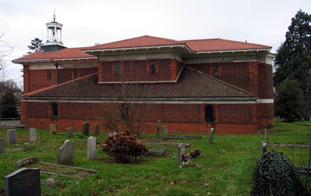
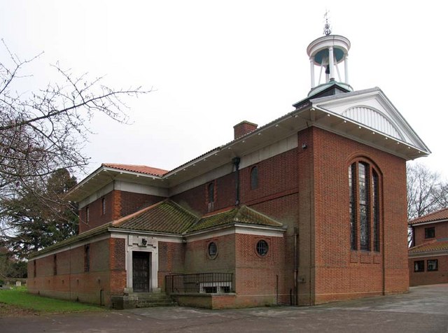
Knebworth: St Martin's Church St Martin's was one of the very few religious buildings designed by the eminent architect, Sir Edwin Landseer Lutyens (1869-1944). Construction commenced in 1914 and the church was consecrated in the following year. Lutyens insisted that only the best materials were to be used and this is reflected in the quality of the brickwork and the pantiled roof. The church hall just visible to the right is a modern development built in the style of the church. Lutyens' connections with Knebworth came from his marriage to a daughter of the local Lytton family in 1897.
Knebworth: St Martin's Church
St Martin's was one of the very few religious buildings designed by the eminent architect, Sir Edwin Landseer Lutyens (1869-1944). Construction commenced in 1914 and the church was consecrated in the following year. Lutyens insisted that only the best materials were to be used and this is reflected in the quality of the brickwork and the pantiled roof. The church hall just visible to the right is a modern development built in the style of the church. Lutyens' connections with Knebworth came from his marriage to a daughter of the local Lytton family in 1897.
Knebworth railway station, Hertfordshire Opened in 1884 by the Great Northern Railway on its line from London to Stevenage. View north towards Stevenage and Peterborough, two years after the station had received new platform shelters and railings. See <a href="https://www.geograph.org.uk/photo/3242098">TL2420 : Knebworth railway station, Hertfordshire, 2008</a> for an earlier view from a similar camera position.
Knebworth railway station, Hertfordshire
Opened in 1884 by the Great Northern Railway on its line from London to Stevenage. View north towards Stevenage and Peterborough, two years after the station had received new platform shelters and railings. See TL2420 : Knebworth railway station, Hertfordshire, 2008 for an earlier view from a similar camera position.
Show me another place!

Brokers Garden Wood is located at Grid Ref: TL2418 (Lat: 51.851151, Lng: -0.18770203)

Administrative County: Hertfordshire

District: Welwyn Hatfield

Police Authority: Hertfordshire

What 3 Words

///hatch.scores.laws. Near Datchworth, Hertfordshire

Related Wikis

Mardley Heath

Mardley Heath is a 41.1 hectare Local Nature Reserve in Welwyn in Hertfordshire. It is owned by Welwyn Hatfield Borough Council and managed by the council...

Woolmer Green

Woolmer Green is a small village and civil parish in Hertfordshire, England. The 2011 census figure for the population (from the Office for National Statistics...

Oaklands, Hertfordshire

Oaklands is a hamlet in the civil parish of Welwyn, in Hertfordshire, England. It is in the Haldens Ward of the Borough of Welwyn Hatfield. In 2020 it...

Broadway Malyan

Broadway Malyan is a global architecture, urbanism and design practice. It was established in 1958 by architects Cyril Broadway and John Malyan. Among...

St Martin's Church, Knebworth

St Martin's Church is an active Anglican church in Knebworth, Hertfordshire, England. The building, which is designated grade II*, was designed by Edwin...

Knebworth

Knebworth is a village and civil parish in the north of Hertfordshire, England, immediately south of Stevenage. The civil parish covers an area between...

Welwyn Tunnel rail crash

The Welwyn Tunnel rail crash took place in Welwyn North Tunnel, north of Welwyn (now Welwyn North) station on the Great Northern Railway, on 9 June 1866...

Homewood, Knebworth

Homewood is an Arts and Crafts style country house in Knebworth, Hertfordshire, England. Designed and built by architect Edwin Lutyens around 1900–3, using...

Nearby Amenities

Located within 500m of 51.851151,-0.18770203
Woolmer Green
Place: village
Website: http://www.woolmergreenpc.org.uk/
Wikidata: Q2051192
Wikipedia: en:Woolmer Green
Lat/Long: 51.8524598/-0.18099
Barrier: horse_stile
Bicycle: yes
Foot: yes
Horse: yes
Lat/Long: 51.8501404/-0.1888222
Railway: switch
Lat/Long: 51.8501244/-0.1836275
Bus Stop
Red Lion PH
Bench: no
Bin: yes
Lit: yes
Naptan AtcoCode: 210021600060
Naptan Bearing: SE
Naptan CommonName: Red Lion PH
Naptan Crossing: Evergreen Close
Naptan Indicator: opp
Naptan Landmark: Evergreen Close
Naptan NaptanCode: hrtatdtd
Naptan ShortCommonName: NA
Naptan Street: London Road
Naptan Verified: no
Shelter: no
Source: naptan_import
Tactile Paving: no
Lat/Long: 51.8524463/-0.1808937
Bus Stop
The Drive
Bench: no
Bin: no
Lit: yes
Naptan AtcoCode: 210021600080
Naptan Bearing: SW
Naptan CommonName: The Drive
Naptan Indicator: opp
Naptan Landmark: Unknown
Naptan NaptanCode: hrtatdtj
Naptan PlusbusZoneRef: WLWYNGC
Naptan ShortCommonName: NA
Naptan Street: Mardley Hill
Naptan Verified: no
Shelter: no
Source: naptan_import
Tactile Paving: no
Lat/Long: 51.8475781/-0.1853296
Bus Stop
The Drive
Bench: no
Bin: no
Lit: yes
Local Ref: NR
Naptan AtcoCode: 210021607600
Naptan Bearing: SW
Naptan CommonName: The Drive
Naptan Indicator: nr
Naptan Landmark: Unknown
Naptan NaptanCode: hrtamjwp
Naptan PlusbusZoneRef: WLWYNGC
Naptan ShortCommonName: NA
Naptan Street: Mardley Hill
Naptan Verified: no
Shelter: no
Source: naptan_import
Tactile Paving: no
Lat/Long: 51.8479306/-0.1848653
Bus Stop
Red Lion PH
Bench: yes
Bin: yes
Lit: yes
Local Ref: NR
Naptan AtcoCode: 210021607620
Naptan Bearing: NW
Naptan CommonName: Red Lion PH
Naptan Crossing: Bridge Road
Naptan Indicator: nr
Naptan Landmark: Bridge Road
Naptan NaptanCode: hrtampad
Naptan PlusbusZoneRef: WLWYNGC
Naptan ShortCommonName: NA
Naptan Street: London Road
Naptan Verified: no
Shelter: yes
Source: naptan_import
Tactile Paving: yes
Lat/Long: 51.8528217/-0.1813287
Speed Camera
Lat/Long: 51.8471129/-0.1863414
Post Box
Addr City: Woolmer Green
Addr Street: Longmead
Collection Times: Mo-Fr 16:00; Sa 10:00
Operator: Royal Mail
Post Box Type: lamp
Ref: SG3 37
Royal Cypher: EIIR
Royal Cypher Wikidata: Q33102113
Source: stop-motion GPS
Lat/Long: 51.854206/-0.183077
Post Box
Addr City: Woolmer Green
Addr Street: London Road
Collection Times: Mo-Fr 17:00; Sa 09:30
Note: No Post Office here, despite RM saying there is!
Operator: Royal Mail
Post Box Type: pillar
Ref: SG3 35
Royal Cypher: EIIR
Royal Cypher Wikidata: Q33102113
Source: stop-motion GPS
Lat/Long: 51.8521053/-0.1806908
Post Box
Addr City: Welwyn
Addr Street: Mardley Hill
Collection Times: Mo-Fr 16:00; Sa 07:45
Operator: Royal Mail
Post Box Type: pillar
Ref: AL6 210
Royal Cypher: GR
Royal Cypher Wikidata: Q33102273
Lat/Long: 51.8474439/-0.1856172
Railway: switch
Lat/Long: 51.8501188/-0.1836801
Turning Circle
Lat/Long: 51.8506112/-0.1821783
Crossing
Crossing: unmarked
Crossing Island: yes
Kerb: lowered
Tactile Paving: no
Lat/Long: 51.8479353/-0.1847095
Bench
Backrest: no
Colour: brown
Material: plastic
Seats: 3
Lat/Long: 51.8507383/-0.1922182
Bench
Backrest: no
Colour: brown
Material: plastic
Seats: 3
Lat/Long: 51.8515133/-0.188157
Woolmer Green Junction
Railway: junction
Lat/Long: 51.8501182/-0.1836542
Crossing
Crossing: unmarked
Crossing Island: yes
Kerb: lowered
Tactile Paving: yes
Lat/Long: 51.8493519/-0.1824895
Crossing
Crossing: unmarked
Crossing Island: yes
Kerb: lowered
Tactile Paving: yes
Lat/Long: 51.8503614/-0.1811583
Restaurant
Mr Low
Cuisine: chinese
Lat/Long: 51.8521329/-0.1810277
Waste Basket
Waste: trash
Lat/Long: 51.8515746/-0.1805878
Crossing
Crossing: uncontrolled
Crossing Island: no
Crossing Ref: pelican
Kerb: lowered
Tactile Paving: yes
Lat/Long: 51.8522845/-0.1808725
Waste Basket
Waste: trash
Lat/Long: 51.852461/-0.1808976
Telephone
Booth: KX100
Covered: booth
Lat/Long: 51.8529414/-0.1814005
Waste Basket
Waste: trash
Lat/Long: 51.8528081/-0.1813053
Speed Camera
Maxspeed: 40 mph
Lat/Long: 51.8534815/-0.1815064
Barrier: horse_stile
Foot: yes
Horse: yes
Lat/Long: 51.8503664/-0.1894311
Bench
Lat/Long: 51.8483503/-0.1892963
The data included in this document is from www.openstreetmap.org. The data is made available under ODbL.

Have you been to Brokers Garden Wood?

Leave your review of Brokers Garden Wood below (or comments, questions and feedback).