Baker's Shaw

Wood, Forest in Sussex Horsham

England

Baker's Shaw

Greenhouse near Pict's Farm
Greenhouse near Pict's Farm Credit: Ian Cunliffe

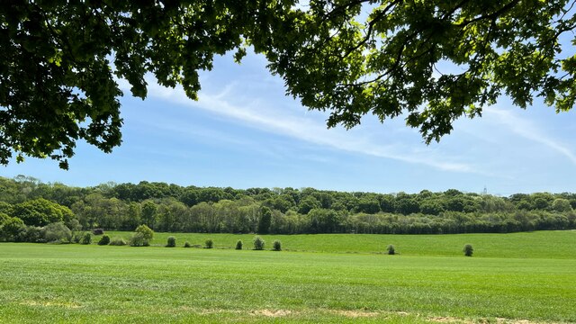
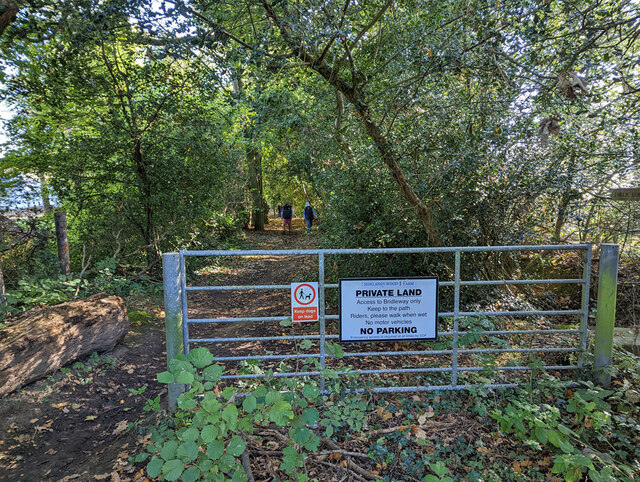
Baker's Shaw is a picturesque woodland located in the county of Sussex, England. Nestled amidst the serene countryside, this forest is a natural haven for both locals and visitors alike. With an area spanning several acres, Baker's Shaw offers an enchanting escape from the hustle and bustle of urban life.

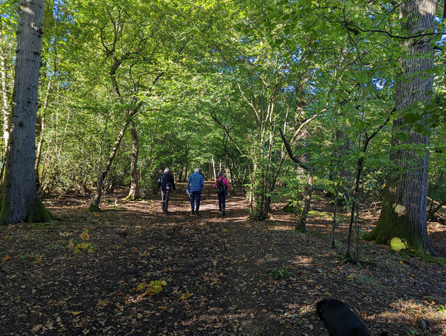
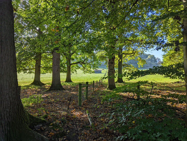
The forest is characterized by its dense canopy of ancient oak and beech trees, which provide a stunning backdrop for leisurely walks and outdoor activities. The towering trees create a sense of tranquility, allowing visitors to immerse themselves in nature's embrace. The forest floor is carpeted with a diverse array of flora, from delicate wildflowers to vibrant mosses, adding to the area's natural beauty.

Baker's Shaw is home to a wide variety of wildlife, making it a popular spot for nature enthusiasts and birdwatchers. Visitors may spot a range of bird species, including woodpeckers, owls, and various songbirds. Squirrels, foxes, and deer are also known to roam the forest, adding to the area's charm and providing opportunities for wildlife photography.

In addition to its natural wonders, Baker's Shaw offers well-maintained walking trails and picnic areas, making it an ideal destination for families and outdoor enthusiasts. The forest is easily accessible, with ample parking and nearby amenities. Whether it's a leisurely stroll, a picnic with loved ones, or simply enjoying the tranquility of nature, Baker's Shaw promises a memorable experience for all who visit.

If you have any feedback on the listing, please let us know in the comments section below.

Baker's Shaw Images

Images are sourced within 2km of 50.994174/-0.27609594 or Grid Reference TQ2123. Thanks to Geograph Open Source API. All images are credited.

Greenhouse near Pict's Farm
Ashurst Cottage There was also a derelict phone box hereabouts.
Ashurst Cottage
There was also a derelict phone box hereabouts.
Scout hut
Scout hut
Cowfold Village Hall
Oakfield Cottages
Oakfield Cottages
View south towards High Hurst Copse This photo was taken from the aptly named Park Lane - aptly because there are a lot of places to park along here, which is helpful from a walker's point of view.
View south towards High Hurst Copse
This photo was taken from the aptly named Park Lane - aptly because there are a lot of places to park along here, which is helpful from a walker's point of view.
House on Burnthouse Lane According to the large-scale map this is called "Little Burnt House".
House on Burnthouse Lane
According to the large-scale map this is called "Little Burnt House".
Bridleway 1726, Lower Beeding
Fields north of Woldringfold
Start of bridleway 1726 on Burnthouse Lane
Cowfold: The Street Co-op convenience store
Cowfold, St. Peter's Church: North eastern aspect
Cowfold: The Olde House
Cowfold, St. Peter's Church: North east part of the churchyard
Cowfold: Margaret Cottages
Cowfold, St. Peter's Church: Stained glass window 1
Cowfold, St. Peter's Church: Stained glass window 1 (detail)
Cowfold, St. Peter's Church: Stained glass window 2
Show me another place!

Baker's Shaw is located at Grid Ref: TQ2123 (Lat: 50.994174, Lng: -0.27609594)

Administrative County: West Sussex

District: Horsham

Police Authority: Sussex

What 3 Words

///remark.ordeals.nasal. Near Cowfold, West Sussex

Related Wikis

Cowfold

Cowfold is a village and civil parish between Billingshurst and Haywards Heath in the Horsham District of West Sussex, England. The village is at the intersection...

St Hugh's Charterhouse

St Hugh's Charterhouse, Parkminster, is the only post-Reformation Carthusian monastery in the United Kingdom. It is located in the parish of Cowfold, West...

Crabtree, West Sussex

Crabtree is a hamlet in the parish of Lower Beeding and in Horsham District of West Sussex, England. It lies on the A281 road 4.4 miles (7.1 km) southeast...

Maplehurst, West Sussex

Maplehurst is a hamlet in the civil parish of Nuthurst, and the Horsham District of West Sussex, England. The hamlet is on the Copsale to Nuthurst road...

West Grinstead railway station

West Grinstead was a railway station on the Steyning Line which served the village of West Grinstead. It had a goods yard with a cattle loading bay and...

Leonardslee

Leonardslee is an English country house and English landscape garden and woodland garden in Lower Beeding, near Horsham, West Sussex, England. The Grade...

Littleworth, West Sussex

Littleworth is a hamlet in the Horsham District of West Sussex, England. It lies on the Partridge Green to Maplehurst road 2.9 miles (4.7 km) north of...

Nuthurst

Nuthurst is a village and civil parish in the Horsham district of West Sussex, England. The north of the parish borders Horsham town, with Nuthurst village...

Nearby Amenities

Located within 500m of 50.994174,-0.27609594
Mini Roundabout
Direction: clockwise
Lat/Long: 50.9906211/-0.2727909
Barrier: stile
Lat/Long: 50.9968916/-0.271712
Bus Stop
Sadlers Gallery
Bus: yes
Naptan AtcoCode: 4400HR0477
Naptan Bearing: W
Naptan CommonName: Sadlers Gallery
Naptan Indicator: o/s school
Naptan Landmark: A281
Naptan NaptanCode: wsxawmdp
Naptan Street: Station Road
Naptan Verified: no
Public Transport: platform
Source: naptan_import
Lat/Long: 50.9905857/-0.2754478
Bus Stop
A272 Cowfold Road
Bus: yes
Naptan AtcoCode: 4400HR1037
Naptan Bearing: E
Naptan BusStopType: CUS
Naptan CommonName: A272 Cowfold Road
Naptan Indicator: HAR
Naptan Landmark: Hail & Ride
Naptan NaptanCode: wsxgawdt
Naptan Street: A272 Cowfold Road
Naptan Verified: no
Public Transport: platform
Source: naptan_import
Lat/Long: 50.9917976/-0.2814021
Bus Stop
A272 Cowfold Road
Bus: yes
Naptan AtcoCode: 4400HR1047
Naptan Bearing: W
Naptan BusStopType: CUS
Naptan CommonName: A272 Cowfold Road
Naptan Indicator: HAR
Naptan Landmark: Hail & Ride
Naptan NaptanCode: wsxgawjd
Naptan Street: A272 Cowfold
Naptan Verified: no
Public Transport: platform
Source: naptan_import
Lat/Long: 50.9918969/-0.2814269
Bus Stop
Brook Farm
Naptan AtcoCode: 4400HR1060
Naptan Bearing: N
Naptan BusStopType: CUS
Naptan CommonName: Brook Farm
Naptan Indicator: opp
Naptan Landmark: Hail & Ride
Naptan NaptanCode: wsxgdada
Naptan Street: A281 Brook Hill
Naptan Verified: no
Public Transport: platform
Source: naptan_import
Lat/Long: 50.9950778/-0.2723335
Bus Stop
Brook Farm
Naptan AtcoCode: 4400HR1061
Naptan Bearing: S
Naptan BusStopType: CUS
Naptan CommonName: Brook Farm
Naptan Indicator: adj
Naptan Landmark: Hail & Ride
Naptan NaptanCode: wsxgdadg
Naptan Street: A281 Brook Hill
Naptan Verified: no
Public Transport: platform
Source: naptan_import
Lat/Long: 50.9950798/-0.272213
Crossing
Button Operated: yes
Crossing: traffic_signals
Crossing Island: yes
Crossing Ref: pelican
Tactile Paving: yes
Traffic Signals: pedestrian_crossing
Traffic Signals Sound: yes
Lat/Long: 50.9906409/-0.2755401
Crossing
Crossing: unmarked
Crossing Island: yes
Crossing Markings: no
Kerb: lowered
Tactile Paving: no
Lat/Long: 50.9906393/-0.2729757
Crossing
Crossing: unmarked
Crossing Island: yes
Crossing Markings: no
Kerb: lowered
Tactile Paving: no
Lat/Long: 50.9907181/-0.2727627
Crossing
Crossing: unmarked
Crossing Island: yes
Crossing Markings: no
Kerb: normal
Tactile Paving: no
Lat/Long: 50.9905099/-0.2727152
Crossing
Button Operated: yes
Crossing: traffic_signals
Crossing Island: yes
Crossing Ref: pelican
Tactile Paving: yes
Traffic Signals: pedestrian_crossing
Traffic Signals Sound: yes
Lat/Long: 50.9907513/-0.2754072
Barrier: kissing_gate
Foot: yes
Lat/Long: 50.9898/-0.2750328
Post Box
Collection Times: Mo-Fr 09:00; Sa 07:00
Operator: Royal Mail
Operator Wikidata: Q638098
Post Box Type: lamp
Ref: RH13 214D
Royal Cypher: EIIR
Royal Cypher Wikidata: Q33102113
Lat/Long: 50.9909091/-0.2758759
Barrier: kissing_gate
Lat/Long: 50.9983948/-0.2780877
Traffic Signals
Traffic Signals: pedestrian_crossing
Traffic Signals Direction: forward
Lat/Long: 50.9907583/-0.2754665
Traffic Signals
Traffic Signals: pedestrian_crossing
Traffic Signals Direction: forward
Lat/Long: 50.990633/-0.2754657
The data included in this document is from www.openstreetmap.org. The data is made available under ODbL.

Have you been to Baker's Shaw?

Leave your review of Baker's Shaw below (or comments, questions and feedback).