Barney's Covert

Wood, Forest in Lincolnshire East Lindsey

England

Barney's Covert

Benniworth: aerial 2022
Benniworth: aerial 2022 Credit: Chris

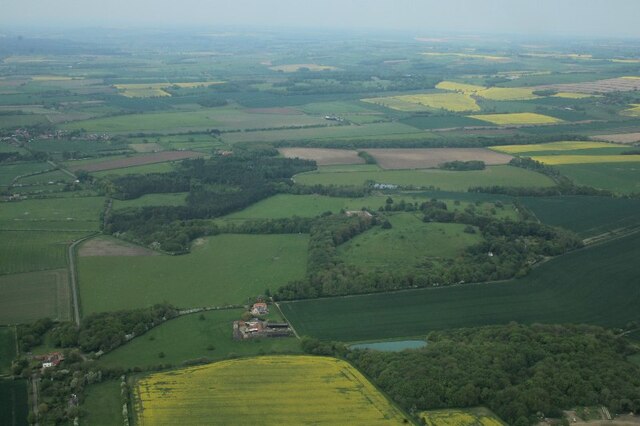
Barney's Covert is a beautiful woodland area located in Lincolnshire, England. Nestled within the heart of the county, it is a haven for nature enthusiasts and those seeking a peaceful escape from the hustle and bustle of everyday life.

Covering a vast area, Barney's Covert is characterized by its dense, ancient woodland. Towering oak and beech trees dominate the landscape, creating a captivating canopy that provides shelter and a home to a diverse range of flora and fauna. The woodland floor is adorned with a vibrant carpet of bluebells, wild garlic, and ferns, adding to the enchanting atmosphere.

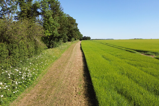
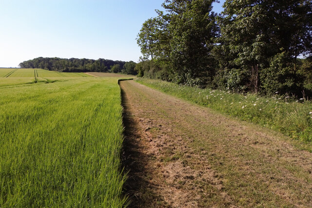
Within Barney's Covert, there are numerous walking trails and paths, allowing visitors to explore its hidden treasures. The terrain is relatively flat, making it accessible to people of all ages and abilities. Along these paths, visitors may encounter various wildlife, including deer, squirrels, and a variety of bird species.

The woodland is also home to a small pond, which serves as a watering hole for many of the area's inhabitants. This serene spot offers a chance to observe dragonflies darting across the water's surface and listen to the soothing chorus of frogs and birds.

Barney's Covert is a popular destination for nature walks, picnics, and photography. Its tranquil ambiance and natural beauty make it an ideal place for relaxation and contemplation. Whether one is seeking solitude or a family outing, Barney's Covert offers a slice of tranquility amidst Lincolnshire's stunning countryside.

If you have any feedback on the listing, please let us know in the comments section below.

Barney's Covert Images

Images are sourced within 2km of 53.313084/-0.20677475 or Grid Reference TF1981. Thanks to Geograph Open Source API. All images are credited.

Benniworth: aerial 2022
Fields near Low Farm, Benniworth: aerial 2022
Benniworth, south: aerial 2022
Stable block at site of Panton Hall: aerial 2022 (1) It dates from 1777 and was probably built by William Legg. It underwent alterations in the 20th century. 

See: <span class="nowrap"><a title="https://www.heritagegateway.org.uk/Gateway/Results_Single.aspx?uid=MLI93551&resourceID=1006" rel="nofollow ugc noopener" href="https://www.heritagegateway.org.uk/Gateway/Results_Single.aspx?uid=MLI93551&resourceID=1006">Link</a><img style="margin-left:2px;" alt="External link" title="External link - shift click to open in new window" src="https://s1.geograph.org.uk/img/external.png" width="10" height="10"/></span>
Stable block at site of Panton Hall: aerial 2022 (1)
It dates from 1777 and was probably built by William Legg. It underwent alterations in the 20th century. See: LinkExternal link
Stable block at site of Panton Hall: aerial 2022 (2) It dates from 1777 and was probably built by William Legg. It underwent alterations in the 20th century. 

See: <span class="nowrap"><a title="https://www.heritagegateway.org.uk/Gateway/Results_Single.aspx?uid=MLI93551&resourceID=1006" rel="nofollow ugc noopener" href="https://www.heritagegateway.org.uk/Gateway/Results_Single.aspx?uid=MLI93551&resourceID=1006">Link</a><img style="margin-left:2px;" alt="External link" title="External link - shift click to open in new window" src="https://s1.geograph.org.uk/img/external.png" width="10" height="10"/></span>
Stable block at site of Panton Hall: aerial 2022 (2)
It dates from 1777 and was probably built by William Legg. It underwent alterations in the 20th century. See: LinkExternal link
Stable block at site of Panton Hall: aerial 2022 (3) It dates from 1777 and was probably built by William Legg. It underwent alterations in the 20th century. 

See: <span class="nowrap"><a title="https://www.heritagegateway.org.uk/Gateway/Results_Single.aspx?uid=MLI93551&resourceID=1006" rel="nofollow ugc noopener" href="https://www.heritagegateway.org.uk/Gateway/Results_Single.aspx?uid=MLI93551&resourceID=1006">Link</a><img style="margin-left:2px;" alt="External link" title="External link - shift click to open in new window" src="https://s1.geograph.org.uk/img/external.png" width="10" height="10"/></span>
Stable block at site of Panton Hall: aerial 2022 (3)
It dates from 1777 and was probably built by William Legg. It underwent alterations in the 20th century. See: LinkExternal link
Panton: aerial 2023 (1)  Park and stable block, which is a listed building dating from 1777. 

Panton Hall itself was demolished in 1964.

See <a href="https://www.geograph.org.uk/photo/3595000">TF1880 : Stable Block at site of Panton Hall: aerial</a>, <span class="nowrap"><a title="http://www.britishlistedbuildings.co.uk/en-195409-stable-block-at-site-of-panton-hall-east#.VZEDdRurQsY" rel="nofollow ugc noopener" href="http://www.britishlistedbuildings.co.uk/en-195409-stable-block-at-site-of-panton-hall-east#.VZEDdRurQsY">Link</a><img style="margin-left:2px;" alt="External link" title="External link - shift click to open in new window" src="https://s1.geograph.org.uk/img/external.png" width="10" height="10"/></span>.
Panton: aerial 2023 (1)
Park and stable block, which is a listed building dating from 1777. Panton Hall itself was demolished in 1964. See TF1880 : Stable Block at site of Panton Hall: aerial, LinkExternal link.
Panton: aerial 2023 (2) Park and stable block, which is a listed building dating from 1777. 

Panton Hall itself was demolished in 1964.

See <a href="https://www.geograph.org.uk/photo/3595000">TF1880 : Stable Block at site of Panton Hall: aerial</a>, <span class="nowrap"><a title="http://www.britishlistedbuildings.co.uk/en-195409-stable-block-at-site-of-panton-hall-east#.VZEDdRurQsY" rel="nofollow ugc noopener" href="http://www.britishlistedbuildings.co.uk/en-195409-stable-block-at-site-of-panton-hall-east#.VZEDdRurQsY">Link</a><img style="margin-left:2px;" alt="External link" title="External link - shift click to open in new window" src="https://s1.geograph.org.uk/img/external.png" width="10" height="10"/></span>.
Panton: aerial 2023 (2)
Park and stable block, which is a listed building dating from 1777. Panton Hall itself was demolished in 1964. See TF1880 : Stable Block at site of Panton Hall: aerial, LinkExternal link.
Panton: aerial 2023 (3) Park, walled garden and stable block. The latter is a listed building dating from 1777. 

Panton Hall itself was demolished in 1964.

See <a href="https://www.geograph.org.uk/photo/3595000">TF1880 : Stable Block at site of Panton Hall: aerial</a>, <span class="nowrap"><a title="http://www.britishlistedbuildings.co.uk/en-195409-stable-block-at-site-of-panton-hall-east#.VZEDdRurQsY" rel="nofollow ugc noopener" href="http://www.britishlistedbuildings.co.uk/en-195409-stable-block-at-site-of-panton-hall-east#.VZEDdRurQsY">Link</a><img style="margin-left:2px;" alt="External link" title="External link - shift click to open in new window" src="https://s1.geograph.org.uk/img/external.png" width="10" height="10"/></span>.
Panton: aerial 2023 (3)
Park, walled garden and stable block. The latter is a listed building dating from 1777. Panton Hall itself was demolished in 1964. See TF1880 : Stable Block at site of Panton Hall: aerial, LinkExternal link.
Station Yard gate Long disused and mostly derelict gate to the Station Yard at South Willingham
Station Yard gate
Long disused and mostly derelict gate to the Station Yard at South Willingham
Track to Panton Stables
Panton Park and Stables, and Warren Farm: aerial 2023
Panton Park and Stables: aerial 2023
Track along Whitepits Plantation A similar view to <a href="https://www.geograph.org.uk/photo/812585">TF1881 : Field edge</a>
Track along Whitepits Plantation
A similar view to TF1881 : Field edge
Track along Whitepits Plantation Looking south towards the road.
The opposite way to <a href="https://www.geograph.org.uk/photo/7513268">TF1881 : Track along Whitepits Plantation</a>
Track along Whitepits Plantation
Looking south towards the road. The opposite way to TF1881 : Track along Whitepits Plantation
St Julian's church, Benniworth The unusual dedication could relate to several Martyrs of that name.
St Julian's church, Benniworth
The unusual dedication could relate to several Martyrs of that name.
Interior, St Julian's church, Benniworth A modest interior.
Interior, St Julian's church, Benniworth
A modest interior.
Organ, St Julian's church, Benniworth 2 Manual and Pedals with 8 stops by W. E. Richardson & Sons, 1896.
Quoted as "nicely voiced".
Organ, St Julian's church, Benniworth
2 Manual and Pedals with 8 stops by W. E. Richardson & Sons, 1896. Quoted as "nicely voiced".
Show me another place!

Barney's Covert is located at Grid Ref: TF1981 (Lat: 53.313084, Lng: -0.20677475)

Administrative County: Lincolnshire

District: East Lindsey

Police Authority: Lincolnshire

What 3 Words

///explores.lyrics.modest. Near Wragby, Lincolnshire

Nearby Locations

Barney's Covert

Related Wikis

Benniworth

Benniworth is a village and civil parish in the East Lindsey district of Lincolnshire, England. The village is situated just west of the B1225 road, and...

South Willingham and Hainton railway station

South Willingham and Hainton railway station was a railway station that served the village of South Willingham, Lincolnshire, England between 1874 and...

South Willingham

South Willingham is a village and civil parish in the East Lindsey district of Lincolnshire, England, and partly within the Lincolnshire Wolds Area of...

Sotby

Sotby is a village and civil parish in the East Lindsey district of Lincolnshire, England. It is situated 15 miles (24 km) north-east from the city and...

East Barkwith railway station

East Barkwith railway station was a railway station that served the village of East Barkwith, Lincolnshire, England between 1874 and 1958, on the Louth...

East Barkwith

East Barkwith is a village and civil parish in the East Lindsey district of Lincolnshire, England. It is situated on the A157, and approximately 13 miles...

Panton, Lincolnshire

Panton is a village in the civil parish of East Barkwith, in the East Lindsey of district, Lincolnshire, England. It is situated approximately 13 miles...

Belmont transmitting station

The Belmont transmitting station is a broadcasting and telecommunications facility next to the B1225, 1 mile (1.6 km) west of the village of Donington...

Nearby Amenities

Located within 500m of 53.313084,-0.20677475
Skirbeck Cottages
Place: isolated_dwelling
Source: Bing
Lat/Long: 53.3155816/-0.2083091
Skirbeck House
Place: isolated_dwelling
Source: Bing
Lat/Long: 53.3159058/-0.2118148
The data included in this document is from www.openstreetmap.org. The data is made available under ODbL.

Have you been to Barney's Covert?

Leave your review of Barney's Covert below (or comments, questions and feedback).