Snelling Planted Field

Wood, Forest in Surrey Mole Valley

England

Snelling Planted Field

Bridge at Ewood Lane
Bridge at Ewood Lane Credit: James Insell

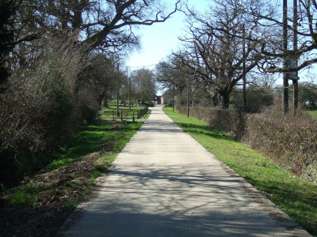
Snelling Planted Field is a picturesque woodland located in Surrey, England. It is situated in the heart of the county, surrounded by rolling hills and lush greenery. This woodland is part of the larger Snelling Forest, which covers a vast area of land and is known for its diverse flora and fauna.

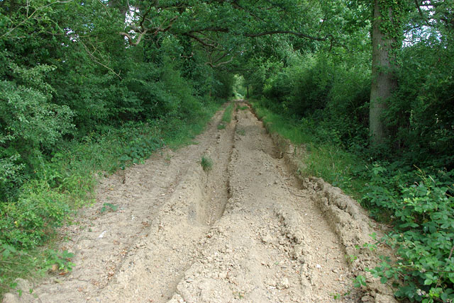
The Planted Field itself is a section of the forest that has been carefully cultivated with a variety of trees and plants. The area is characterized by its dense foliage and towering trees, creating a serene and peaceful atmosphere. The woodland floor is covered in a thick layer of moss, adding to the enchanting ambiance of the area.

The trees in Snelling Planted Field are predominantly native species, such as oak, birch, and beech. These trees provide a rich habitat for a wide range of wildlife, including birds, small mammals, and insects. The forest is a popular spot for birdwatching enthusiasts, who can often spot species such as owls, woodpeckers, and warblers.

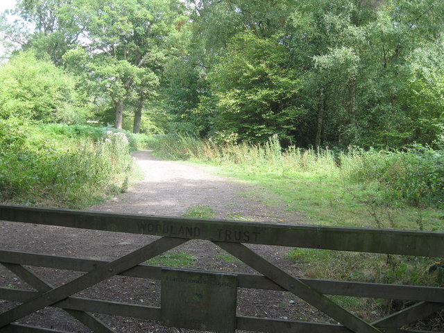
Snelling Planted Field is a haven for nature lovers and outdoor enthusiasts alike. The woodland offers a network of well-maintained walking trails, allowing visitors to explore the area at their own pace. There are also designated picnic areas and benches where visitors can relax and enjoy the peaceful surroundings.

Overall, Snelling Planted Field is a beautiful and tranquil woodland that showcases the natural beauty of Surrey. Its diverse plant life, along with its abundance of wildlife, makes it a must-visit destination for those seeking a peaceful escape in nature.

If you have any feedback on the listing, please let us know in the comments section below.

Snelling Planted Field Images

Images are sourced within 2km of 51.195644/-0.29088612 or Grid Reference TQ1945. Thanks to Geograph Open Source API. All images are credited.

Bridge at Ewood Lane
Entrance to the Woodland Trust's Hammond's Copse
Information point at the Woodland Trust's Hammond's Copse
Pond bay at Ewood, near Newdigate, Surrey Ewood was one of the main centres for ironmaking in the 15th century. The works were water-powered, driven by a pond which is thought to have been 200 acres in size. The pond bay (or dam) can still be seen behind a cottage on Ewood Lane.
Pond bay at Ewood, near Newdigate, Surrey
Ewood was one of the main centres for ironmaking in the 15th century. The works were water-powered, driven by a pond which is thought to have been 200 acres in size. The pond bay (or dam) can still be seen behind a cottage on Ewood Lane.
Houses at Bunce Common looking north-east
Houses at Bunce Common
looking north-east
Junction of Middle Street with Gadbrook Road (left) Looking south.  The former crossroads here has been changed to a staggered junction; Brockhamhurst Road is to the right.
Junction of Middle Street with Gadbrook Road (left)
Looking south. The former crossroads here has been changed to a staggered junction; Brockhamhurst Road is to the right.
Narrow Bridge over the brook Looking North towards Shelwood Cross
Narrow Bridge over the brook
Looking North towards Shelwood Cross
Hammond's Copse
Hammond's Copse
Bridleway at Shellwood Manor
Jubilee Hall Village hall built circa 1885 (according to the name plate) for Queen Victoria's golden jubilee and recently converted into a dwelling. The rusting corrugated iron roof has been replaced with tile but the essential character of the building has been retained.
Jubilee Hall
Village hall built circa 1885 (according to the name plate) for Queen Victoria's golden jubilee and recently converted into a dwelling. The rusting corrugated iron roof has been replaced with tile but the essential character of the building has been retained.
Shellwood Manor Farm Mention of the Manor of Shellwood goes back to at least the 12th century.
Shellwood Manor Farm
Mention of the Manor of Shellwood goes back to at least the 12th century.
Shellwood Cross Junction of Shellwood Road with Clayhill Lane and Broad Lane.  Shellwood Cross Cottage, seen here, dates originally from the 17th century and is grade II listed - for listing particulars see <span class="nowrap"><a title="www.historicengland.org.uk/listing/the-list/list-entry/1287027" rel="nofollow ugc noopener" href="http://www.historicengland.org.uk/listing/the-list/list-entry/1287027">Link</a><img style="margin-left:2px;" alt="External link" title="External link - shift click to open in new window" src="https://s1.geograph.org.uk/img/external.png" width="10" height="10"/></span>.
Shellwood Cross
Junction of Shellwood Road with Clayhill Lane and Broad Lane. Shellwood Cross Cottage, seen here, dates originally from the 17th century and is grade II listed - for listing particulars see LinkExternal link.
Shellwood Road The house on the left, Longacre, is a recent development, replacing a previous house on the site.  

The previous house, thought to date from the 1930s, had become uninhabitable due to structural damage caused by the roots of nearby trees.  Normally green belt rules would have meant that planning permission would only have been granted based on the same footprint as the previous house, in order to avoid encroachment on what was deemed to be open countryside.  However, when planning permission was eventually granted in 2006, a compromise was reached whereby the new house was in a slightly different position, so that the trees that had caused the original problem could be retained, whilst at the same time limiting the visual intrusion that would be caused by a more substantial move within the same plot.
Shellwood Road
The house on the left, Longacre, is a recent development, replacing a previous house on the site. The previous house, thought to date from the 1930s, had become uninhabitable due to structural damage caused by the roots of nearby trees. Normally green belt rules would have meant that planning permission would only have been granted based on the same footprint as the previous house, in order to avoid encroachment on what was deemed to be open countryside. However, when planning permission was eventually granted in 2006, a compromise was reached whereby the new house was in a slightly different position, so that the trees that had caused the original problem could be retained, whilst at the same time limiting the visual intrusion that would be caused by a more substantial move within the same plot.
Main path out of Hammond's Copse This Woodland Trust property has several ways in via public footpaths and bridleways, but there is no public right of way here, although Woodland Trust woods are freely open to the public anyway. Beyond the gate just visible is a parking area for several cars.
Main path out of Hammond's Copse
This Woodland Trust property has several ways in via public footpaths and bridleways, but there is no public right of way here, although Woodland Trust woods are freely open to the public anyway. Beyond the gate just visible is a parking area for several cars.
Agricultural heap of what? Looking like cat litter or unweathered blue clay, this large heap is probably neither.
Agricultural heap of what?
Looking like cat litter or unweathered blue clay, this large heap is probably neither.
Heavily rutted byway Green Lane is currently closed to all traffic, presumably because of the heavy rutting. In its dried out state it is easily walkable, however.
Heavily rutted byway
Green Lane is currently closed to all traffic, presumably because of the heavy rutting. In its dried out state it is easily walkable, however.
Footpath to Gadbrook Road The landowner has mown the start of the path, to indicate the way he wants people to go, but few seem to have used this route.
Footpath to Gadbrook Road
The landowner has mown the start of the path, to indicate the way he wants people to go, but few seem to have used this route.
Footpath, Hammond’s Copse, Parkgate One of the footpaths off Broad Lane into Hammond’s Copse which is managed by the Woodland Trust
Footpath, Hammond’s Copse, Parkgate
One of the footpaths off Broad Lane into Hammond’s Copse which is managed by the Woodland Trust
Show me another place!

Snelling Planted Field is located at Grid Ref: TQ1945 (Lat: 51.195644, Lng: -0.29088612)

Administrative County: Surrey

District: Mole Valley

Police Authority: Surrey

What 3 Words

///draw.fired.jazz. Near Holmwood, Surrey

Nearby Locations

Snelling Planted Field

Related Wikis

Wotton Hundred

The Hundred of Wotton, Wotton Hundred or Dorking Hundred was a hundred in Surrey, England. The hundred comprised a south-central portion of the county...

Newdigate

Newdigate is a village and civil parish in the Mole Valley borough of Surrey lying in a relatively flat part of the Weald to the east of the A24 road between...

South Holmwood

South Holmwood () is a semi-rural village in Surrey, England. It can be considered cognate with its wider civil parish, which stretches to the east to...

Holmwood railway station

Holmwood railway station serves the villages of Beare Green and South Holmwood in Surrey, England, on the Sutton and Mole Valley Lines between Dorking...

Inholms Clay Pit

Inholms Clay Pit is a 8.4-hectare (21-acre) Local Nature Reserve south of Dorking in Surrey. It is owned by Mole Valley District Council and from 2009...

Leigh, Surrey

Leigh is a village and civil parish in Surrey, between Reigate, Dorking and Charlwood in the east of Mole Valley district. The village centre is suburban...

North Holmwood

North Holmwood is a residential area on the outskirts of Dorking, in Surrey, England. The village is accessible from the A24, the village's historic heart...

Newdigate Brickworks

Newdigate Brickworks is a 24-hectare (59-acre) nature reserve in Newdigate in Surrey. It is managed by the Surrey Wildlife Trust.The clay pits of this...

Nearby Amenities

Located within 500m of 51.195644,-0.29088612
Barrier: stile
Lat/Long: 51.1972941/-0.2865027
The data included in this document is from www.openstreetmap.org. The data is made available under ODbL.

Have you been to Snelling Planted Field?

Leave your review of Snelling Planted Field below (or comments, questions and feedback).