Castle Wood

Wood, Forest in Sussex Horsham

England

Castle Wood

Footpath going west in Spring Wood
Footpath going west in Spring Wood Credit: Shazz

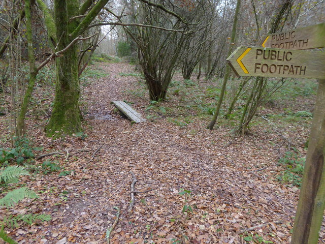
Castle Wood, Sussex is a picturesque forest located in the southern region of England. Spread across a vast area, this enchanting woodland is known for its rich natural beauty and historical significance. Nestled amidst the rolling hills and verdant landscapes of Sussex, Castle Wood offers a tranquil escape from the bustling city life.

The forest is home to a diverse range of flora and fauna, with ancient oak trees, vibrant wildflowers, and a myriad of wildlife species. Walking along its well-marked trails, visitors can immerse themselves in the serene ambiance and enjoy the soothing sounds of birds chirping and leaves rustling in the wind.

As the name suggests, Castle Wood has historical ties, as it was once the site of a medieval castle. Ruins of the castle still stand tall, serving as a reminder of the region's rich heritage. History enthusiasts can explore these remnants and imagine the castle's former grandeur.

Castle Wood also offers recreational activities for outdoor enthusiasts. The forest is a popular destination for hiking, cycling, and picnicking. Its well-maintained paths provide ample opportunities for visitors to engage in outdoor pursuits while soaking in the beauty of the surrounding scenery.

Throughout the year, Castle Wood hosts various events and activities to engage the local community and attract tourists. From guided nature walks to educational workshops, the forest fosters a sense of environmental awareness and appreciation for the natural world.

In conclusion, Castle Wood, Sussex is a captivating forest that combines natural beauty, historical significance, and recreational opportunities. Whether one seeks a peaceful retreat or an adventure in nature, this woodland is a must-visit destination for nature enthusiasts and history buffs alike.

If you have any feedback on the listing, please let us know in the comments section below.

Castle Wood Images

Images are sourced within 2km of 51.030539/-0.31784516 or Grid Reference TQ1827. Thanks to Geograph Open Source API. All images are credited.

Footpath going west in Spring Wood
Footpath with plank bridge in Spring Wood This bridge is also seen at <a title="https://www.geograph.org.uk/photo/1862706" href="https://www.geograph.org.uk/photo/1862706">Link</a>.
Footpath with plank bridge in Spring Wood
This bridge is also seen at Link.
Footpath junction and plank bridge in Spring Wood This bridge is also seen at <a title="https://www.geograph.org.uk/photo/1862706" href="https://www.geograph.org.uk/photo/1862706">Link</a>.
Footpath junction and plank bridge in Spring Wood
This bridge is also seen at Link.
Footpath junction signpost, Spring Wood
Stansford Copse
Stansford Copse
Exotic trees near Cooks Farm The ones in the background were very tall, and looked like some kind of eucalyptus. There's a kind of garden centre nearby that sells "architectural plants".
Exotic trees near Cooks Farm
The ones in the background were very tall, and looked like some kind of eucalyptus. There's a kind of garden centre nearby that sells "architectural plants".
Tree trunk - south of Cooks Farm There are several of these trees alongside this section of track. The stripped bark suggests some kind of eucalyptus to me. See also: <a href="https://www.geograph.org.uk/photo/7004751">TQ1926 : Exotic trees near Cooks Farm</a>. The pastel colour palette has a hint of Farrow and Ball about it!
Tree trunk - south of Cooks Farm
There are several of these trees alongside this section of track. The stripped bark suggests some kind of eucalyptus to me. See also: TQ1926 : Exotic trees near Cooks Farm. The pastel colour palette has a hint of Farrow and Ball about it!
Autumn leaves
Autumn leaves
Autumn leaves
Autumn leaves
Nuthurst Farmhouse
Nuthurst Farmhouse
Exotic trees and shrubs in Nuthurst There's some kind of upmarket garden centre hereabouts I think.
Exotic trees and shrubs in Nuthurst
There's some kind of upmarket garden centre hereabouts I think.
Window, shutters and bamboo This was an architectural plant centre, though I think they've now moved their business to Pulborough according to their website. The site has a number of curious colonial style buildings, for want of a better description. Exotic species are also much in evidence around nearby Cook's Farm.
Window, shutters and bamboo
This was an architectural plant centre, though I think they've now moved their business to Pulborough according to their website. The site has a number of curious colonial style buildings, for want of a better description. Exotic species are also much in evidence around nearby Cook's Farm.
Bamboo at the former "Architectural Plants" nursery Their website says that they have moved their operation to Pulborough.
Bamboo at the former "Architectural Plants" nursery
Their website says that they have moved their operation to Pulborough.
Outbuilding near Cook's Farm I think these curious outbuildings may be connected with the nearby "Architectural Plants" nursery. The nursery business has, according to their website, now moved to Pulborough - though the Nuthurst site still looks like a nursery.
Outbuilding near Cook's Farm
I think these curious outbuildings may be connected with the nearby "Architectural Plants" nursery. The nursery business has, according to their website, now moved to Pulborough - though the Nuthurst site still looks like a nursery.
Tiles in the porch of St Andrew's Church
Bracket fungi
Bracket fungi
Antipodean style, Nuthurst Gum trees, tin roof, veranda, could be in Australia.
Antipodean style, Nuthurst
Gum trees, tin roof, veranda, could be in Australia.
Outbuildings, Cook's Farm
Show me another place!

Castle Wood is located at Grid Ref: TQ1827 (Lat: 51.030539, Lng: -0.31784516)

Administrative County: West Sussex

District: Horsham

Police Authority: Sussex

What 3 Words

///revised.canoe.multiples. Near Southwater, West Sussex

Related Wikis

Southwater & Nuthurst (electoral division)

Southwater & Nuthurst is an electoral division of West Sussex in the United Kingdom and returns one member to sit on West Sussex County Council. The current...

Nuthurst

Nuthurst is a village and civil parish in the Horsham district of West Sussex, England. The north of the parish borders Horsham town, with Nuthurst village...

Monk's Gate

Monk's Gate is a hamlet in the civil parish of Nuthurst, in the Horsham District of West Sussex, England. It lies on the A281 road 3 miles (5 km) southeast...

Copsale

Copsale is a hamlet in the civil parish of Nuthurst, and the Horsham District of West Sussex, England. It lies on the Southwater to Maplehurst road 3.5...

Copthorne F.C.

Copthorne Football Club is a football club based in Copthorne in West Sussex, England. They are currently members of the Southern Combination Division...

Horsham F.C.

Horsham Football Club are a non-League football club based in Horsham, West Sussex, England, currently playing in the Isthmian League Premier Division...

Haywards Heath Town F.C. Women

Haywards Heath Town F.C. Women (formerly Crawley Wasps Ladies FC) is an English women's football club, that currently plays in the FA Women's National...

Southwater railway station

Southwater was a railway station on the Steyning Line which served the village of Southwater. A goods siding allowed for the transportation of coal and...

Nearby Amenities

Located within 500m of 51.030539,-0.31784516
Annexe
Addr City: Horsham
Addr Housename: Annexe, West Sedgwick Park
Addr Postcode: RH13 6QQ
Addr Street: Sedgwick Park
Lat/Long: 51.027651/-0.3157803
Addr City: Horsham
Addr Housename: Fox Cottage
Addr Postcode: RH13 6QQ
Addr Street: Sedgwick Park
Building: house
Lat/Long: 51.0273523/-0.3138849
Addr City: Horsham
Addr Housename: The Laurels
Addr Postcode: RH13 6QQ
Addr Street: Sedgwick Park
Building: house
Lat/Long: 51.0273777/-0.3140088
Addr City: Horsham
Addr Housename: Winterbourne House
Addr Postcode: RH13 6QQ
Addr Street: Sedgwick Park
Building: house
Lat/Long: 51.0319535/-0.3113758
Park Farm
Place: farm
Lat/Long: 51.0312123/-0.3114755
Sedgwick Park
Place: isolated_dwelling
Lat/Long: 51.0273718/-0.3136481
Sedgwick Castle
Access: private
Castle Type: defensive
Historic: castle
Historic Civilization: medieval
Lat/Long: 51.03003/-0.3184567
The data included in this document is from www.openstreetmap.org. The data is made available under ODbL.

Have you been to Castle Wood?

Leave your review of Castle Wood below (or comments, questions and feedback).