Ings Plantation

Wood, Forest in Lincolnshire East Lindsey

England

Ings Plantation

Ridge and furrow fields, Back o' Frank's Hill, near Panton : aerial 2022 See: <span class="nowrap"><a title="https://www.heritagegateway.org.uk/Gateway/Results_Single.aspx?uid=MLI88912&resourceID=1006" rel="nofollow ugc noopener" href="https://www.heritagegateway.org.uk/Gateway/Results_Single.aspx?uid=MLI88912&resourceID=1006">Link</a><img style="margin-left:2px;" alt="External link" title="External link - shift click to open in new window" src="https://s1.geograph.org.uk/img/external.png" width="10" height="10"/></span>
Ridge and furrow fields, Back o' Frank's Hill, near Panton : aerial 2022 Credit: Simon Tomson

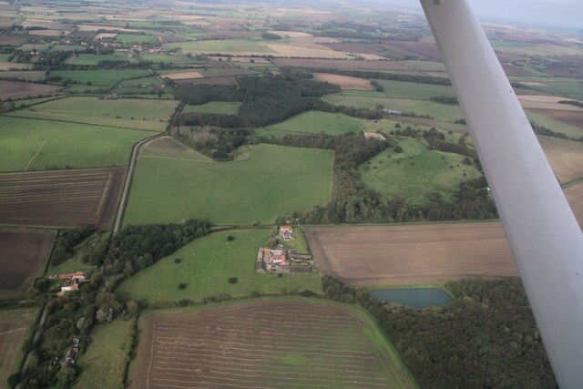
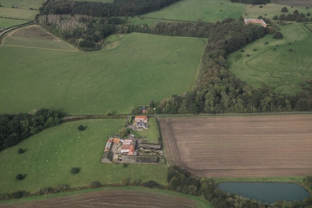
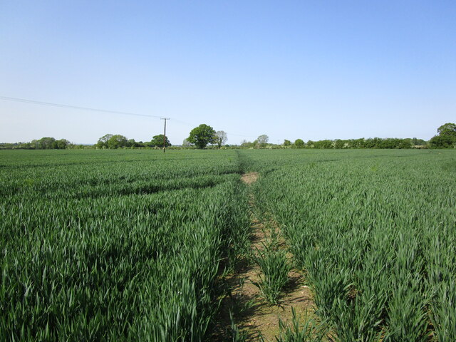
Ings Plantation, located in Lincolnshire, is a picturesque woodland area that covers a vast expanse of land. This plantation is known for its dense and thriving forests, making it a haven for nature enthusiasts and wildlife lovers alike. The plantation is situated in the heart of the Lincolnshire Wolds, an Area of Outstanding Natural Beauty, which further adds to its allure.

The Wood at Ings Plantation is a diverse habitat, housing a wide variety of tree species including oak, beech, ash, and birch. The forest floor is adorned with a rich carpet of wildflowers, ferns, and mosses, creating a vibrant and enchanting atmosphere. The dense canopy of trees provides shade and shelter for a wealth of wildlife, including deer, foxes, badgers, and numerous bird species.

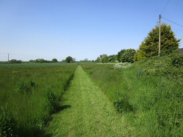
Visitors to Ings Plantation can explore the woodland through a network of well-maintained walking trails. These trails meander through the forest, offering glimpses of ancient trees, hidden glades, and peaceful streams. The plantation is also home to a number of designated picnic areas, allowing visitors to enjoy the tranquility of the surroundings.

In addition to its natural beauty, Ings Plantation has historical significance. The wood has been managed for centuries and was once part of a larger estate owned by a prominent local family. Remnants of this history can still be seen in the form of old stone walls, ruins, and the occasional ornamental planting.

Overall, Ings Plantation is a captivating woodland retreat that showcases the beauty of Lincolnshire's natural landscape. Its abundance of flora and fauna, coupled with its historical charm, make it a must-visit destination for anyone seeking solace in nature.

If you have any feedback on the listing, please let us know in the comments section below.

Ings Plantation Images

Images are sourced within 2km of 53.317821/-0.23145255 or Grid Reference TF1781. Thanks to Geograph Open Source API. All images are credited.

Ridge and furrow fields, Back o' Frank's Hill, near Panton : aerial 2022 See: <span class="nowrap"><a title="https://www.heritagegateway.org.uk/Gateway/Results_Single.aspx?uid=MLI88912&resourceID=1006" rel="nofollow ugc noopener" href="https://www.heritagegateway.org.uk/Gateway/Results_Single.aspx?uid=MLI88912&resourceID=1006">Link</a><img style="margin-left:2px;" alt="External link" title="External link - shift click to open in new window" src="https://s1.geograph.org.uk/img/external.png" width="10" height="10"/></span>
Ridge and furrow fields, Back o' Frank's Hill, near Panton : aerial 2022
See: LinkExternal link
Goddard Hill and Warren Hill to Panton Park: aerial 2023 See also <a href="https://www.geograph.org.uk/photo/7629789">TF1879 : Warren Farm to Panton Park: aerial 2023</a> and <a href="https://www.geograph.org.uk/photo/7629829">TF1880 : Panton Park and stable block: aerial 2023</a>.
Goddard Hill and Warren Hill to Panton Park: aerial 2023
Warren Farm to Panton Park: aerial 2023 See also <a href="https://www.geograph.org.uk/photo/7629783">TF1879 : Goddard Hill and Warren Hill to Panton Park: aerial 2023</a>.
Warren Farm to Panton Park: aerial 2023
Fields near Low Farm, Benniworth: aerial 2022
Ridge and furrow and earthworks, near Eastlands Farm, East Barkwith: aerial 2022 (1) See also <a href="https://www.geograph.org.uk/photo/7166471">TF1782 : Ridge and furrow and earthworks, near Eastlands Farm, East Barkwith: aerial 2022 (2)</a>.
Ridge and furrow and earthworks, near Eastlands Farm, East Barkwith: aerial 2022 (1)
Ridge and furrow and earthworks, near Eastlands Farm, East Barkwith: aerial 2022 (2) See also <a href="https://www.geograph.org.uk/photo/7166470">TF1682 : Ridge and furrow and earthworks, near Eastlands Farm, East Barkwith: aerial 2022 (1)</a>.
Ridge and furrow and earthworks, near Eastlands Farm, East Barkwith: aerial 2022 (2)
Stable block at site of Panton Hall: aerial 2022 (1) It dates from 1777 and was probably built by William Legg. It underwent alterations in the 20th century. 

See: <span class="nowrap"><a title="https://www.heritagegateway.org.uk/Gateway/Results_Single.aspx?uid=MLI93551&resourceID=1006" rel="nofollow ugc noopener" href="https://www.heritagegateway.org.uk/Gateway/Results_Single.aspx?uid=MLI93551&resourceID=1006">Link</a><img style="margin-left:2px;" alt="External link" title="External link - shift click to open in new window" src="https://s1.geograph.org.uk/img/external.png" width="10" height="10"/></span>
Stable block at site of Panton Hall: aerial 2022 (1)
It dates from 1777 and was probably built by William Legg. It underwent alterations in the 20th century. See: LinkExternal link
Stable block at site of Panton Hall: aerial 2022 (2) It dates from 1777 and was probably built by William Legg. It underwent alterations in the 20th century. 

See: <span class="nowrap"><a title="https://www.heritagegateway.org.uk/Gateway/Results_Single.aspx?uid=MLI93551&resourceID=1006" rel="nofollow ugc noopener" href="https://www.heritagegateway.org.uk/Gateway/Results_Single.aspx?uid=MLI93551&resourceID=1006">Link</a><img style="margin-left:2px;" alt="External link" title="External link - shift click to open in new window" src="https://s1.geograph.org.uk/img/external.png" width="10" height="10"/></span>
Stable block at site of Panton Hall: aerial 2022 (2)
It dates from 1777 and was probably built by William Legg. It underwent alterations in the 20th century. See: LinkExternal link
Stable block at site of Panton Hall: aerial 2022 (3) It dates from 1777 and was probably built by William Legg. It underwent alterations in the 20th century. 

See: <span class="nowrap"><a title="https://www.heritagegateway.org.uk/Gateway/Results_Single.aspx?uid=MLI93551&resourceID=1006" rel="nofollow ugc noopener" href="https://www.heritagegateway.org.uk/Gateway/Results_Single.aspx?uid=MLI93551&resourceID=1006">Link</a><img style="margin-left:2px;" alt="External link" title="External link - shift click to open in new window" src="https://s1.geograph.org.uk/img/external.png" width="10" height="10"/></span>
Stable block at site of Panton Hall: aerial 2022 (3)
It dates from 1777 and was probably built by William Legg. It underwent alterations in the 20th century. See: LinkExternal link
Panton: aerial 2023 (1)  Park and stable block, which is a listed building dating from 1777. 

Panton Hall itself was demolished in 1964.

See <a href="https://www.geograph.org.uk/photo/3595000">TF1880 : Stable Block at site of Panton Hall: aerial</a>, <span class="nowrap"><a title="http://www.britishlistedbuildings.co.uk/en-195409-stable-block-at-site-of-panton-hall-east#.VZEDdRurQsY" rel="nofollow ugc noopener" href="http://www.britishlistedbuildings.co.uk/en-195409-stable-block-at-site-of-panton-hall-east#.VZEDdRurQsY">Link</a><img style="margin-left:2px;" alt="External link" title="External link - shift click to open in new window" src="https://s1.geograph.org.uk/img/external.png" width="10" height="10"/></span>.
Panton: aerial 2023 (1)
Park and stable block, which is a listed building dating from 1777. Panton Hall itself was demolished in 1964. See TF1880 : Stable Block at site of Panton Hall: aerial, LinkExternal link.
Panton: aerial 2023 (2) Park and stable block, which is a listed building dating from 1777. 

Panton Hall itself was demolished in 1964.

See <a href="https://www.geograph.org.uk/photo/3595000">TF1880 : Stable Block at site of Panton Hall: aerial</a>, <span class="nowrap"><a title="http://www.britishlistedbuildings.co.uk/en-195409-stable-block-at-site-of-panton-hall-east#.VZEDdRurQsY" rel="nofollow ugc noopener" href="http://www.britishlistedbuildings.co.uk/en-195409-stable-block-at-site-of-panton-hall-east#.VZEDdRurQsY">Link</a><img style="margin-left:2px;" alt="External link" title="External link - shift click to open in new window" src="https://s1.geograph.org.uk/img/external.png" width="10" height="10"/></span>.
Panton: aerial 2023 (2)
Park and stable block, which is a listed building dating from 1777. Panton Hall itself was demolished in 1964. See TF1880 : Stable Block at site of Panton Hall: aerial, LinkExternal link.
Panton: aerial 2023 (3) Park, walled garden and stable block. The latter is a listed building dating from 1777. 

Panton Hall itself was demolished in 1964.

See <a href="https://www.geograph.org.uk/photo/3595000">TF1880 : Stable Block at site of Panton Hall: aerial</a>, <span class="nowrap"><a title="http://www.britishlistedbuildings.co.uk/en-195409-stable-block-at-site-of-panton-hall-east#.VZEDdRurQsY" rel="nofollow ugc noopener" href="http://www.britishlistedbuildings.co.uk/en-195409-stable-block-at-site-of-panton-hall-east#.VZEDdRurQsY">Link</a><img style="margin-left:2px;" alt="External link" title="External link - shift click to open in new window" src="https://s1.geograph.org.uk/img/external.png" width="10" height="10"/></span>.
Panton: aerial 2023 (3)
Park, walled garden and stable block. The latter is a listed building dating from 1777. Panton Hall itself was demolished in 1964. See TF1880 : Stable Block at site of Panton Hall: aerial, LinkExternal link.
Track to Panton Stables
The former East Barkwith Station This was opened in 1874 by the Louth and Lincoln Railway on its line from Bardney to Louth. It closed to passengers in 1951 and to all traffic in 1958.
The former East Barkwith Station
This was opened in 1874 by the Louth and Lincoln Railway on its line from Bardney to Louth. It closed to passengers in 1951 and to all traffic in 1958.
Barkwith Hall Comuunity building serving East and West Barkwith.
Barkwith Hall
Comuunity building serving East and West Barkwith.
Footbridge over a drain The footpath runs from East Barkwith to West Torrington.
Footbridge over a drain
The footpath runs from East Barkwith to West Torrington.
Footpath to East Barkwith Near Glebe Farm.
Footpath to East Barkwith
Near Glebe Farm.
Footpath to East Barkwith Near Glebe Farm.
Footpath to East Barkwith
Near Glebe Farm.
Show me another place!

Ings Plantation is located at Grid Ref: TF1781 (Lat: 53.317821, Lng: -0.23145255)

Administrative County: Lincolnshire

District: East Lindsey

Police Authority: Lincolnshire

What 3 Words

///drips.swimsuits.question. Near Wragby, Lincolnshire

Nearby Locations

Ings Plantation

Related Wikis

East Barkwith railway station

East Barkwith railway station was a railway station that served the village of East Barkwith, Lincolnshire, England between 1874 and 1958, on the Louth...

East Barkwith

East Barkwith is a village and civil parish in the East Lindsey district of Lincolnshire, England. It is situated on the A157, and approximately 13 miles...

South Willingham and Hainton railway station

South Willingham and Hainton railway station was a railway station that served the village of South Willingham, Lincolnshire, England between 1874 and...

West Barkwith

West Barkwith is a village and civil parish in the East Lindsey district of Lincolnshire, England. It is situated on the A157 road and about 2.5 miles...

South Willingham

South Willingham is a village and civil parish in the East Lindsey district of Lincolnshire, England, and partly within the Lincolnshire Wolds Area of...

Panton, Lincolnshire

Panton is a village in the civil parish of East Barkwith, in the East Lindsey of district, Lincolnshire, England. It is situated approximately 13 miles...

Benniworth

Benniworth is a village and civil parish in the East Lindsey district of Lincolnshire, England. The village is situated just west of the B1225 road, and...

Hainton

Hainton is a village and civil parish in the East Lindsey district of Lincolnshire, England. It is situated on the A157 road, 10 miles (16 km) west from...

Nearby Amenities

Located within 500m of 53.317821,-0.23145255
Power: pole
Lat/Long: 53.3208969/-0.2362972
Power: pole
Lat/Long: 53.3214907/-0.2348068
Power: pole
Lat/Long: 53.3220821/-0.2333204
Grove Farm
Place: farm
Source: Bing
Lat/Long: 53.3163019/-0.2347616
Grove Farm Cottages
Place: isolated_dwelling
Source: Bing
Lat/Long: 53.3166825/-0.2374707
Glendene
Place: isolated_dwelling
Source: Bing
Lat/Long: 53.3200117/-0.2372657
The data included in this document is from www.openstreetmap.org. The data is made available under ODbL.

Have you been to Ings Plantation?

Leave your review of Ings Plantation below (or comments, questions and feedback).